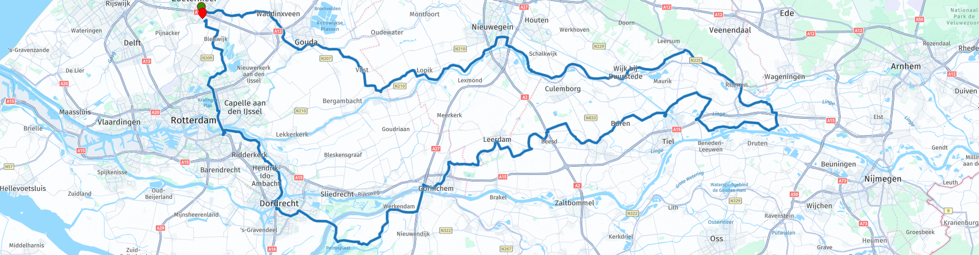
Roundtour Midden Nederland from Zoetermeer

Diese Route wurde erstellt von:
RouteXpert Peter Moerman - RouteXpert
Letzte Änderung: 02-04-2021
 Routenzusammenfassung
 Diese abwechslungsreiche Route bietet für jeden etwas, schöne kurvenreiche Deiche, Polderstraßen, hohe Brücken, eine Fähre und schöne Orte. Auf dem Weg gibt es reichlich Gelegenheit, die innere Person zu stärken.
Ich bewerte diese Route mit 4 Sternen wegen der schönen Straßen, der abwechslungsreichen Landschaft, der Natur und der schönen Städte.
 Diese Route teilen


Animation

Urteil


Dauer
9h 38m

Reisemodus
Auto oder Motorrad

Entfernung
267.01 km

Länder

 RouteXpert-Überprüfung
 Der Amsterdam-Rhein-Kanal verläuft von der Waal bei Tiel zum IJ in Amsterdam und ist 72 km lang. Es ist der verkehrsreichste Kanal der Welt mit mehr als 100.000 Schiffen pro Jahr. Es wurde 1951 eröffnet. Weiter entlang der Route überqueren Sie diesen Kanal erneut. Nach dem Passieren des Kanals geht es weiter über den Lekdijk nach Culemborg. Diese befestigte Stadt wird bereits im 13. Jahrhundert erwähnt und seitdem gibt es auch eine Burg. Es hat also eine lange und turbulente Geschichte. Heute ist es hauptsächlich eine attraktive Stadt, um sie zu besuchen und vorerst eine Tasse Kaffee oder etwas anderes zu trinken. An der Stadtmauer gibt es 2 Orte, an denen man etwas trinken kann.
Von Culemborg geht es weiter in Richtung Amerongen. Beim Betreten von Amerongen fahren Sie am gleichnamigen Schloss mit wunderschönen Schlossgärten vorbei. Seit 1287 befindet sich hier eine Burg, die durch einen Brand zerstört und mehrmals umgebaut wurde. Das Schloss war bis 1977 in Privatbesitz, danach wurde es an die Utrecht Castles Foundation verkauft. Insgesamt besteht der Garten aus zehn Hektar. Im Garten sind vier Jahrhunderte Geschichte zu sehen. Die Gartenarchitekten Eduard André und Hugo Poortman sind die letzten, die den Gartenstil anpassen. Sie modernisierten den Garten 1887 und 1924 für Graf Van Aldenburg Bentinck. Ein Besuch lohnt sich auf jeden Fall.
Nach Amerongen folgt die Route weiterhin dem Nederrijn nach Rhenen, wo Sie die Brücke nach Betuwe überqueren.
Die Betuwe ist eine Region in der niederländischen Provinz Gelderland, die zwischen den Flüssen Waal im Süden und Nederrijn und Lek im Norden liegt. Die Betuwe ist am bekanntesten für den großflächigen Gartenbau, insbesondere den Obstanbau (Äpfel, Birnen, Kirschen und Pflaumen). Die Ursache dieser Landnutzung liegt in der Geologie und den Bodenverhältnissen der Region. Fruchtbarer Flusston kommt in fast der gesamten Betuwe im Boden vor.
Die Route schlängelt sich durch die Obstgärten und führt über schöne kurvenreiche Deichstraßen nach Tiel, wo der Amsterdam-Rhein-Kanal erneut überquert wird. Dann fahren Sie nach Buren. Die Mittagspause ist in diesem Oranjestad geplant.
Buren erhielt 1395 die Stadtrechte von Ritter Allard, Lord van Buren und Beusichem. Burens Befestigungen sind noch weitgehend intakt. Es gibt immer noch Stadtmauern, Mauern und ein Stadttor; die Culemborgse oder Huizenpoort. Buren kann sich wegen der Verbindung zur königlichen Familie Oranjestad nennen. Wilhelm von Oranien heiratete dort 1551 Anna van Buren. Prinzessin Beatrix und König Willem-Alexander sind daher Gräfin und Graf von Buren.
Nach der Mittagspause setzen Sie die Route durch Städte wie Geldermalsen, Beesd, Asperen und Leerdam am Fluss Linge fort. Dieser Fluss fließt von Doornenburg nach Gorinchem und wird in Tiel vom Amsterdam-Rhein-Kanal halbiert. In Gorinchem überquert die Route die Waal nach Werkendam. Leider ist hier ein kleiner Autobahnabschnitt erforderlich. In Werkendam betreten Sie den Nationalpark De Biesbosch.
Der niederländische Nationalpark De Biesbosch ist ein sehr wasserreiches Natur- und Erholungsgebiet. Charakteristisch sind die Süßwasserfluten, Bäche und Weidenwälder. Es besteht aus einer Reihe von Flussinseln sowie Sand- und Wattenmeeren in den Provinzen Nordbrabant und Zuid-Holland. 1994 erhielt die Region den Status eines Nationalparks, seitdem heißt sie offiziell Nationalpark De Biesbosch und steht auf der Liste der Naturschutzgebiete. Der Biesbosch wird teilweise für landwirtschaftliche Zwecke genutzt.
Große Teile dieses Gebiets sind für den motorisierten Verkehr nicht zugänglich, aber die Route durchquert immer noch einen großen Teil des Gebiets. Über die Fähre geht es weiter in Richtung Dordrecht und Rotterdam. Ein weiterer Kaffeestopp ist in Ridderkerk geplant. Bei schönem Wetter können Sie hier auf der Terrasse am Wasser sitzen. In Rotterdam kehrt die Route zur Autobahn zurück, um die Nieuwe Maas über die Brienenoordbrücke zu überqueren. Die letzten Kilometer nach Zoetermeer führen über Kralingse Bos und die Rottemeren. Die Route endet wieder am Parkplatz bei McDonald's.
Sie können die Tour natürlich überall auf der Route starten und beenden. In MRA können Sie dies mit ein wenig Geschick nach Belieben anpassen. Sie müssen die Stopps selbst planen.


 Links
Links  Nutzung
 Möchten Sie diese Route herunterladen?
Sie können die Route ohne MyRoute-App-Konto kostenlos herunterladen. Öffnen Sie dazu die Route und klicken Sie auf 'Speichern unter'. Möchten Sie diese Route bearbeiten?
Kein Problem, starten Sie mit dem Öffnen der Route. Folgen Sie dem Tutorial und erstellen Sie Ihr persönliches MyRoute-App-Konto. Nach der Registrierung startet Ihre Testversion automatisch.  Haftungsausschluss
Die Nutzung dieser GPS-Route erfolgt auf eigene Kosten und Gefahr. Die Route wurde sorgfältig von einem MyRoute-App akkreditierten RouteXpert für die Verwendung mit TomTom, Garmin und MyRoute-App Navigation zusammengestellt und geprüft.
Durch geänderte Umstände, Straßenumleitungen oder saisonale Sperren können sich dennoch Änderungen ergeben haben. Wir empfehlen daher, jede Route vor der Nutzung zu überprüfen.
Verwenden Sie vorzugsweise den Routentrack in Ihrem Navigationssystem. Mehr Informationen zu den Die Nutzung der MyRoute-App finden Sie auf der Website unter 'Community' oder 'Academy'.

Provinz Utrecht
Über diese Region
Utrecht (ˈytrɛxt, ) ist eine niederländische Gemeinde und die Hauptstadt der Provinz Utrecht. Am 1. Januar 2021 betrug die Einwohnerzahl 359.376 (Agglomeration: 660.000). Die viertgrößte Stadt der Niederlande liegt zentral im Lande, weswegen dem Bahnhof Utrecht Centraal große Bedeutung für Fernverbindungen zukommt. Utrecht verfügt über eine bedeutende Universität, eine Musikhochschule (Conservatorium) und eine Fachhochschule (Hogeschool). Die Stadt ist Sitz sowohl eines römisch-katholischen als auch eines altkatholischen Erzbischofs und ist Geburtsort von Papst Hadrian VI.
Westlich der Stadt rings um Vleuten liegt der Planstadtteil Leidsche Rijn. Das auf einer Fläche von rund 20 Quadratkilometern größte Stadtbauprojekt der Niederlande soll insgesamt 100.000 Menschen Wohnraum und Arbeitsstätten bieten. Bei der Planung dieses Musterstadtteils wurde Wert darauf gelegt, dass eine möglichst kleinteilige Siedlungsweise mit vielen Eigenheimen, die oft an den Ufern kleiner Kanäle liegen, verwirklicht wird. Die Bewohner sollen alle Infrastruktureinrichtungen wie Kinderbetreuung, Schulen, Einkaufszentren, Freizeit- und Sporteinrichtungen über das Radwegenetz möglichst schnell erreichen.
Lesen Sie mehr auf Wikipedia
Westlich der Stadt rings um Vleuten liegt der Planstadtteil Leidsche Rijn. Das auf einer Fläche von rund 20 Quadratkilometern größte Stadtbauprojekt der Niederlande soll insgesamt 100.000 Menschen Wohnraum und Arbeitsstätten bieten. Bei der Planung dieses Musterstadtteils wurde Wert darauf gelegt, dass eine möglichst kleinteilige Siedlungsweise mit vielen Eigenheimen, die oft an den Ufern kleiner Kanäle liegen, verwirklicht wird. Die Bewohner sollen alle Infrastruktureinrichtungen wie Kinderbetreuung, Schulen, Einkaufszentren, Freizeit- und Sporteinrichtungen über das Radwegenetz möglichst schnell erreichen.
Region anzeigen
 Statistik
  61
61Anzahl der RX-Bewertungen (Provinz Utrecht)
 42819
42819Anzahl der Besucher (Provinz Utrecht)
 15114
15114Anzahl der Downloads (Provinz Utrecht)
 Routensammlungen in dieser Region
 Die 10 schönsten Auto- und Motorradrouten in den Niederlanden
Diese 10 Routen in den Niederlanden wurden von einem MyRoute-App RouteXpert sorgfältig ausgewählt, geprüft und für TomTom, Garmin und MyRoute-App Navigation gleichgestellt. Die 10 schönsten Motorrad- und Autorouten in den Niederlanden sind immer eine Momentaufnahme und eine persönliche Meinung des Rezensenten. Das ändert nichts daran, dass jeder Liebhaber schöner Straßen und interessanter Sehenswürdigkeiten diese Strecken genießen wird.
Die zehn Routen verteilen sich auf 10 Provinzen, wir haben nur Flevoland und Südholland übersprungen. Interessante Routen finden sich auch in der MyRoute App RouteXpert Bibliothek, wir wollen aber trotzdem bei den 10 schönsten bleiben und nicht bei den 12 schönsten.
Genießen Sie die vielen Festungen und Schlösser, die in den Routen enthalten sind, wie zum Beispiel Fort Veldhuis in Nordholland. Werfen Sie aber auch einen Blick auf die Route südöstlich von Nijmegen und besuchen Sie den beeindruckenden Canadian War Cemetery and Memorial. Die Route 'Overijssel aus der Vogelperspektive' beinhaltet das älteste Haus der Niederlande und die Route entlang der IJssel ist wahrscheinlich das schönste Stück Asphalt der Niederlande.
So ist in dieser Routensammlung für jeden etwas dabei. Wenn Sie mit diesen 10 Routen nicht einverstanden sind, senden Sie uns bitte eine E-Mail, geben Sie an, welche Route(n) entfernt werden sollen und welche Route Sie stattdessen sehen möchten. Vielleicht wird Ihre Route in diese Sammlung der 10 schönsten Routen der Niederlande aufgenommen!
E-Mail: info@myrouteapp.com
Routensammlung anzeigen
Die 10 schönsten Auto- und Motorradrouten in Südholland
Südholland, wenn Sie Südholland sagen, sagen Sie Rotterdam, sagen Sie den Rotterdamer Hafen, wer weiß das nicht? Aber nicht nur das, Südholland ist eines der am dichtesten besiedelten und industrialisierten Gebiete der Welt. Es gibt aber auch für jeden in dieser Provinz viel zu tun und zu sehen. Mit zwei großen Städten, Den Haag und Rotterdam, wunderschönen Naturschutzgebieten und einer reichen Geschichte bietet Südholland für jeden etwas.
Aber neben einer der am dichtesten besiedelten und am stärksten industrialisierten Gegenden der Welt können Sie Südholland auch mit dem Auto oder Motorrad entdecken! Dafür hat die MyRoute-App RouteXpert eine Top 10 der Auto- und Autorouten für Sie zusammengestellt.
Alle Routen in dieser Sammlung wurden von einer RouteRpert MyRoute-App für TomTom, Garmin und MyRoute-App Navigation überprüft und gleich gemacht.
Wenn Sie so denken, habe ich eine sehr schöne Route, die auf keinen Fall in dieser Sammlung fehlen sollte, senden Sie sie an:
E-Mail: routexpert@myrouteapp.com
Betrifft: Neue Route für die Top 10-Sammlung Provinz Südholland, zusammengestellt von Hans van de Ven.
Die Route wird dann überprüft und dann zu den Top 10 hinzugefügt. Um die Top 10 auch zu den Top 10 zu machen, muss 1 Route aus den Top 10 verschwinden, dies können Sie beim Senden der neuen Route angeben.
Viel Spaß mit dieser Sammlung und beim Fahren einer dieser Routen. Genießen Sie die ganze Schönheit, die die Niederlande und insbesondere die Provinz Südholland zu bieten hat. Klicken Sie auf "Route anzeigen", um die Überprüfung der ausgewählten Route zu lesen.
Ich würde gerne Ihre Erkenntnisse über die Route (n) hören.
Routensammlung anzeigen