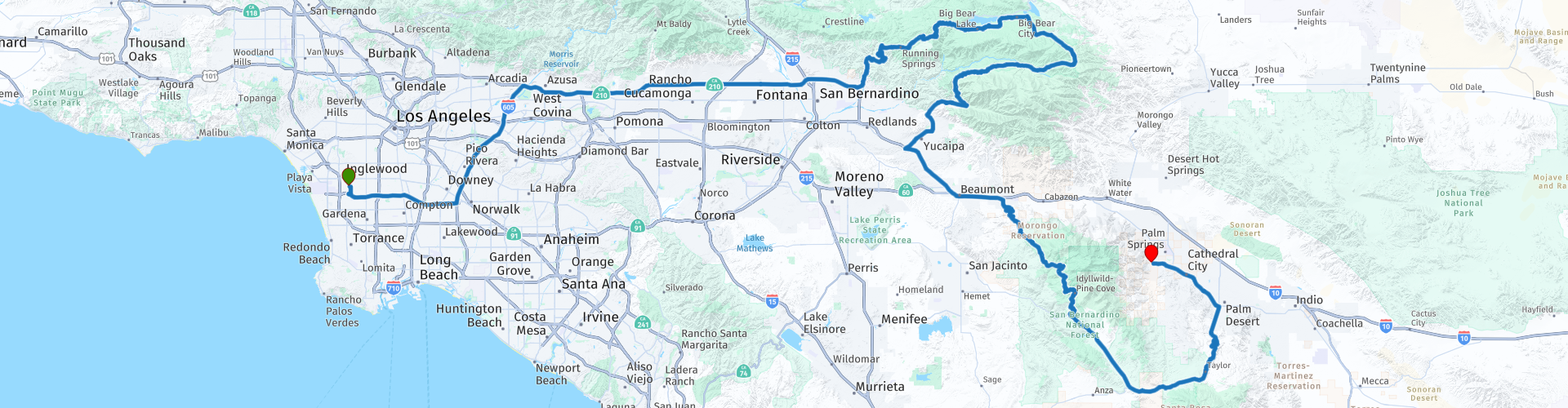
R01 Los Angeles Palm Springs

Cet itinéraire a été créé par:
RouteXpert Hans van de Ven (Mr.MRA)
Dernière modification: 29-12-2019
 Résumé de l'itinéraire
 Au cours de ce voyage, vous traverserez les États suivants: Californie, Arizona, Utah et Nevada.
Les routes sont bonnes, la région vallonnée et boisée et les vues magnifiques, de la ville animée de Los Angeles à l'exclusif Palm Springs!
Point de départ: Tradewinds Airport Hotel
Point d'arrivée: Best Western Inn à Palm Springs.
L'itinéraire a été identique pour les utilisateurs de navigation TomTom, Garmin et MyRoute-app.
Merci à Richard & Lisa pour l'information!
 Partager cet itinéraire


Animation

Verdict


Durée
5h 47m

Mode de déplacement
Voiture ou moto

Distance
411.54 km

Pays

 RouteXpert Review
 Après avoir récupéré votre moto le jour de votre arrivée et l'avoir garée dans le parking de l'hôtel, vous pourrez profiter de Los Angeles pour le reste de la journée et éventuellement visiter Sunset Boulevard. Le lendemain, votre voyage commence à Califormia. Avec les vélos emballés et emballés avec des bagages, nous quittons Los Angeles. La 1ère partie de l'itinéraire n'est pas la plus attrayante, car Los Angeles est une série de villes, donc elle sera assez occupée, vous pouvez maintenant vous habituer à vous habituer aux motos et à conduire en Amérique. Astuce: Essayez de planifier votre voyage de manière à emprunter cet itinéraire un samedi, il sera alors moins chargé!
Lorsque nous avons laissé Los Angeles derrière nous, nous quittons l'autoroute et nous nous dirigeons vers la forêt nationale de San Bernardino, afin de pouvoir diriger pendant un certain temps et nous ne sommes pas sur l'autoroute toute la journée. La forêt nationale de San Bernardino est une zone boisée et vallonnée où les californiens recréent souvent. La superficie est de 823 816 acres (3 333,87 km2). Les hauteurs varient de 2000 à 11 499 pieds (600 à 3505 m). Des plans ont également été réalisés pour les films suivants: Daniel Boone en 1936 & Paint Your Wagon en 1969.
À Bear Lake, nous avons le premier arrêt de gaz du voyage, les 180 premiers kilomètres sont là-dessus et nous nous arrêtons pour le déjeuner au restaurant Pines Lakefront, où vous pourrez prendre un délicieux déjeuner avec vue sur le lac.
Lorsque nous avons quitté cette zone, nous recherchons un morceau d'autoroute pour ne pas arriver trop tard à Palm Springs. Mais d'abord, nous nous arrêtons à l'Indian Vista Overlook, où, si vous êtes chanceux, vous pourrez voir des cerfs, des lynx roux, des renards gris ou un coyote. Vous faites également un arrêt à Coachella Valley Vista, où vous avez une vue fantastique sur Bighorn Country Club, Palm Desert, Indian Wells et La Quinta, également la vue sur les montagnes San Jacinto et San Gorgonio est super, et sur une belle clair jour, vous pouvez voir la pointe nord de la mer de Salton, qui est à environ quarante miles au sud-est.
Un tel premier jour est bien sûr de s'habituer au moteur et à la température, car vous vous arrêterez régulièrement c'est tout à fait un sit. Une fois à Palm Springs, où vous pouvez vous arrêter au supermarché avant d'arriver à l'hôtel et vous devez absolument faire le plein, afin que le lendemain, vous puissiez repartir avec un réservoir plein. Une fois à l'hôtel, vous pourrez nager dans la piscine de l'hôtel. Il y a aussi toutes sortes de magasins, de magasins d'alimentation et de boissons dans le "centre-ville" de Palm Springs.
Dans cet itinéraire 4 étoiles, vous roulerez sur de belles bonnes routes, à travers une zone boisée avec diverses opportunités pour prendre de belles photos d'ensemble.
Des renseignements généraux:
Le fleuve Colorado couvre la majeure partie de la califomie centrale du sud. Dans ce désert apparemment aride se trouvent deux vallées vertes: la vallée impériale, qui borde le Mexique, et plus au nord la vallée de Coachella. En 1901, le fleuve Colorado a été détourné par un réseau de canaux pour irriguer ces deux régions. Les deux vallées produisent des cultures telles que la laitue, les tomates, les agrumes, les melons et les dattes en hiver. Ici, dans ce bassin irrigué de la vallée de Coachella - la capitale mondiale de la datte - se trouve Palm Springs.
En traversant les vallées, vous rencontrerez un certain nombre de tours étranges le long de l'autoroute. Ces éoliennes utilisent l'énergie éolienne pour produire de l'électricité. Les moulins à vent sont un phénomène assez récent; ils sont construits par des sociétés d'investissement qui tentent de vendre de l'énergie éolienne à des sociétés de services publics. La loi californienne stipule que les compagnies d'électricité locales doivent acheter toute l'énergie produite par des particuliers. Il y a deux autres parcs éoliens en Californie, qui sont également situés dans des endroits venteux. À l'heure actuelle, il y a plus de 10 000 moulins à vent dans toute la Californie.
Palm Springs est une véritable oasis dans le désert. La ville doit son nom d'une part à la présence du palmier indigène de Washington, et d'autre part aux nombreuses sources chaudes. Pendant des siècles, la région de Palm Springs a accueilli des tribus indiennes, qui ont fondé de petits villages autour des nombreuses sources de la vallée. Les Indiens Agua Caliente - qui possèdent toujours la majorité de Palm Springs passaient l'hiver à Palm Springs et passaient les mois d'été dans les montagnes plus fraîches de San Bemardino. Cette tribu (le nom espagnol Agua Caliente signifie simplement eau chaude) est l'une des rares tribus indiennes vraiment riches aux États-Unis. Beaucoup des impressionnantes demeures de Palm Springs sont construites sur des terres louées par l'Aqua Calientes.
En 1870, Palm Springs devint un arrêt le long d'une importante voie ferrée, le Southern Pacific Railroad. Dans les années 1920 et 1930, le cadre magnifique et le climat chaud du désert ont attiré un certain nombre de grandes stars hollywoodiennes à Palm Springs. Cette tradition se poursuit aujourd'hui, et maintenant non seulement des célébrités, mais d'autres Américains aisés arrivent. Palm Springs est une résidence secondaire pour de nombreuses stars de cinéma. Même un ancien maire de Palm Springs, Sonny Bono, était autrefois un artiste célèbre. La plupart des visiteurs viennent à Palm Springs pour se reposer et se détendre, mais il existe également un certain nombre d'attractions populaires.
Le tramway aérien de Palm Springs fait une montée de 1800 mètres et mène à la forêt de la montagne San Jacinto, où se trouve le parc d'État du mont San Jacinto. Le voyage ne prend que 20 minutes, mais d'une manière merveilleuse, il vous emmène de l'air sec du désert à l'air frais de la montagne. Il y a aussi une vue spectaculaire sur le désert. Les trois canyons indiens voisins - Palm, Andreas et Murphy - offrent une oasis de tranquillité, avec d'agréables sentiers de randonnée et des aires de pique-nique.
Le tramway aérien est payant. (Remarque: le trajet en téléphérique n'est pas adapté aux personnes ayant des hauteurs). Pour rejoindre le téléphérique, prenez la sortie Tramway Road avant d'arriver à Palm Springs. Pour les personnes qui préfèrent quelque chose d'un peu plus lent, il y a le Palm Springs Desert Museum dans la ville. Le musée présente des expositions très variées, avec des œuvres de Matisse ainsi que des trésors du Far West. Il est situé au 101 Museum Drive.
Une promenade tranquille sur l'exclusif Palm Canyon Drive est également agréable. Il y a beaucoup de beaux restaurants et boutiques exclusives sur cette large avenue bordée de palmiers.


 Liens
Liens  Utilisation
 Vous voulez télécharger cette route?
Vous pouvez télécharger l'itinéraire gratuitement sans compte MyRoute-app. Pour ce faire, ouvrez l'itinéraire et cliquez sur 'enregistrer sous'. Vous voulez éditer cette route?
Pas de problème, commencez par ouvrir la route. Suivez le tutoriel et créez votre compte personnel MyRoute-app. Après l'enregistrement, votre essai démarre automatiquement.  Avertissement
L'utilisation de cet itinéraire GPS est à vos propres frais et risques. L'itinéraire a été soigneusement composé et vérifié par un RouteXpert accrédité par MyRoute-app pour une utilisation sur TomTom, Garmin et MyRoute-app Navigation.
Des modifications peuvent néanmoins s'être produites en raison de circonstances modifiées, de déviations de routes ou de fermetures saisonnières. Nous vous recommandons donc de vérifier chaque itinéraire avant de l'utiliser.
Utilisez de préférence le tracé de l'itinéraire dans votre système de navigation. Plus d'informations sur le l'utilisation de MyRoute-app peut être trouvée sur le site Web sous 'Communauté' ou 'Académie'