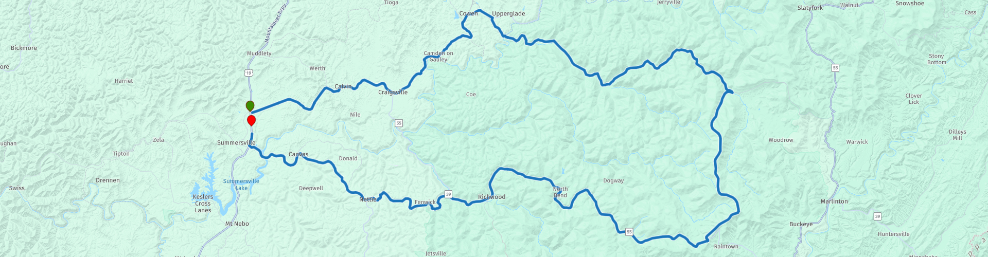
Round trip from Summersville via Highland Scenic Highway

Questo percorso è stato creato da:
RouteXpert Nick Carthew - (MRA Master)
Ultima modifica: 31-01-2023
 Riepilogo percorso
 Ho suggerito di fare un picnic da gustare al Cranberry Mountain Nature Center.
Lo scenario e le strade sono molto buoni con buone attrazioni che fanno guadagnare a questo percorso 4 **** stelle.
 Condividi questo percorso


Animation

Verdetto


Durata
3h 15m

Modalità di viaggio
Auto o moto

Distanza
174.80 km

Paesi

 Revisione RouteXpert
 Entrerai nella foresta nazionale di Monongahela dopo aver attraversato il fiume Gauley e poi seguendo il fiume Williams a monte di Donaldson per 22 miglia. La splendida cornice del fiume Williams, insieme al suo facile accesso e al sano habitat del torrente, lo rendono uno dei migliori torrenti per la pesca alla trota dello stato. A partire da Black Mountain nella contea di Pocahontas, questo fiume continua a scorrere per 33 miglia a ovest per fondersi con il fiume Gauley a Donaldson. I villaggi di Donaldson, Dyer e Three Forks of Williams River sono le uniche comunità nominate lungo il suo corso remoto.
Due risorse nello spartiacque di Williams erano il legname e il carbone, sviluppati nel periodo successivo alla guerra civile. Nel 1890, i tronchi venivano fatti galleggiare lungo il fiume nei flussi primaverili fino a un mulino a Camden-on-Gauley. La maggior parte del legname nello spartiacque Williams è stato portato via con un treno di tronchi dal 1905 al 1940 circa, ai mulini di Marlinton e Richwood. L'attività di estrazione del carbone è continuata sulla Williams inferiore negli anni '70. L'isolamento e l'asprezza che hanno ostacolato l'insediamento dello spartiacque hanno permesso alla maggior parte di esso di tornare a uno stato quasi originario dopo il legname, e oggi forse il suo valore più importante è per la ricreazione.
Lascerai il fiume Williams e ti unirai alla Highland Scenic Highway.
Nel cuore dei monti Appalachi si trova la Highland Scenic Highway, che offre uno dei percorsi di montagna più spettacolari della nazione.
Essendo un'area isolata con abbondanti risorse naturali, la natura selvaggia della Highland Scenic Highway è stata uno dei primi rifugi per gli americani che cercavano di evitare gli orrori della guerra civile. Le famiglie che si trasferirono nella zona in questo periodo mantennero il loro isolamento per decenni. Negli anni '60, i discendenti di queste famiglie ricevettero la visita di persone che facevano ricerche per lo Smithsonian Institution. Mentre i ricercatori studiavano e registravano le storie orali delle famiglie in quest'area, scoprirono che la lingua parlata era ancora l'inglese elisabettiano dei primi coloni statunitensi!
Passerai due punti panoramici che ti esorto a fermarti per una foto. Il Big Spruce Overlook e il Williams River Overlook hanno entrambi una vista eccezionale.
Il Cranberry Mountain Nature Center è il prossimo ed è un ottimo posto dove fermarsi per il tuo picnic.
Al centro puoi conoscere la ricca flora e fauna della Cranberry Wilderness Area e anche delle Cranberry Glades e delle Hills Creek Falls. È possibile visitare le Glades e le cascate a breve distanza lungo questo percorso. Le caratteristiche del centro includono programmi interpretativi, giardino di fiori selvatici nativi, serpenti vivi, esposizioni interpretative, articoli e abbigliamento legati alla natura in vendita, sentieri, tavoli da picnic, eventi e programmi per bambini. Non ci sono costi per programmi, eventi e ingressi.
Dopo pranzo, a solo 1/2 miglio dal centro, puoi svoltare a destra per visitare Cranberry Glades 1 1/2 miglia lungo la Public Road 102.
L'area botanica di Cranberry Glades protegge la più vasta area di torbiere del West Virginia. Le torbiere sono zone umide acide che si trovano più comunemente nelle aree settentrionali di questo paese e in Canada. Il terreno in una palude è spugnoso ed è costituito in gran parte da materiale vegetale parzialmente in decomposizione noto come torba. A causa delle sue condizioni uniche, alcune piante insolite crescono nelle paludi, comprese le piante carnivore o insettivore. L'area botanica comprende 750 acri. Le Cranberry Glades sono costituite da quattro paludi la cui vita vegetale e animale è simile a quella che si trova nelle paludi o "muskegs" del nord. La storia naturale delle Glades risale ad almeno 12.200 anni fa. Apparentemente, una foresta di latifoglie settentrionali di conifere ha sostituito la tundra con la fine dell'ultima era glaciale. Nel corso del tempo le Glades si sono formate in quello che sono oggi, le Cranberry Glades sono ora il punto più meridionale del Nord America dove si trovano alcune di queste forme di vita.
Una passerella di mezzo miglio è stata costruita attraverso due delle paludi in modo che tu possa goderti l'area senza disturbare questa fragile comunità. Merita una visita.
5 minuti più avanti lungo la Highland Scenic Highway e vedrai un cartello e svoltare a sinistra per le cascate di Hills Creek:
Una serie di tre cascate precipita su strati rocciosi di arenaria e scisto, 20 piedi, 45 piedi e la terza caduta di 65 piedi, rendendo questa cascata una delle più alte del West Virginia. Le cascate di Hills Creek sono il gioiello scintillante nella corona della foresta nazionale di Monongahela.
La passerella accessibile ai disabili è lunga 1.700 piedi e consente a tutti di vedere la prima cascata. I rododendri e l'alloro fioriscono sotto l'ombra del baldacchino. La prima caduta scende di 25 piedi, schiantandosi sulle rocce sottostanti.
Proseguire fino alla seconda cascata attraverso un sentiero sterrato e una serie di gradini in legno. A 45 piedi di altezza e molto più largo della prima caduta, inizi ad apprezzare la bellezza naturale di Hills Creek mentre il torrente precipita e rotola su massi ricoperti di muschio. Per gli appassionati di fiori selvatici, il tappeto forestale è vivo con oltre 40 specie di fioriture, principalmente in primavera fino all'inizio dell'estate.
La passerella sterrata, intervallata da rocce e piccoli massi, prosegue fino alla terza e ultima cascata. Il viaggio dal parcheggio alle cascate inferiori è di oltre tre quarti di miglio. Verso la fine, il sentiero sterrato si trasformerà in gradini di metallo lungo una serie di tornanti fino al belvedere. La splendida vista della caduta di 65 piedi vale ogni passo del cammino. Dalla caduta più alta alla caduta più bassa, il Creek scende di 220 piedi.
Due ponti di osservazione offrono un'ottima posizione per scattare fotografie o semplicemente rilassarsi e divertirsi.
Ritorna sulla Highland Scenic Highway e inizierai a seguire il percorso della North Fork of Cherry River.
Le sorgenti superiori del Cherry iniziano come due torrenti separati, il North Fork Cherry River e il South Fork Cherry River, ciascuno dei quali sorge nella contea sud-orientale di Pocahontas e scorre generalmente verso ovest-nord-ovest attraverso la contea settentrionale di Greenbrier prima di convergere nella contea di Nicholas a la città di Richwood.
Puoi scegliere di uscire dalla Highland Scenic Highway per visitare Summit Lake, una piccola deviazione di 2 1/4 miglia.
Summit Lake è un serbatoio di acqua fredda di 43 acri nel distretto di Gauley Ranger della foresta nazionale di Monongahela. Il serbatoio è formato dall'arginamento delle acque di due forcelle di Coats Run, un piccolo affluente del North Fork del Cherry River. In periodi di siccità, quando il fiume Cherry diventa troppo basso, il lago può essere utilizzato per rifornire il sistema idrico municipale di Richwood.
Richwood è il prossimo ed è la fine della magnifica Highland Scenic Highway.
Durante il XIX secolo, la piccola comunità agricola di Richwood era conosciuta come Cherry Tree Bottoms. Tutto cambiò nel 1901 con la costruzione della segheria The Cherry River Boom and Lumber Company. Nello stesso anno la città fu incorporata con il nome attuale che fa riferimento alle abbondanti foreste di latifoglie della zona. La popolazione è passata da 25 persone a 4.400 in pochi anni, rendendo Richwood una vera e propria città del boom.
Al massimo delle operazioni, il mulino impiegava oltre 1.000 lavoratori e produceva 270.000 piedi di tavola di legname al giorno. L'enorme successo del mulino attirò nella zona altre industrie legate al legno. Nel 1901, la Dodge Clothes Pin Company costruì a Richwood la più grande fabbrica di mollette da bucato del mondo. L'anno successivo, The Cherry River Tanning Company costruì una conceria molto grande, attratta dalle grandi quantità di corteccia di Hemlock di proprietà della Cherry River Boom and Lumber Company.
Nel corso degli anni il mulino ha cambiato più volte proprietà e la produzione e l'occupazione sono diminuite costantemente. La produzione al mulino è stata sospesa per un periodo di tempo e gli orgogliosi lavoratori e cittadini di Richwood hanno sofferto. Tuttavia, nel 2021, AFP Log and Lumber Incorporated ha acquistato lo stabilimento e ha riaperto le operazioni per la gioia della gente di Richwood.
A Fenwick, svolta a sinistra sul fiume Cherry e segui la strada tortuosa fino al punto di partenza a Summersville.
Divertiti.


 Collegamenti
  Utilizzo
 Vuoi scaricare questo percorso?
Puoi scaricare il percorso gratuitamente senza un account MyRoute-app. Per farlo, apri il percorso e fai clic su 'Salva con nome'. Vuoi modificare questa rotta?
Nessun problema, inizia aprendo il percorso. Segui il tutorial e crea il tuo account MyRoute-app personale. Dopo la registrazione, la tua prova inizia automaticamente.  Disclaimer
L'utilizzo di questo percorso GPS è a tue spese e rischio. Il percorso è stato accuratamente composto e controllato da un RouteXpert accreditato dall'app MyRoute per l'utilizzo su TomTom, Garmin e navigazione dell'app MyRoute.
Ciononostante potrebbero essersi verificati cambiamenti a causa di mutate circostanze, deviazioni stradali o chiusure stagionali. Si consiglia pertanto di controllare ciascun percorso prima dell'uso.
Utilizzare preferibilmente la tracklog del percorso nel sistema di navigazione. Maggiori informazioni sul l'uso dell'app MyRoute può essere trovato sul sito Web in 'Community' o 'Academy'.

Virginia Occidentale
Informazioni su questa regione
La Virginia Occidentale (West Virginia in inglese) è uno Stato federato degli Stati Uniti d'America, situato nella regione degli Appalachi, negli Stati Uniti d'America orientali. Confina con la Virginia a sud-est, con il Kentucky a sud-ovest, con l'Ohio a nord-ovest, con la Pennsylvania a nord e con il Maryland a nord-est. La Virginia Occidentale è il 41º stato per superficie e il 38° più popoloso tra i 50 stati. La capitale e maggiore città è Charleston.
Divenne uno stato a seguito della Convenzione di Wheeling, in cui 50 contee nord-occidentali della Virginia i cui proprietari terrieri possedevano pochi o nessuno schiavo, decisero di separarsi dalla Virginia durante la guerra di secessione statunitense. Il nuovo stato fu ammesso all'Unione il 20 giugno 1863 e divenne un importante stato cuscinetto fra Unione e Confederazione. La Virginia Occidentale è stato l'unico stato a costituirsi separandosi da uno degli Stati Confederati e uno dei due stati formatisi durante la guerra di secessione (l'altro è il Nevada, separatosi dal Territorio dello Utah).
Il Census Bureau e l'Associazione dei Geografi Statunitensi classificano la Virginia Occidentale come parte del Sud; il panhandle settentrionale si estende presso Pennsylvania e Ohio, con le città di Wheeling e Weirton, appena oltre il confine dell'area metropolitana di Pittsburgh, mentre Bluefield è a meno di 110 km dalla Carolina del Nord. Huntington, nel sud-ovest, è vicina agli stati di Ohio e Kentucky, mentre Martinsburg e Harper's Ferry, nel panhandle orientale, sono considerati parte dell'area metropolitana di Washington, tra gli stati di Maryland e Virginia. La particolare posizione della Virginia Occidentale la rende inclusa in diverse regioni geografiche, tra cui il Medio Atlantico, l'Alto Sud e il Sud-Est. È l'unico stato che è interamente all'interno dell'area servita dalla Commissione Regionale degli Appalachi, la zona comunemente definita "Appalachia".Lo stato è conosciuto per le sue montagne, per le sue industrie di legname e di estrazione del carbone, molto importanti a livello storico, oltre che per la sua politica e storia del lavoro. È una delle aree del mondo più dense per quanto riguarda il carsismo, il che la rende area privilegiata per le ricerche scientifiche e per le escursioni; le terre carsiche contribuiscono molto alla presenza di trote di acqua dolce. La Virginia Occidentale è anche molto conosciuta per una vasta gamma di opportunità ricreative, tra cui lo sci, il rafting, la pesca, la caccia, il mountain biking e l'escursionismo.
Leggi di più su Wikipedia
Divenne uno stato a seguito della Convenzione di Wheeling, in cui 50 contee nord-occidentali della Virginia i cui proprietari terrieri possedevano pochi o nessuno schiavo, decisero di separarsi dalla Virginia durante la guerra di secessione statunitense. Il nuovo stato fu ammesso all'Unione il 20 giugno 1863 e divenne un importante stato cuscinetto fra Unione e Confederazione. La Virginia Occidentale è stato l'unico stato a costituirsi separandosi da uno degli Stati Confederati e uno dei due stati formatisi durante la guerra di secessione (l'altro è il Nevada, separatosi dal Territorio dello Utah).
Il Census Bureau e l'Associazione dei Geografi Statunitensi classificano la Virginia Occidentale come parte del Sud; il panhandle settentrionale si estende presso Pennsylvania e Ohio, con le città di Wheeling e Weirton, appena oltre il confine dell'area metropolitana di Pittsburgh, mentre Bluefield è a meno di 110 km dalla Carolina del Nord. Huntington, nel sud-ovest, è vicina agli stati di Ohio e Kentucky, mentre Martinsburg e Harper's Ferry, nel panhandle orientale, sono considerati parte dell'area metropolitana di Washington, tra gli stati di Maryland e Virginia. La particolare posizione della Virginia Occidentale la rende inclusa in diverse regioni geografiche, tra cui il Medio Atlantico, l'Alto Sud e il Sud-Est. È l'unico stato che è interamente all'interno dell'area servita dalla Commissione Regionale degli Appalachi, la zona comunemente definita "Appalachia".Lo stato è conosciuto per le sue montagne, per le sue industrie di legname e di estrazione del carbone, molto importanti a livello storico, oltre che per la sua politica e storia del lavoro. È una delle aree del mondo più dense per quanto riguarda il carsismo, il che la rende area privilegiata per le ricerche scientifiche e per le escursioni; le terre carsiche contribuiscono molto alla presenza di trote di acqua dolce. La Virginia Occidentale è anche molto conosciuta per una vasta gamma di opportunità ricreative, tra cui lo sci, il rafting, la pesca, la caccia, il mountain biking e l'escursionismo.
Visualizza regione
 Statistiche
  8
8Quantità di recensioni RX (Virginia Occidentale)
 1441
1441Quantità di visitatori (Virginia Occidentale)
 44
44Quantità di download (Virginia Occidentale)
 Indirizza le collezioni in questa regione
 Il viaggio su strada definitivo negli Stati Uniti, parte 05
Michel van Hagen mi ha sfidato a seguire il Roadtrip del Dr. Randy Olsen come base per creare l'Ultimate USA Road Trip per l'app MyRoute RouteXpert Library. Ho raccolto questa sfida e ho iniziato a febbraio 2022.
Lo scienziato Dott. Randy Olsen, divenuto noto per aver utilizzato la sua conoscenza degli algoritmi per trovare "Waldo" nella famosa serie di libri americani "Where's Waldo", è stato sfidato da Tracy Staedter, di Discovery News, a utilizzare lo stesso algoritmo per creare il perfetto Road Trip creando gli Stati Uniti, che visiterà quasi tutti gli stati degli Stati Uniti. Alaska e Hawaii non sono incluse in questo Road Trip a causa della loro posizione geografica.
Alla base del percorso c'erano i seguenti tre requisiti: in tutti i 48 paesi deve esserci almeno una sosta in punti famosi, monumenti, siti storici, parchi nazionali, ecc. Ho aggiunto ulteriori punti interessanti, bellissimi tour e percorsi.
Dopo più di 26 mesi, il lavoro è terminato e, con il grande supporto di Nick Carthew, ho creato 129 rotte che attraversano 48 stati degli Stati Uniti e parte del Canada. Questa è la quinta raccolta che ti porta da Cocao Beach in dieci giorni attraverso la Florida, la Georgia, la Carolina del Sud e la Virginia fino a Kill Devil Hills nella Carolina del Nord.
Visualizza raccolta percorsi