De meren en almen van Karinthie vanuit Villach

Questo percorso è stato creato da:
RouteXpert Hans van de Ven (Mr.MRA)
Ultima modifica: 11-02-2023
 Riepilogo percorso
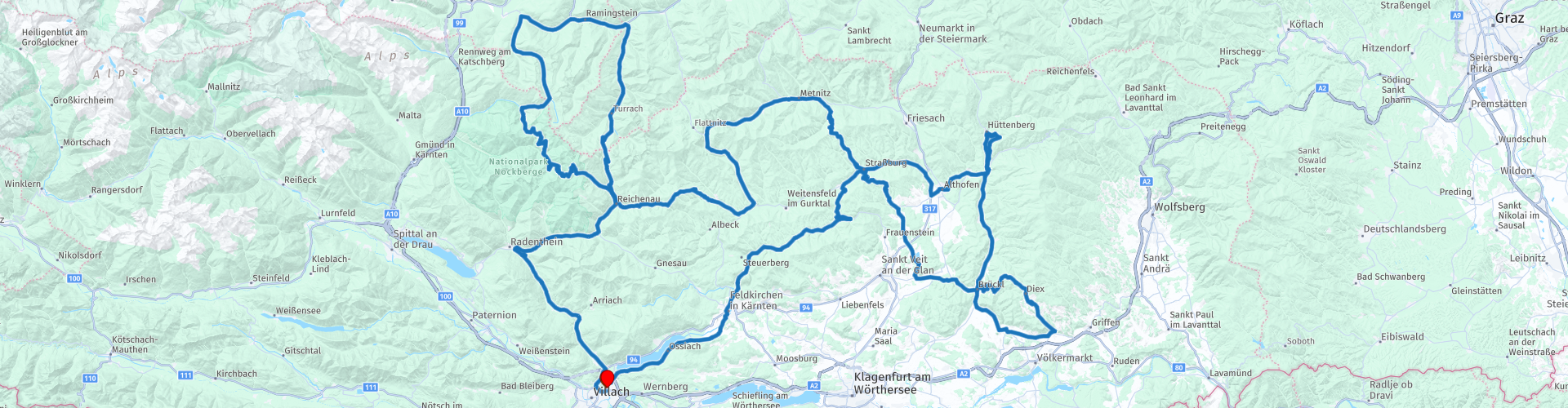
 Inizio: Villaco
Finitura: Villach
Il percorso ha fatto lo stesso per gli utenti TomTom, Garmin e MyRoute-app Navigation.
Se vuoi guidare questo TT, tieni a mente le informazioni seguenti:
- Nessuna esperienza in montagna
- Tour
- Sistemazione necessaria
- Tol
Fonte: Promoter 07, settembre / ottobre 2018.
 Condividi questo percorso


Animation

Verdetto


Durata
7h 27m

Modalità di viaggio
Auto o moto

Distanza
415.66 km

Paesi

 Revisione RouteXpert
 - Passi e strade di montagna: Nockalmstraße (Eisentalhöhe 2042 m), Turracher Höhe (1783 m)
- Chiusura invernale: la Nockalmstraße è l'unica strada di montagna a tutto tondo che viene regolarmente chiusa durante il periodo invernale da metà novembre ai primi di maggio.
- Pedaggio: Nockalmstraße
- Percorsi alternativi: da Innerkrems a Gmünd per visitare il Museo Porsche di Helmut Pfeifhofer. A Diex con la chiesa più imponente di Kärnten e passato Burg Hochosterwitz.
- Mesi ideali: la Carinzia ha un clima mite a causa di tutti i laghi. Ecco perché la primavera e l'autunno sono l'ideale per un viaggio. In estate è particolarmente occupato. L'unico finanziatore è la Nockalmstraße, con le sue chiusure invernali.
- Motore: nessuna restrizione
- Strade: strade strette ma fattibili. Vale anche per la strada in parte non asfaltata ma ben mantenuta per Hochrindl.
- Piacere di guida: in primo luogo, la Nockalmstraße, nonostante il limite di velocità, la strada offre puro piacere automobilistico. Il percorso nel suo insieme è ricco di molte curve.
- Paesaggio: il Nockalm. Durante la pedalata sull'Hochrindl ti verranno presentate splendide viste.
Questo itinerario a 5 stelle è uno dei 24 percorsi alpini più belli degli ultimi anni!
Punti del percorso colorati:
rp 1 - Punto di partenza da Villach al Jugendhotel Egger
rp 7 - Fermata del caffè sull'Eisentalhöhe, punto di vista delle femmine e passaggio.
rp 8 - Schönfeldsattel
rp 12 - Pranzo al Biker Treffpunkt
rp 13 - Opzione serbatoio
rp 16 - Prekowa
rp 17 - Possibilità di alloggio presso Krainer "Das Herrenhaus"
rp 23 - Fermata del caffè a Rabl
rp 29 - Arresto del serbatoio su Shell
rp 36 - Pranzo a Kreuzwirt
rp 40 - End point a Villach presso Jugendhotel Egger


 Collegamenti
  Utilizzo
 Vuoi scaricare questo percorso?
Puoi scaricare il percorso gratuitamente senza un account MyRoute-app. Per farlo, apri il percorso e fai clic su 'Salva con nome'. Vuoi modificare questa rotta?
Nessun problema, inizia aprendo il percorso. Segui il tutorial e crea il tuo account MyRoute-app personale. Dopo la registrazione, la tua prova inizia automaticamente.  Disclaimer
L'utilizzo di questo percorso GPS è a tue spese e rischio. Il percorso è stato accuratamente composto e controllato da un RouteXpert accreditato dall'app MyRoute per l'utilizzo su TomTom, Garmin e navigazione dell'app MyRoute.
Ciononostante potrebbero essersi verificati cambiamenti a causa di mutate circostanze, deviazioni stradali o chiusure stagionali. Si consiglia pertanto di controllare ciascun percorso prima dell'uso.
Utilizzare preferibilmente la tracklog del percorso nel sistema di navigazione. Maggiori informazioni sul l'uso dell'app MyRoute può essere trovato sul sito Web in 'Community' o 'Academy'.