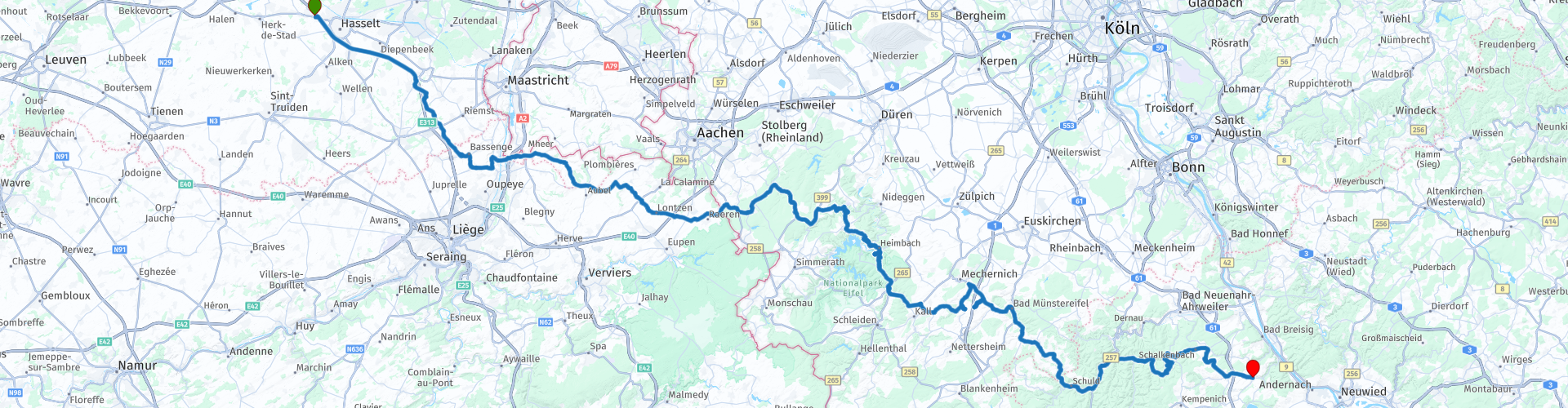
From Hasselt to Burgbrohl in the Eifel

Questo percorso è stato creato da:
RouteXpert Guy Heyns - Sr RouteXpert
Ultima modifica: 10-12-2024
 Riepilogo percorso
 Il percorso vi conduce attraverso le zone rurali del Limburgo meridionale direttamente nello splendido paesaggio della regione di Voer, dopo di che visiterete il Parco Naturale delle High Fens. Quindi in realtà ti immergi nelle riserve naturali abbastanza rapidamente.
Il percorso è un omaggio ed è adatto anche al ciclista alle prime armi, anche se il ciclista esperto non si annoierà sicuramente su questo percorso verso un hotel super deluxe dove è molto piacevole soggiornare....
Cibo (gustoso) per tutti, ed è per questo che questo percorso merita sicuramente una valutazione di 5 stelle!
 Condividi questo percorso


Animation

Verdetto


Durata
5h 46m

Modalità di viaggio
Auto o moto

Distanza
238.62 km

Paesi


 Revisione RouteXpert
 Burgbrohl, la meta del nostro viaggio, si trova nella regione dell'Eifel occidentale, al confine tra l'Hoch-Eifel e le montagne dell'Ahr, quasi al confine con il Reno e il Westerwald. Ciò rende questo viaggio molto interessante mentre attraversi l'intera catena montuosa dell'Eifel nel tuo percorso.
Questo percorso inizia a Hasselt in un ampio parcheggio dove è facile e sicuro incontrarsi. Puoi anche incontrarti al chiuso se le condizioni meteorologiche sono deludenti.
Il percorso vi porta brevemente sull'autostrada in direzione di Bilzen, dove oltrepassate Alden Biezen, un imponente castello del Limburgo dove vengono organizzati numerosi eventi. L'incantevole paesaggio ondulato del Limburgo meridionale ti porta poi in direzione del Voerstreek, un altro gioiello della corona fiamminga. Anche se la zona si trova in Vallonia, è e rimane una zona fiamminga. È tutto molto illogico, ma è tipicamente belga...
Manterremo breve una storia molto lunga dicendo che, se avete familiarità con i contrasti fiamminghi-valloni, la regione del Voer è una regione sulla quale è stato versato molto inchiostro (e sangue) nella lotta fiammingo-vallone. Questa battaglia è ancora in corso, anche se oggi è più nell’arena politica. Ma comunque altrettanto stronzo.....
Comunque... il passaggio attraverso la regione del Voer conduce attraverso le High Fens fino alla zona dell'Eifel e ciò significa che la maggior parte di questo percorso attraversa bellissime riserve naturali. Troverete sicuramente maggiori informazioni a riguardo nei link allegati.
L'Eifel è una bellissima zona. Se si tiene conto anche del fatto che si tratta di una piccola ma vera zona di montagna, attraversata dalle strade asfaltate tedesche di alta qualità, allora non credo che sia necessario fare altri disegni. È chiaro che l'Eifel è giustamente una zona molto apprezzata dai motociclisti (e non solo).
Questo percorso è effettivamente un percorso di avvicinamento all'Eifel, ma anche il percorso stesso vale il "viaggio". Questo percorso soddisferà ogni tipo di ciclista nonostante questa classificazione di approccio. Tecnicamente è carino e facile da fare per il principiante, mentre il professionista esperto non si annoierà di certo. Non mancano le curve e le svolte, varie con tratti meravigliosi e splendidi panorami attraverso le varie riserve naturali. Molta varietà su questo percorso e qualcosa per tutti!
L'hotel all'arrivo è un hotel super-deluxe con ogni lusso per il ciclista più viziato. Quindi anche dopo l'arrivo potrete continuare a divertirvi, anche se l'autista puritano storcerà il naso. Nessun problema, il giardino è abbastanza grande per la sua tenda...


 Collegamenti
  Utilizzo
 Vuoi scaricare questo percorso?
Puoi scaricare il percorso gratuitamente senza un account MyRoute-app. Per farlo, apri il percorso e fai clic su 'Salva con nome'. Vuoi modificare questa rotta?
Nessun problema, inizia aprendo il percorso. Segui il tutorial e crea il tuo account MyRoute-app personale. Dopo la registrazione, la tua prova inizia automaticamente.  Disclaimer
L'utilizzo di questo percorso GPS è a tue spese e rischio. Il percorso è stato accuratamente composto e controllato da un RouteXpert accreditato dall'app MyRoute per l'utilizzo su TomTom, Garmin e navigazione dell'app MyRoute.
Ciononostante potrebbero essersi verificati cambiamenti a causa di mutate circostanze, deviazioni stradali o chiusure stagionali. Si consiglia pertanto di controllare ciascun percorso prima dell'uso.
Utilizzare preferibilmente la tracklog del percorso nel sistema di navigazione. Maggiori informazioni sul l'uso dell'app MyRoute può essere trovato sul sito Web in 'Community' o 'Academy'.

Provincia di Liegi
Informazioni su questa regione
La provincia di Liegi (in francese Province de Liège /ljɛ:ʒ/, in olandese Provincie Luik /lœʏ̯k/, in tedesco Provinz Lüttich /'lʏtɪç/, in vallone Province di Lidje) è la provincia più orientale della Vallonia, una delle tre regioni del Belgio. Confina con i Paesi Bassi (Limburgo), con la Germania (Renania Settentrionale-Vestfalia e Renania-Palatinato) a est, con il Granducato di Lussemburgo a sud e con le province belghe del Lussemburgo a sud, di Namur a sud-ovest, del Brabante Vallone a ovest, del Brabante Fiammingo e del Limburgo a nord. Il capoluogo è Liegi. Occupa una superficie di 3.844 km² ed è divisa in quattro distretti amministrativi (arrondissement in francese) che contengono 84 comuni.
Leggi di più su Wikipedia
Visualizza regione
 Statistiche
  75
75Quantità di recensioni RX (Provincia di Liegi)
 41527
41527Quantità di visitatori (Provincia di Liegi)
 19121
19121Quantità di download (Provincia di Liegi)
 Indirizza le collezioni in questa regione
 I 10 percorsi automobilistici e motociclistici più belli del Limburgo
Limburgo, chi pensa al Limburgo, pensa al flan, alle miniere di carbone, alla marna e alle colline. Le miniere di carbone sono chiuse da quasi 40 anni, l'ultimo carico di carbone è stato portato dalla miniera di carbone Oranje-Nassau a Heerlen il 31 dicembre e, come si dice, il Limburgo meridionale è stato trasformato da nero a verde e purtroppo c'è ancora poco a sinistra vista di questo periodo.
Ma non solo torta, marna e carbone nel Limburgo, ma anche una bellissima provincia da visitare in auto o in moto e godere di tutta la bellezza che la provincia del Limburgo ha da offrire. Per questo, l'app MyRoute RouteXpert ha messo insieme per te una Top 10 di percorsi per auto e moto.
Tutti i percorsi di questa raccolta sono stati verificati e resi uguali per TomTom, Garmin e la navigazione dell'app MyRoute da un RouteXpert dell'app MyRoute.
Se pensi che ho un percorso molto carino che di certo non dovrebbe mancare in questa raccolta, invialo a:
e-mail: routeexpert@myrouteapp.com
Oggetto: Nuovo percorso per la collezione Top 10 Provincia del Limburgo composta da Hans van de Ven.
Il percorso verrà quindi rivisto e poi aggiunto alla Top 10.
Per entrare nella Top 10 anche la Top 10, 1 percorso dovrà scomparire dalla Top 10, puoi indicarlo al momento dell'invio del nuovo percorso.
Divertiti con questa raccolta e mentre guidi uno di questi percorsi. Goditi tutta la bellezza che i Paesi Bassi e in particolare la provincia del Limburgo hanno da offrire. Clicca su “Visualizza percorso” per leggere la recensione del percorso scelto.
Vorrei conoscere le vostre conclusioni sui percorsi.
Visualizza raccolta percorsi
I 5 migliori percorsi per auto e moto nell'Eifel
L'Eifel è la parte orientale del medio altopiano Eifel-Ardenne. Si trova a nord della Mosella e ad ovest del Reno. La maggior parte è in Germania, una piccola parte è in Belgio, nei cantoni orientali. La parte tedesca dell'Eifel si trova negli stati federali del Nord Reno-Westfalia e della Renania-Palatinato. Il punto più alto è l'Hohe Acht con 747 metri.
Diverse catene possono essere distinte nell'Eifel:
La parte più settentrionale è chiamata Nordeifel, che in Belgio si collega alle Alte Paludi;
Ad est di questo c'è l'Ahrgebirge, questa parte si trova a nord dell'Ahr nel distretto di Ahrweiler;
A sud dell'Ahr si trova l'Hohe Eifel (o Hocheifel), di cui l'Hohe Acht (747 m) è il punto più alto, nonché il punto più alto dell'intera regione dell'Eifel;
A ovest, vicino al confine belga, le colline sono conosciute come Schneifel, parte della più ampia area dello Snow Eifel con cime che raggiungono i 698 metri;
A sud e ad est dell'Hohe Eifel si trova il Volcano-Eifel, un'area vulcanica con molti laghi vulcanici (Maare).
La parte meridionale dell'Eifel è meno alta. L'area è attraversata da torrenti e fiumi che scorrono verso sud. Questi flussi sfociano nella Mosella. Il più grande di questi fiumi è il Kyll; le colline intorno a questo fiume sono conosciute come il Kyllwald;
A sud, l'Eifel finisce nel Voreifel.
Nel nord dell'Eifel ci sono alcuni grandi serbatoi. Il più grande di questi è il bacino idrico del Roer, creato dalla costruzione della diga del Roerdal.
Il Nürburgring si trova anche nell'Eifel, un noto circuito automobilistico per le gare di Formula 1, tra le altre cose. Dal 2004, parte del nord dell'Eifel è diventato il Parco nazionale dell'Eifel. Questo parco nazionale rientra interamente nel parco naturale tedesco-belga High Fens-Eifel. Un'altra parte dell'Eifel rientra nel Parco naturale dell'Eifel meridionale.
Conosciuto in tutti i Paesi Bassi e in Belgio in auto e in moto, quindi un motivo sufficiente per l'app MyRoute RouteXpert per compilare una Top 5 di percorsi per auto e moto per te.
Tutti i percorsi di questa raccolta sono stati verificati e resi uguali per TomTom, Garmin e la navigazione dell'app MyRoute da un RouteXpert dell'app MyRoute.
Se pensi che ho un percorso molto carino che di certo non dovrebbe mancare in questa raccolta, invialo a:
email: routeexpert@myrouteapp.com
Oggetto: Nuovo percorso per la collezione Top 5 Eifel composta da Hans van de Ven.
Il percorso verrà quindi rivisto e poi aggiunto alla Top 5. Per entrare nella Top 5 anche la Top 5, 1 percorso dovrà scomparire dalla Top 5, è possibile indicarlo al momento dell'invio del nuovo percorso.
Divertiti con questa collezione e mentre guidi uno di questi percorsi. Goditi tutta la bellezza che l'Eifel ha da offrire. Clicca su “Visualizza percorso” per leggere la recensione del percorso scelto.
Vorrei conoscere le vostre conclusioni sui percorsi.
Visualizza raccolta percorsi