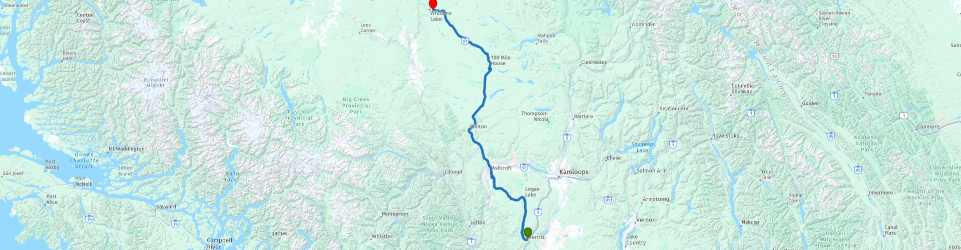
D02 Merritt Williams Lake

Questo percorso è stato creato da:
RouteXpert Hans van de Ven (Mr.MRA)
Ultima modifica: 24-10-2021
 Riepilogo percorso
 Le strade sono molto buone, i dintorni sono molto belli e 100 Mile House è un bellissimo patrimonio con una natura meravigliosa.
Punto di partenza: Quality Inn Merritt
Punto finale: Best Western-Williams Lake
Il percorso è stato reso lo stesso per gli utenti di navigazione TomTom, Garmin e MyRoute-app.
Grazie a Richard e Lisa per l'informazione!
 Condividi questo percorso


Animation

Verdetto


Durata
3h 48m

Modalità di viaggio
Auto o moto

Distanza
319.06 km

Paesi

 Revisione RouteXpert
 Restiamo fino ad Ashcroft sul 97C, dove puoi fermarti un momento per fare rifornimento e avere qualcosa da mangiare o da bere. Dopo Ashcroft prendiamo la Highway 97 (Cariboo Highway), che ci porta nella cittadina di 100 Mile House, che è circondata da centinaia di laghi, zone umide e altre zone umide che la rendono un paradiso per gli uccelli. 100 Mile House era un tempo luogo di sosta per cercatori d'oro. Dieci minuti a nord di 100 Mile House è un museo a cielo aperto con l'eredità di 108 Mile. Qui ci sono edifici storici del periodo della corsa all'oro del diciannovesimo secolo, tra cui una baita, un ufficio postale, un capannone e un vecchio edificio scolastico.
La Cariboo Road corre lungo 100 Mile House. Questa strada fu posata per i diecimila cercatori d'oro che visitarono l'interno della British Columbia nel diciannovesimo secolo. Stavano andando a Barkerville, situato nella regione di Cariboo. A breve distanza dalla 100 Mile House si trova il Centennial Park, che offre i sentieri escursionistici necessari. Guarda le Bridge Creek Falls, una cascata che scorre su antiche formazioni di lava.
In questo percorso a 4 stelle percorrerai belle strade, attraverso un ambiente mozzafiato e la fermata al 100 Mile House ne vale sicuramente la pena.
storia:
100 Mile House, precedentemente chiamata Bridge Creek House, serviva come luogo dove trascorrere la notte per cercatori d'oro che viaggiavano nella regione del Cariboo. Thomas Miller è stato uno dei primi residenti di Bridge Creek House. Possedeva una serie di edifici che servivano da deposito per le pellicce e le pelli in cui commerciava. 100 Mile House ricevette il nome attuale durante la corsa all'oro del Cariboo. Molti dei villaggi sulla vecchia strada Cariboo - il percorso che i cercatori d'oro presero nella regione interna del Cariboo - furono indicati dalla distanza dal punto di partenza del percorso: Lillooet (0 miglia). Lo stesso vale per 100 Mile House, che si trova a 100 miglia a nord di Lillooet. Il punto finale era Fort Alessandria. Questo percorso era già stato utilizzato nel 1859 dalla Hudson's Bay Company.
Una parte di questo percorso sarebbe stata inclusa alcuni anni dopo nella Cariboo Wagon Road, che Yale aveva come punto di partenza meridionale. A Clinton, la Old Cariboo Road e la Cariboo Wagon Road si unirono per continuare a Fort Alexandria. La nuova Cariboo Road proseguì da lì verso Quesnel e la Barkerville orientale. Per questo motivo, sia Lillooet che Yale sono chiamati "miglio zero".
Tra il 1862 e il 1870, oltre 10.000 persone percorsero la Cariboo Road da Lillooet a Fort Alexandria. 100 Mile House divenne un punto di sosta e un punto di rifornimento a metà del percorso. Alla fine della corsa all'oro, gli agricoltori e gli allevatori di bestiame si stabilirono attorno a 100 Mile House.


 Collegamenti
  Utilizzo
 Vuoi scaricare questo percorso?
Puoi scaricare il percorso gratuitamente senza un account MyRoute-app. Per farlo, apri il percorso e fai clic su 'Salva con nome'. Vuoi modificare questa rotta?
Nessun problema, inizia aprendo il percorso. Segui il tutorial e crea il tuo account MyRoute-app personale. Dopo la registrazione, la tua prova inizia automaticamente.  Disclaimer
L'utilizzo di questo percorso GPS è a tue spese e rischio. Il percorso è stato accuratamente composto e controllato da un RouteXpert accreditato dall'app MyRoute per l'utilizzo su TomTom, Garmin e navigazione dell'app MyRoute.
Ciononostante potrebbero essersi verificati cambiamenti a causa di mutate circostanze, deviazioni stradali o chiusure stagionali. Si consiglia pertanto di controllare ciascun percorso prima dell'uso.
Utilizzare preferibilmente la tracklog del percorso nel sistema di navigazione. Maggiori informazioni sul l'uso dell'app MyRoute può essere trovato sul sito Web in 'Community' o 'Academy'.