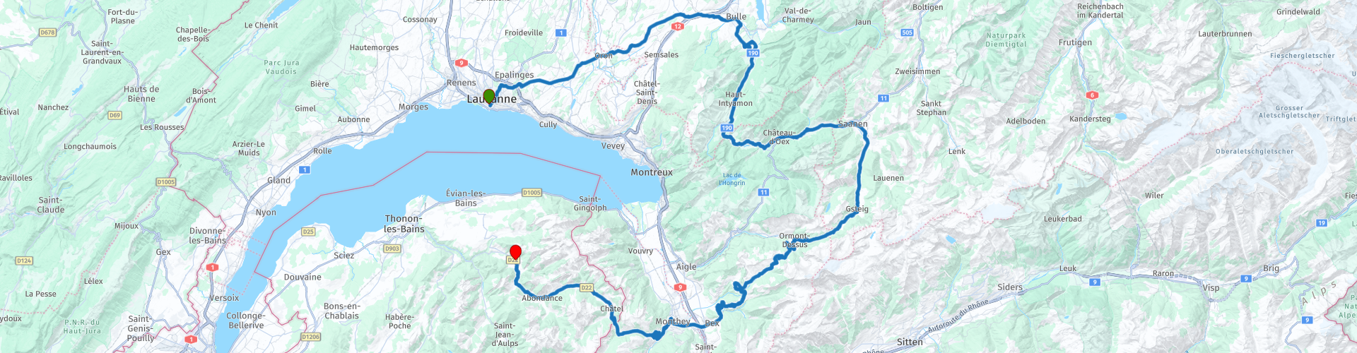
Across country borders 01 Lausanne to Vacheresse over the Morgins Pass

This route was brought to you by:
RouteXpert Catherine De Groote RouteXpert
Last edit: 26-02-2024
 Route Summary
 The start in Lausanne on Lake Geneva alone offers beautiful views. France and three Swiss cantons share the famous water, whose coastline is one of the most beautiful in Europe.
No less impressive are the individual towns and villages you drive through. BulIe, in the heart of the Gruyère district, and Cluses, in the Arve Valley in the French Alps, are as historic as they are picturesque. This also applies to Monthey, the city on the Vièze. In between, in touristy Saanen and in Gstaad, the typical chalet architecture surprises: it belongs to Switzerland, just like skyscrapers belong to New York.
A true highlight among the Alpine passes is the Pas de Morgins, which connects Switzerland with France. The Col de la Forclaz - between the Rhone Valley and Chamonix - is also an important transport link. Chamonix is famous as the location of the first Winter Olympics in 1924. On the Swiss side you mainly see vineyards, in France dense green forests dominate the landscape. The mighty, usually snow-capped Mont-Blanc is almost always in sight. At the Col du Grand Saint-Bernard (Great St. Bernard Pass), take the road over the pass: you cannot miss the beauty of this border area between Switzerland and Italy.
This route in the border area of Switzerland and France promises many beautiful things. Lausanne on Lake Geneva offers beautiful views. You will pass some historic towns such as Bulle, Saane and Gstaad. The Pas de Morgins is located on the border of Switzerland and France. The road to the top is a real highlight: endless bends and loops with impressive views. The road surface is in top condition throughout the entire ride. No doubt this ride deserves 5 stars.
 Share this route


Animation

Verdict


Duration
8h 14m

Mode of travel
Car or motorcycle

Distance
185.39 km

Countries


 RouteXpert Review
 Did you know that it takes the water of the Rhône about eleven years to flow from east to west through Lake Geneva! Another fact: with 580 km², this is the largest lake in Switzerland.
The city's landmark, in Lake Geneva, can be seen from a distance. Because the large fountain 'Jet d'eau' sprays up to 140 m high. The fountain was built in 1885 as a pressure relief valve for a hydroelectric power station, but became a world-famous tourist attraction in 1891. A curious fact: the fountain is turned on by hand every morning; retired employees of Geneva's municipal utilities control and monitor its operation.
Hotel Carlton in Lausanne is the starting point of this ride. After 5 km you have left the city behind you and find yourself in the middle of nature.
The Route d'Oron leads to the heart of the Gruyère district. The 13th century Oron Castle was the former residence of the Bern bailiff from 1557 to 1798. The castle's apartments (kitchen, music room, hunting room, prior's room, etc.) are open to the public and there are several pieces of furniture from the 17th and 18th centuries, as well as paintings, crockery, etc. The old library contains 18,000 books. Visitors can also walk across the walkway under the castle's roof and climb to the top of the keep.
It continues to the picturesque Bulie. This beautifully preserved historic town is known for the Schloss Vogtei from the 13th century, the Saint-Pierre-aux-Liens church from the 9th century and the Notre-Dame-de-Compassion chapel from 1688. It is located in the impressive landscape of the Freiburg Alps. Bulle is known for its folklore and livestock markets that attract a diverse audience.
Surrounded by a beautiful mountain panorama and with beautiful streets, a chocolate factory and an impressive medieval castle complex, Gruyères seems to confirm all the Swiss clichés.
To reach the castle of Gruyères you leave the route. The medieval complex houses beautiful collections that bear witness to a long, rich history. A visit to the castle is like a journey through time, with treasures waiting to be discovered: precious stained glass from the Middle Ages, knight's cloaks, wall decorations commissioned by the governors under the ancien régime and the decoration of the knights' hall by a passionate artists' colony in the 19th century.
You now return along the same road. You pass Lake Lessoc via the gentle bends of the Route de l'lntyamon. The surface of the lake is 20 hectares. The Lessoc Dam with a height of 33 m was completed in 1976. The lake is silting up with 40,000 m³ of alluvium per year and if nothing is done, it should be filled in by 2035.
A little further you pass Lake Vernex. It is a reservoir on the Saane/Sarine river near Rossinière. It is located at an altitude of 859 m above sea level, between the Pointe de Cray and Planachaux mountains.
After Château-d'Oex you get a beautiful view of the mountains of the Alpes Vaudoises. You continue to follow the course of the Sarine until Saanen.
Tradition and craftsmanship give what is probably the most beautiful chalet village in the Bernese Oberland its charm. Narrow streets and alleys lead to the village center, with wooden houses from the 15th to the 18th century. In the 1950s, a law stipulated that the typical character of the region had to be preserved. In other words: new construction projects next to the many original chalets must be adapted to the traditional architecture. In addition to Saanen, this region has nine other chalet villages, the highest of which is at almost 1400 m.
Despite all the luxury, Gstaad has remained down to earth. 'No one comes here to be seen. If you want that, go to Sankt Moritz or Zermatt', is the unofficial opinion of the residents of Gstaad, which is over 1000 m high. And they are rich. Very rich, to be precise: mainly old nobility. But many celebrities also come to enjoy the peace and quiet. During a walk through the streets you will encounter something of the traditions of Saanenland at every corner, as the region around Saanen and Gstaad is called. That gives the village a special flair. The landscape is no less magical.
The Gsteigstrasse leads on a straight road to Gsteig and then via a few beautiful bends to the Route du Pillon.
The road over the Col du Pillon (1546 m) connects Gsteig with Aigle in the Rhone Valley. The winding, well-maintained road is fun, although the top of the pass offers few views and is entirely developed for tourism. However, if you get off your bike and continue on foot, you will be rewarded with a varied landscape of rocks and ice, with a priceless panorama of the Wadtländer and Valais Alps. In the immediate vicinity you can see the 3123 m high Oldenhorn, in the southwest the famous four-thousanders Mont-Blanc and Dents du Midi and in the southeast the Matterhorn.
The town of Les Diablerets is a stronghold of adventure sports. The rock walls of the mountain massif, which surround the small village in the Ormont Valley, were considered cursed in the Middle Ages. The devil is said to have done his mischief here: hence the name of the mountain range, which translates as 'devil's horns'. The Cabane des Diablerets mountain hut is the starting point to the glacial mountains, whose main peak, the Sommet des Diablerets, reaches a height of 3210 m. Even in summer the glacier is a snow paradise, which has recently been enriched with a spectacular attraction: the Peak Walk, a 107 m long suspension bridge that connects two mountain peaks.
Once you are firmly back in the saddle, you ride southwest to the 1778 m high Col de la Croix and the Rhône Valley. Not only do you have a beautiful view at the top, but also during the climb and descent. Strange rock formations rise along the road, the 'Pyramides de Gypse': they are formed by erosion of gypsum rock. In winter the road is closed to traffic and is used as a toboggan run - very spectacular.
Monthey, on the Vièze, had many rulers for years, until the city finally gained political independence in 1352. Nowadays it is the tolerant attitude to life of the more than 17,500 inhabitants of the most diverse origins that contributes to the lively and harmonious cityscape. Located in the Chablais region, the town has some historic buildings, such as the Chateau de Monthey, with its arcaded courtyard. But Monthey is best known for the Théâtre du Crochetan - far beyond the borders of the canton - and for the carnival that has been around for a century.
At Monthey there are two bridges over the Vièze river: an old wooden bridge from the time of Napoleon (1809) and a new, spectacular bridge that spans the gorge. The steel frame is 90 m long, hangs at a height of 60 m and offers a dazzling view of the peaceful, unspoilt nature and the wild gorge.
After Monthey you drive via the village of Troistorents to the Morgins ski area, which is located on a plateau, not far from the border with France.
After a few bends you soon reach altitude. After passing Morgins and the customs posts, the route eventually leads to the Pas de Morgins, which connects the French department of Haute-Savoie and the Swiss canton of Valais. The border runs over the top, where there is a small chapel. The eastern slope proves why this road has been a real highlight among the Alpine passes since 1870: endless bends and loops invite you to push your bike uphill. Still on the Swiss side you pass a small lake, the Lac de Morgins. On the French side the road is less spectacular.
You stay in the valley of La Dranse d'Abondance. Just outside Abondance you will find the Maison du Fromage Val d'Abondance.
Set off on a sensory discovery tour of landscapes, techniques and senses in 9 phases. Here time is no longer divided into fragments, but unfolds in richness. Cow breeds, milk, mountain huts, production stages, ripening, labels and the different cheeses from Savoie are all discussed. From the tasting table, your senses are stimulated to appreciate all the subtleties of Abondance cheese!
The end point of this first stage is in Vacheresse. The chambres d'hôtes Au Petit Bonheur is located in the heart of the village. The restaurant, which is only open to hotel guests, offers traditional cuisine and specialties such as the delicious and famous potato fritters accompanied by cold cuts from the mountains. You can enjoy a beautiful panoramic view of the valley and the surrounding mountains. There are 5 guest rooms, an outdoor terrace and lounge. There is also free parking.


 Links
Links  Usage
Usage Want to download this route?
You can download the route for free without MyRoute-app account. To do so, open the route and click 'save as'. Want to edit this route?
No problem, start by opening the route. Follow the tutorial and create your personal MyRoute-app account. After registration, your trial starts automatically.  Disclaimer
Use of this GPS route is at your own expense and risk. The route has been carefully composed and checked by a MyRoute-app accredited RouteXpert for use on TomTom, Garmin and MyRoute-app Navigation.
Changes may nevertheless have occurred due to changed circumstances, road diversions or seasonal closures. We therefore recommend checking each route before use.
Preferably use the route track in your navigation system. More information about the use of MyRoute-app can be found on the website under 'Community' or 'Academy'.

Bern
About this region
Bern (German: [bɛrn] (listen); Alemannic German: Bärn [b̥æːrn]) or Berne (French: [bɛʁn] (listen); Arpitan: Bèrna [ˈbɛʁna] (listen); Italian: Berna [ˈbɛrna]; Romansh: Berna [ˈbɛrnɐ] (listen)) is the de facto capital of Switzerland, referred to by the Swiss as their "federal city" (in German: Bundesstadt, French: ville fédérale, and Italian: città federale). With a population of about 144,000 (as of 2020), Bern is the fifth-most populous city in Switzerland. The Bern agglomeration, which includes 36 municipalities, had a population of 406,900 in 2014. The metropolitan area had a population of 660,000 in 2000.Bern is also the capital of the canton of Bern, the second-most populous of Switzerland's cantons. The official language is German, but the main spoken language is the local variant of the Alemannic Swiss German dialect, Bernese German. In 1983, the historic old town (in German: Altstadt) in the centre of Bern became a UNESCO World Heritage Site.
Read more on Wikipedia
View region
 Statistics
  29
29Amount of RX reviews (Bern)
 20305
20305Amount of visitors (Bern)
 1975
1975Amount of downloads (Bern)
 Route Collections in this region
 The 24 Most Beautiful Alpine Routes
The Alps, The Alps are a mountain range in Europe, stretching from the French Mediterranean coast in the southwest to the Pannonian Plain in the east. The area of the mountain range is more than 200,000 km².
In other words Passes and Mountain Roads!
Driving through the mountains is great! Especially over the mountain passes with hairpin bends and narrow winding roads. Every bend a different view where you can enjoy. There are many beautiful mountain passes in the Alps.
A selection that has also been incorporated into these routes:
The Stlevio Pass:
The Stelvio Pass, also known as Passo dello Stelvio, is mainly known for the stage in the Giro d'Italia. Due to the length and the difference in height, this pass is seen as one of the toughest tests in cycling. The Stelvio Pass reaches a maximum height of 2758 meters and is therefore one of the highest in the Alps. The pass connects the towns of Bormio and Prato Allo Stelvio. In winter the pass is closed due to heavy snowfall.
The Reschenpass:
The Reschenpass, also known as Passo di Resia, connects the Austrian state of Tyrol with the Italian province of South Tyrol. The pass reaches a maximum height of 1,504 meters and has been one of the most important north-south connections in the Alps in recent centuries. The pass was used long before Roman times. Along the way you will pass several highlights and historical relics. One of the highlights is the Reschensee. This lake was created after the construction of the dam and has completely submerged the village of Graun. The only thing that reminds of that is the clock tower in the middle of the lake.
Col du Galibier:
The French mountain pass Col du Galibier connects the towns of Saint-Michel-de-Maurienne and Briançon via the Col du Lautaret in the south and the Col du Télégraphe in the north. The mountain pass is part of the Tour de France and very much feared, due to the fact that it can only be reached via the other two mountain passes. The pass reaches a maximum height of 2646 meters. From there you can take a walk to the viewpoint at 2704 meters. You can admire the peaks of the Grand Galibier, Mont Blanc and La Meije here.
The Grossglockner High Alpine Road:
With a height of 3798 meters the Grossglockner is the highest mountain in Austria. To fully enjoy this impressive mountain, you can drive over the Grossglockner High Alpine Road and the accompanying pass. The route starts from Bruck am Grossglockner and ends in Heiligenblut. Of course you can drive in two directions. The pass reaches a maximum height of 2504 meters and is closed in winter due to heavy snowfall. Along the way you pass several stops with fun activities, information points, mountain huts and viewpoints. A visit to the Kaiser-Franz-Josefs-Höhe and Pasterzen Glacier is highly recommended.
The Col d'Izoard:
Just like the Col du Galibier, the Col d'Izoard is also part of a stage of the Tour de France. The mountain pass connects Briançon with the valley of the river Guil. The pass is partly located in the Regional Natural Park du Queyras and reaches a maximum height of 2360 meters. What is special about the Col d'Izoard is the barren and rocky landscape. Sometimes it feels like driving a car over the moon! Along the way you can stop at several points to enjoy the beautiful view.
The Bernina Pass:
The Bernina Express is one of the most famous rail trains in Switzerland and the Alps. The route is beautiful and partly included on the UNESCO World Heritage List. Parallel to the railway lies the Bernina pass, which connects the Veltlin valley with the Egandin valley. This beautiful Alpine road has a total length of 56 kilometers and reaches a maximum height of 2328 meters. Along the way you can enjoy views of the Morteratsch Glacier.
The Sella Pass:
The Sella Pass, also known as Passo di Sella, takes you over one of the most impressive mountain ranges in the Dolomites: the Sella massif. The pass connects Valle di Fassa with Val Gardena and reaches a maximum height of 2236 meters. At this height is also the border of the Italian provinces of Trentino and Bolzano. Along the way you can enjoy the view of this spectacular mountain world. Admire, for example, the three peaks of the Sasso Lungo massif, the Sella massif or the peaks of the Marmolada. You can also drive the Sella pass in combination with the Gardena pass, Pordoi pass and Campolongo pass.
The Grimsel Pass:
The Grimsel Pass connects Goms in Wallis with the Halis Valley in the Bernese Oberland. The pass reaches a maximum elevation of 2165 meters and is closed in winter due to snowfall. Over the centuries, the mountain pass has played an important role in trade between Switzerland and Italy. Now it is mainly the reservoirs that have an important function. These are used to generate electricity. The landscape you drive through is rugged, rocky and impressive. On top of the pass is a hotel and a restaurant with a special marmot park. The Dodensee (Totensee) is also located here. This lake owes its name to the many soldiers who died in the time of Napoleon.
The Gotthard Pass:
The Gotthard Pass, also known as Passo del San Gottardo and Saint Gotthard, connects the Swiss towns of Airolo and Andermatt. The mountain pass and associated tunnel are especially known among holidaymakers driving from Switzerland to Italy. But where the majority opt for the tunnel, it is precisely the pass that really completes the holiday. The Gotthard Pass has a length of about 26 kilometers and reaches a maximum height of 2106 meters. The route is beautiful and takes you along old villages and beautiful views.
The Silvretta High Alpine Road and Silvretta Pass:
The Paznaun Valley in Tyrol and the Montafon in Vorarlberg are connected by the Silvretta High Alpine Road. The route has a length of 22.3 kilometers and leads from Galtür to Partenen in 34 hairpin bends, via the 2032 meter high Bielerhöhe. The Silvrettasee is also located at this point, where you can enjoy a lovely walk. The pass is closed in winter due to snowfall.
The Simplon Pass:
Just like the Gotthard Pass, many holidaymakers also travel over the Simplon Pass every year. This mountain pass connects the Rhone Valley in the canton of Valais with the Valle d'Ossola in Piemonte. The pass is open all year round and reaches a maximum height of 2005 meters. Along the way you pass a number of buildings, including the well-known Simplon Hospiz from 1825. The hospiz is managed by the monks of St. Bernard. From the highest point on the pass, all kinds of hiking routes are possible and you will also come across a hotel where you can spend the night.
The Gerlos Pass:
The Gerlos Pass connects the Salzach Valley in the Salzburgerland with the Zillertal Valley in Tyrol. The pass is part of the Gerlos Alpenstraße and runs right through the Hohe Tauern National Park. Along the way you can enjoy beautiful views of the surroundings. The pass has a length of 12 kilometers and reaches a maximum height of 1531 meters. A ride over the Gerlos Pass can be ideally combined with a visit to the Krimmler Wasserfälle.
The Great St. Bernard Pass:
The Great St. Bernard Pass, better known as Col du Grand Saint Bernard, connects the Italian province of Valle d'Aosta with the Swiss canton of Valais. The pass is one of the highest in Switzerland and reaches a maximum height of 2469 meters. Like a number of other mountain passes in this list, the Great St. Bernard Pass has also been used as a connecting road for centuries. The pass is named after the St. Bernard dogs that used to help stranded travelers along with the monks. The pass is closed in winter.
The Timmelsjoch High Alpine Road:
The Timmelsjoch High Alpine Road connects the towns of Sölden in the Ötztal and Meran in South Tyrol. Tolls must be paid on the Hochgurgl - Moos route. Via a mountain road with about 60 hairpin bends you drive through a beautiful mountain world. With the Timmelsjoch Experience you can learn more about the history, the road and the environment via various stations. You can also visit the Top Mountain Crosspoint museum.
Col de l'Iseran:
With a maximum pass height of 2770 meters, the Col l'Iséran is one of the highest mountain passes in the Alps. The pass connects Bourg-Saint-Maurice with Bonneval-sur-Arc. Via a road full of hairpin bends you pass, among other things, Val-d'Isère and a side valley of the Maurienne that lies entirely in the National Park de la Vanoise. You can spot animals such as marmots and chamois and there is also a restaurant with a chapel on top of the pass.
The Gavia Pass:
The Gavia Pass (Italian Passo di Gavia) is a mountain pass in the Italian Alps, in the Lombardy region.
It is one of the highest pass roads in Europe. The road leads through the unspoilt Stelvio National Park. The road was built in the First World War to supply Italian soldiers who fought in the Italian-Austrian border area. The pass height is one of the most beautiful in the Alps. Here is the large Lago Bianco with, to the north, the mountain San Matteo (3684 meters). Lago Nero is slightly lower on the south side of the pass. Here the mountain group of the Adamello determines the view. There are many well-marked walks in the area. During the winter the pass is closed due to the heavy snowfall. The pass is often closed until May and June due to the large amount of snow.
Promoter has made a selection of the 24 Most Beautiful Alpine routes that they have set out in recent years.
The routes go through:
France
Austria
Switzerland
Italy
The most beautiful roads, the most beautiful views, the most beautiful viewpoints. The highest mountains, the fastest descents, hairpin bend after hairpin bend, you name it you can't get enough of it.
If you go on holiday in this region, take advantage of it, ALL routes in this collection have been checked and made equal for TomTom, Garmin and MyRoute-app Navigation by a MyRoute-app RouteXpert.
Have fun with this collection and while driving one of these routes. Enjoy all the beauty that the Alps and the Dolomites have to offer. Click on “View route” to read the review of the chosen route.
I would like to hear your findings about the route(s).
View Route Collection
11 day trip from the Netherlands
8 countries in 11 days; The Netherlands, Germany, Austria, Italy, Switzerland, France, Luxembourg and Belgium. This route collections consists of 10 routes that I have driven with friends in the summer of 2019.
The start is in Geldermalsen Netherlands, the first 7 days you drive through the Netherlands, Germany, Austria, Italy, Switzerland, France and a piece of Luxembourg with overnight stays in hotels.
The last three days you stay in Barweiler (D) in the Eifel and you drive two beautiful tours through the Eifel, Luxembourg and parts of the Belgian Ardennes.
There is no highway in the routes, only beautiful provincial and country roads, many beautiful passes with beautiful panoramas.
Be sure to check whether the passes are open before you leave.
These are routes for experienced drivers.
View Route Collection