19 From Enkirch to Klimmen via the German Eifel

Cet itinéraire a été créé par:
RouteXpert Leonor Orban - Sr. RouteXpert
Dernière modification: 22-03-2021
 Résumé de l'itinéraire
 En cours de route, comme d'habitude en Moselle et dans l'Eifel, de merveilleuses randonnées sur des routes sinueuses sans fin. Les forêts sont entrecoupées de belles vues, qui montrent toute la beauté de ces réserves naturelles. Ici et là, vous avez la chance de visiter des châteaux (Burg Arras, Eulenburg et Wittem) et des vues sur le vieux village (Kronenburg) pour vous imprégner de l'atmosphère de ce qui était autrefois.
La bonne surface de la route, les randonnées détendues et les nombreuses occasions de faire une pause en cours de route font de cet itinéraire 4 étoiles.
 Partager cet itinéraire


Animation

Verdict


Durée
6h 28m

Mode de déplacement
Voiture ou moto

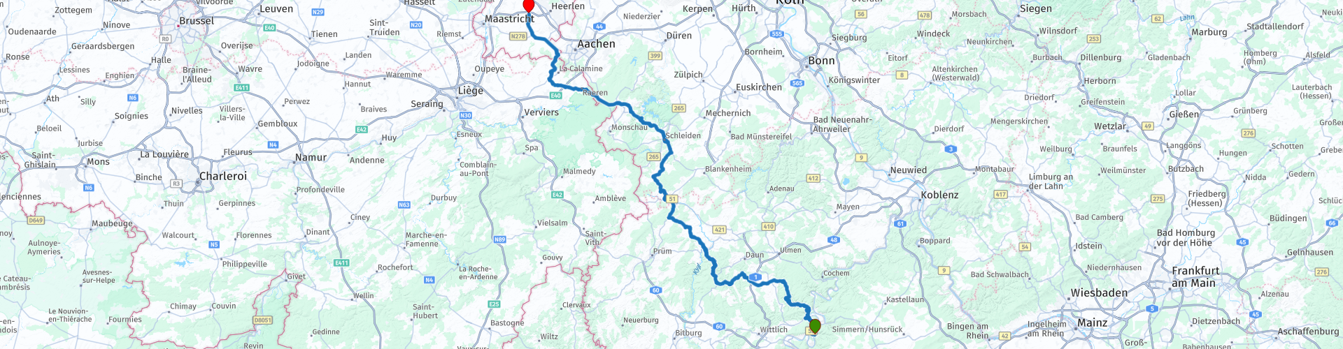
Distance
216.44 km

Pays


 RouteXpert Review
 Aujourd'hui, la 19e et dernière étape de la collecte des itinéraires vers l'Allemagne, l'Autriche, l'Italie, la Slovénie, la Croatie et la Bosnie-Herzégovine vous attend. Cet itinéraire est également basé sur un séjour de Marc Telkamp de 2015.
Après le petit déjeuner, vous sellez tous vos bagages sur la moto et le voyage vers les Pays-Bas commence. La première partie encore merveilleusement le long de la Moselle. Avec un peu de chance, vous verrez la vapeur du matin, éclairée par le soleil, remonter la rivière. La Moselle n'est que temporairement visible. Aujourd'hui, l'accent est mis sur le retour en voiture et qui sait ... y a-t-il un autre week-end mosellan à venir?
Heureusement, vous pouvez profiter de la Moselle pendant un moment en vous arrêtant au point de vue après Reil (rp 3) et en prenant quelques photos. De là, vous tournez vers l'ouest et commencez le trajet vers l'Eifel.
Pas beaucoup plus loin, vous passerez Burg Arras (rp 4). Si vous êtes intéressé, vous pouvez vous arrêter ici et admirer le château. Le bâtiment que vous voyez maintenant a été rénové au début des années 1900. En 1794, il a été sévèrement bombardé par l'armée française, qui a pratiquement détruit le château du 12ème siècle. Aujourd'hui, le château est un hôtel et un restaurant.
Après cette petite excursion, l'itinéraire se dirige vers Lutzerath. Ici, vous pouvez faire le plein à la station-service Ed (rp 6) et continuer vers l'un des nombreux maars de cette région. Vous pouvez vous garer sur le bord de la route et vous émerveiller devant l'énorme «trou dans le sol», le Pulvermaar (rp 7). L'Eifel est également souvent appelé l'Eifel volcanique en raison de l'activité volcanique dans le passé. De nos jours, vous pouvez en voir les traces sous la forme de mais. Un maar est une cavité en forme de bol ou d'entonnoir d'origine volcanique qui est submergée dans une zone terrestre pré-volcanique. Il a été formé par des explosions de vapeur d'eau lorsque l'eau souterraine et le magma chaud se sont rencontrés. Ceci s'applique également au Pulvermaar. Avec une profondeur de 72 mètres, ce n'est que le plus profond de la région.
Environ 2 heures après le départ, la première pause arrive à Gasthof Sünnen (rp 12). Même si vous voulez regarder autour de Kronenburg (à environ 15 minutes de route de Gasthof Sünnen), vous voudrez peut-être faire une pause maintenant. Il y a peu de restaurants dans le village de Kronenburg et donc souvent très fréquentés.
Kronenburg (rp 13) en lui-même est magnifique. Le centre médiéval vieux de 400 ans est compact. L'image du village est un grand monument de beaux bâtiments anciens, une chapelle, une église et un château. Le château lui-même est le seul à ne pas avoir survécu. Vous ne pouvez voir que la ruine. Si vous en avez envie et que vous avez le temps, il est recommandé de se garer à l'entrée du village et de faire une petite promenade.
De Kronenburg le voyage continue dans le Nordeifel, à la Rursee (rp 17). Le lac a été créé au début du XXe siècle après la construction d'un barrage. La zone était régulièrement inondée, nécessitant une solution à trouver. Grâce au lac et au barrage, l'eau peut désormais être mieux régulée dans la région. Un avantage supplémentaire est que le lac fournit également de l'eau potable et de l'électricité à la région. Il a également une énorme attraction pour les touristes. Il y a beaucoup à faire autour et autour du lac. C'est pourquoi nous roulons maintenant principalement le long du lac pour rester à l'écart de la foule. À Roetgen (rp 18), c'est un peu plus calme et vous pouvez choisir où vous voulez faire une pause. Un Strudel au Back Café Haus Heidbüchel ou une glace à Zamatteo? Alors encore un petit choix de stress le dernier jour de vos vacances!
Peu de temps après Roetgen, vous quittez l'Allemagne et une partie de l'itinéraire passe par la Belgique. Le paysage change et est régulièrement interrompu par les différents petits villages. En cours de route, vous pourrez également apercevoir le château d'Eulenburg (rp 20). Le château néo-gothique a été construit à la fin du 19ème siècle à partir d'une carrière de granit adjacente. Il est privé et ne peut donc être admiré que de la route.
Le château de Wittem (rp 23) peut être visité. Le château a été construit au 13ème siècle après que la noble famille Julemont a acheté la région. Ils ont également vécu longtemps dans ce château et y ont reçu diverses personnalités historiques. Aujourd'hui, ce château est aussi un hôtel avec restaurant (du nom des premiers habitants du château). Si vous avez encore un long trajet en voiture depuis la fin de la route, vous pouvez envisager de passer la nuit et de dîner ici généreusement.
Pour ceux qui continuent jusqu'à la fin de l'itinéraire, peuvent faire un dernier arrêt de ravitaillement à l'Avia (rp 24).
L'escalade apparaît lentement. Il y a quelques semaines, vos vacances ont commencé ici, vous vous êtes réunis avec impatience avec un certain nombre de compagnons de voyage, en prévision de ce que vous vivriez. Une fois de retour au Lunchroom Ice Cream Parlor Pleinzicht (rp 25), les invités sur la terrasse semblent inchangés, sauf pour vous et vos compagnons de voyage. Plein de nouvelles histoires, d'anecdotes et de riches souvenirs, vous vous asseyez ensemble sur la terrasse avec un sourire sur votre visage.


 Liens
Liens  Utilisation
 Vous voulez télécharger cette route?
Vous pouvez télécharger l'itinéraire gratuitement sans compte MyRoute-app. Pour ce faire, ouvrez l'itinéraire et cliquez sur 'enregistrer sous'. Vous voulez éditer cette route?
Pas de problème, commencez par ouvrir la route. Suivez le tutoriel et créez votre compte personnel MyRoute-app. Après l'enregistrement, votre essai démarre automatiquement.  Avertissement
L'utilisation de cet itinéraire GPS est à vos propres frais et risques. L'itinéraire a été soigneusement composé et vérifié par un RouteXpert accrédité par MyRoute-app pour une utilisation sur TomTom, Garmin et MyRoute-app Navigation.
Des modifications peuvent néanmoins s'être produites en raison de circonstances modifiées, de déviations de routes ou de fermetures saisonnières. Nous vous recommandons donc de vérifier chaque itinéraire avant de l'utiliser.
Utilisez de préférence le tracé de l'itinéraire dans votre système de navigation. Plus d'informations sur le l'utilisation de MyRoute-app peut être trouvée sur le site Web sous 'Communauté' ou 'Académie'

Rheinland Pfalz
À propos de cette région
La Rhénanie-Palatinat (en allemand : Rheinland-Pfalz, /ˈʁaɪ̯nlant ˈp͡falt͡s/ ) est l'un des seize États fédérés composant l'Allemagne.
Elle a été créée le 30 août 1946 à partir de la partie nord de la zone française d'occupation et légalement confirmée par un référendum sur le projet de constitution le 18 mai 1947. Le jour de constitution du land est célébré chaque année le 18 mai.
Le land compte environ 4 000 000 habitants, dont 317 000 étrangers, sur une surface de 19 848 km2 soit une densité de 203 hab./km2.
Située à l'ouest du pays, la Rhénanie-Palatinat est frontalière avec trois pays européens et quatre autres länder allemands (depuis le nord et dans le sens des aiguilles d'une montre) la Rhénanie-du-Nord-Westphalie, la Hesse, le Bade-Wurtemberg, la France, la Sarre, le Luxembourg et la Belgique (Région wallonne).
En savoir plus sur Wikipedia
Elle a été créée le 30 août 1946 à partir de la partie nord de la zone française d'occupation et légalement confirmée par un référendum sur le projet de constitution le 18 mai 1947. Le jour de constitution du land est célébré chaque année le 18 mai.
Le land compte environ 4 000 000 habitants, dont 317 000 étrangers, sur une surface de 19 848 km2 soit une densité de 203 hab./km2.
Située à l'ouest du pays, la Rhénanie-Palatinat est frontalière avec trois pays européens et quatre autres länder allemands (depuis le nord et dans le sens des aiguilles d'une montre) la Rhénanie-du-Nord-Westphalie, la Hesse, le Bade-Wurtemberg, la France, la Sarre, le Luxembourg et la Belgique (Région wallonne).
Afficher la région
 Statistiques
  141
141Nombre de critiques RX (Rheinland Pfalz)
 51799
51799Nombre de visiteurs (Rheinland Pfalz)
 28887
28887Nombre de téléchargements (Rheinland Pfalz)
 Acheminer les collections dans cette région
 Top 5 des itinéraires en voiture et en moto dans l'Eifel
L'Eifel est la partie orientale du moyen plateau Eifel-Ardennes. Elle est située au nord de la Moselle et à l'ouest du Rhin. La plus grande partie est en Allemagne, une petite partie est en Belgique, dans les Cantons de l'Est. La partie allemande de l'Eifel est située dans les États fédéraux de Rhénanie du Nord-Westphalie et de Rhénanie-Palatinat. Le point culminant est le Hohe Acht avec 747 mètres.
Plusieurs chaînes peuvent être distinguées dans l'Eifel :
La partie la plus septentrionale s'appelle le Nordeifel, qui en Belgique se raccorde aux Hautes Fagnes ;
A l'est se trouve l'Ahrgebirge, cette partie est située au nord de l'Ahr dans le quartier Ahrweiler ;
Au sud de l'Ahr se trouve le Hohe Eifel (ou Hocheifel), dont le Hohe Acht (747 m) est le point culminant, et aussi le point culminant de toute la région de l'Eifel ;
À l'ouest, près de la frontière belge, les collines sont connues sous le nom de Schneifel, faisant partie de la zone plus large de l'Eifel des neiges avec des sommets atteignant 698 mètres ;
Au sud et à l'est du Hohe Eifel se trouve le Volcan-Eifel, une zone volcanique avec de nombreux lacs de cratère (Maare).
La partie sud de l'Eifel est moins haute. La région est traversée par des ruisseaux et des rivières qui coulent vers le sud. Ces ruisseaux se jettent dans la Moselle. Le plus grand de ces fleuves est le Kyll ; les collines autour de cette rivière sont connues sous le nom de Kyllwald ;
Au sud, l'Eifel se termine dans le Voreifel.
Au nord de l'Eifel, il y a quelques grands réservoirs. Le plus grand d'entre eux est le réservoir de la Roer qui a été créé par la construction du barrage de Roerdal.
Le Nürburgring est également situé dans l'Eifel, un circuit automobile bien connu pour les courses de Formule 1, entre autres. Depuis 2004, une partie du nord de l'Eifel est devenue le parc national de l'Eifel. Ce parc national fait entièrement partie du parc naturel germano-belge Hautes Fagnes-Eifel. Une autre partie de l'Eifel fait partie du parc naturel du sud de l'Eifel.
Connu dans tous les Pays-Bas et la Belgique en voiture et en moto, c'est donc une raison suffisante pour que l'application MyRoute RouteXpert compile pour vous un Top 5 des itinéraires en voiture et en moto.
Tous les itinéraires de cette collection ont été vérifiés et rendus égaux pour TomTom, Garmin et MyRoute-app Navigation par une MyRoute-app RouteXpert.
Si vous pensez que j'ai un très bel itinéraire qui ne devrait certainement pas manquer à cette collection, envoyez-le à :
email : routeexpert@myrouteapp.com
Sujet : Nouvelle route pour la collection Top 5 Eifel composée par Hans van de Ven.
Le parcours sera alors revu puis ajouté au Top 5. Pour que le Top 5 soit également le Top 5, 1 parcours devra disparaître du Top 5, vous pouvez l'indiquer lors de la soumission du nouveau parcours.
Amusez-vous avec cette collection et en conduisant l'un de ces itinéraires. Profitez de toute la beauté que l'Eifel a à offrir. Cliquez sur « Voir l'itinéraire » pour lire l'avis de l'itinéraire choisi.
J'aimerais connaître vos conclusions sur le(s) itinéraire(s).
Afficher la collection d'itinéraires
Route des épingles à cheveux de collection dans l'Eifel
Cette collection est composée des routes les plus belles et les plus sinueuses de l'Eifel. Oubliez Bundesstraßen, oubliez la route le long de la Moselle, si vous avez parcouru ces routes, vous pouvez vraiment dire que vous avez été dans l'Eifel.
Pas moins de 6 parcours et 1 800 kilomètres vous attendent !
Pas moins de 6 parcours et 1 800 kilomètres vous attendent !
Afficher la collection d'itinéraires