Via Podiensis from le Puy

Questo percorso è stato creato da:
RouteXpert Jan Koelstra (jan cabrio)
Ultima modifica: 13-12-2024
 Riepilogo percorso
 Classificato patrimonio culturale europeo, il percorso si estende dal paesaggio vulcanico dell'Alta Loira fino ai piedi dei Pirenei nei Paesi Baschi francesi. La versione motorizzata non è da meno, come scoprirai.
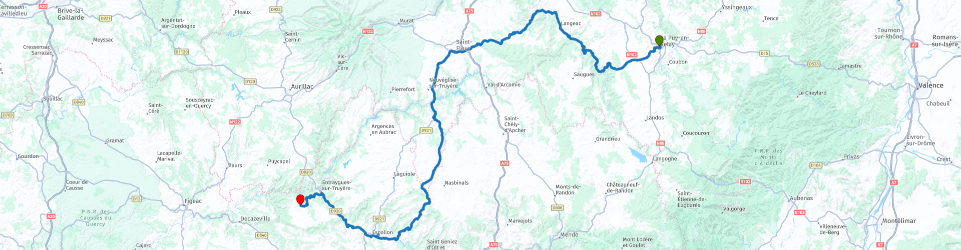
Questo itinerario segue l'itinerario tra le Puy-en-Velay e Senergues.
Oggi la Via Podensis è conosciuta soprattutto per la bellezza della natura che attraversi. Questo e le città e i villaggi medievali con bellissimi monumenti che visiti guadagnano una valutazione massima di cinque stelle.
 Condividi questo percorso


Animation

Verdetto


Durata
9h 24m

Modalità di viaggio
Auto o moto

Distanza
246.75 km

Paesi

 Revisione RouteXpert
 Nel Medioevo, molti pellegrini viaggiavano lungo alcune strade ben battute (ma non sempre facili o sicure) verso il luogo di pellegrinaggio di Santiago-de-Compostela, situato nell'angolo nord-occidentale della Spagna. Questa città si vantava di possedere il corpo di San Giacomo. Il percorso di pellegrinaggio attraverso la Spagna settentrionale formava un'unica linea. Prima di quella rotta, quattro strade principali attraversavano la Francia.
Una di queste rotte di rifornimento parte dal Massiccio Centrale in Francia e attraversa i Pirenei fino al confine spagnolo. Questa strada si chiama Via Podiensis ed è lunga 740 km. La Via Podiensis tocca diversi centri del sud della Francia di grande importanza religiosa, come Le Puy, Conques, Cahors, Moissac e Saint-Jean-Pied-de-Port.
Dal punto di vista paesaggistico si tratta di un percorso molto vario, che in parte si snoda attraverso valli gole (come la valle dell'Allier o del Célé). È un percorso tortuoso, quindi non coprirai molti chilometri al giorno. Se percorrete solo il tratto fino a Moissac, attraverserete le principali tappe religiose. L'ultimo tratto attraversa la pianura a sud della Garonna e l'inizio dei Pirenei. In termini di distanza, puoi dividere approssimativamente questo percorso in tre parti uguali.
Il primo tratto, questo itinerario, va da le Puy-en-Velay a Senergues.
La religione domina il centro di pellegrinaggio Le Puy-en-Velay. I "berretti a punta" di basalto, aghi di roccia che si innalzano dalla città, sono entrambi occupati da simboli religiosi: una bella cappella e una pomposa statua di Maria, realizzata con cannoni fusi. La torre della cattedrale è meno alta.
Le Puy è il punto di partenza della Via Podiensis. Poiché i pellegrini si affollavano qui prima di iniziare il lungo viaggio, la cattedrale doveva essere spaziosa. La grande navata è sormontata da cupole e un famoso dipinto, le 'Arts Libéraux', risplende nella Chapelle des Reliques.
Guidi fino a St.-Privat d'Allier, dove puoi fare rifornimento e da lì attraverso la valle delle gole dell'Allier. Dopo Aubazat, dove il caffè è pronto, si lascia l'Allier e si prosegue verso Chastel e St.-Flour.
Poi dirigiti a sud verso la città termale di Chaudes Aigues. Fin dall'antichità, Chaudes-Aigues era nota per la sua acqua calda, benefica per la salute e con l'acqua più calda d'Europa. Ci sono una trentina di sorgenti, la più famosa è la Source du Parc, una delle sorgenti più calde d'Europa (82 °C)!
Si salirà ora considerevolmente e sull'altopiano si raggiungerà Saint-Urcize per il pranzo. Il villaggio di montagna si trova a 1000 m di altitudine su una roccia basaltica che domina le valli dell'Hère e del Bes. Le vecchie case, i vicoli stretti, le piccole piazze ornate da fontane, i resti di fortificazioni e i ruderi dell'antica fortezza conferiscono alla città il suo carattere medievale e testimoniano le sue antiche origini. I tetti in ardesia grigia e scisto si fondono nella notevole chiesa romanica del XII secolo, il cui campanile crestato domina la città. La piccola campana del 1583 è considerata una delle più antiche di Francia e il deambulatorio garantisce che la città era una tappa del pellegrinaggio a Santiago di Compostela nel Medioevo.
Si prosegue attraverso l'altopiano attraverso il parco regionale dell'Aubrac e poi si scende attraverso la valle del Lot fino ad arrivare a Saint-Côme d'Olt, che si trova sul fiume Lot.
Questo villaggio è classificato come uno dei villaggi più belli di Francia. Danno un'impressione particolare la torre cittadina quasi rotonda e le mura fortificate che oggi sono diventate le facciate delle case. Il cuore del paese ha mantenuto il suo carattere medievale con le tre porte fortificate e le piccole vie. Nella città troverai monumenti storici, il luogo ideale per una piccola visita e una tazza di caffè.
Al prossimo posto: Espalion. I pellegrini di Santiago utilizzavano già nel Medioevo il passaggio del fiume Lot. Le vecchie concerie si specchiano nell'acqua del fiume. I pellegrini di solito si riposavano più a lungo a Espalion. Come te, si erano lasciati alle spalle le inaccessibili colline dell'Aubrac, ma le avevano attraversate a piedi. La città costituisce l'inizio del Rouergue. C'è un museo regionale in Place des Platanes. Un altro museo più grande si chiama Joseph Vaylet e mostra molte attrezzature subacquee. I residenti di Espalion hanno contribuito notevolmente allo sviluppo dell'attrezzatura subacquea.
Più avanti lungo il Lot si trova Estaing, un altro villaggio tra i più belli di Francia. Il ponte gotico degli inizi del XVI secolo e lo Chateau d'Estaing sono le prime cose che noti. Ma assicuratevi di passeggiare nel piccolo centro con strade strette, con belle facciate di case del XVI, XVII e XVIII secolo. Molto bello è anche l'Hôtel Crayon, oggi sede del municipio. L'Office du Tourisme si trova nel seminterrato e merita una visita anche solo per le sue volte. L'Église Saint-Fleuret contiene bellissime pale d'altare, tavole e statue. Le moderne vetrate colorate sono state realizzate dal famoso artista francese del vetro Claude Baillon.
Si continua a seguire il Lot fino a Entraygues-sur-Truyère. Un tempo i pellegrini si recavano qui in direzione della Vieillevie, voi invece utilizzerete ora il nuovo ponte sul Lot in direzione di Conques. Da qui una strada tortuosa ma piacevole conduce a Sérnergues. Il tuo punto finale di questo viaggio. Ci sono diverse possibilità di alloggio in questa città, come L'Ancien Poste e vari alloggi. Anche punti ristoro, ad esempio l'Auberge du Castel.
La chiesa di Sérnergues è il monumento storico più importante del centro del paese e presenta una facciata in pietra molto semplice, interrotta solo da un ingresso centrale in stile gotico e da una piccola finestra sopra la porta, a forma di quadrifoglio . Sul retro della chiesa c'è una torre quadrata in pietra con una galleria appena sotto il livello del tetto. Vedrai anche alcune belle case nel centro di Sénezergues, alcune interessanti statue in legno, un monumento ai caduti e splendide viste sul paesaggio del dipartimento del Cantal.
Nella valle sotto il centro di Sénezergues si può vedere il castello di Réghaud. Anche se il castello non è visitabile (oggi è un'imponente abitazione privata), è comunque possibile ammirarne l'architettura.


 Collegamenti
  Utilizzo
 Vuoi scaricare questo percorso?
Puoi scaricare il percorso gratuitamente senza un account MyRoute-app. Per farlo, apri il percorso e fai clic su 'Salva con nome'. Vuoi modificare questa rotta?
Nessun problema, inizia aprendo il percorso. Segui il tutorial e crea il tuo account MyRoute-app personale. Dopo la registrazione, la tua prova inizia automaticamente.  Disclaimer
L'utilizzo di questo percorso GPS è a tue spese e rischio. Il percorso è stato accuratamente composto e controllato da un RouteXpert accreditato dall'app MyRoute per l'utilizzo su TomTom, Garmin e navigazione dell'app MyRoute.
Ciononostante potrebbero essersi verificati cambiamenti a causa di mutate circostanze, deviazioni stradali o chiusure stagionali. Si consiglia pertanto di controllare ciascun percorso prima dell'uso.
Utilizzare preferibilmente la tracklog del percorso nel sistema di navigazione. Maggiori informazioni sul l'uso dell'app MyRoute può essere trovato sul sito Web in 'Community' o 'Academy'.

Auvergne Rhone Alpes
Informazioni su questa regione
L'Alvernia-Rodano-Alpi (in francese Auvergne Rhône-Alpes, in occitano Auvèrnhe Ròse Aups, in francoprovenzale Ôvèrgne-Rôno-Arpes) è una delle regioni della Francia.
Istituita nel 2016 in seguito alla riforma territoriale del 2014 aggregando le precedenti regioni Alvernia e Rodano-Alpi ed assumendo provvisoriamente il nome attuale, divenuto poi definitivo il 30 settembre 2016, è suddivisa in dodici dipartimenti più la metropoli del suo capoluogo, Lione, con altre città principali della regione che sono Saint-Étienne, Grenoble, Villeurbanne e Clermont-Ferrand.
Composta dai dipartimenti di Ain (01), Allier (03), Ardèche (07), Cantal (15), Drôme (26), Isère (38), Loira (42), Alta Loira (43), Puy-de-Dôme (63), Rodano (69), Savoia (73) e Alta Savoia (74), sono inclusi nella regione 242 cantoni e 4189 comuni ed è la seconda regione francese per importanza in termini di PIL.
Leggi di più su Wikipedia
Istituita nel 2016 in seguito alla riforma territoriale del 2014 aggregando le precedenti regioni Alvernia e Rodano-Alpi ed assumendo provvisoriamente il nome attuale, divenuto poi definitivo il 30 settembre 2016, è suddivisa in dodici dipartimenti più la metropoli del suo capoluogo, Lione, con altre città principali della regione che sono Saint-Étienne, Grenoble, Villeurbanne e Clermont-Ferrand.
Composta dai dipartimenti di Ain (01), Allier (03), Ardèche (07), Cantal (15), Drôme (26), Isère (38), Loira (42), Alta Loira (43), Puy-de-Dôme (63), Rodano (69), Savoia (73) e Alta Savoia (74), sono inclusi nella regione 242 cantoni e 4189 comuni ed è la seconda regione francese per importanza in termini di PIL.
Visualizza regione
 Statistiche
  125
125Quantità di recensioni RX (Auvergne Rhone Alpes)
 47716
47716Quantità di visitatori (Auvergne Rhone Alpes)
 6050
6050Quantità di download (Auvergne Rhone Alpes)
 Indirizza le collezioni in questa regione
 Le 24 vie alpine più belle
Le Alpi Le Alpi sono una catena montuosa in Europa, che si estende dalla costa mediterranea francese a sud-ovest alla pianura pannonica a est. L'area della catena montuosa è più di 200.000 km².
In altre parole Passi e Strade di Montagna!
Guidare attraverso le montagne è fantastico! Soprattutto sui passi di montagna con tornanti e strade strette e tortuose. Ad ogni curva un panorama diverso da cui godere. Ci sono molti bei passi di montagna nelle Alpi.
Una selezione che è stata inserita anche in questi percorsi:
Il Passo dello Stlevio:
Il Passo dello Stelvio, noto anche come Passo dello Stelvio, è conosciuto principalmente per la tappa del Giro d'Italia. A causa della lunghezza e del dislivello, questo passaggio è considerato uno dei test più duri del ciclismo. Il Passo dello Stelvio raggiunge un'altezza massima di 2758 metri ed è quindi uno dei più alti delle Alpi. Il passo collega i comuni di Bormio e Prato Allo Stelvio. In inverno il passo è chiuso per abbondanti nevicate.
Il Passo Resia:
Il Passo Resia, noto anche come Passo di Resia, collega lo stato austriaco del Tirolo con la provincia italiana dell'Alto Adige. Il passo raggiunge un'altezza massima di 1.504 metri ed è stato uno dei più importanti collegamenti nord-sud delle Alpi negli ultimi secoli. Il passo era utilizzato molto prima dell'epoca romana. Lungo la strada passerai diversi punti salienti e cimeli storici. Uno dei punti forti è il Lago di Resia. Questo lago è stato creato dopo la costruzione della diga e ha completamente sommerso il paese di Graun. L'unica cosa che lo ricorda è la torre dell'orologio in mezzo al lago.
Col du Galibier:
Il passo di montagna francese Col du Galibier collega le città di Saint-Michel-de-Maurienne e Briançon tramite il Col du Lautaret a sud e il Col du Télégraphe a nord. Il valico fa parte del Tour de France ed è molto temuto, in quanto raggiungibile solo attraverso gli altri due passi alpini. Il passo raggiunge un'altezza massima di 2646 metri. Da lì puoi fare una passeggiata fino al punto panoramico a 2704 metri. Qui puoi ammirare le vette del Grand Galibier, del Monte Bianco e della Meije.
La Strada alpina del Grossglockner:
Con un'altezza di 3798 metri il Grossglockner è la montagna più alta dell'Austria. Per godere appieno di questa imponente montagna, è possibile percorrere la Strada alpina del Grossglockner e il passo di accompagnamento. Il percorso parte da Bruck am Grossglockner e termina a Heiligenblut. Ovviamente puoi guidare in due direzioni. Il passo raggiunge un'altezza massima di 2504 metri ed è chiuso in inverno a causa di abbondanti nevicate. Lungo il percorso si superano diverse soste con attività ludiche, punti informativi, rifugi e punti panoramici. Si consiglia vivamente una visita al ghiacciaio Kaiser-Franz-Josefs-Höhe e Pasterzen.
Il Col d'Izoard:
Come il Col du Galibier, anche il Col d'Izoard fa parte di una tappa del Tour de France. Il valico collega Briançon con la valle del fiume Guil. Il passo si trova in parte nel Parco Naturale Regionale del Queyras e raggiunge un'altezza massima di 2360 metri. La particolarità del Col d'Izoard è il paesaggio arido e roccioso. A volte sembra di guidare un'auto sulla luna! Lungo il percorso è possibile sostare in più punti per godere del bellissimo panorama.
Il Passo del Bernina:
Il Bernina Express è uno dei treni ferroviari più famosi della Svizzera e delle Alpi. Il percorso è bellissimo e in parte inserito nella World Heritage List dell'UNESCO. Parallelo alla ferrovia si trova il passo del Bernina, che collega la Val Veltlin con la Val d'Egandin. Questa bellissima strada alpina ha una lunghezza totale di 56 chilometri e raggiunge un'altezza massima di 2328 metri. Lungo il percorso si può godere della vista sul ghiacciaio del Morteratsch.
Il Passo Sella:
Il Passo Sella, detto anche Passo di Sella, porta su uno dei gruppi montuosi più imponenti delle Dolomiti: il massiccio del Sella. Il passo collega la Valle di Fassa con la Val Gardena e raggiunge un'altezza massima di 2236 metri. A questa altezza si trova anche il confine delle province italiane del Trentino e di Bolzano. Lungo il percorso si può godere della vista di questo spettacolare mondo alpino. Ammirate, ad esempio, le tre cime del massiccio del Sasso Lungo, il massiccio del Sella o le vette della Marmolada. Si può percorrere anche il passo Sella in abbinamento al passo Gardena, passo Pordoi e passo Campolongo.
Il Passo del Grimsel:
Il passo del Grimsel collega il Goms nel Vallese con la Halistal nell'Oberland bernese. Il passo raggiunge un'altitudine massima di 2165 metri ed è chiuso in inverno per nevicate. Nel corso dei secoli, il valico ha svolto un ruolo importante nel commercio tra la Svizzera e l'Italia. Ora sono principalmente i serbatoi ad avere una funzione importante. Questi sono usati per generare elettricità. Il paesaggio che attraversi è aspro, roccioso e impressionante. In cima al passo si trovano un hotel e un ristorante con uno speciale parco delle marmotte. Anche il Dodensee (Totensee) si trova qui. Questo lago deve il suo nome ai tanti soldati morti al tempo di Napoleone.
Il Passo del San Gottardo:
Il Passo del San Gottardo, noto anche come Passo del San Gottardo e San Gottardo, collega le città svizzere di Airolo e Andermatt. Il passo di montagna e il relativo tunnel sono particolarmente conosciuti tra i vacanzieri che guidano dalla Svizzera all'Italia. Ma dove la maggioranza opta per il tunnel, è proprio il pass che completa davvero la vacanza. Il Passo del San Gottardo ha una lunghezza di circa 26 chilometri e raggiunge un'altezza massima di 2106 metri. Il percorso è bellissimo e ti porta lungo antichi borghi e bei panorami.
La Strada dell'Alta Silvretta e il Passo Silvretta:
La Valle di Paznaun in Tirolo e il Montafon nel Vorarlberg sono collegati dalla Strada alpina della Silvretta. Il percorso ha una lunghezza di 22,3 chilometri e conduce da Galtür a Partenen in 34 tornanti, attraverso il Bielerhöhe alto 2032 metri. In questo punto si trova anche il Silvrettasee, dove si può fare una bella passeggiata. Il passo è chiuso in inverno per nevicate.
Il Passo del Sempione:
Proprio come il Passo del San Gottardo, anche molti vacanzieri percorrono ogni anno il Passo del Sempione. Questo valico collega la Valle del Rodano nel Canton Vallese con la Valle d'Ossola in Piemonte. Il passo è aperto tutto l'anno e raggiunge un'altezza massima di 2005 metri. Lungo il percorso si passano una serie di edifici, tra cui il famoso Hospiz del Sempione del 1825. L'hospiz è gestito dai monaci di San Bernardo. Dal punto più alto del passo sono possibili tutti i tipi di percorsi escursionistici e incontrerete anche un albergo dove potrete pernottare.
Il Passo Gerlos:
Il Passo Gerlos collega la Valle del Salzach nel Salisburghese con la Valle Zillertal in Tirolo. Il passo fa parte della Gerlos Alpenstraße e attraversa il Parco Nazionale Alti Tauri. Lungo il percorso si possono godere splendidi panorami dei dintorni. Il passo ha una lunghezza di 12 chilometri e raggiunge un'altezza massima di 1531 metri. Un giro sul Gerlos Pass può essere idealmente combinato con una visita al Krimmler Wasserfälle.
Il Gran San Bernardo:
Il Colle del Gran San Bernardo, meglio conosciuto come Col du Grand Saint Bernard, collega la provincia italiana della Valle d'Aosta con il cantone svizzero del Vallese. Il passo è uno dei più alti della Svizzera e raggiunge un'altezza massima di 2469 metri. Come molti altri passi di montagna in questo elenco, anche il Gran San Bernardo è stato utilizzato per secoli come strada di collegamento. Il passo prende il nome dai cani di San Bernardo che aiutavano i viaggiatori bloccati insieme ai monaci. Il passo è chiuso in inverno.
La Strada alpina del Passo Rombo:
La Strada alpina del Passo Rombo collega le località di Sölden nella Ötztal e Merano in Alto Adige. I pedaggi devono essere pagati sulla tratta Hochgurgl - Moos. Attraverso una strada di montagna con circa 60 tornanti si guida attraverso un bellissimo mondo di montagne. Con l'esperienza del Passo Rombo puoi conoscere meglio la storia, la strada e l'ambiente attraverso varie stazioni. È inoltre possibile visitare il museo Top Mountain Crosspoint.
Col de l'Iseran:
Con un'altezza massima del passo di 2770 metri, il Col l'Iséran è uno dei passi di montagna più alti delle Alpi. Il passo collega Bourg-Saint-Maurice con Bonneval-sur-Arc. Attraverso una strada ricca di tornanti si passa, tra l'altro, Val-d'Isère e una valle laterale della Maurienne che si trova interamente nel Parco Nazionale della Vanoise. È possibile avvistare animali come marmotte e camosci e c'è anche un ristorante con una cappella in cima al passo.
Il Passo Gavia:
Il Passo Gavia (italiano Passo di Gavia) è un passo di montagna nelle Alpi italiane, nella regione Lombardia.
È una delle strade di passaggio più alte d'Europa. La strada conduce attraverso l'incontaminato Parco Nazionale dello Stelvio. La strada fu costruita durante la prima guerra mondiale per rifornire i soldati italiani che combatterono nella zona di confine italo-austriaca. L'altezza del passo è una delle più belle delle Alpi. Ecco il grande Lago Bianco con, a nord, il monte San Matteo (3684 metri). Il Lago Nero è leggermente più basso sul lato sud del passo. Qui il gruppo montuoso dell'Adamello determina il panorama. Ci sono molte passeggiate ben segnalate nella zona. Durante l'inverno il passo è chiuso a causa delle abbondanti nevicate. Il passo è spesso chiuso fino a maggio e giugno a causa della grande quantità di neve.
Il promotore ha selezionato i 24 percorsi alpini più belli che ha tracciato negli ultimi anni.
I percorsi attraversano:
Francia
Austria
Svizzera
Italia
Le strade più belle, i panorami più belli, i punti panoramici più belli. Le montagne più alte, le discese più veloci, tornante dopo tornante, e chi più ne ha più ne metta.
Se vai in vacanza in questa regione, approfittane, TUTTI i percorsi in questa raccolta sono stati controllati e resi uguali per TomTom, Garmin e MyRoute-app Navigation da un'app MyRoute RouteXpert.
Divertiti con questa collezione e mentre guidi uno di questi percorsi. Goditi tutta la bellezza che le Alpi e le Dolomiti hanno da offrire. Clicca su “Visualizza percorso” per leggere la recensione del percorso scelto.
Vorrei conoscere le vostre conclusioni sui percorsi.
Visualizza raccolta percorsi
25 magnifici sentieri in Francia
Questa raccolta di percorsi MRA contiene 25 bellissimi percorsi motociclistici in diverse parti della Francia, come le Ardenne, l'Alsazia, il Vercors, la Drôme, l'Ardèche, la Costa Azzurra, le Gorges du Verdon, l'Ariège, la Dordogna e la Bretagna.
I percorsi sono stati creati con cura da Bert Loorbach, che è lui stesso un appassionato motociclista. Ha vissuto in Francia per un anno e mezzo, durante il quale si è dedicato alla mappatura delle strade secondarie sconosciute e belle della Francia soprattutto per i motociclisti.
I percorsi sono raggruppati nella parte 1 di Motortourgids France della casa editrice Kosmos e ora sono disponibili anche in MyRouteApp.
Ho ripreso i percorsi in MRA e a volte li ho leggermente modificati per renderli ancora più interessanti per il motociclista.
Visualizza raccolta percorsi