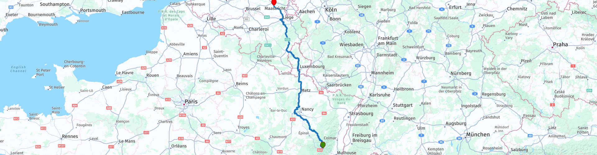
Col de Bussang to Hasselt while driving by the Moselle river and crossing the Ardennes

Esta ruta fue hecha por:
RouteXpert Guy Heyns - Sr RouteXpert
Última edición: 10-12-2024
 Resumen de ruta
 ¿Podría ser más rápido, quizás? ¿Podría ser más hermoso? Quizás sea así, pero no en un día si también quieres disfrutarlo un poco. ¡Y por suerte eso también es posible en esta ruta!
Esta ruta combina el regreso a Bélgica con un poco de conocimiento "hidrocultural".
Después de todo, la ruta transcurre en gran parte a través del conocido Mosela y el Canal de l'Est de regreso a través de Luxemburgo hasta Flandes.
El camino puede ser largo, pero es hermoso y hay algo que ver si estás dispuesto a prestarle atención.
Por eso casi queríamos darle a esta ruta una calificación de cinco estrellas, pero en el último minuto retiramos nuestra opinión. Por último, también haces gran parte de kilómetros de autopista 'aburridos', pero insuperables.
Sin embargo, esta ruta es definitivamente recomendable. Ella te llevará a donde debes estar desde los Vosgos a través de caminos divertidos e interesantes, ¡y tú también aprenderás algo!
 Compartir esta ruta


Animation

Veredicto


Duración
9h 41m

Modo de viaje
Coche o motocicleta

Distancia
511.24 km

Países


 Revisión de RouteXpert
 La cresta que quedó formó la frontera entre Francia y Alemania desde 1871 hasta 1918. 1918, lo leíste bien. El fin de la Primera Guerra Mundial. Después, los límites se cambiaron literalmente, pero ya puedes imaginar que el terreno de los Vosgos durante la Primera Guerra Mundial era un área particularmente turbulenta ...
Esta es la ruta de regreso que lo lleva desde Col de Bussang en los Vosgos hasta el flamenco Hasselt en Limburgo.
Sin embargo, esta ruta no puede llamarse tradicional, ya que también se puede aprender algo de ella. Al menos si tiene ojo y atención para ello.
Comenzamos en el Hotel du Col de Bussang después de despedirnos de nuestro anfitrión y nuestra señora.
Una primera gasolinera se encuentra 27 kilómetros después del inicio de la ruta. Sin embargo, recuerde que repostar en Luxemburgo es mucho más económico. Complete apropiadamente. Una pequeña recomendación también puede ser detenerse en un Intermarché u otra tienda departamental en el camino para abastecerse de un picnic. Los bares y cafés realmente buenos son más difíciles de encontrar en la primera parte. Hermosas áreas de picnic, por otro lado ...
Cosas de picnic amontonadas en las maletas conduces hacia la rp 15, donde encontrarás una hermosa área de picnic. Realmente no tendrá problemas para encontrar el lugar adecuado para un breve descanso. Si las condiciones meteorológicas no son las ideales para una escapada al aire libre, la panadería un poco más alejada puede ofrecer una alternativa agradable y, sobre todo, cubierta.
Pero antes de llegar a uno de estos puntos, primero pasa el Mosela y poco después el Canal de l'Est. Me gustaría decir algunas palabras sobre eso….
El Mosela se origina en los Vosgos. Es posible que haya conducido una de las rutas de la "Colección definitiva" que lo llevó al nacimiento de este río tan importante. Probablemente también recuerde lo pequeño que era en realidad este pozo.
El Canal de 'l'Est ha sido una parte inseparable del Mosela desde 1874 cuando comenzaron a construir el canal.
El canal tiene una longitud de no menos de 439 km y conecta el Saona con el Mosa y el Mosela. Por tanto, no es de extrañar que los capitanes le dieran al canal los nombres de "Canal de la Meuse" y "Canal des Vosges" para las partes norte y sur del canal, respectivamente.
Gran parte de esta ruta transcurre por el Mosela y el Canal de l'Est, pero a partir de la rp 16 se pone realmente interesante.
El Canal de l'Est no solo conecta el Mosa con el Saona y el Mosela, sino que también 'reemplaza' el Mosela en aquellas partes que son menos navegables o incluso no navegables en absoluto. Por lo tanto, el canal debe permanecer cerca del Mosela y así lo hace ... El canal a veces incluso cruza el Mosela, lo que realmente requiere pensar un poco. Después de todo, ¿cómo se deja que un canal, que es alimentado por el mismo Mosela, fluya completamente sobre el río sin que las aguas se toquen? No hace falta decir que las 152 cerraduras y sistemas de bombeo juegan un papel muy importante en esto. Pero piense ... estamos hablando de la construcción en 1874 ...
Cerca de la rp 16, cerca de Flavigny-sur-Moselle, puede visitar un acueducto de este tipo si lo desea. Todavía es un espectáculo un poco alucinatorio ... Por lo tanto, los acueductos no solo fueron construidos por los romanos ...
A partir de rp 16, es mejor tener lista la cámara o la GoPro montada. A partir de ahora experimentarás un digno ejemplo de hidroponía y eso durante unos 130 km. Literalmente, coqueteas a lo largo del Mosela, el Canal y muchas otras fuentes de agua. Aquellos que lo deseen también verán la prosperidad y otras consecuencias del Mosela y las obras hidráulicas asociadas.
A las 19 rp puede, si lo desea, tomar un descanso donde podrá disfrutar de un almuerzo más extenso a lo largo del Terrouin. Estás a solo 174 km de distancia, pero llevas casi 5 horas en la silla de montar, así que piénsalo.
'Le Terrouin' es un hablador interesante ... David, que se enfrenta a Goliat y también gana la batalla. El pequeño río de 30 kilómetros de largo fue el único responsable del hecho de que el Mosela, hace 300 000 años y que originalmente desembocaba en el Mosa, tuvo que desplazar su lecho hacia el este en dirección al Rin. Hoy todo el curso del Terrouin es una reserva natural protegida. En 'Le Pavillon Blue', nuestro lugar para almorzar, puede ver al Terrouin fluyendo hacia el Mosela después de haber ganado la batalla por el lecho del río con gran éxito.
Después del almuerzo coqueteamos un poco más con el río y el canal y finalmente, después de los primeros 200 kilómetros, comenzamos el primer viaje por carretera.
50 kilómetros más allá y después de pasar / cruzar las ciudades de Metz y Thionville, puede despedirse respetuosamente del poderoso Mosela. Lo pasas por última vez cerca de Thionville.
Se llega rápidamente al paso fronterizo entre Francia y Luxemburgo. Puede tomar un café en el Aire de Berchem. Pospondría el repostaje por un tiempo y, al igual que en la ruta de aproximación, desaconsejo dejar las motocicletas desatendidas.
Se recorre la ciudad de Luxemburgo y Ettelbruck, después de lo cual la ruta lo mima con un pasaje fuera de la autopista. Después de todo, nos dirigimos hacia el interior a través del Parc Naturel de la Haute-Sûre hasta Pommerloch, donde podemos abastecernos de la última gasolina valorada de Luxemburgo. Si lo desea, puede hacer una parada para tomar café en el elegante Pommerloch Hotel, justo antes de las estaciones de servicio. La elección es suya, pero tenga en cuenta que esta es la última parada antes de comenzar la última caminata por la carretera hasta el punto de despedida en Hasselt.
Afortunadamente, allí también encontrará las instalaciones sanitarias y de otro tipo necesarias para que pueda despedirse de sus compañeros de viaje, completamente iluminados, en uno de los restaurantes o no.
Debido a los muchos kilómetros aburridos de la carretera, la ruta, por supuesto, no puede obtener una calificación de cinco estrellas, pero para ser honesto, debido a la riqueza acuícola, realmente no hace mucha diferencia. Un pasaje por esta zona te enseñará mucho si quieres prestarle atención. Las carreteras están especialmente bien trazadas y, a veces, le sorprenderán gratamente, también en términos de vistas y placer de conducción. Por lo tanto, un merecido absoluto 4 estrellas para esta instructiva ruta de regreso.


 Enlaces
  Uso
Uso ¿Quiere descargar esta ruta?
Puede descargar la ruta gratis sin la cuenta de MyRoute-app. Para hacerlo, abra la ruta y haga clic en 'guardar como'. ¿Quiere editar esta ruta?
No hay problema, comience abriendo la ruta. Siga el tutorial y cree su cuenta personal de MyRoute-app. Después de registrarse, su prueba comienza automáticamente.  Descargo de responsabilidad
El uso de esta ruta GPS es por su cuenta y riesgo. La ruta ha sido cuidadosamente compuesta y verificada por un RouteXpert acreditado por MyRoute-app para su uso en TomTom, Garmin y MyRoute-app Navigation.
No obstante, es posible que se hayan producido cambios debido a circunstancias cambiantes, desvíos de carreteras o cierres estacionales. Por lo tanto, recomendamos comprobar cada ruta antes de utilizarla.
Utilice preferentemente el track de ruta en su sistema de navegación. Más información sobre el el uso de la aplicación MyRoute se puede encontrar en el sitio web en 'Comunidad' o 'Academia'.