Zeilberg Bollendorf

Deze route is gemaakt door:
RouteXpert Hans van de Ven (Mr.MRA)
Laatst gewijzigd: 03-03-2019
 Route Samenvatting
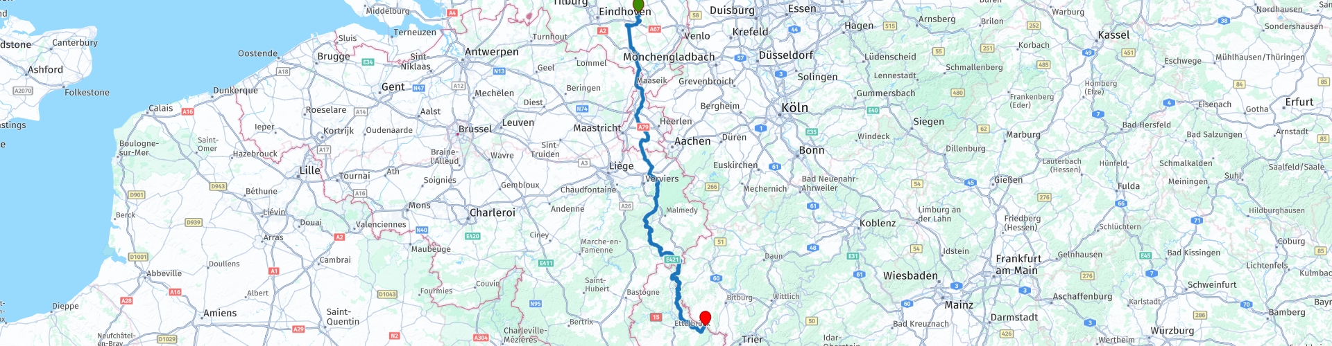
 Startpunt: Café Zaal 't-Vertierke in Deurne (Zeilberg).
Eindpunt: Hotel Café Hauer in Bollendorf.
 Deel deze route


Animation

Beoordeling


Duur
6h 3m

Transportmodus
Auto of motor

Afstand
295.52 km

Landen


 RouteXpert Review
 Wat vonden wij destijds van het hotel: https://www.mtczeilberg.nl/verslagen_details.phtml?id=3
Nadat je uit Zeilberg bent vertrokken, rijd je binnendoor naar Klimmen, waar de 1e (koffie) stop is gepland bij IJssalon Pleinzicht. Voor de IJssalon ligt een grote parkeerplaats waar je de motor mooi in het zicht kunt parkeren.
Na de koffie rijden we verder en stoppen vervolgens nog bij de Amerikaanse militaire begraafplaats Henri-Chapelle en Lac de la Gileppe om wat foto's te maken.
---
De ruim 20 hectare van de Amerikaanse militaire begraafplaats Henri-Chapelle herbergen de stoffelijke overschotten van 7.992 Amerikaanse soldaten. De meeste van deze mannen verloren hun leven tijdens de opmars van de Amerikaanse strijdkrachten in Duitsland. De 1e Amerikaanse Infanteriedivisie bevrijdde deze locatie op 11 september 1944. Een voorlopige oorlogsbegraafplaats werd ingericht op 28 september 1944.
Hun grafstenen staan opgesteld in wijdse bogen op een uitgestrekt naar beneden glooiend grasveld. Een weg doorsnijdt de begraafplaats. Ten westen daarvan biedt een uitkijkpunt een prachtig vergezicht over het vredige Belgische platteland dat ooit een slagveld was. In oostelijke richting is er een zuilenrij die samen met de kapel en de bezoekersruimte de memorial vormt. De kapel is simpel, maar rijk versierd. De bezoekersruimte bevat twee kaarten die een inzicht geven in de militaire operaties van het Amerikaanse leger, gegraveerd in zwart graniet, met inscripties die verwijzen naar de overwinningen van de Amerikaanse strijdkrachten. Op de rechthoekige pijlers van de zuilenrij zijn de namen van 450 vermiste soldaten gegraveerd. Achter de namen van de vermisten die alsnog zijn gevonden en geidentficeerd is een rozet aangebracht.
De begraafplaats herbergt de Amerikaanse doden van twee belangrijke militaire campagnes: de veldtocht van het 1e Amerikaanse Leger door Noord-Frankrijk, België, Nederland en Luxemburg richting Duitsland (september 1944) en de Battle of the Bulge, het Duitse tegenoffensief in de Ardennen (december 1944 - januari 1945).
Vanaf de tijdelijke begraafplaats Henri-Chapelle werden de eerste repatriëring georganiseerd van gevallen Amerikaanse soldaten naar de Verenigde Staten voor herbegrafenis in eigen land. Het repatriëringsprogramma begon op 27 juli 1947 met een speciale plechtigheid in Henri-Chapelle. Het eerste schip met stoffelijke resten vertrok begin oktober uit Antwerpen na een indrukwekkende ceremonie die werd bijgewoond door 30.000 Belgische burgers.
---
De Gileppestuwdam (Frans: barrage de la Gileppe) is een stuwdam in de Belgische provincie Luik. De toevoer van water wordt verzekerd door de in de Hoge Venen ontspringende Gileppe. De oorspronkelijke muur was de oudste betonnen stuwdammuur van Europa. Het complex werd op 28 juli 1878 door koning Leopold II officieel geopend. De wateropnamecapaciteit van het stuwmeer bedroeg toen 13 miljoen m³, met een oppervlakte van 86 ha. Het oorspronkelijk doel van de stuwdam was het voorzien in bruikbaar water voor de textielindustrie in de omgeving van Verviers.
In de periode 1968-1971 werd de dam met meer dan 10 m verhoogd. Sindsdien bedraagt de capaciteit van het meer 26,5 miljoen m³ bij een oppervlakte van 130 ha. Samen met de Vesderstuwdam te Eupen voorziet het meer heden ten dage in drinkwater.
Het belangrijkste kenmerk van de dam is een 13,5 meter hoge en 300 ton zware leeuw uit zandsteen. De leeuw staat boven op de dammuur en werd zo neergezet zodat hij trots uitkijkt in de richting van de slechts 5 kilometer verwijderde grens met het toenmalige Pruisen.
---
Na het maken van de foto's wordt het tijd om te lunchen, dit doen we bij de Watervallen van Coo, waar je ook weer je motor in het zicht kunt parkeren. Er is keuze genoeg, dus voor elk wat wils.
Na de lunch slingeren we veelal over mooie motorwegen door richting Ouren waar we bij Hotel Rittersprong stoppen voor koffie met wat lekkers. Ook hier staan de motoren weer mooi in het zicht. We stoppen onderweg nog een keer in Hosingen bij Dosberbreck Sam's Lounge om de benen te strekken en voor te tanken. Na de koffie weer door, de brug (routepunt 61) is in juli (we hebben dus geluk) door hevige regenval helemaal weggeslagen. Net voordag we bij het eindpunt van deze route aankomen, tanken we eerst even nu we nog in Luxemburg zijn bij de Q8, daarna steken we de Sauer over en gaan rechts af. Als je bij foto 3 kijkt, zie je dat het water in de Sauer al erg hoog staat.
We zijn bij Hotel Hauer, waar we verblijven voor het Voorjaarsweekend.
Zie de video om een indruk te krijgen van de omgeving, de beelden zijn af en toe wat onduidelijk, maar dat komt door de vele regen die we onderweg gehad hebben: https://www.youtube.com/watch?v=fWsDKEeDmzQ


 Gebruik
 Deze route downloaden?
Je kan de route gratis, zonder MyRoute-app account downloaden. Om dit te doen, open de route en klik op 'opslaan als'. Deze route wijzigen?
Geen probleem, open eerst de route. Volg de tutorial en maak je eigen MyRoute-app account aan. Na registratie, start je trial automatisch.  Disclaimer
Gebruik van deze gps-route is voor eigen rekening en risico. De route is met zorg samengesteld en door een MyRoute-app geaccrediteerde RouteXpert gecontroleerd voor gebruik op zowel TomTom, Garmin als MyRoute-app Navigation.
Door gewijzigde omstandigheden, wegomleidingen of seizoensafsluitingen kunnen er toch veranderingen zijn ontstaan. Daarom adviseren wij iedere route voor gebruik te controleren.
Gebruik bij voorkeur de routetrack in je navigatiesysteem. Meer uitleg over het gebruik van MyRoute-app kun je vinden op de website bij ‘Community’ of ‘Webinars’.

Henegouwen
Over deze Regio
Wallonië (Frans: Wallonie; Duits: Wallonie(n); Waals: Walon(r)eye) is een van de drie gewesten in België.
Wallonië is het zuidelijke, in hoofdzaak Franstalige deel van België. De inwoners worden Walen genoemd. Wallonië beslaat met 16.844 km² in oppervlakte ruim de helft van het land. Het is met 3,6 miljoen inwoners – een derde van de Belgische bevolking – aanzienlijk dunner bevolkt dan Vlaanderen, het noordelijke deel van België, waar vooral Nederlands wordt gesproken.
Bestuurlijk komt Wallonië overeen met het Waals Gewest, met inbegrip van de gemeenten van de Duitstalige Gemeenschap. Het gewest regelt de gebiedsgebonden zaken (bijvoorbeeld infrastructuur) in het gebied. Daarnaast bestaat de Franse Gemeenschap, die beleid voert op onderwerpen als onderwijs, welzijn en media voor de Franstalige inwoners van zowel Wallonië als het Brussels Hoofdstedelijk Gewest.
Behalve aan Vlaanderen grenst het gewest aan Frankrijk (zuidgrens), het groothertogdom Luxemburg, Duitsland en Nederland. De hoofdstad van het Waals Gewest is Namen, dat circa 110.000 inwoners telt. Een groot deel van Wallonië ligt relatief hoog boven de zeespiegel, het wordt gedomineerd door de Ardennen. Wallonië behoort tot de eerste gebieden van het Europese vasteland waar de Industriële revolutie doordrong, dit vooral in de provinicies Henegouwen en Luik.
Lees meer op Wikipedia
Wallonië is het zuidelijke, in hoofdzaak Franstalige deel van België. De inwoners worden Walen genoemd. Wallonië beslaat met 16.844 km² in oppervlakte ruim de helft van het land. Het is met 3,6 miljoen inwoners – een derde van de Belgische bevolking – aanzienlijk dunner bevolkt dan Vlaanderen, het noordelijke deel van België, waar vooral Nederlands wordt gesproken.
Bestuurlijk komt Wallonië overeen met het Waals Gewest, met inbegrip van de gemeenten van de Duitstalige Gemeenschap. Het gewest regelt de gebiedsgebonden zaken (bijvoorbeeld infrastructuur) in het gebied. Daarnaast bestaat de Franse Gemeenschap, die beleid voert op onderwerpen als onderwijs, welzijn en media voor de Franstalige inwoners van zowel Wallonië als het Brussels Hoofdstedelijk Gewest.
Behalve aan Vlaanderen grenst het gewest aan Frankrijk (zuidgrens), het groothertogdom Luxemburg, Duitsland en Nederland. De hoofdstad van het Waals Gewest is Namen, dat circa 110.000 inwoners telt. Een groot deel van Wallonië ligt relatief hoog boven de zeespiegel, het wordt gedomineerd door de Ardennen. Wallonië behoort tot de eerste gebieden van het Europese vasteland waar de Industriële revolutie doordrong, dit vooral in de provinicies Henegouwen en Luik.
Bekijk regio
 Statistieken
  99
99Aantal RX reviews (Henegouwen)
 27246
27246Aantal bezoekers (Henegouwen)
 22519
22519Aantal downloads (Henegouwen)
 Route Collecties in deze regio
 De 10 mooiste auto en motorroutes in Limburg
Limburg, wie aan Limburg denkt, denkt aan vlaai, kolenmijnen, mergel en het heuvelland. De kolenmijnen zijn alweer bijna 40 jaar gesloten, de laatste vracht steenkolen werd op 31 december uit de Oranje-Nassau steenkolenmijn te Heerlen naar boven gehaald en werd, zoals ze zeggen, Zuid-Limburg omgetoverd van Zwart naar Groen en is er helaas nog weinig te zien van deze periode.
Maar niet alleen vlaai, mergel en kolen in Limburg, maar ook een hele mooie provincie om met de auto of motor doorheen te toeren en te genieten van al het moois wat de provincie Limburg te bieden heeft. Hiervoor heeft de MyRoute-app RouteXpert een Top 10 van Auto- en Motorroutes voor je samengesteld.
Alle routes in deze collectie zijn gecontroleerd en gelijk gemaakt voor TomTom, Garmin en MyRoute-app Navigation door een MyRoute-app RouteXpert.
Mocht je denken, ik heb een hele mooie route die zeker niet mag ontbreken aan deze collectie, stuur deze dan naar:
email: routexpert@myrouteapp.com
Onderwerp: Nieuwe Route voor de Top 10 collectie Provincie Limburg samengesteld door Hans van de Ven.
De route zal dan gereviewd worden en vervolgens toegevoegd worden aan de Top 10.
Om de Top 10 ook de Top 10 te laten, zal er 1 route uit de Top 10 moeten verdwijnen, dit mag jij aangeven bij het aanleveren van de nieuwe route.
Heel veel plezier met deze collectie en tijdens het rijden van een van deze routes. Geniet van al het moois wat Nederland en in het bijzonder de provincie Limburg te bieden heeft. Klik op “Route bekijken” om de review van de gekozen route te lezen.
Graag hoor ik jullie bevindingen over de route(s).
Bekijk Route Collectie
Top 5 Auto en Motorroutes in de Eifel
De Eifel is het oostelijke deel van het middelhoog plateau Eifel-Ardennen. Het ligt ten noorden van de Moezel en ten westen van de Rijn. Het grootste deel ligt in Duitsland, een klein deel ligt in België, in de Oostkantons. Het Duitse deel van Eifel ligt in de deelstaten Noordrijn-Westfalen en Rijnland-Palts. Het hoogste punt is de Hohe Acht met 747 meter.
In de Eifel zijn verscheidene ketens te onderscheiden:
Het noordelijkste gedeelte noemt men de Nordeifel, dat in België aansluit op de Hoge Venen;
Ten oosten daarvan vindt men het Ahrgebirge, dit gedeelte bevindt zich benoorden de Ahr in het district Ahrweiler;
Bezuiden de Ahr bevindt zich de Hohe Eifel (of Hocheifel), waarvan de Hohe Acht (747 m) het hoogste punt is, en tevens het hoogste punt van het hele Eifelgebied;
In het westen, tegen de Belgische grens, zijn de heuvels bekend als Schneifel, een onderdeel van het bredere gebied van de Sneeuweifel met toppen die reiken tot 698 meter;
Zuidelijk en oostelijk van de Hohe Eifel ligt de Vulkaan-Eifel, een vulkanisch gebied met veel kratermeren (Maare).
Het zuidelijke gedeelte van de Eifel is minder hoog. Het gebied wordt doorsneden door in zuidelijke richting uitlopende beken en riviertjes. Deze stromen monden in de Moezel. De grootste van deze rivieren is de Kyll; de heuvels rond deze rivier zijn bekend als het Kyllwald;
In het zuiden eindigt de Eifel in de Voreifel.
In het noorden van de Eifel bevinden zich enige grote stuwmeren. Het grootste daarvan is het stuwmeer in de Roer dat is ontstaan door de bouw van de Roerdaldam.
In de Eifel ligt ook de Nürburgring, een bekend autocircuit voor onder andere Formule 1-races. Sinds 2004 is een deel van het noorden van de Eifel het Nationaal Park Eifel geworden. Dit Nationale Park valt in zijn geheel binnen het Duits-Belgische natuurpark Hoge Venen-Eifel. Een ander deel van de Eifel valt binnen het natuurpark Zuid-Eifel.
Bekend bij heel Auto- en Motorrijdend Nederland & Belgie, dus reden genoeg voor de MyRoute-app RouteXpert een Top 5 van Auto- en Motorroutes voor je samen te stellen.
Alle routes in deze collectie zijn gecontroleerd en gelijk gemaakt voor TomTom, Garmin en MyRoute-app Navigation door een MyRoute-app RouteXpert.
Mocht je denken, ik heb een hele mooie route die zeker niet mag ontbreken aan deze collectie, stuur deze dan naar:
email: routexpert@myrouteapp.com
Onderwerp: Nieuwe Route voor de Top 5 collectie Eifel samengesteld door Hans van de Ven.
De route zal dan gereviewd worden en vervolgens toegevoegd worden aan de Top 5. Om de Top 5 ook de Top 5 te laten, zal er 1 route uit de Top 5 moeten verdwijnen, dit mag jij aangeven bij het aanleveren van de nieuwe route.
Heel veel plezier met deze collectie en tijdens het rijden van een van deze routes. Geniet van al het moois wat de Eifel te bieden heeft. Klik op “Route bekijken” om de review van de gekozen route te lezen.
Graag hoor ik jullie bevindingen over de route(s).
Bekijk Route Collectie