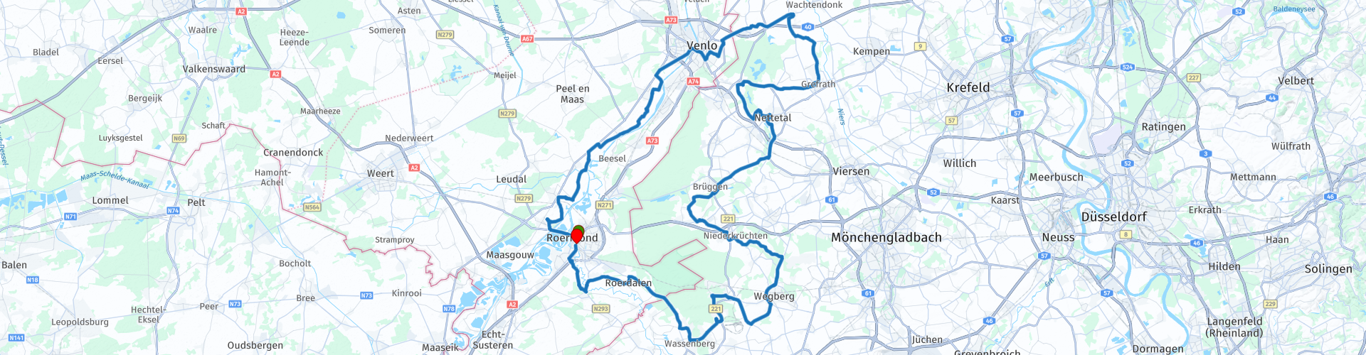
NL D Roermond Venlo Nettetal Roermond 148km

Cet itinéraire a été créé par:
RouteXpert Johan Baars (RouteXpert)
Dernière modification: 26-11-2019
 Résumé de l'itinéraire
 De Roermond, parcourez environ 148 km
 Partager cet itinéraire


Animation

Verdict


Durée
3h 55m

Mode de déplacement
Voiture ou moto

Distance
147.95 km

Pays


 RouteXpert Review
 Le parcours que j’ai donné le nom des villes: Roermond Venlo Nettetal Roermond a une longueur de 148 km et nécessite environ 4 heures de temps de trajet.
Dans le Promoteur, cet itinéraire était présenté avec le nom Maas Schwalm Nette, ces noms sont liés aux rivières, aux ruisseaux qui suivent l'itinéraire.
Du côté néerlandais, la Meuse entre Roermond et Venlo est le principe directeur. Juste après Neer, vous avez une vue magnifique depuis la haute rive de la Meuse.
Du côté allemand, vous rencontrerez le Nette. Cela disparaît à Leuth dans le Wittsee. Mais plus tard, le Nette apparaît à nouveau. Le Schwalm est visible à Amern. Il passe par la ville fortifiée de Brüggen vers Neer aan de Maas. Wassenberg est l'endroit idéal pour une introduction à la Ruhr. Vous le retrouverez à Sint Odiliënberg aux Pays-Bas sous le nom de Roer. Outre les rivières, cet itinéraire propose également des lieux à visiter, des moulins à eau, des églises et des châteaux.
Le départ et l’arrivée se font à l’hôtel Roermond, Stationsplein 9 à Roermond.
Source: Promoteur 11/2018 Etant donné que je n'ai pas encore conduit la route moi-même, je lui donne 3 étoiles.


 Utilisation
 Vous voulez télécharger cette route?
Vous pouvez télécharger l'itinéraire gratuitement sans compte MyRoute-app. Pour ce faire, ouvrez l'itinéraire et cliquez sur 'enregistrer sous'. Vous voulez éditer cette route?
Pas de problème, commencez par ouvrir la route. Suivez le tutoriel et créez votre compte personnel MyRoute-app. Après l'enregistrement, votre essai démarre automatiquement.  Avertissement
L'utilisation de cet itinéraire GPS est à vos propres frais et risques. L'itinéraire a été soigneusement composé et vérifié par un RouteXpert accrédité par MyRoute-app pour une utilisation sur TomTom, Garmin et MyRoute-app Navigation.
Des modifications peuvent néanmoins s'être produites en raison de circonstances modifiées, de déviations de routes ou de fermetures saisonnières. Nous vous recommandons donc de vérifier chaque itinéraire avant de l'utiliser.
Utilisez de préférence le tracé de l'itinéraire dans votre système de navigation. Plus d'informations sur le l'utilisation de MyRoute-app peut être trouvée sur le site Web sous 'Communauté' ou 'Académie'