TTT 1994 03 Van Deventer naar Zwartemeer

Cet itinéraire a été créé par:
RouteXpert Hans van de Ven (Mr.MRA)
Dernière modification: 23-05-2020
 Résumé de l'itinéraire
 Les 173 ANWB Promoter TankTasTochten (TTT) ont été scannés par Henry ten Dam et signés par Leon Stolk dans Mapsource, puis placés en tant que piste dans un fichier .gpx. Celles-ci ont été mises à disposition avec l'approbation de ANWB Promotor via le site Web de MrGPS afin que tout le monde puisse en profiter. Le 1er TTT date de 1992. Le parcours peut donc être légèrement différent de celui d'origine.
J'ai vérifié tous les points de l'itinéraire et les ai placés soigneusement sur la route. De plus, si nécessaire, j'ai placé le point de départ et le point d'arrivée de la route un peu plus éloignés pour éviter de naviguer directement vers le point d'arrivée et j'ai ajouté les fichiers POI des points de départ et d'arrivée exactement comme un point d'arrêt possible.
Enfin, j'ai créé l'itinéraire pour les utilisateurs de navigation TomTom, Garmin et MyRoute-app.
Merci à Henry, Leon, MrGPS et Promoter.
 Partager cet itinéraire


Animation

Verdict


Durée
4h 8m

Mode de déplacement
Voiture ou moto

Distance
151.49 km

Pays


 RouteXpert Review
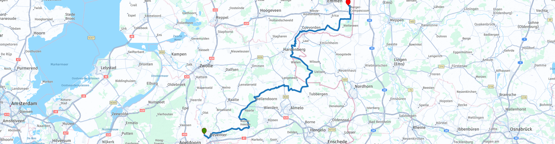
 Nous continuons donc là où le TTT précédent s'était arrêté, à Terwolde. Cet itinéraire concerne principalement de belles routes. Un peu plus loin sur l'IJssel pour le traverser puis traverser Deventer pour Lettele. Le long du parc national de Sallandse Heuvelrug, prenez la direction de Geesteren, traversez un peu l'Allemagne et suivez la direction de Coevorden pour atteindre le point d'arrivée à Zwartemeer.
Comme il est possible qu’il n’y ait pas d’option déjeuner à mi-parcours, il est conseillé d’apporter un panier-repas et un verre pour pouvoir pique-niquer en cours de route.
Parce que je n'ai pas (encore) conduit cette route moi-même, cette route a 3 étoiles.
Détails de la route:
L'itinéraire est créé pour les utilisateurs de navigation TomTom, Garmin et MyRoute-app. Cela a réussi partout sauf dans Animaux entre les points 25 et 26 de la route (violet), TomTom et Garmin ne sont pas d’accord. Pas de gros problème, si vous conduisez seul, il vous suffit de suivre les instructions de votre GPS, vous conduisez en groupe, puis vous suivez le coureur avant. À partir du point 26 de la route, les deux se réuniront à nouveau et votre GPS suivra correctement la route.


 Utilisation
 Vous voulez télécharger cette route?
Vous pouvez télécharger l'itinéraire gratuitement sans compte MyRoute-app. Pour ce faire, ouvrez l'itinéraire et cliquez sur 'enregistrer sous'. Vous voulez éditer cette route?
Pas de problème, commencez par ouvrir la route. Suivez le tutoriel et créez votre compte personnel MyRoute-app. Après l'enregistrement, votre essai démarre automatiquement.  Avertissement
L'utilisation de cet itinéraire GPS est à vos propres frais et risques. L'itinéraire a été soigneusement composé et vérifié par un RouteXpert accrédité par MyRoute-app pour une utilisation sur TomTom, Garmin et MyRoute-app Navigation.
Des modifications peuvent néanmoins s'être produites en raison de circonstances modifiées, de déviations de routes ou de fermetures saisonnières. Nous vous recommandons donc de vérifier chaque itinéraire avant de l'utiliser.
Utilisez de préférence le tracé de l'itinéraire dans votre système de navigation. Plus d'informations sur le l'utilisation de MyRoute-app peut être trouvée sur le site Web sous 'Communauté' ou 'Académie'