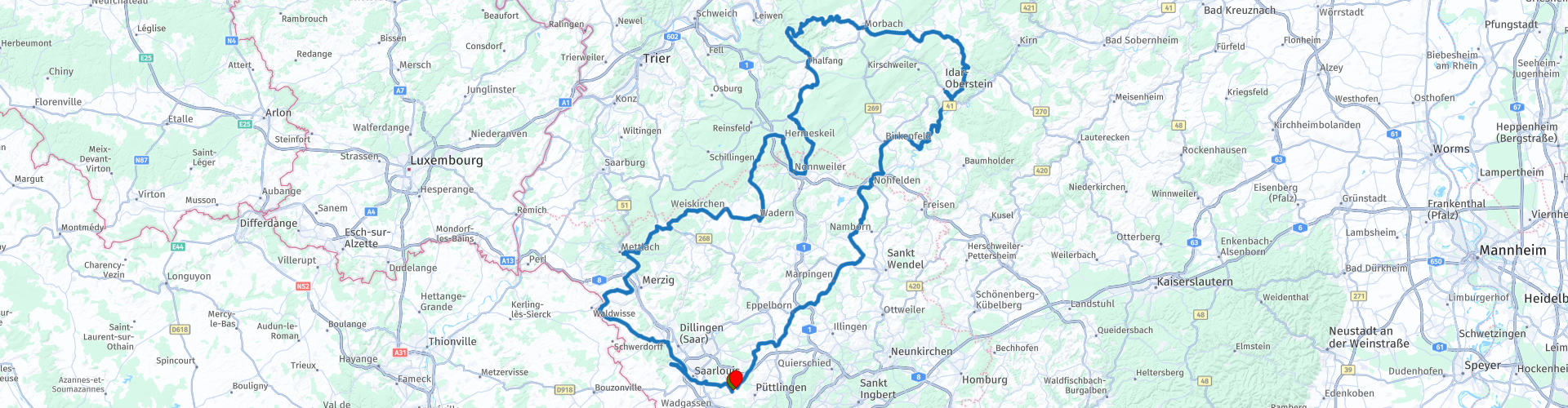
Roundtrip Saarlouis Idar Oberstein

Deze route is gemaakt door:
RouteXpert Evert Kuiken
Laatst gewijzigd: 14-04-2021
 Route Samenvatting
  Deel deze route


Animation

Beoordeling


Duur
5h 12m

Transportmodus
Auto of motor

Afstand
273.39 km

Landen

 RouteXpert Review
 Wat is er allemaal te zien langs deze route:
RP 3 Saarlouis. Deze vesteingstad werd in 1680 gesticht door Koning Lodewijk XIV. Er zijn nog veel restanten van de vesting te zien.
RP 5 Ruine van kasteel Siersburg
RP 8 Keuchingen heeft veel om te zien. Een keramiek museum, een kasteel en toren en een leuk centrum. Alles aan de rand van de rivier de Saar.
RP 9 Uitzichtspunt
RP11 Ruine van kasteel Grimburg
RP12 Museum over kasteel Grimburg en heksen.
RP13 Museum met stoomlocomotieven
RP14 Museum over de brandweer
RP16 Leuk om te bezoeken is de Keltische muur met een nagebouwd Keltisch dorp ernaast. Er vlak bij is ook een uitzichtspunt over het stuwmeer van Nonnweiler.
RP17 Vlak voorbij de Keltische muur kun je een smidse bezoeken: Züscher Hammer. Aangedreven door waterkracht.
RP18 Een vliegtuigmuseum met veel straalvliegtuigen, o.a. een Concorde en een De Havilland Comet.
RP20 In Morbach kun je stoppen voor koffie of lunch. Daar kun je ook twee musea bezoeken: een museum over telefoons en een museum over houtbewerking.
RP21 Herrstein is een klein oud dorpje met een kasteel, klokketoren en veel vakwerkhuizen. De moeite waard om even doorheen te lopen.
RP22 Het vliegveld van Idar-Oberstein. Klein maar leuk en met zweefvliegtuigen. En je kunt er lunchen. Bij RP23 is een ander lunchrestaurant.
RP24 Idar-Oberstein met het edelsteen museum. Dit is het edelstenen centrum van Duitsland. Veel winkels en restaurants. Genoeg te beleven voor een stop.
RP25 Kasteelruine Frauenberg.
RP29 Een vliegveld met zweefvliegtuigen. Of bezoek het plaatsje Marpingen en drink daar wat.
RP30, 33, 34 In dit gebied zijn veel religieuze grotten, zoals de Lourdesgrotte in Dirmingen (RP30), de Espengrotte (RP33) in Giesenbach en de Mariengrotte (RP34) in Schwarzenholz.
Deze route krijgt van mij 4 sterren. Er is veel te doen, de omgeving is mooi en de wegen zijn goed.


 Links
Links  Gebruik
 Deze route downloaden?
Je kan de route gratis, zonder MyRoute-app account downloaden. Om dit te doen, open de route en klik op 'opslaan als'. Deze route wijzigen?
Geen probleem, open eerst de route. Volg de tutorial en maak je eigen MyRoute-app account aan. Na registratie, start je trial automatisch.  Disclaimer
Gebruik van deze gps-route is voor eigen rekening en risico. De route is met zorg samengesteld en door een MyRoute-app geaccrediteerde RouteXpert gecontroleerd voor gebruik op zowel TomTom, Garmin als MyRoute-app Navigation.
Door gewijzigde omstandigheden, wegomleidingen of seizoensafsluitingen kunnen er toch veranderingen zijn ontstaan. Daarom adviseren wij iedere route voor gebruik te controleren.
Gebruik bij voorkeur de routetrack in je navigatiesysteem. Meer uitleg over het gebruik van MyRoute-app kun je vinden op de website bij ‘Community’ of ‘Webinars’.

Hunsrück
Over deze Regio
De Hunsrück is een middelgebergte dat deel uitmaakt van het Rijnlands leisteenplateau in de Duitse deelstaat Rijnland-Palts en een klein deel in Saarland.
Bepaalde delen van het gebergte hebben eigen namen zoals het Idarwald, het Soonwald, het Binger Wald, het Schwarzwälder Hochwald en het Osburger Hochwald. De inwoners van de streek noemen de Hunsrück "Hundsbuckel". Een deel van het gebergte wordt beschermd en maakt deel uit van het Nationaal Park Hunsrück-Hochwald.
Lees meer op Wikipedia
Bepaalde delen van het gebergte hebben eigen namen zoals het Idarwald, het Soonwald, het Binger Wald, het Schwarzwälder Hochwald en het Osburger Hochwald. De inwoners van de streek noemen de Hunsrück "Hundsbuckel". Een deel van het gebergte wordt beschermd en maakt deel uit van het Nationaal Park Hunsrück-Hochwald.
Bekijk regio
 Statistieken
  65
65Aantal RX reviews (Hunsrück)
 17092
17092Aantal bezoekers (Hunsrück)
 10445
10445Aantal downloads (Hunsrück)
 Route Collecties in deze regio
 11 daagse trip vanuit Nederland
8 landen in 11 dagen; Nederland, Duitsland, Oostenrijk, Italië, Zwitserland, Frankrijk, Luxemburg en België. Deze routecollecties bestaat uit 10 routes die ik met vrienden in de zomer van 2019 heb gereden.
De start is in Geldermalsen Nederland, de eerste 7 dagen rij je door Nederland, Duitsland, Oostenrijk, Italië, Zwitserland, Frankrijk en een stukje Luxemburg met overnachtingen in hotels.
De laatste drie dagen verblijf je in Barweiler (D) in de Eifel en rij je twee mooie rondritten door de Eifel, Luxemburg en delen van de Belgische Ardennen.
In de routes zit geen snelweg, alleen mooie provinciale- en landwegen, veel mooie passen met prachtige panorama's.
Informeer je goed voordat je vertrekt of de passen open zijn.
Dit zijn routes voor ervaren rijders.
Bekijk Route Collectie
Routecollectie hairpins in de Eifel
Deze collectie is samengesteld uit de meest mooie en bochtige wegen in de Eifel. Vergeet Bundesstraßen, vergeet de weg langs de Moezel, als je deze wegen gereden hebt, dan kun je past echt zeggen dat je in de Eifel bent geweest.
Maar liefst 6 routes en 1.800 kilometers liggen op je te wachten!
Maar liefst 6 routes en 1.800 kilometers liggen op je te wachten!
Bekijk Route Collectie