Canary Islands round trip Tenerife Costa Adeje

Esta ruta fue hecha por:
RouteXpert Sandro Linden
Última edición: 28-05-2022
 Resumen de ruta
  Compartir esta ruta


Animation

Veredicto


Duración
0h 0m

Modo de viaje
Coche o motocicleta

Distancia
0.00 km

Países

 Revisión de RouteXpert
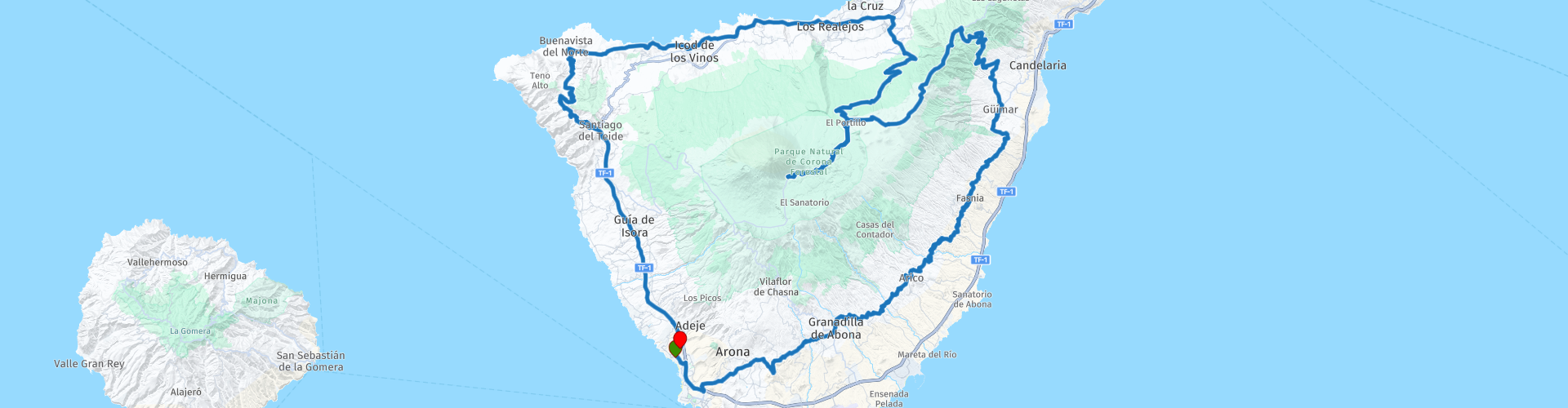
 Comenzamos la ruta en el hotel en Costa Adeje. Desde aquí seguimos el sinuoso camino costero hasta llegar al pueblo de Arafo. De ahora en adelante, se incrementará abruptamente porque tendremos que escalar desde el nivel del mar hasta unos 2,300 M para llegar finalmente al Parque Nacional Pico del Teide. Desde este punto todavía puede tomar el teleférico hasta casi el punto más alto del volcán. Una necesidad absoluta!
Nos preparamos para el descenso a la costa norte de la isla. Pronto notará que el lado norte es increíblemente verde en contraste con el lado sur, robusto y desnudo. Una vez de regreso al nivel del mar, conducimos unos pocos kilómetros por la carretera costera más transitada hasta llegar a la ciudad de Buenavista del Norte.
Desde aquí, se dirige al sur nuevamente y se encuentran algunos puntos de vista fantásticos, incluido el pequeño pueblo de Masca. Desde aquí tienes una vista impresionante del valle de Masca y el océano Atlántico. Absolutamente parar por un momento.
Nos movemos un poco más al sur, donde finalmente llegamos a la autopista para llegar a los últimos kilómetros para recuperarnos de todas las curvas, para llegar de nuevo al hotel.
Puede conducir esta ruta durante todo el año y hay muchas opciones de alquiler de motos y automóviles.


 Enlaces
  Uso
Uso ¿Quiere descargar esta ruta?
Puede descargar la ruta gratis sin la cuenta de MyRoute-app. Para hacerlo, abra la ruta y haga clic en 'guardar como'. ¿Quiere editar esta ruta?
No hay problema, comience abriendo la ruta. Siga el tutorial y cree su cuenta personal de MyRoute-app. Después de registrarse, su prueba comienza automáticamente.  Descargo de responsabilidad
El uso de esta ruta GPS es por su cuenta y riesgo. La ruta ha sido cuidadosamente compuesta y verificada por un RouteXpert acreditado por MyRoute-app para su uso en TomTom, Garmin y MyRoute-app Navigation.
No obstante, es posible que se hayan producido cambios debido a circunstancias cambiantes, desvíos de carreteras o cierres estacionales. Por lo tanto, recomendamos comprobar cada ruta antes de utilizarla.
Utilice preferentemente el track de ruta en su sistema de navegación. Más información sobre el el uso de la aplicación MyRoute se puede encontrar en el sitio web en 'Comunidad' o 'Academia'.

Canarias
Acerca de esta región
Canarias es un archipiélago situado en el océano Atlántico que conforma una comunidad autónoma española en el noroeste de África, con estatus de nacionalidad histórica.[8][9] Es, además, una de las regiones ultraperiféricas de la Unión Europea.[10]
Canarias abarca ocho islas, cinco islotes, ocho roques y el mar. Políticamente el archipiélago se compone de siete islas con administración propia y una isla —La Graciosa— que está en trámites de ser gestionada en forma de pedanía.[nota 2] Las siete islas con administración propia son, por un lado, El Hierro, La Gomera, La Palma y Tenerife, que constituyen la provincia de Santa Cruz de Tenerife, y, por otro lado, Fuerteventura, Gran Canaria y Lanzarote, que constituyen la provincia de Las Palmas.[nota 3] A estas siete islas se le suman, por un lado, los islotes deshabitados de Montaña Clara, Alegranza, Roque del Este y Roque del Oeste, que, junto con la isla de La Graciosa, forman el archipiélago Chinijo, y, por otro lado, el islote de Lobos, todos estos pertenecientes a la provincia de Las Palmas.[nota 4] Además, a las ocho islas y cinco islotes se añaden una serie de roques adyacentes: los de Salmor, Fasnia, Bonanza, Garachico y Anaga situados en la provincia de Santa Cruz de Tenerife y los de Gando y el Farallón de Sardina situados en Gran Canaria. Por último, esta comunidad autónoma se completa con las aguas canarias, que son un especial ámbito marítimo de la comunidad autónoma y están integradas dentro del contorno perimetral que surge de la unión de los puntos extremos más salientes de las islas e islotes,[1] siendo la única comunidad autónoma de España que incluye al mar como parte de su superficie.[13]
El archipiélago está situado en el noroeste de África, cerca de las costas del sur de Marruecos y del norte del Sáhara Occidental, entre las coordenadas 27º 37' y 29º 25' de latitud norte y 13º 20' y 18º 10' de longitud oeste.[14] La isla de Fuerteventura dista unos 95 km de la costa del África continental. La distancia a la masa continental europea es de unos 940 km —del islote de Alegranza a la punta de Sagres (Portugal)—. Por su situación geográfica, el archipiélago es la región más austral y occidental del Reino de España. Históricamente, ha sido considerada un puente entre tres continentes; África, América y Europa.[15]
Las islas, de origen volcánico, se asientan sobre la placa africana y forman parte de la región natural de la Macaronesia, de la que son el archipiélago más extenso y poblado.[16] Su clima es subtropical, aunque varía localmente según la altitud y la vertiente norte o sur. Esta variabilidad climática da lugar a una gran diversidad biológica que, junto a la riqueza paisajística y geológica, justifica la existencia en Canarias de cuatro parques nacionales[17] y que todas las islas tengan reservas de la biosfera de la Unesco, y otras tengan zonas declaradas Patrimonio de la Humanidad.[18] Estos atractivos naturales, el buen clima y las playas hacen de las islas un importante destino turístico, siendo visitadas en el año 2019 por más de 13 millones de personas. De hecho, es la primera potencia turística europea (y por tanto española) con 94 millones de pernoctaciones al año.[19]
Canarias actualmente posee una población de 2 237 309 habitantes[4] y una densidad de 283,08 hab./km²,[4] siendo la octava autonomía en población. La población del archipiélago está concentrada mayoritariamente en las dos islas capitalinas, alrededor del 43 % en la isla de Tenerife y el 40 % en la isla de Gran Canaria. La superficie total del archipiélago es de, aproximadamente, 36 567 km², y está compuesta por la superficie terrestre, de 7447 km²,[20][21] y por la superficie marítima de las aguas canarias, de 29 120 km².[1] Canarias utiliza durante el invierno boreal la hora de Greenwich (UTC±0) y durante el verano boreal una más (UTC+1), con una hora de diferencia respecto al resto de España.
Tal y como establece el Estatuto de Autonomía,[1] la capitalidad de la comunidad autónoma es compartida entre las ciudades de Santa Cruz de Tenerife y Las Palmas de Gran Canaria;[1] la sede del presidente del Gobierno autonómico alterna entre ambas por períodos legislativos,[22] siendo la sede del vicepresidente distinta a la del presidente.[22] El Parlamento está en Santa Cruz de Tenerife, mientras que la sede de la Delegación del Gobierno se ubica en Las Palmas de Gran Canaria, existiendo además una Subdelegación del Gobierno en cada una de las dos ciudades. Asimismo, hay un equilibrio entre las dos capitales en cuanto a sedes de consejerías e instituciones públicas aunque el resto de la administración autonómica se encuentra en su práctica totalidad duplicada entre ambas ciudades. Por su parte, en la ciudad de San Cristóbal de La Laguna[23] se encuentra la sede del Consejo Consultivo de Canarias, que es el supremo órgano consultivo.
Leer más en Wikipedia
Canarias abarca ocho islas, cinco islotes, ocho roques y el mar. Políticamente el archipiélago se compone de siete islas con administración propia y una isla —La Graciosa— que está en trámites de ser gestionada en forma de pedanía.[nota 2] Las siete islas con administración propia son, por un lado, El Hierro, La Gomera, La Palma y Tenerife, que constituyen la provincia de Santa Cruz de Tenerife, y, por otro lado, Fuerteventura, Gran Canaria y Lanzarote, que constituyen la provincia de Las Palmas.[nota 3] A estas siete islas se le suman, por un lado, los islotes deshabitados de Montaña Clara, Alegranza, Roque del Este y Roque del Oeste, que, junto con la isla de La Graciosa, forman el archipiélago Chinijo, y, por otro lado, el islote de Lobos, todos estos pertenecientes a la provincia de Las Palmas.[nota 4] Además, a las ocho islas y cinco islotes se añaden una serie de roques adyacentes: los de Salmor, Fasnia, Bonanza, Garachico y Anaga situados en la provincia de Santa Cruz de Tenerife y los de Gando y el Farallón de Sardina situados en Gran Canaria. Por último, esta comunidad autónoma se completa con las aguas canarias, que son un especial ámbito marítimo de la comunidad autónoma y están integradas dentro del contorno perimetral que surge de la unión de los puntos extremos más salientes de las islas e islotes,[1] siendo la única comunidad autónoma de España que incluye al mar como parte de su superficie.[13]
El archipiélago está situado en el noroeste de África, cerca de las costas del sur de Marruecos y del norte del Sáhara Occidental, entre las coordenadas 27º 37' y 29º 25' de latitud norte y 13º 20' y 18º 10' de longitud oeste.[14] La isla de Fuerteventura dista unos 95 km de la costa del África continental. La distancia a la masa continental europea es de unos 940 km —del islote de Alegranza a la punta de Sagres (Portugal)—. Por su situación geográfica, el archipiélago es la región más austral y occidental del Reino de España. Históricamente, ha sido considerada un puente entre tres continentes; África, América y Europa.[15]
Las islas, de origen volcánico, se asientan sobre la placa africana y forman parte de la región natural de la Macaronesia, de la que son el archipiélago más extenso y poblado.[16] Su clima es subtropical, aunque varía localmente según la altitud y la vertiente norte o sur. Esta variabilidad climática da lugar a una gran diversidad biológica que, junto a la riqueza paisajística y geológica, justifica la existencia en Canarias de cuatro parques nacionales[17] y que todas las islas tengan reservas de la biosfera de la Unesco, y otras tengan zonas declaradas Patrimonio de la Humanidad.[18] Estos atractivos naturales, el buen clima y las playas hacen de las islas un importante destino turístico, siendo visitadas en el año 2019 por más de 13 millones de personas. De hecho, es la primera potencia turística europea (y por tanto española) con 94 millones de pernoctaciones al año.[19]
Canarias actualmente posee una población de 2 237 309 habitantes[4] y una densidad de 283,08 hab./km²,[4] siendo la octava autonomía en población. La población del archipiélago está concentrada mayoritariamente en las dos islas capitalinas, alrededor del 43 % en la isla de Tenerife y el 40 % en la isla de Gran Canaria. La superficie total del archipiélago es de, aproximadamente, 36 567 km², y está compuesta por la superficie terrestre, de 7447 km²,[20][21] y por la superficie marítima de las aguas canarias, de 29 120 km².[1] Canarias utiliza durante el invierno boreal la hora de Greenwich (UTC±0) y durante el verano boreal una más (UTC+1), con una hora de diferencia respecto al resto de España.
Tal y como establece el Estatuto de Autonomía,[1] la capitalidad de la comunidad autónoma es compartida entre las ciudades de Santa Cruz de Tenerife y Las Palmas de Gran Canaria;[1] la sede del presidente del Gobierno autonómico alterna entre ambas por períodos legislativos,[22] siendo la sede del vicepresidente distinta a la del presidente.[22] El Parlamento está en Santa Cruz de Tenerife, mientras que la sede de la Delegación del Gobierno se ubica en Las Palmas de Gran Canaria, existiendo además una Subdelegación del Gobierno en cada una de las dos ciudades. Asimismo, hay un equilibrio entre las dos capitales en cuanto a sedes de consejerías e instituciones públicas aunque el resto de la administración autonómica se encuentra en su práctica totalidad duplicada entre ambas ciudades. Por su parte, en la ciudad de San Cristóbal de La Laguna[23] se encuentra la sede del Consejo Consultivo de Canarias, que es el supremo órgano consultivo.
Ver región
 Estadísticas
  8
8Cantidad de revisiones de RX (Canarias)
 14217
14217Cantidad de visitantes (Canarias)
 335
335Cantidad de descargas (Canarias)
 Ruta de colecciones en esta región
 Explorando las magníficas carreteras de Gran Canaria en tres días
Nog een weekje vakantie tegoed? En het snertweer zat? Op vier uur vliegen es het, in tegenstelling tot het wisselvallige Nederlandse weer, altijd zomer. En Gran Canaria kan dan wel bekend staan om de massa's zonaanbidders, het blijkt ook een waar walhalla voor de motorrijder!
Deze drie rutas zijn prima en één fin de semana de midweek te rijden. Ze brengen je naar alle hoeken van het eiland waar het maar enigszins interessant is om te rijden. En laten we eerlijk zijn, dat is bijna het hele eiland! Laat je overweldigen door de fantastische krullende wegen, voorzien van strak asfalt, die over het eiland zijn aangelegd, laat je verrassen door de verborgen schatten die aan het massatoerisme voorbij gaan.
Op het eiland zijn meerdere verhuurders van motoren aanwezig waaronder Motor Rental Bike en Pic Y Poc. Voor het meest actuele aanbod en prijzen schiet je een zoekopdracht in bij Google, dan ben je vrijwel zeker dat de data niet verouderd es.
Por ruta, trabajo en la revisión enkele bezienswaardigheden besproken. Deze vertellen vaak iets sobre de geschiedenis van het gebied waarin je rijdt. Leuke weetjes, mejor leerzaam. Het staat je geheel vrij om deze bezienswaardigheden te bezoeken, je kunt uiteraard ook je eigen interessante punten bepalen.
Maar het belangrijkste waar je waarschijnlijk voor bent afgereisd naar dit gebied, is het geweldige rijden en het schitterende weer. En zoals hierboven al is gezegd, je bevindt je in een waar motorparadijs waarin het fantastisch sturen is!
De route van deze collectie:
Vuelta Gran Canaria día 1 Oeste - 223km
Vuelta Gran Canaria día 2 Nordeste - 191km
Vuelta Gran Canaria día 3 Sur - 245km
Heel veel plezier bij het rijden van deze route!
Ver colección de rutas