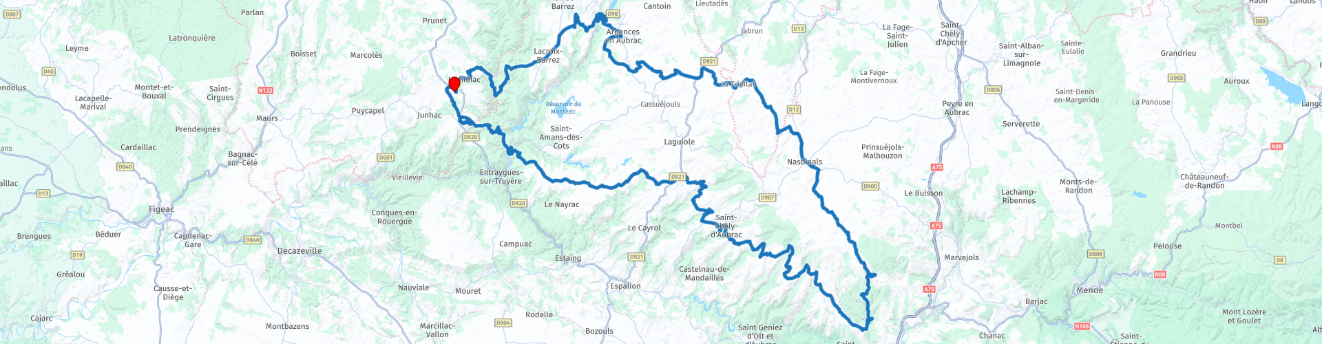
Roundtrip from Labesserette to the Aubrac plateau

Deze route is gemaakt door:
RouteXpert Catherine De Groote RouteXpert
Laatst gewijzigd: 21-11-2020
 Route Samenvatting
 Deze aparte entiteit, met een zeer sterke identiteit, werd in 2018 het Regionaal Natuurpark Aubrac. Een essentiële basis voor de toekomst van dit zeer bijzondere gebied.
Met zijn okerkleurige vacht, zijn grote liervormige hoorns die naar de lucht zweven en zijn ogen die lijken te bestaan uit kohl, is de Aubrac-koe onmiddellijk herkenbaar. Bekend om zijn schoonheid maar ook om zijn robuustheid, is het het symbool van het plateau.
Ver weg van het drukke toerisme kan je hier ten volle genieten van de rust.
 Deel deze route


Animation

Beoordeling


Duur
5h 48m

Transportmodus
Auto of motor

Afstand
241.22 km

Landen

 RouteXpert Review
 Vanaf het dorpje Montlogis rijd je door het bos. Alhoewel de baan redelijk smal is, is ze toch in goede staat. Je komt na 10 km terug in open landschap met mooie vergezichten. Verder daal je door het bos naar de Truèyre. Je steekt de rivier over aan de oude dam van het meer van Sarrans (RP 4). De eerste werken aan deze dam begonnen in 1914; stopgezet en vervolgens hervat in 1917, beleefden hun volledige activiteit in 1928 om in 1933 te eindigen met de ingebruikname van de Brommet-energiecentrale.
Stilaan kom je op het plateau van de Aubrac waar de weidse landschappen je laten genieten van de rust en kalmte. Er is hier weinig tot geen verkeer en bijna geen bewoning. Op de immense weiden grazen kuddes Aubrac-koeien. Deze koeien stellen niet veel eisen aan voedsel en zijn in staat mager voer van lage kwaliteit te eten voordat ze zichzelf tevreden stellen met het overvloedige gras. De dieren passen zich zeer goed aan het zomerseizoen aan. Vroeger werden Aubracs bewaakt door buronniers die ze melken om Laguiole en Tomme te produceren. Ze worden nu bijna uitsluitend gebruikt voor de vleesproductie, zowel in raszuivere dieren als in kruisingen met andere stieren. De moeder baart één kalf per jaar, meestal in volledige autonomie. De laatste is robuust vanaf de geboorte en brengt de eerste maanden van zijn leven door in de weilanden van Aubrac, bij zijn moeder. Een kudde bestaat dan ook uit koeien, kalveren en een stier.
In het landschap zie je hier en daar een stenen gebouw, bedekt met leisteen, de zogenaamde 'buron'. Ze werden gebruikt voor de productie van kaas: de cantal, de laguiole of fourme d'Aubrac, de Saint-Nectaire tijdens de zomer (van half mei tot half oktober), en om de buronniers te huisvesten. Ze getuigen van een manier van leven die inmiddels voorbij is. Sommige van deze 'burons' zijn nu een herberg/restaurant. Vanop de Pont de Gournier kan je de Bès-vallei en zijn rijkdom bewonderen (RP 9).
Net voor het binnenrijden van Nasbinals heb je mogelijkheid om lekker te eten in het restaurant 'Les Sentiers de l'aubrac' (RP 10). Je kan er proeven van authentieke gerechten, bereid volgens de traditie.
Nasbinals is een charmant dorpje, gelegen op een hoogte van 1.200 meter in het hart van Aubrac.
Vanaf hier verandert het landschap enigszins. De rotsen getuigen van de oude vulkanische activiteit van het plateau. Bij de Pont des Nègres (RP 11) kom je voorbij spectaculaire basaltkolommen, gemakkelijk waarneembaar vanaf de weg, gevormd uit een basaltgesteente dat in hexagonale prisma's is gebroken.
Een redelijk vlakke weg, kronkelend op het Aubrac-plateau brengt je van Nasbinals (1200 m) naar de Bonnecombe-pas (1469 m) (RP 12). Dit vormt de toegang tot het zuidelijk deel van de Aubrac-bergen, het hoogste punt van het plateau. Je rijdt naar Saint-Pierre de Nogaret, het keerpunt op deze route.
Saint-Chély-d'Aubrac is een charmant dorpje in de groene vallei van de Boralde in het Massif de l'Aubrac. De oude brug, bekend als 'Pont des Pèlerins' (RP 19), met twee bogen dateert van de middeleeuwen. De brug op de weg naar Saint-Jacques de Compostela, overspant de Boralde en is geclassificeerd als een cultureel erfgoed (UNESCO). Op de borstwering draagt een prachtig stenen kruis uit de 14de eeuw met in de schacht een bas-reliëf dat een pelgrim voorstelt, met zijn grote cape (pelgrim), zijn hommel (staf) en een grote rozenkrans.
Je blijft ook nu in een open landschap met maar enkele kleine bossen en zoals in dit ganse gebied overheerst de rust. Voor je terug aan de vakantiewoning bent, kan je nog even kennis maken met Monsalvy (RP 27). De stad werd aan het einde van de 11e eeuw gesticht rond een klooster. Het klooster van Saint-Gausbert heeft een kapittelzaal met een schat aan kantonale cultuskunst. De refter van de monniken herbergt een prachtig spitsbooggewelf met enkele sculpturen, evenals mooie kleine kolommen. Het kasteel van Montsalvy, een burgerlijke residentie, heeft nog steeds een prachtige toren uit de 15e eeuw.
Het landschap is zeer afwisselend: van bosgebied tot uitgestrekte vergezichten, kleine dorpen, meren en kronkelende rivieren. De wegen zijn voor 95% in uitstekende staat; enkel in de dichte bossen liggen ze wat hobbelig maar zijn toch aangenaam berijdbaar. Alhoewel deze streek vooral gekend is om zijn natuur, kom je hier en daar toch wel enkele bezienswaardigheden tegen die een stop waard zijn. Daarom krijgt deze rondrit dan ook 5 sterren.


 Links
Links  Gebruik
 Deze route downloaden?
Je kan de route gratis, zonder MyRoute-app account downloaden. Om dit te doen, open de route en klik op 'opslaan als'. Deze route wijzigen?
Geen probleem, open eerst de route. Volg de tutorial en maak je eigen MyRoute-app account aan. Na registratie, start je trial automatisch.  Disclaimer
Gebruik van deze gps-route is voor eigen rekening en risico. De route is met zorg samengesteld en door een MyRoute-app geaccrediteerde RouteXpert gecontroleerd voor gebruik op zowel TomTom, Garmin als MyRoute-app Navigation.
Door gewijzigde omstandigheden, wegomleidingen of seizoensafsluitingen kunnen er toch veranderingen zijn ontstaan. Daarom adviseren wij iedere route voor gebruik te controleren.
Gebruik bij voorkeur de routetrack in je navigatiesysteem. Meer uitleg over het gebruik van MyRoute-app kun je vinden op de website bij ‘Community’ of ‘Webinars’.