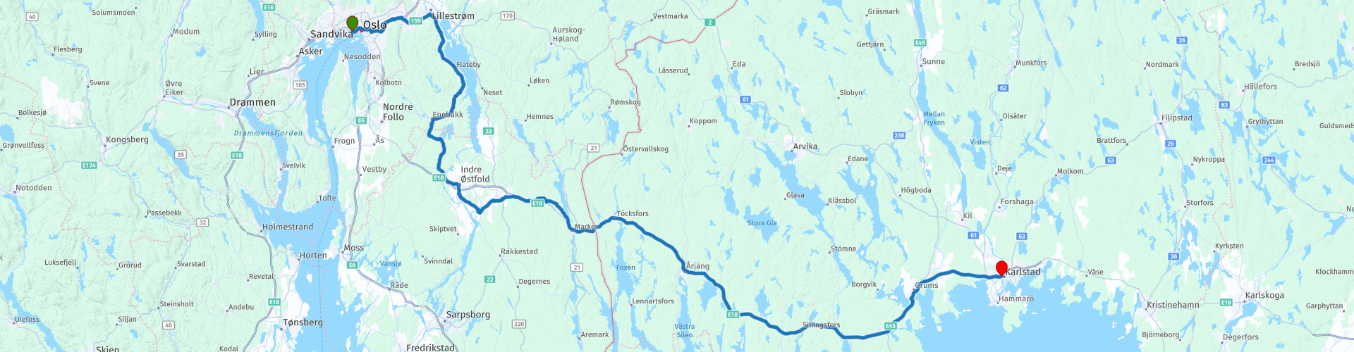
01 Oslo to Karlstad

Diese Route wurde erstellt von:
RouteXpert Leon Bodegom
Letzte Änderung: 22-02-2021
 Routenzusammenfassung
 Dies war der Beginn unserer Tour im Jahr 2019 und die Einführung in Schweden. Unterwegs gibt es viel zu sehen und zu besuchen. Beachten Sie jedoch die Öffnungszeiten der zu besuchenden Orte. Die Touristensaison ist kurz und an einigen Stellen wurden die Sehenswürdigkeiten manchmal erst nach Pfingstmontag geöffnet.
Schöne Straßen, Kurven, Seen, Flüsse, Heidekraut und Sümpfe wechseln sich mit Wäldern und grünen Hügeln ab. Und auch Bären, Luchse, Wölfe und Elche. Also musst du aufpassen.
Start: Hafen von Oslo, Colorline Terminal
Ende: Karlstad, Hotel Clarion Drott
Ich habe diese Route mit 3 *** Sternen ausgezeichnet, weil die Landschaft abwechslungsreich ist, die Straßen gut und die Attraktionen sehr gut.
 Diese Route teilen


Animation

Urteil


Dauer
9h 6m

Reisemodus
Auto oder Motorrad

Entfernung
254.74 km

Länder


 RouteXpert-Überprüfung
 In Norwegen sind die Hauptstraßen rund um Oslo alle mautpflichtigen Straßen, die für Motorradfahrer bis 2019 noch gebührenfrei waren. Wenn Sie mit dem Auto anreisen, werden Sie über automatische Mautstellen mit Kennzeichenregistrierung registriert und erhalten nach einigen Wochen oder Monaten, manchmal gar nicht, die Rechnung zu Hause. Die Kosten sind in der Regel nicht schlecht. Die Stadt Oslo ist sicherlich eine Stadt, in der man angesichts der Altstadt und der verschiedenen Museen mehrere Tage bleiben kann. Planen Sie hier zu Beginn oder am Ende Ihrer Tour ein paar zusätzliche Tage.
Nach ca. 25 Kilometern zweigt die Straße nach Süden ab und wir fahren parallel zum Fluss Nitelva. Dies sind die letzten Kilometer der 37 Kilometer langen Nitelva, die dann in die Glomma mündet. Dies verwandelt sich in einen großen See namens Oyeren und später passieren Sie die Glomma wieder. Der Fluss diente früher zum Transport von Baumstämmen zum Meer.
Nach der Brücke über die Glomma gibt es einen großen Parkplatz am Fluss, an dem Sie eine Pause einlegen und einen Blick auf die alte Brücke (Old Fossum Bru) werfen können. Hier sind auch Verteidigungen aus dem 2. Weltkrieg. Auf dem Parkplatz besteht auch die Möglichkeit einer Tasse Kaffee.
Nach ca. 100 km können Sie die monumentale Kirche in Eidsberg besuchen. Dies ist eine Kirche aus dem 13. Jahrhundert und eine der ältesten Steinkirchen in Schweden. Wenn die Kirche nicht geöffnet ist, wohnt der Hausmeister diagonal gegenüber und öffnet Ihnen gerne die Tür mit einem altmodischen Schlüssel von 30 cm Länge.
Ein Stück weiter, vor der Stadt Mysen, kommen Sie zum kleinen Freilichtmuseum Folkenborg. Weitere Informationen finden Sie unter dem Link unter dem Text. Die vielen (kleinen) Museen in Schweden und Norwegen sind durch das Symbol ⌘ Schleife auf weißen Wegweisern mit braunem Aufdruck gekennzeichnet. Kurz nach dem Folkenborg-Museum führt die Route durch Mysen an einem Kiosk mit Terrasse vorbei, auf dem Sie möglicherweise zu Mittag essen oder einkaufen können.
Die Höhenunterschiede in der Landschaft sind nicht spektakulär, aber genug, um hin und wieder auf einen Wasserfall zu stoßen.
Sie kommen am Susebakkefossen vorbei, wo sich ein altes Wasserkraftwerk befindet. Auf der anderen Seite der Brücke ist Platz für ein Foto.
Beim Betreten von Orje passieren Sie einen alten Schleusenkomplex im Halden-Kanal.
Dies ist einen Spaziergang wert und für eine Besichtigung. Hier befindet sich auch ein Museum zur Geschichte des Haldenkanals.
Sie passieren die Grenze zwischen Norwegen und Schweden und fahren zwischen Seen und Wäldern weiter nach Arjang. Auf einem Parkplatz steht eine große Statue eines Trolls.
Den letzten Teil fahren Sie durch die Provinz Varmland zum Endziel Karlstad. Varmland ist eines der schönsten Naturschutzgebiete in Schweden. Die schöne Natur rundet Ihren Motorradurlaub ab. Die Landschaft von Varmland ist sehr vielfältig: Seen, Flüsse, Heidekraut und Sümpfe wechseln sich mit Wäldern und grünen Hügeln ab. Mehr als 2/3 von Varmland besteht aus Wäldern. Es gibt mehr als 10.000 Seen in der Umgebung, die natürlich die Landschaft prägen. In den vielen Wäldern leben Bären, Luchse, Wölfe und Elche. Also musst du aufpassen.
Die Orte, an denen man unterwegs etwas essen oder trinken kann, sind begrenzt. Sie müssen oft in ein Dorfzentrum fahren, um Essen und Getränke zu erhalten. In Sanda gibt es einen Campingplatz auf dem Wasserweg mit Kiosk und Terrasse. Hier ist es angenehm, eine kurze Pause zu machen.
Bei der Einfahrt in Karlstad führt die Route entlang des Kreises K zum Tanken, damit Sie am nächsten Tag sofort vorwärts fahren können.
Für Campingbegeisterte wurden 2 Poi's von Campingplätzen im Wald und am Wasser vor Karlstad hinzugefügt.


 Links
Links  Nutzung
 Möchten Sie diese Route herunterladen?
Sie können die Route ohne MyRoute-App-Konto kostenlos herunterladen. Öffnen Sie dazu die Route und klicken Sie auf 'Speichern unter'. Möchten Sie diese Route bearbeiten?
Kein Problem, starten Sie mit dem Öffnen der Route. Folgen Sie dem Tutorial und erstellen Sie Ihr persönliches MyRoute-App-Konto. Nach der Registrierung startet Ihre Testversion automatisch.  Haftungsausschluss
Die Nutzung dieser GPS-Route erfolgt auf eigene Kosten und Gefahr. Die Route wurde sorgfältig von einem MyRoute-App akkreditierten RouteXpert für die Verwendung mit TomTom, Garmin und MyRoute-App Navigation zusammengestellt und geprüft.
Durch geänderte Umstände, Straßenumleitungen oder saisonale Sperren können sich dennoch Änderungen ergeben haben. Wir empfehlen daher, jede Route vor der Nutzung zu überprüfen.
Verwenden Sie vorzugsweise den Routentrack in Ihrem Navigationssystem. Mehr Informationen zu den Die Nutzung der MyRoute-App finden Sie auf der Website unter 'Community' oder 'Academy'.

Akershus
Über diese Region
Akershus (von altnordisch akr „Mark“ und hús „Haus“, hier als Burg verstanden) ist eine traditionelle Region in Norwegen mit Oslo als Zentrum. Akershus bezeichnet historisch sowohl einen großen Landesteil, der vom Mittelalter bis 1919 den größten Teil Ostnorwegens umfasste, als auch eine kleinere zentrale Provinz (Amt, ab 1919 Fylke) in der Großregion Oslo bis Ende 2019. Der größte Teil des modernen Oslo gehörte bis 1948 zu Akershus. Das Gebiet des ehemaligen Fylkes Akershus bildet auch nach der Regionalreform, bei der es in die neu geschaffene Provinz Viken überging, weiter einen Wahlkreis.
Lesen Sie mehr auf Wikipedia
Region anzeigen
 Statistik
  5
5Anzahl der RX-Bewertungen (Akershus)
 17917
17917Anzahl der Besucher (Akershus)
 483
483Anzahl der Downloads (Akershus)
 Routensammlungen in dieser Region
 In 12 Tagen von Oslo bis zum Nordkap
Dies ist eine Routensammlung einer Motorradtour von Oslo zum Nordkap, basierend auf einer Reise von Thomas Falck Østli. Insgesamt wurden zwölf Routen beschrieben, die Tour kann jedoch auf weitere Tage ausgedehnt werden. Weitere Informationen hierzu finden Sie in den Testberichten.
Die Routen führen durch die wunderschönen Landschaften Norwegens, einschließlich der Lofoten, mit vielen Seen, Fjorden, Flüssen, wunderschönen Brücken, wunderschönen grünen Wäldern und schroffen Bergen. Während der Fahrt gibt es auch viele Fährüberfahrten, berücksichtigen Sie dies bei Ihrer Planung.
Sie fahren längere Strecken in Norwegen, ohne auf eine Tankstelle oder ein Restaurant zu stoßen. Denken Sie daran, bevor Sie fahren. Stellen Sie sicher, dass Ihr Tank voll ist und bringen Sie Essen und Getränke mit. Bringen Sie ein paar Flaschen Wasser oder einen Kamelbeutel mit und füllen Sie ihn auf, wenn Sie aufhören zu tanken. Unterwegs sind Pausen zum Auftanken, Essen und Trinken geplant.
Die Gesamtstrecke von fast 3700 Kilometern ist wie folgt aufgeteilt:
• Tag 1 ist eine 434 Kilometer lange Fahrt von Oslo nach Geiranger
• Tag 2 ist eine 238 Kilometer lange Fahrt von Geiranger nach Kristiansund
• Tag 3 ist eine 298 Kilometer lange Fahrt von Kristiansund über Trondheim nach Verdal
• Tag 4 ist eine 333 Kilometer lange Fahrt von Verdal nach Brønnøysund
• Tag 5 ist eine 267 Kilometer lange Fahrt von Brønnøysund nach Furøy
• Tag 6 ist eine 296 Kilometer lange Fahrt von den Furøy Lofoten nach Reine
• Tag 7 ist eine 218 Kilometer lange Fahrt von Reine nach Ørsvågvær
• Tag 8 ist eine 274 Kilometer lange Fahrt von Ørsvågvær nach Straumsjøen
• Tag 9 ist eine 327 Kilometer lange Fahrt von Straumsjøen nach Senjahopen
• Tag 10 ist eine 321 Kilometer lange Fahrt von Senjahopen nach Tromsø
• Tag 11 ist eine 420 Kilometer lange Fahrt von Tromsø nach Alta
• Tag 12 ist eine 239 km lange Fahrt von Alta über das Nordkap nach Skarsvåg
Sie haben die Wahl, auf Campingplätzen oder in Hotels zu übernachten. Die Hotelpreise in Norwegen sind nicht besonders hoch und das Frühstück ist normalerweise inbegriffen.
Camping ist fast überall kostenlos, außer auf privatem Grund oder wo Camping verboten ist, angezeigt durch Verbotsschilder.
Wenn Sie nicht campen möchten, können Sie auf den Campingplätzen häufig Hütten mieten. Für eine Reise durch Norwegen ist es immer ratsam, ein Zelt und andere Campingausrüstung mitzubringen.
Informationen zu Hotels und Campingplätzen finden Sie in der Wegbeschreibung
Viel Spaß beim Lesen, Planen und Fahren dieser malerischen Reise an die nördlichste Spitze Europas.
Routensammlung anzeigen
6500 Kilometer durch Skandinavien mit den Highlights der Lofoten und des Nordkaps
Die Arctic Challenge Tour, auf der diese 26-teilige Tour teilweise basiert, ist kein Speed-Rennen. Es ist eine Tour. Es kommt auf Agilität, gute Navigation und Vorfreude an. Die Teilnehmer sind verpflichtet, das Tempolimit des jeweiligen Landes einzuhalten. Die Teilnehmer müssen unter 100-prozentiger Einhaltung der örtlich geltenden Verkehrsregeln die optimale Route mit möglichst kurzer Distanz finden. Berücksichtigen Sie dabei natürlich auch die Höchstgeschwindigkeiten. Die Organisation prüft auf Verstöße gegen das Tempolimit. Bei grober oder wiederholter Überschreitung der Höchstgeschwindigkeit erfolgt die Disqualifikation für die betreffende Etappe und für die Endwertung. Die Strecken- und Geschwindigkeitskontrolle erfolgt über ein Track-and-Trace-System. Dieses Gerät ist in jedem Fahrzeug verbaut. Sie können dann jedes Team im Back Office genau verfolgen. Daheimgebliebene, Interessierte und Teilnehmer können sich auch die Leistungen der Mannschaften ansehen, denn über das Internet können Sie live mitverfolgt werden. Das Back Office greift ein, wenn ein Team in Schwierigkeiten gerät. (Quelle: Website The Arctic Challenge)
Das ist schon ein Luxus, ein Backoffice hinter sich zu haben, das einen im Auge behält. Die meisten von uns werden das nicht haben und sind allein oder mit den Mitreisenden. Die einzige Vereinbarung, die Sie mit den Teilnehmern treffen, ist, dass Sie sich auch an die Regeln halten müssen. Zum Glück müssen Sie diese Tour nicht wie die Teilnehmer in 9 Tagen absolvieren, sondern können es auch etwas länger dauern.
Das Highlight der Arctic Challenge im Jahr 2020 waren die Lofoten, eine Inselgruppe nordwestlich von Norwegen. Der Lofoten-Archipel liegt mitten im wilden Norwegischen Meer, weit über dem Polarkreis. Diese besondere Region bietet eine wunderschöne Landschaft mit imposanten Bergen, tiefen Fjorden und langen, wilden Sandstränden, an denen immer das Geräusch der Seevogelkolonien zu hören ist.
Der Archipel ist vor allem für seine reiche Fischertradition bekannt. Die Lofoten machen trotz ihrer isolierten Lage einen wohlhabenden Eindruck. Die gesamte Wirtschaft dreht sich vor allem um die Fischerei. Das Bild der Lofoten wird hauptsächlich von Holzgestellen mit Kabeljau dominiert, der zum Trocknen aufgehängt wird. Die Fischerei auf den Lofoten ist seit Jahrhunderten ein Begriff. Mitten im Winter brachen die Schiffe in wenigen Monaten auf, um die Fische zu fangen. Die reichen Fischgründe sind dem nordatlantischen warmen Golfstrom rund um die Inseln zu verdanken, in dem die Fische ihre Laichgründe haben. Ölbohrungen sind rund um die Lofoten und die dortigen Kabeljau-Laichplätze nicht erlaubt.
Das nächste Ziel der Teilnehmer war Sirkka, auch bekannt als Levi, ein Wintersportort im finnischen Lappland. Dort blieben sie ein paar Tage, um Schlittschuh zu fahren und den Schnee bei einer Schneemobil- oder Skitour zu genießen. Diese Tour führt dich auch nach Sirkka, aber anstatt dort ein paar Tage zu bleiben, hast du die Möglichkeit zum Nordkap, dem zweiten Highlight dieser Reise, weiterzufahren.
Stellen Sie sich einen Ort im hohen Norden vor, wo der Atlantik auf das eisige Wasser des Arktischen Ozeans trifft. Dieser Ort ist das Nordkap in Westfinnmark in Nordnorwegen. Von hier aus liegt nur noch die Inselgruppe Spitzbergen zwischen Ihnen und dem Nordpol und die Sonne scheint jeweils 2,5 Monate lang; von Mitte Mai bis Ende Juli. Viele Besucher bewundern vom Nordkap-Plateau aus die Mitternachtssonne oder den Sonnenuntergang über der Barentssee.
Zu jeder Route finden Sie eine Bewertung mit einer Beschreibung der Route, wo Sie vorbeikommen und was es unterwegs zu sehen gibt. Es wird auch kurz beschrieben, wie es die Teilnehmer der Arctic Challenge 2020 sowieso fahren mussten, von welchem Punkt bis zu welchem Punkt. Unterwegs sind Markierungen (Routenpunkte) angebracht, die die Endpunkte der Etappen anzeigen, die die Teilnehmer absolvieren mussten. Wie bereits erwähnt, legten sie die Strecke in 9 Tagen zurück, Etappen von mehr als 1000 Kilometern waren da keine Ausnahme.
Jede Route endet an einem Hotel. Es ist natürlich keine Verpflichtung, diese Hotels zu nutzen, Sie können jederzeit eine andere Unterkunft in der Umgebung finden, die Entscheidung liegt bei Ihnen. Meine Erfahrung ist jedoch, dass es sich um einfache, aber gute Hotels zu einem sehr vernünftigen Preis handelt. Sie sind bekannt und können bei booking.com gebucht werden.
Die Routen dieser Sammlungen:
R01 - Puttgarden nach Ängelholm, 280km
R02 - Ängelholm nach Alingsas, 281km
R03 - Alingsas nach Mysen, 261km
R04 - Mysen nach Rena, 312km
R05 - Rena nach Orkanger, 306km
R06 - Orkanger nach Grong, 292km
R07 - Grong nach Mo i Rana, 290km
R08 - Mo i Rana nach Bodø, 231km
R09 - Rundtour Bodo zu den Lofoten Teil 1, 314km
R10 - Rundtour Bodo zu den Lofoten Teil 2, 250km
R11 - Rundtour Bodo zu den Lofoten Teil 3, 291km
R12 - Bodø nach Arjeplog, 295km
R13 - Arjeplog nach Jokkmokk, 244km
R14 - Jokkmokk nach Pajala, 239km
R15 - Rundtour Sirkka zum Nordkap Teil 1, 257km
R16 - Rundtour Sirkka zum Nordkap Teil 2, 300km
R17 - Rundtour Sirkka zum Nordkap Teil 3, 244km
R18 - Rundtour Sirkka zum Nordkap Teil 4, 275km
R19 - Rundtour Sirkka zum Nordkap Teil 5, 332km
R20 - Sirkka nach Kemi, 299km
R21 - Kemi nach Ylivieska, 251km
R22 - Ylivieska nach Jalasjarvi, 236km
R23 - Jalasjarvi nach Turku, 279km
R24 - Stockholm nach Askersund, 271km
R25 - Askersund nach Varnamo, 224
R26 - Varnamo nach Trelleborg, 259km
Viel Spaß beim Fahren dieser Strecken!
Routensammlung anzeigen