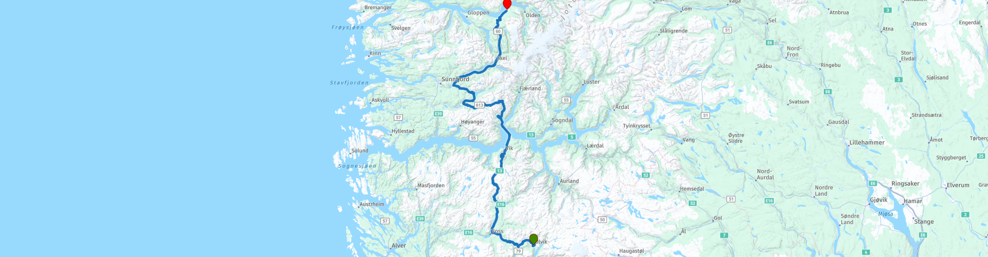
Rondreis Noorwegen - dag 3 Ulvik - Innvik

Questo percorso è stato creato da:
RouteXpert Bart De Medts
Ultima modifica: 18-04-2019
 Riepilogo percorso
 Punto di partenza: Hotel / B & B a Ulvik.
Punto finale del percorso: Hotel / B & B a Innvik.
Il percorso è stato lo stesso per gli utenti di navigazione TomTom, Garmin e MyRoute-app.
 Condividi questo percorso


Animation

Verdetto


Durata
5h 28m

Modalità di viaggio
Auto o moto

Distanza
283.88 km

Paesi

 Revisione RouteXpert
 Guidiamo su strade bellissime da Ulvik, via Voss, a Vangsnes. A Vangsnes prendiamo il traghetto attraverso il Sognefjord verso Dragsvik, e poi proseguiamo per Innvik.
Voss è un comune sul lago Vangsvatnet nella provincia norvegese di Hordaland. Ci sono aree sciistiche nella zona. In estate ci sono opportunità per sport acquatici e sport come il parapendio e il paracadutismo. C'è anche una cascata, la Tvindefossen, situata a 110 metri dalla E16.
A Vangsnes c'è una statua di 22 metri di Fridtjof den frøkne. Rappresenta il protagonista del vecchio norvegese Frithjofssaga. Questa scultura pomposa fu realizzata dallo scultore tedesco Max Unger e fu inaugurata nel 1913 alla presenza dell'imperatore Guglielmo II di Germania, che amava visitare questa regione con il suo yacht imperiale in estate (fonte: Wikipedia).
Nessun biglietto può essere acquistato in anticipo per il traghetto da Vangsnes a Dragsvik.
Non appena scendiamo dal traghetto guidiamo da Dragsvik, via Vassenden e Skei, a Innvik dove passiamo la notte al Fjordhotell.
Ci sono abbastanza opzioni di carburante sul percorso. Ti consiglio di acquistare un pranzo al sacco a Ulvik, sulla strada per Innvik incontrerai un sacco di bei posti picnic!
Perché non ho (ancora) guidato questa rotta da solo, otterrà 4 stelle.


 Collegamenti
  Utilizzo
 Vuoi scaricare questo percorso?
Puoi scaricare il percorso gratuitamente senza un account MyRoute-app. Per farlo, apri il percorso e fai clic su 'Salva con nome'. Vuoi modificare questa rotta?
Nessun problema, inizia aprendo il percorso. Segui il tutorial e crea il tuo account MyRoute-app personale. Dopo la registrazione, la tua prova inizia automaticamente.  Disclaimer
L'utilizzo di questo percorso GPS è a tue spese e rischio. Il percorso è stato accuratamente composto e controllato da un RouteXpert accreditato dall'app MyRoute per l'utilizzo su TomTom, Garmin e navigazione dell'app MyRoute.
Ciononostante potrebbero essersi verificati cambiamenti a causa di mutate circostanze, deviazioni stradali o chiusure stagionali. Si consiglia pertanto di controllare ciascun percorso prima dell'uso.
Utilizzare preferibilmente la tracklog del percorso nel sistema di navigazione. Maggiori informazioni sul l'uso dell'app MyRoute può essere trovato sul sito Web in 'Community' o 'Academy'.