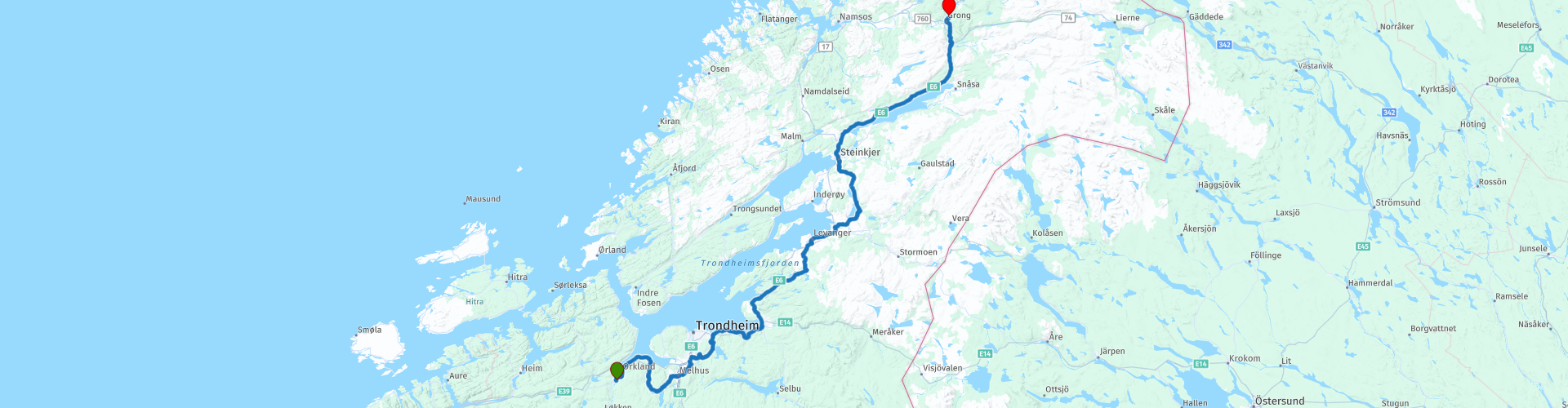
R06 Orkanger to Grong

Diese Route wurde erstellt von:
RouteXpert Arno van Lochem - Senior RX
Letzte Änderung: 20-05-2021
 Routenzusammenfassung
 Die Routen sind für jedermann leicht zu befahren und befinden sich auf gut asphaltierten Straßen. Möglicherweise muss eine einzelne Haarnadelkurve genommen werden, aber diese sind in Ordnung.
Befindet sich ein Stück Kies auf der Strecke, wird eine Warnung ausgegeben und ein Umweg angezeigt.
In diesem Teil der Tour sehen Sie wieder viel Wasser. Flüsse, kleine Seen, große Seen, einer schöner als der andere.
Die Route beginnt in Orkland und führt über Trondheim auf kleineren Straßen in Richtung und entlang der Küste. Von Zeit zu Zeit stoßen Sie auch auf eine etwas größere Durchgangsstraße. Genug Punkte auf dem Weg, um anzuhalten und ein Foto zu machen oder einfach die wunderschöne Natur zu genießen, die Norwegen zu bieten hat. Es gibt auch eine Reihe von Attraktionen wie das Fotomuseum und das Norwegen-Gebäude.
Das endgültige Ziel ist ein Hotel, aber es wurde auch an den Camper gedacht. Es gibt eine Reihe von Campingplätzen, auf denen Sie eine Wanderhütte oder ein Wandercamp mieten können.
Wunderschöne Landschaft, ausgezeichnete Straßen und schöne Sehenswürdigkeiten, daher die Bewertung von 4 Sternen.
 Diese Route teilen


Animation

Urteil


Dauer
8h 37m

Reisemodus
Auto oder Motorrad

Entfernung
291.96 km

Länder

 RouteXpert-Überprüfung
 Von allen westeuropäischen Ländern haben die skandinavischen Länder wahrscheinlich die mehr oder weniger unberührte Natur. Darüber hinaus handelt es sich um Länder, die von den Niederlanden aus leicht zugänglich sind. Norwegen zeichnet sich unter anderem durch die Fjorde und den Trollstigen aus, die vielen Motorradfahrern bekannt sind. Und wo Schweden als weit und entspannend bekannt ist, kennt jeder Finnland als das Land der 1000 Seen. Alles in allem legitime Gründe, diese wunderschöne Natur in Nordeuropa auf mehreren Wegen zu durchqueren.
Die Route beginnt in Orkanger an der nördlichsten Spitze des Ork-Tals. Kurz nach dem Start kommen Sie an einer Tankstelle mit einem ziemlich umfangreichen Supermarkt vorbei. Sie können dort Essen und Getränke für die Straße kaufen. Wenn Sie den Tank noch nicht gefüllt haben, können Sie dies auch hier tun.
Bevor Sie Orkanger hinter sich lassen, sollten Sie einen kurzen Abstecher entlang Thams-Paviljongen oder The Norway Building machen. Dieses Gebäude war Norwegens Beitrag zur Weltausstellung in Chicago im Jahr 1893. Nach 124 Jahren in den USA wurde das Gebäude nach Orkanger verlegt, wo es ursprünglich gebaut wurde. Während dieses Baus waren viele Holzschnitzer unter den 300 Arbeitern beschäftigt und sie trugen wesentlich zur Dekoration des Gebäudes bei.
Nach dieser Handwerkskunst verlassen Sie Orkangen und fahren einen langen Weg entlang der Küste nach Trondheim. Um der E39 mit ihren vielen Tunneln in Trondheim auszuweichen, verläuft die Route auf den kleineren Nebenstraßen entlang wunderschöner Seen, wo es schön ist, ab und zu anzuhalten, die Beine zu ziehen und ein schönes Bild zu machen.
Sie fahren unter Trondheim und müssen sich nur mit einem kleinen Stück bebauter Gebiete auseinandersetzen, dann finden Sie die kleineren Straßen schnell wieder und fahren durch das „Innere“.
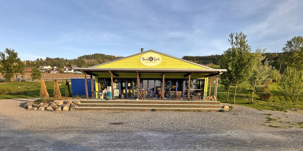
In Ranheim kehren Sie an die Küste zurück und es ist Zeit für eine Tasse Kaffee. Zumindest eine köstliche Tasse Kaffee mit Blick über das Wasser, wenn dieser blaue Schuppen nicht im Weg wäre ...
Nach dem Mittagessen fahren Sie zunächst wieder entlang der Küste auf einer etwas größeren Hauptstraße, gutem Asphalt und einer schönen Aussicht. In Størdal können Sie das Stjørdal Museum Værnes besuchen. Dies ist ein Freilichtmuseum im alten Pfarrhaus von Værnes. Das Museum basiert auf Martin Moes großer Sammlung von Antiquitäten und naturhistorischem Material. Im alten Pfarrhaus sind einige Zimmer mit antiken Möbeln und "Bauernmöbeln" aus dem 18. und 19. Jahrhundert eingerichtet. Das Pfarrhaus hat einen englischen Garten aus dem 19. Jahrhundert, der ebenfalls einen Besuch wert ist.
Sie fahren weiter nach Norden auf schönen, guten Straßen, die sich durch die hügelige Landschaft schlängeln. In Levanger, wo das Mittagessen geplant ist, haben Sie auch die Möglichkeit, das Levanger-Fotomuseum zu besuchen. Dies ist ein Fotogeschichtsmuseum, die für die Fotoerhaltung in Nord-Trøndelag zuständig ist. Das Museum hieß früher Levanger Museum, wurde aber 2016 umbenannt. Die Sammlung des Museums umfasst ungefähr 600.000 Negative und Objekte im Zusammenhang mit Fotografie. Die Sammlung besteht größtenteils aus Archiven einzelner Fotografen aus Levanger und Umgebung. Besonders hervorzuheben ist das Archiv von Harald Renbjør. Renbjør war Chemiker und Pionier in der Farbfotografie und verbrachte sein Leben damit, die Farbfotografie zu erforschen. Das Archiv nach ihm enthält Beispiele für die gängigsten Farbfotografietechniken wie Dreifarbenfotografie, Autochrom- und Agfa-Farbbildschirme. Das Chemielabor von Harald Renbjør wurde im Museum rekonstruiert.
Nach dem Mittagessen geht es weiter nach Norden, wieder entlang des Wassers. Der Vorteil dieser Arten von Küstenstraßen besteht darin, dass sie normalerweise die Konturen der (natürlich geformten) Seen bilden und daher mit vielen Kurven versehen sind. Und das ist hier nicht anders. Keine Strafe, diese Straße Kilometer für Kilometer kurvenreich zu nehmen.
Über den großen See Snåsavatnet, wo eine Kaffeepause geplant ist, erreichen Sie schließlich den heutigen Endpunkt, das Hotel Namsentunet in Grong. Ein charmantes Hotel in ländlicher Umgebung. Schön, dort zu bleiben. Ausgestattet mit einem Restaurant und einer Bar, also auch hier eine Bewertung des Tages bei einem Biergenuss.
In der Nähe des Endpunkts sind drei Campingplätze für Camper ausgeschildert: Bunesset, Langnes Camping und Værem Gård.
Viel Spaß beim Fahren dieser Route!

 Links
Links  Nutzung
 Möchten Sie diese Route herunterladen?
Sie können die Route ohne MyRoute-App-Konto kostenlos herunterladen. Öffnen Sie dazu die Route und klicken Sie auf 'Speichern unter'. Möchten Sie diese Route bearbeiten?
Kein Problem, starten Sie mit dem Öffnen der Route. Folgen Sie dem Tutorial und erstellen Sie Ihr persönliches MyRoute-App-Konto. Nach der Registrierung startet Ihre Testversion automatisch.  Haftungsausschluss
Die Nutzung dieser GPS-Route erfolgt auf eigene Kosten und Gefahr. Die Route wurde sorgfältig von einem MyRoute-App akkreditierten RouteXpert für die Verwendung mit TomTom, Garmin und MyRoute-App Navigation zusammengestellt und geprüft.
Durch geänderte Umstände, Straßenumleitungen oder saisonale Sperren können sich dennoch Änderungen ergeben haben. Wir empfehlen daher, jede Route vor der Nutzung zu überprüfen.
Verwenden Sie vorzugsweise den Routentrack in Ihrem Navigationssystem. Mehr Informationen zu den Die Nutzung der MyRoute-App finden Sie auf der Website unter 'Community' oder 'Academy'.