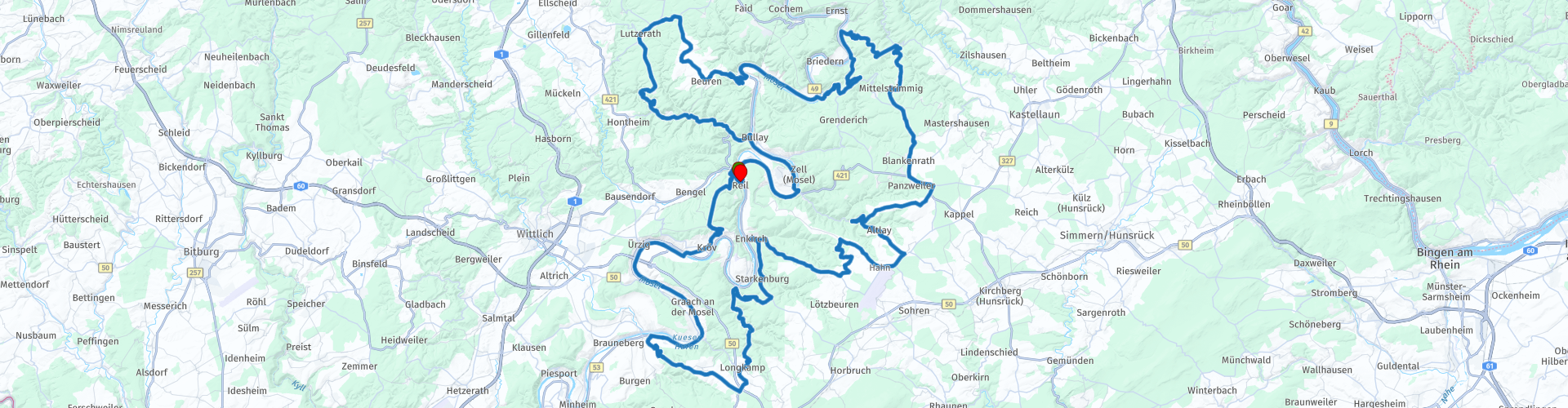
Rondrit Moezel Eifel en Hunsruck vanuit Reil

Cet itinéraire a été créé par:
RouteXpert Hans van de Ven (Mr.MRA)
Dernière modification: 09-11-2024
 Résumé de l'itinéraire
 Point de départ et d'arrivée : Motorherberg de Waard, Reil
Itinéraire fourni par : Wim Dekker
 Partager cet itinéraire


Animation

Verdict


Durée
6h 2m

Mode de déplacement
Voiture ou moto

Distance
196.73 km

Pays

 RouteXpert Review
 Sur le chemin de Reil à Kröv, vous arriverez bientôt à votre premier point de vue, où la Moselle serpente comme un serpent à travers la vallée. De ce point, vous pourrez admirer la rivière sinueuse, entourée de vastes vignobles et forêts. La vue s'étend jusqu'aux villes voisines de Wolf et Traben-Trarbach, vous offrant ainsi une vue panoramique sur la vallée de la Moselle. C'est un endroit idéal pour faire une pause et profiter des paysages époustouflants qu'offre la région mosellane.
À Bernkastel-Kues, vous découvrirez l'un des plus beaux vieux centres-villes d'Allemagne ; vous ne pouvez pas vous empêcher de vous arrêter et d'apprécier. Bernkastel-Kues est une charmante ville de la Moselle et est souvent considérée comme l'un des endroits les plus pittoresques de la région mosellane. La ville est connue pour son architecture médiévale bien conservée, avec ses maisons à colombages, ses ruelles étroites et sa place de marché historique qui semble tout droit sortie d'un livre de contes. Cette ville, qui se compose en réalité de deux parties - Bernkastel d'un côté et Kues de l'autre - est reliée par un pont sur la Moselle.
La place du marché est le cœur de Bernkastel avec ses maisons à colombages du XVIIe siècle, sa fontaine Renaissance et ses cafés chaleureux. La place dégage une atmosphère enchanteresse, surtout lorsqu'elle est éclairée la nuit ou lors du marché de Noël en hiver.
Les ruines du château de Landshut, ces ruines dominent la ville et offrent une vue spectaculaire sur Bernkastel, la Moselle et les vignobles environnants. Après une courte promenade, vous aurez un aperçu de l'histoire et du magnifique paysage. Bernkastel-Kues attire non seulement les randonneurs et les amateurs de vin, mais aussi les motocyclistes qui apprécient les routes sinueuses environnantes à travers la vallée de la Moselle et les montagnes voisines. La commune est une étape ou un point de départ idéal pour les aventuriers souhaitant découvrir la Moselle.
Puis un beau point de vue avec vue sur Traben-Trarbach et la vallée de la Moselle. Ce panorama offre une vue imprenable sur la Moselle serpentant à travers le paysage, entouré de collines couvertes de vignes et de zones boisées. Traben-Trarbach, connue pour son architecture Art nouveau et ses charmantes caves à vin, se dresse comme une ville pittoresque au bord de la Moselle, et de là vous pourrez admirer la ville et ses environs dans toute leur splendeur.
Ici, vous pouvez boire du café avec une vue imprenable.
Plus loin se profile Beilstein, un petit village pittoresque de la Moselle, surnommé la « Belle au bois dormant de la Moselle » en raison de son aspect romantique et de son architecture historique bien préservée. Avec ses charmantes maisons à colombages, ses ruelles étroites et l'imposant château de Metternich qui domine le village, Beilstein semble tout droit sorti d'un conte de fées. Cette ville pittoresque est très appréciée des touristes et des excursionnistes qui viennent pour son atmosphère unique et sa magnifique vue sur la Moselle.
Puis une belle vue sur la vallée de la Moselle près de Bremm et le célèbre Beerder Calmont, le vignoble le plus pentu d'Europe. De ce point, vous avez une vue imprenable sur la Moselle, qui serpente en une boucle abrupte à travers la vallée, entourée de pentes abruptes pleines de vignes. La rivière sinueuse et la verdure environnante en font l'un des plus beaux panoramas de la Moselle.
Et comme si cela ne suffisait pas, cet itinéraire vous emmène vers quelques-uns des joyaux cachés de la Moselle, où le paysage prend un éclat automnal, surtout en octobre.
La visite se termine à Reil, où vous pourrez regarder en arrière fatigué mais satisfait d'une journée pleine de vues à couper le souffle et de trésors historiques. Il ne s’agit pas de n’importe quelle voie ; c'est une ode à la Moselle et à ses secrets, parfaite aussi bien pour les solitaires que pour les groupes souhaitant vivre l'aventure ensemble.
Motorherberg de Waard est un hébergement attrayant spécialement pour les motocyclistes, situé dans le pittoresque village viticole de Reil, sur les rives de la Moselle. Le bâtiment, avec une histoire de plus de 300 ans, servait à l'origine de résidence au maire et a maintenant été transformé en une auberge confortable dotée d'équipements modernes.


 Liens
Liens  Utilisation
 Vous voulez télécharger cette route?
Vous pouvez télécharger l'itinéraire gratuitement sans compte MyRoute-app. Pour ce faire, ouvrez l'itinéraire et cliquez sur 'enregistrer sous'. Vous voulez éditer cette route?
Pas de problème, commencez par ouvrir la route. Suivez le tutoriel et créez votre compte personnel MyRoute-app. Après l'enregistrement, votre essai démarre automatiquement.  Avertissement
L'utilisation de cet itinéraire GPS est à vos propres frais et risques. L'itinéraire a été soigneusement composé et vérifié par un RouteXpert accrédité par MyRoute-app pour une utilisation sur TomTom, Garmin et MyRoute-app Navigation.
Des modifications peuvent néanmoins s'être produites en raison de circonstances modifiées, de déviations de routes ou de fermetures saisonnières. Nous vous recommandons donc de vérifier chaque itinéraire avant de l'utiliser.
Utilisez de préférence le tracé de l'itinéraire dans votre système de navigation. Plus d'informations sur le l'utilisation de MyRoute-app peut être trouvée sur le site Web sous 'Communauté' ou 'Académie'

Rheinland Pfalz
À propos de cette région
La Rhénanie-Palatinat (en allemand : Rheinland-Pfalz, /ˈʁaɪ̯nlant ˈp͡falt͡s/ ) est l'un des seize États fédérés composant l'Allemagne.
Elle a été créée le 30 août 1946 à partir de la partie nord de la zone française d'occupation et légalement confirmée par un référendum sur le projet de constitution le 18 mai 1947. Le jour de constitution du land est célébré chaque année le 18 mai.
Le land compte environ 4 000 000 habitants, dont 317 000 étrangers, sur une surface de 19 848 km2 soit une densité de 203 hab./km2.
Située à l'ouest du pays, la Rhénanie-Palatinat est frontalière avec trois pays européens et quatre autres länder allemands (depuis le nord et dans le sens des aiguilles d'une montre) la Rhénanie-du-Nord-Westphalie, la Hesse, le Bade-Wurtemberg, la France, la Sarre, le Luxembourg et la Belgique (Région wallonne).
En savoir plus sur Wikipedia
Elle a été créée le 30 août 1946 à partir de la partie nord de la zone française d'occupation et légalement confirmée par un référendum sur le projet de constitution le 18 mai 1947. Le jour de constitution du land est célébré chaque année le 18 mai.
Le land compte environ 4 000 000 habitants, dont 317 000 étrangers, sur une surface de 19 848 km2 soit une densité de 203 hab./km2.
Située à l'ouest du pays, la Rhénanie-Palatinat est frontalière avec trois pays européens et quatre autres länder allemands (depuis le nord et dans le sens des aiguilles d'une montre) la Rhénanie-du-Nord-Westphalie, la Hesse, le Bade-Wurtemberg, la France, la Sarre, le Luxembourg et la Belgique (Région wallonne).
Afficher la région
 Statistiques
  140
140Nombre de critiques RX (Rheinland Pfalz)
 48077
48077Nombre de visiteurs (Rheinland Pfalz)
 27841
27841Nombre de téléchargements (Rheinland Pfalz)
 Acheminer les collections dans cette région
 Top 5 des itinéraires en voiture et en moto dans l'Eifel
L'Eifel est la partie orientale du moyen plateau Eifel-Ardennes. Elle est située au nord de la Moselle et à l'ouest du Rhin. La plus grande partie est en Allemagne, une petite partie est en Belgique, dans les Cantons de l'Est. La partie allemande de l'Eifel est située dans les États fédéraux de Rhénanie du Nord-Westphalie et de Rhénanie-Palatinat. Le point culminant est le Hohe Acht avec 747 mètres.
Plusieurs chaînes peuvent être distinguées dans l'Eifel :
La partie la plus septentrionale s'appelle le Nordeifel, qui en Belgique se raccorde aux Hautes Fagnes ;
A l'est se trouve l'Ahrgebirge, cette partie est située au nord de l'Ahr dans le quartier Ahrweiler ;
Au sud de l'Ahr se trouve le Hohe Eifel (ou Hocheifel), dont le Hohe Acht (747 m) est le point culminant, et aussi le point culminant de toute la région de l'Eifel ;
À l'ouest, près de la frontière belge, les collines sont connues sous le nom de Schneifel, faisant partie de la zone plus large de l'Eifel des neiges avec des sommets atteignant 698 mètres ;
Au sud et à l'est du Hohe Eifel se trouve le Volcan-Eifel, une zone volcanique avec de nombreux lacs de cratère (Maare).
La partie sud de l'Eifel est moins haute. La région est traversée par des ruisseaux et des rivières qui coulent vers le sud. Ces ruisseaux se jettent dans la Moselle. Le plus grand de ces fleuves est le Kyll ; les collines autour de cette rivière sont connues sous le nom de Kyllwald ;
Au sud, l'Eifel se termine dans le Voreifel.
Au nord de l'Eifel, il y a quelques grands réservoirs. Le plus grand d'entre eux est le réservoir de la Roer qui a été créé par la construction du barrage de Roerdal.
Le Nürburgring est également situé dans l'Eifel, un circuit automobile bien connu pour les courses de Formule 1, entre autres. Depuis 2004, une partie du nord de l'Eifel est devenue le parc national de l'Eifel. Ce parc national fait entièrement partie du parc naturel germano-belge Hautes Fagnes-Eifel. Une autre partie de l'Eifel fait partie du parc naturel du sud de l'Eifel.
Connu dans tous les Pays-Bas et la Belgique en voiture et en moto, c'est donc une raison suffisante pour que l'application MyRoute RouteXpert compile pour vous un Top 5 des itinéraires en voiture et en moto.
Tous les itinéraires de cette collection ont été vérifiés et rendus égaux pour TomTom, Garmin et MyRoute-app Navigation par une MyRoute-app RouteXpert.
Si vous pensez que j'ai un très bel itinéraire qui ne devrait certainement pas manquer à cette collection, envoyez-le à :
email : routeexpert@myrouteapp.com
Sujet : Nouvelle route pour la collection Top 5 Eifel composée par Hans van de Ven.
Le parcours sera alors revu puis ajouté au Top 5. Pour que le Top 5 soit également le Top 5, 1 parcours devra disparaître du Top 5, vous pouvez l'indiquer lors de la soumission du nouveau parcours.
Amusez-vous avec cette collection et en conduisant l'un de ces itinéraires. Profitez de toute la beauté que l'Eifel a à offrir. Cliquez sur « Voir l'itinéraire » pour lire l'avis de l'itinéraire choisi.
J'aimerais connaître vos conclusions sur le(s) itinéraire(s).
Afficher la collection d'itinéraires
Route des épingles à cheveux de collection dans l'Eifel
Cette collection est composée des routes les plus belles et les plus sinueuses de l'Eifel. Oubliez Bundesstraßen, oubliez la route le long de la Moselle, si vous avez parcouru ces routes, vous pouvez vraiment dire que vous avez été dans l'Eifel.
Pas moins de 6 parcours et 1 800 kilomètres vous attendent !
Pas moins de 6 parcours et 1 800 kilomètres vous attendent !
Afficher la collection d'itinéraires