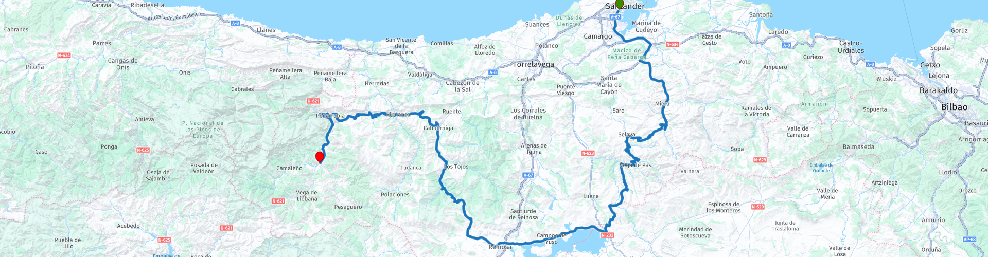
01 Santander to Potes

Questo percorso è stato creato da:
RouteXpert Nick Carthew - (MRA Master)
Ultima modifica: 02-04-2025
 Riepilogo percorso
  Condividi questo percorso


Animation

Verdetto


Durata
5h 59m

Modalità di viaggio
Auto o moto

Distanza
224.51 km

Paesi

 Revisione RouteXpert
 Il percorso utilizza la S10 per allontanarti rapidamente dal caos del trafficato porto dei traghetti ed è un po' insolito perché ti porta verso sud, attraverso l'enorme bacino dell'Ebro, dove la maggior parte degli altri percorsi ti porterebbero sulle autostrade A-67 e A-8 per dirigerti verso ovest fuori Santander.
Questo itinerario è incentrato su strade e panorami: dopo soli 15 minuti dalla partenza vi troverete nella campagna spagnola e dopo altri 30 minuti incontrerete strade di montagna e tornanti.
La catena montuosa Cantabrica è uno dei principali sistemi montuosi della Spagna. Si estende per oltre 300 km attraverso la Spagna settentrionale, dal limite occidentale dei Pirenei al massiccio galiziano in Galizia, lungo la costa del Mar Cantabrico.
Le strade tortuose sono un parco giochi naturale per le motociclette, con viste mozzafiato praticamente a ogni angolo.
Ci sono diversi punti in cui fermarsi per scattare foto, come indicato dai segnali verdi del percorso, ma a dire il vero, i panorami sono fantastici lungo la maggior parte del percorso.
Ho suggerito una sosta per mangiare o prendere un caffè sulle rive del possente bacino dell'Ebro. Il bacino dell'Ebro fu terminato da Franco nel 1945 per fornire migliori rifornimenti idrici alle aree a valle. I resti di 9 villaggi giacciono sotto le acque, anche se molti sono stati trasferiti a livello della riva. È un viaggio di circa 60 km e circa un'ora per circumnavigare il lago, e costituisce un viaggio interessante con molte cose in cui fermarsi e vedere. (Vale la pena ricordare)
Si inizia a dirigersi verso nord dopo il bacino idrico e si è presto a Puerto de Palombera, a 1260 metri è la parte più alta di questo percorso. Si trova anche all'interno del Parco Naturale Saja-Besaya e un'area che contiene alcune delle migliori foreste della Cantabria, che offrono riparo a una fauna preziosa, tra cui cervi, caprioli, cinghiali, lupi, camosci, vari uccelli rapaci, occasionalmente un orso bruno! Tenete gli occhi aperti.
L'ultima strada per Potes contiene il Desfiladero de La Hermida, una gola incredibile e lunga 20 km, la più lunga della penisola iberica. Il fiume Deva scorre al suo interno, fiancheggiato da pareti rocciose che raggiungono i 600 metri di altezza, il che rende la gola un vero spettacolo panoramico e un ottimo modo per concludere il primo giorno di questo tour di nove giorni.
A Potes ci sono moltissimi hotel e tutti i tipi di sistemazioni; sotto questa recensione ho inserito i link solo per alcuni di essi.
Godere.


 Collegamenti
  Utilizzo
 Vuoi scaricare questo percorso?
Puoi scaricare il percorso gratuitamente senza un account MyRoute-app. Per farlo, apri il percorso e fai clic su 'Salva con nome'. Vuoi modificare questa rotta?
Nessun problema, inizia aprendo il percorso. Segui il tutorial e crea il tuo account MyRoute-app personale. Dopo la registrazione, la tua prova inizia automaticamente.  Disclaimer
L'utilizzo di questo percorso GPS è a tue spese e rischio. Il percorso è stato accuratamente composto e controllato da un RouteXpert accreditato dall'app MyRoute per l'utilizzo su TomTom, Garmin e navigazione dell'app MyRoute.
Ciononostante potrebbero essersi verificati cambiamenti a causa di mutate circostanze, deviazioni stradali o chiusure stagionali. Si consiglia pertanto di controllare ciascun percorso prima dell'uso.
Utilizzare preferibilmente la tracklog del percorso nel sistema di navigazione. Maggiori informazioni sul l'uso dell'app MyRoute può essere trovato sul sito Web in 'Community' o 'Academy'.

Cantabrie
Informazioni su questa regione
La Cantabria è una comunità autonoma della Spagna, coincidente con l'omonima provincia.
Confina a est con i Paesi Baschi (provincia di Biscaglia), a sud con la Castiglia e León (province di León, Palencia, e Burgos), a ovest con le Asturie, e a nord con il mar Cantabrico. Il suo capoluogo è Santander.
La Cantabria appartiene geograficamente alla cornice Cantabrica, il nome dato alla frangia di terra situata tra il mar Cantabrico e la Cordigliera Cantabrica nel nord della penisola iberica.
Possiede un clima oceanico umido e con temperature moderate, fortemente influenzato dai venti dell'oceano Atlantico che si scontrano contro le montagne della cordigliera cantabrica. Le precipitazioni medie si aggirano sui 1 200 mm l'anno. La vegetazione è per questo florida e la regione si presenta al visitatore con un colore verde acceso per molti mesi all'anno.
La Cantabria è la regione più ricca del mondo di siti archeologici del Paleolitico Superiore. I primi segni di presenza umana risalgono al Paleolitico Inferiore, sebbene di questo periodo non resti molto nella regione. Spiccano in questo contesto i graffiti preistorici della grotta di Altamira, datati tra il 16 000 e il 9 000 a.C. e dichiarati Patrimonio dell'umanità dall'UNESCO. La Cantabria condivide inoltre il Parco nazionale dei Picos de Europa con le Asturie e la Provincia di León.
La moderna provincia della Cantabria si costituì il 28 luglio 1778. La Ley Orgánica del Estatuto de Autonomía de Cantabria venne approvata il 30 dicembre 1981, dotando così la comunità autonoma di organismi e istituzioni di autogoverno.
Diversi autori hanno studiato l'etimologia del nome della Cantabria. Pur non essendo sicura la sua provenienza, l'opinione più condivisa dagli esperti è che deriva dalla radice cant-, di origine celta o ligure e che significa “roccia” o “pietra”, e il sufisso -abr, usato frequentemente nelle regioni celtiche. Di tutto questo si pensa che cántabro significa “paese che abita nelle montagne”. È una delle regioni spagnole con la toponimia più antica, il termine “cántabro” appare per prima volta nelle fonti romane del secolo II a.C. dall'autore Catone il Vecchio.
Leggi di più su Wikipedia
Confina a est con i Paesi Baschi (provincia di Biscaglia), a sud con la Castiglia e León (province di León, Palencia, e Burgos), a ovest con le Asturie, e a nord con il mar Cantabrico. Il suo capoluogo è Santander.
La Cantabria appartiene geograficamente alla cornice Cantabrica, il nome dato alla frangia di terra situata tra il mar Cantabrico e la Cordigliera Cantabrica nel nord della penisola iberica.
Possiede un clima oceanico umido e con temperature moderate, fortemente influenzato dai venti dell'oceano Atlantico che si scontrano contro le montagne della cordigliera cantabrica. Le precipitazioni medie si aggirano sui 1 200 mm l'anno. La vegetazione è per questo florida e la regione si presenta al visitatore con un colore verde acceso per molti mesi all'anno.
La Cantabria è la regione più ricca del mondo di siti archeologici del Paleolitico Superiore. I primi segni di presenza umana risalgono al Paleolitico Inferiore, sebbene di questo periodo non resti molto nella regione. Spiccano in questo contesto i graffiti preistorici della grotta di Altamira, datati tra il 16 000 e il 9 000 a.C. e dichiarati Patrimonio dell'umanità dall'UNESCO. La Cantabria condivide inoltre il Parco nazionale dei Picos de Europa con le Asturie e la Provincia di León.
La moderna provincia della Cantabria si costituì il 28 luglio 1778. La Ley Orgánica del Estatuto de Autonomía de Cantabria venne approvata il 30 dicembre 1981, dotando così la comunità autonoma di organismi e istituzioni di autogoverno.
Diversi autori hanno studiato l'etimologia del nome della Cantabria. Pur non essendo sicura la sua provenienza, l'opinione più condivisa dagli esperti è che deriva dalla radice cant-, di origine celta o ligure e che significa “roccia” o “pietra”, e il sufisso -abr, usato frequentemente nelle regioni celtiche. Di tutto questo si pensa che cántabro significa “paese che abita nelle montagne”. È una delle regioni spagnole con la toponimia più antica, il termine “cántabro” appare per prima volta nelle fonti romane del secolo II a.C. dall'autore Catone il Vecchio.
Visualizza regione
 Statistiche
  15
15Quantità di recensioni RX (Cantabrie)
 19560
19560Quantità di visitatori (Cantabrie)
 1699
1699Quantità di download (Cantabrie)
 Indirizza le collezioni in questa regione
 Tre tour nei Picos de Europa e nei dintorni della Spagna settentrionale
I Picos de Europa sono una zona montuosa nel nord della Spagna, vicino ai Paesi Baschi. Nel mezzo c'è il villaggio di Posada de Valdeon, che non può essere raggiunto in moto da nord: devi guidare intorno ai Picos via Potes o Sames. Abbiamo pernottato a Posada de Valdeon nell'Hostal Casa Abascal. Un ottimo hotel con opzione per la colazione. Si può mangiare in un ristorante del paese con solitamente una scelta tra due menù.
Ci sono tutti i tipi di riserve naturali intorno ai Picos. Questi tre percorsi ti portano attraverso alcuni di essi. Ci sono gole da vedere, punti panoramici, bacini idrici e puoi camminare più che bene. Se ti piace camminare, porta le tue scarpe da passeggio.
Ma veniamo a cavalcare e sta andando alla grande. Strade eccellenti con occasionali tratti di sterrato per non dover deviare lontano per un'altra attrazione. Puoi mangiare cibo delizioso e le persone sono molto gentili e ospitali. E poiché la strada per Lourdes va al di sopra dei Picos, ci sono anche luoghi di pellegrinaggio e chiese e monasteri molto belli. La cosa più bella di questa zona è la natura: di una bellezza mozzafiato con animali selvatici, aspre montagne e fiumi selvaggi.
Tutto sommato, puoi passare almeno 4 giorni qui se ti prendi un giorno di riposo o fai una passeggiata.
Visualizza raccolta percorsi
Da Santander a Roscoff via Picos de Europa Pirenei costa occidentale della Francia
Un tour con 9 percorsi che si collegano tutti, partendo dal porto dei traghetti di Santander fino a Potes, utilizzando molte strade tortuose. Il percorso successivo è un giro davvero memorabile da Potes dei sempre popolari Picos de Europa. Quindi il tour si dirige a sud e a est oltre i bacini idrici e raccoglie il possente fiume Ebro e lo segue fino a Miranda de Ebro. Il percorso 4 prosegue verso est verso i Pirenei con strade più tortuose fino alla destinazione di Sos del Rey Catolico, un fantastico villaggio fortificato in cima a una collina. Il percorso successivo ti porta oltre i Pirenei con la possibilità di un giro in funivia su una montagna per pranzo. Il percorso 6 è il primo giorno in Francia ed è un piacevole giro oltre campi di girasoli e mais, foreste di pini e attraverso il Parco naturale regionale delle Landes de Gascogne. Quindi attraversi il possente estuario della Gironda in traghetto e ti dirigi verso il traguardo nella famosa città costiera di La Rochelle. Siamo rimasti per due notti a La Rochelle per provare le delizie di questa deliziosa città. La Route 7 costeggia la costa mentre viaggia verso nord e poi attraversa il possente fiume Loira per una notte a Saint Nazaire. La Route 8 inizia con una visita ai depositi dei sottomarini U-Boot a Saint Nazaire, poi attraverso i "campi" di produzione del sale di Guerande e verso Concarneau, un'altra città murata storica che deve essere visitata. L'ultimo percorso ti porta a Pointe du Raz e poi a Locronan, un villaggio medievale elencato come uno dei borghi più belli della Francia. Poi attraversa il ponte di Térénez, il primo ponte strallato curvo al mondo. Quindi entri e viaggi attraverso il Parco naturale regionale dell'Armorique per trascorrere la notte in un hotel B&B a Morlaix pronto per un breve viaggio al mattino per prendere il traghetto a Roscoff.
Visualizza raccolta percorsi