Roundtrip from North Bristol via Wye Valley and Brecon Beacons National Park

This route was brought to you by:
RouteXpert Ian Street
Last edit: 19-05-2021
 Route Summary
  Share this route


Animation

Verdict


Duration
5h 19m

Mode of travel
Car or motorcycle

Distance
198.35 km

Countries

 RouteXpert Review
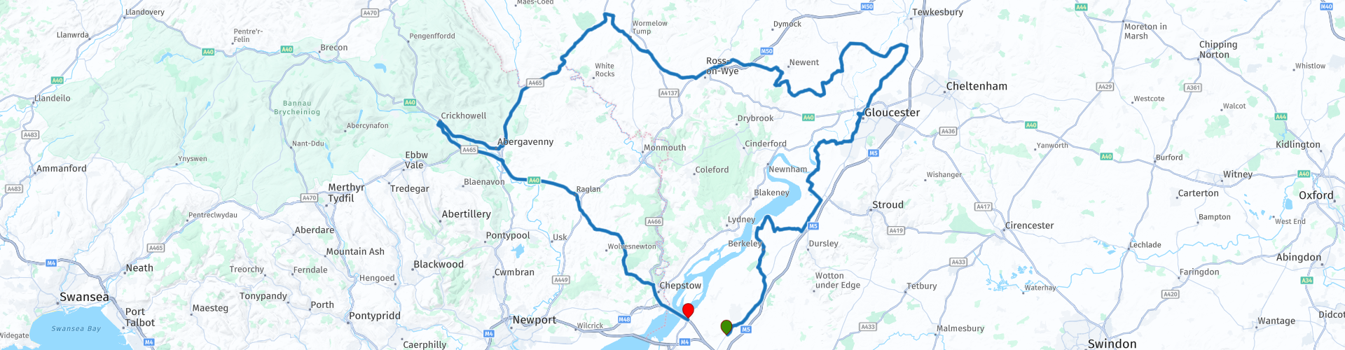
 Well, we start this ride from the Mason Arms public house, which is situated on the main A38, not far north off the M5 motorway (J16). There is a BP petrol station about halfway between the M5 motorway Junction and the Masons Arms. The Masons Arms has a good size car park with a good firm surface, the pub is a chain pub which serves fair price meals, so ideal for a nice all you can eat breakfast before you start.
The start of the route takes you north through some the little back roads near Sharpness and close to the rear of the Slimbridge wetlands centre. The roads here and on other section of the route are suitable for all bikes as there is no off-road sections, but you will get them dirty as there is a fair few farm roads. The speed limits range from 20mph up to the national speed limit, but caution must be taken as these are small country roads with some farm vehicles around. As you travel from the start RP No 1, to RP No 9, you will see some castles, museums and other POI, all which can provide good stopping off points, I have included them on this route as something to see, but this could be for another day as you may just want to enjoy the scenery. As you go through from RP’s 6 - 8, you may be lucky to see some of the birds coming and going from Slimbridge, Wildfowl & Wetlands as you pass close by. There is an admission cost to visit the WWT Centre, RP 9, please see their Website for further info.
The Stables Cafe, Sandfield Bridge, Canal Bank, Saul, RP 10, is next to another bridge over the Gloucester & Sharpness Canal and where it meets the Stroudwater Canal, while here you may be very lucky to see some tall ships, as Saul junction is on the route that the tall ships take from the River Severn to Gloucester docks a few miles up the canal. Today the junction is still popular with boaters and there are many lovely walks along the idyllic
waterways. A short walk away is Saul Junction Marina and Saul Junction Visitor Centre. The centre is run by the Cotswold Canals Trust. There is PAY & DISPLAY in operation.
There are another two stopping off points to see some birds, RP 14, the Barn Owl centre, which I have only marked down for information and RP 20, the International Centre for Birds of Prey, near Newent, Gloucestershire. They have over 200 birds of prey and more than 75 different species to see up close, some of which are critically endangered. The site boasts 3 daily flying demonstrations and fantastic opportunities for taking photos. This site charges an admission fee to enter, please see their Website for further info.
Locks garage near Allensmore, Hereford, RP 23, is a fantastic place to stop off for an ice cream. The larger than normal ice creams are the staggering price of £1.25 each and this includes a flake. (Dec 2020)
If you ride often in the Brecon Beacons national park, you will have passed along the A40 and straight past the little bottle neck of Crickhowell on to the bigger places in mid Wales, or you will have just stopped at the Oasis snack bar in the Abergavenny bus station. Either way Crickhowell RP 27 is a lovely little place to stop with its selection of public houses, cafes and quirky little shops. While here it is worth walking to see Crickhowell bridge, RP 28, the present structure, is the longest stone bridge in Wales.
As we ride back, we go through the village of Raglan and close to Raglan Castle, you know - that old building to your right as you fly down the A40 to get a coffee in Abergavenny from Gloucester, it’s well worth a visit. Raglan Castle the unmistakable silhouette of Raglan crowning a ridge amid glorious countryside is the grandest castle ever built by Welshmen.
Starting point: The Masons Arms, 94 Gloucester Road, Rudgeway, Bristol BS35 3QJ
End point: Severn View services, M48, J1.


 Links
Links  Usage
Usage Want to download this route?
You can download the route for free without MyRoute-app account. To do so, open the route and click 'save as'. Want to edit this route?
No problem, start by opening the route. Follow the tutorial and create your personal MyRoute-app account. After registration, your trial starts automatically.  Disclaimer
Use of this GPS route is at your own expense and risk. The route has been carefully composed and checked by a MyRoute-app accredited RouteXpert for use on TomTom, Garmin and MyRoute-app Navigation.
Changes may nevertheless have occurred due to changed circumstances, road diversions or seasonal closures. We therefore recommend checking each route before use.
Preferably use the route track in your navigation system. More information about the use of MyRoute-app can be found on the website under 'Community' or 'Academy'.

West Midlands
About this region
The West Midlands is a metropolitan county and combined authority area in western-central England with a 2020 estimated population of 2,939,927, making it the second most populous county in England after Greater London. It appeared as a metropolitan county in 1974 after the passage of the Local Government Act 1972, to cover parts of Staffordshire, Worcestershire and Warwickshire. The county is a NUTS 2 region within the wider NUTS 1 region of the same name. It embraces seven metropolitan boroughs: the cities of Birmingham, Coventry and Wolverhampton, and the boroughs of Dudley, Sandwell, Solihull and Walsall.
Read more on Wikipedia
View region
 Statistics
  15
15Amount of RX reviews (West Midlands)
 15898
15898Amount of visitors (West Midlands)
 2254
2254Amount of downloads (West Midlands)
 Route Collections in this region
 5 days through Wales on roads less travelled
As the title suggests, this is a 5 day tour through Wales on 'roads less travelled'. Each daily route has spectacular scenery through sometimes, dramatic landscapes. The tour visits some of Wales' well known sights and some not so well known. It travels across open moorland, deep valleys, the mountains of Snowdonia National Park and the beautiful countryside and coast. You will travel over historic bridges and see historic buildings and sights. This truly is an adventurous tour that I am certain you will enjoy.
View Route Collection
Top 10 Downloaded UK routes by RouteXpert Nick Carthew
Hello and welcome to this collection of the Top 10 MyRoute app downloaded routes in the UK.
There will be a great new event to be announced soon, where all these routes can be ridden.
Download them all now and place them in a new "Top 10" folder, so that you always have them at hand.
If you are going to drive one of these routes in the meantime, track them with the MRA Mobile App or with MRA Navigation. Take some photos (moments) along the way as these will come in handy.
Create a travelstory of your Top 10 driven routes and add the recorded track to it.
There will also be some great prizes on offer, so keep an eye on the MRA-RouteXperts page and your email.
View Route Collection