TTT 2015 01 Spijkenisse Oud Beijerland

Diese Route wurde erstellt von:
RouteXpert Hans van de Ven (Mr.MRA)
Letzte Änderung: 19-04-2021
 Routenzusammenfassung
 Die 173 ANWB Promoter TankTasTocht (TTT) wurden von Henry ten Dam gescannt und von Leon Stolk in Mapsource signiert und später als Track in einer .gpx-Datei abgelegt. Diese wurden mit Genehmigung des ANWB-Promoters über die MrGPS-Website zur Verfügung gestellt, damit jeder sie genießen kann. Der 1. TTT stammt aus dem Jahr 1992, daher kann die Route geringfügig vom Original abweichen.
Ich habe alle Routenpunkte überprüft und bei Bedarf ordentlich auf der Straße platziert. Bei Bedarf habe ich auch den Start- und Endpunkt der Route weiter voneinander entfernt, um ein direktes Navigieren zum Endpunkt zu vermeiden. Außerdem habe ich die POI-Dateien vom Start- und Endpunkt aus wie einen möglichen Haltepunkt hinzugefügt.
Schließlich habe ich die Route für TomTom-, Garmin- und MyRoute-App-Navigationsbenutzer identisch gemacht.
Vielen Dank an Henry, Leon, MrGPS und Promoter.
 Diese Route teilen


Animation

Urteil


Dauer
3h 55m

Reisemodus
Auto oder Motorrad

Entfernung
118.14 km

Länder

 RouteXpert-Überprüfung
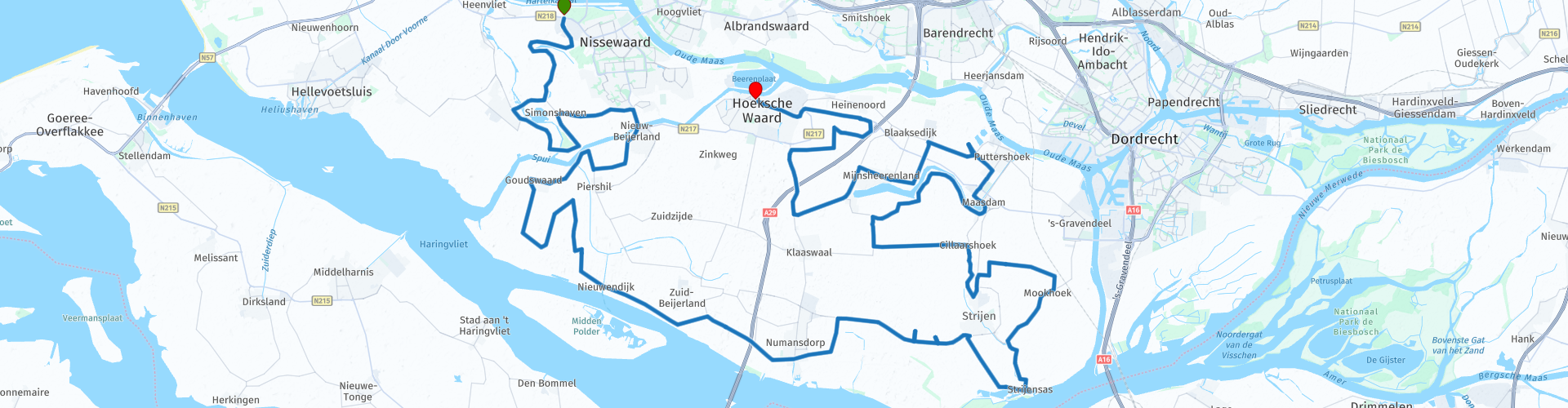
 Kurz nachdem Sie Sppijkenisse verlassen haben, passieren Sie die Bernisse, die von der Spui zum Schifffahrts- und Ernährungskanal führt, der parallel zum Hartelkanal verläuft. Unmittelbar danach können Sie ein Foto im Arend machen, einer Getreidemühle aus dem Jahr 1844 in der südholländischen Stadt Zuidland. Die weiß verputzte Rundstein-Gerüstmühle befindet sich am Molendijk. Pieter de Gilde beauftragte Dirk David van Dijk mit dem Bau der Mühle als Ersatz für eine ausgebrannte Holzmühle.
Wir fahren weiter und passieren normalerweise die Bernisse und dann die Spui. Dies ist ein Gezeitenfluss in Südholland, der die Verbindung zwischen der Oude Maas und dem Haringvliet bildet. Das Spui bildet die Trennung zwischen den Inseln Voorne-Putten und Hoeksche Waard. Die Spui entstand infolge der Sturmflut vom 2. November 1532, wobei die Verbindung der Spui mit der (Oude) Maas durch einen Deichbruch zustande kam. Wir fahren weiter und kurz bevor wir Kaffee trinken, können Sie am Dirty Hole ein paar Bilder machen. Dies ist der Wasserabschnitt zwischen Zuid-Beijerland / Nieuwendijk und der Insel Tiengemeten. Das Vuile Gat verbindet Ost und West mit dem Haringvliet. Eine Fähre überquert die Vuile Gat von Nieuwendijk zur Naturinsel Tiengemeten.
Nach der Kaffee- / Mittagspause in Numansdorp passieren wir die Sassenplaat, eine unbewohnte Insel im holländischen Diep in der Nähe des Hafen- und Industriegebiets Moerdijk in der Gemeinde Moerdijk, die als Naturschutzgebiet von Staatsbosbeheer geführt wird. Dann können Sie einige Vögel im Oudeland von Strijen beobachten, das hauptsächlich für die Zwerggänse bekannt ist, die dort jedes Jahr überwintern. Aber auch Rothalsgänse und kleine Schilfgänse sind hier ab und zu zu sehen, und zwar die häufigsten Wildgänse, Graugänse und Nonnengänse. Der Aussichtspunkt ist eine alte restaurierte Pumpstation mit einem schönen Blick über die kleinen Gewässer und die feuchte Wiese. Es gibt eine Informationstafel, einen Picknicktisch und eine Toilette.
Wir setzen unseren Weg fort und passieren nacheinander die Orte Maasdam, Puttershoek, Mijnsheerenland und Westmaas. In Heinenoord an der N217 sehen Sie die Statue der Mutter auf der anderen Straßenseite. Dies ist ein Kriegsdenkmal an der Stelle, an der am 28. Februar 1945 zehn Menschen erschossen wurden, als Vergeltungsmaßnahme für den Mord an dem NSB-Bürgermeister MA Simonis.
Nach weiteren 6 km erreichen wir die Endstation in Oud-Beijerland, wo Sie auf der Terrasse in aller Ruhe einen Drink genießen können.
Da ich diese Strecke (noch) nicht selbst gefahren bin, erhält diese Strecke 3 Sterne.
Routendetails:
RP 4 - Der Adler
RP 17 - Das schmutzige Loch
rp 18 - t Schippershuis. - Kaffee / Mittagspause
rp 23 - Die Sassenplaat
rp 29 - Das Oudeland von Strijen
RP 41 - Mutter


 Links
Links  Nutzung
 Möchten Sie diese Route herunterladen?
Sie können die Route ohne MyRoute-App-Konto kostenlos herunterladen. Öffnen Sie dazu die Route und klicken Sie auf 'Speichern unter'. Möchten Sie diese Route bearbeiten?
Kein Problem, starten Sie mit dem Öffnen der Route. Folgen Sie dem Tutorial und erstellen Sie Ihr persönliches MyRoute-App-Konto. Nach der Registrierung startet Ihre Testversion automatisch.  Haftungsausschluss
Die Nutzung dieser GPS-Route erfolgt auf eigene Kosten und Gefahr. Die Route wurde sorgfältig von einem MyRoute-App akkreditierten RouteXpert für die Verwendung mit TomTom, Garmin und MyRoute-App Navigation zusammengestellt und geprüft.
Durch geänderte Umstände, Straßenumleitungen oder saisonale Sperren können sich dennoch Änderungen ergeben haben. Wir empfehlen daher, jede Route vor der Nutzung zu überprüfen.
Verwenden Sie vorzugsweise den Routentrack in Ihrem Navigationssystem. Mehr Informationen zu den Die Nutzung der MyRoute-App finden Sie auf der Website unter 'Community' oder 'Academy'.