Havelterbergroute Drenthe

This route was brought to you by:
RouteXpert Hans van de Ven (Mr.MRA)
Last edit: 25-10-2019
 Route Summary
  Share this route


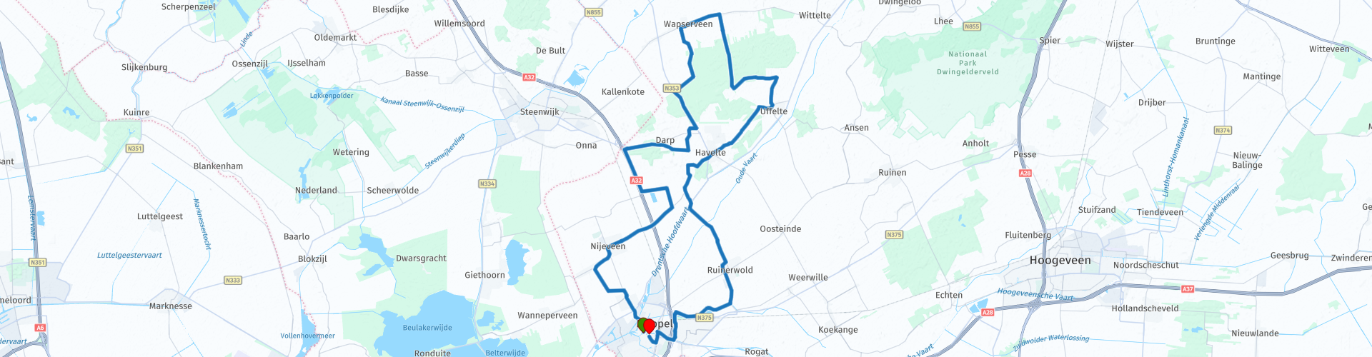
Animation

Verdict


Duration
3h 10m

Mode of travel
Bicycle

Distance
53.91 km

Countries

 RouteXpert Review
 This cycle route is signed in the "OpenStreetMap" map and can be used in navigation systems and / or can be printed with directions, via "Save as" and then choose .pdf.
Along the way you come by, or you cycle through:
Meppel
Meppel originated as an agricultural settlement at the confluence of a number of previously navigable watercourses, namely the Reest, the Wold Aa and the Havelter Aa. The city owes its rise to inland shipping. Large-scale painting took place from the 15th century. In 1460, Bishop David of Burgundy established two free annual fairs. Thanks to these markets and the venture, Meppel grew into a prosperous trading place.
The former city wagon on Kerkplein served until 1796. The reformed church was completed in the 15th century. Many canals and canals, which were so decisive for the cityscape, have unfortunately disappeared since 1919. Meppel has many beautiful examples of civil and industrial architecture such as mansions on Hoofdstraat, Kruisstraat or Zuideinde and the lime kilns on Steenwijkerstraatweg (off route).
Kolderveen
The regional village of Kolderveen was established around 1200 as a peat peat extraction. The village has a simple brick hall church that was completed in 1471. The church is very nicely situated at the end of a long beech avenue, just outside the actual village community. Elongated villages simply have no center.
Havelterberg
The Bisschopsberg and - further on - the Havelterberg were created during the penultimate ice age. The entire northern Netherlands was covered with ice during the penultimate ice age. The heavy ice tongues slowly moved forward and pushed up part of the bottom. In this way 'dam walls' have been created that vary in height from 2.5 to 19 m.
Dolmens
The Havelterberg and Bisschopsberg are part of such a moraine. On top of the Havelterberg you have a beautiful view of the surroundings and the dolmens.
Ice age
During the last ice age the land ice did not reach the north of the Netherlands. There was, however, a cold climate. During this cold and dry period a lot of sand was moved by the wind. Entire areas were flooded and even high sand dunes were formed around Uffelte. Over time, these dunes blew, making the landscape flatter again. In the 18th and 19th centuries sand drifts, such as the Westerzand, Uffelterzand and Oosterzand, were created in this deck sand landscape, mainly due to mankind.
Havelte
Parts of the esdorp Havelte have been classified as a protected village since 1969. The brick hall church was founded in 1310. The village has many farms, either cultivated or not, that often have sideburns in one, and many cow doors or hatch doors in both long side walls. The Landing Overcinge is located along the route. The 17th-century country house with farmhouse, gatehouse, tea dome and porter's house is now privately owned (not to be seen).


 Links
Links  Usage
Usage Want to download this route?
You can download the route for free without MyRoute-app account. To do so, open the route and click 'save as'. Want to edit this route?
No problem, start by opening the route. Follow the tutorial and create your personal MyRoute-app account. After registration, your trial starts automatically.  Disclaimer
Use of this GPS route is at your own expense and risk. The route has been carefully composed and checked by a MyRoute-app accredited RouteXpert for use on TomTom, Garmin and MyRoute-app Navigation.
Changes may nevertheless have occurred due to changed circumstances, road diversions or seasonal closures. We therefore recommend checking each route before use.
Preferably use the route track in your navigation system. More information about the use of MyRoute-app can be found on the website under 'Community' or 'Academy'.