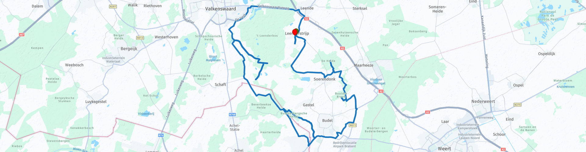
Baronie Cranendonck Noord Brabant

This route was brought to you by:
RouteXpert Hans van de Ven (Mr.MRA)
Last edit: 21-09-2021
 Route Summary
  Share this route


Animation

Verdict


Duration
1h 53m

Mode of travel
Bicycle

Distance
31.36 km

Countries

 RouteXpert Review
 This cycle route is signed in the "OpenStreetMap" map and can be used in navigation systems and / or can be printed with directions, via "Save as" and then choose .pdf.
Along the way you come by, or cycle through:
The Soerendonk Goor
In the water-rich area Het Soerendonkse Goor you can observe the many water birds that the area is rich from the bird observation hut. The Soerendonkse Goor is also fascinating from a botanical point of view, and on the peat and peat pits grow gale, willows and birch with in-between cattail, reed and Russians. Icelandic ponies graze in a fenced part of the swamp area - the Langbos. These ponies are dependent on what nature has to offer here for their daily cost and keep the landscape open. Nowadays also in other nature areas the natural management with this so-called winter hardy takes place. But these ponies have been staying here in Langbos for more than 30 years: management was a renewal at the time. In the future, selective logging will also focus on making the sharp transition between forest and open area more gradual. The heath frog also lives on the heath and on the transitions from higher to lower terrain sections the dorsal stripe and garlic toad are characteristic amphibians.
Cranendonk forest
Close to the hamlet of Cranendonck is the Cranendonck forest. It is a remnant of the once impenetrable swamp forest that has been located here in prehistoric times.
Budel
Budel is a former agricultural village that has grown out of its seams. It has grown up because of the accommodation of many employees of the southern zinc factory.
Dead wire
At junction 216 you will come across the border with Belgium. At the time of the First World War, the Germans installed a modern and frightening border barrier here: the Wire of Death. A reconstruction of the Dead Wire was made at the old border post 174. An information panel tells in detail about this barrier, equipped with six wires, intended to stop Belgians fleeing from the German occupiers.
Grenspaal 174, incidentally, dates from 1843. Then, as part of the Secession of the Netherlands, the brand new border was marked with 400 of these posts.
Great Heather
Extractions have made the Groote Heide small. From the 19th century, large parts of the heath have been transformed into coarse pine forests or into agricultural land. The remaining nature areas now consist of heather, overgrown drifting sand and fens. The heath is grazed by Kempen heath sheep. Because of the great variation in this area, various birds breed, including buzzard, wasp thief, nightjar, hatchery and various water birds such as the stilt walker.
Leenderstrijp
Leenderstrijp is an old agricultural hamlet with many original buildings. The triangular grass square still breathes the atmosphere of the past.
To the west of the village (approx. 500 m) you can see the St. John's Chapel from 1843 on a hill between old lime and oak trees.


 Links
Links  Usage
Usage Want to download this route?
You can download the route for free without MyRoute-app account. To do so, open the route and click 'save as'. Want to edit this route?
No problem, start by opening the route. Follow the tutorial and create your personal MyRoute-app account. After registration, your trial starts automatically.  Disclaimer
Use of this GPS route is at your own expense and risk. The route has been carefully composed and checked by a MyRoute-app accredited RouteXpert for use on TomTom, Garmin and MyRoute-app Navigation.
Changes may nevertheless have occurred due to changed circumstances, road diversions or seasonal closures. We therefore recommend checking each route before use.
Preferably use the route track in your navigation system. More information about the use of MyRoute-app can be found on the website under 'Community' or 'Academy'.