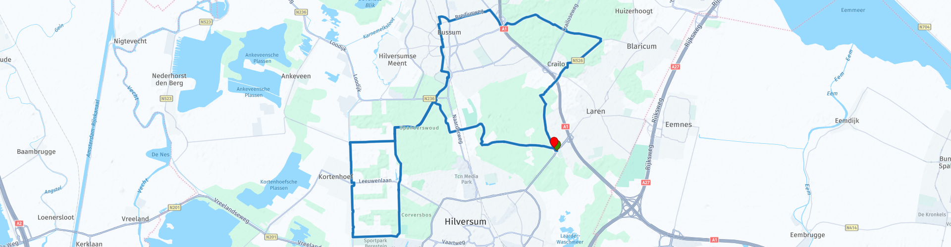
Gooise Heide Hilversum Noord Holland

This route was brought to you by:
RouteXpert Hans van de Ven (Mr.MRA)
Last edit: 11-10-2019
 Route Summary
  Share this route


Animation

Verdict


Duration
1h 50m

Mode of travel
Bicycle

Distance
30.51 km

Countries

 RouteXpert Review
 This cycle route is signed in the "OpenStreetMap" map and can be used in navigation systems and / or can be printed with directions, via "Save as" and then choose .pdf.
Along the way you come by, or you cycle through:
St. Janskerkhof
The St. Janskerkhof is the oldest inhabited place in the Gooi. Wide sandy paths, so-called 'dead roads', ran from all corners of the earth to the cemetery.
Westerheide
The slightly undulating Westerheide is very varied. Heather grows, but also broom, birch, oak and currant trees. If you look closely, you will see where the heath has been fenced. The combination of grazing and scaling (tapering, mowing or burning down) is a success: the grass has been prevented.
Burial mounds
The Westerheide is of great archaeological value with its fourteen burial mounds and an urn field that is one of the largest in Europe. Beyond the forest area there is a view of this grass-covered, approximately 5000-year-old burial mounds. Travelers used them as landmarks on the open heath.
Ecoduct
The Zanderij Crailoo Nature Bridge (ecoduct) is an ecological connection between the Gooise heathlands and the Vechtplassen area. Roe deer, earth mice, badgers, ring snakes, sand lizards and many other animals can expand their habitat thanks to the ecoduct. Plants also benefit from it, because they spread through the fur and droppings of animals, among other things. The unique project can be viewed from a lookout tower (information card). The Information Bridge Nature Bridge Zanderij is open on the 2nd and 4th Sunday of the month.
The Spanderswoud
Nature can take its course in the Spanderswoud. Fallen trees remain lying, young trees spontaneously shot up take their chance. About 100 to 150 years ago, the Spanderswoud was still part of the Gooise heathlands.
's-Graveland
Amsterdam merchants were allowed to dig a rectangular plot in 's-Graveland in the 17th century. The sand was taken to Amsterdam to dampen the swampy canals. Farms were built on the sand dunes, which grew into country estates in a park-like setting. The Natuurmonumenten visitor center shows everything about nature and landscape on the country estates. On the P a walk starts over Schaep and Burgh, Boekesteijn and Bantam.
Sheep and Scottish highlanders
If you do nothing, heather fields will close quickly. That is why sheep graze on the Blaricummer and Tafelberg heath (sheepfold open around 2 pm - 4 pm). Scottish highlanders have also been deported, who work more roughly. The grazing provides more variation in the vegetation. At Restaurant De Tafelberg the highest point of the Gooi is: Table Mountain (stairs to viewpoint at 36.4 m). For about 200 years there was almost no forest and Table Mountain offered an unobstructed view of the endless heathlands.
Laarder Eng
The fields along the Tafelbergweg and the Oude Drift are remnants of the Laarder Eng. They are managed by a foundation that grows old agricultural crops such as oats, rye and buckwheat. The name 'Oude Drift' refers to the sheep that were driven via this path from the sheepfold in the village to the heath.


 Links
Links  Usage
Usage Want to download this route?
You can download the route for free without MyRoute-app account. To do so, open the route and click 'save as'. Want to edit this route?
No problem, start by opening the route. Follow the tutorial and create your personal MyRoute-app account. After registration, your trial starts automatically.  Disclaimer
Use of this GPS route is at your own expense and risk. The route has been carefully composed and checked by a MyRoute-app accredited RouteXpert for use on TomTom, Garmin and MyRoute-app Navigation.
Changes may nevertheless have occurred due to changed circumstances, road diversions or seasonal closures. We therefore recommend checking each route before use.
Preferably use the route track in your navigation system. More information about the use of MyRoute-app can be found on the website under 'Community' or 'Academy'.