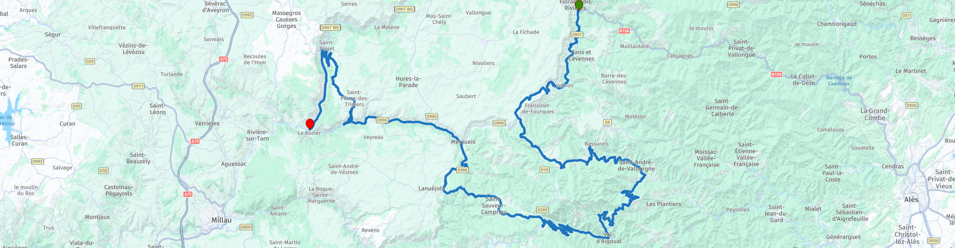
MTG2 21 FLorac Causse Mejean Le Rozier

This route was brought to you by:
RouteXpert René Plücken (MRA Master)
Last edit: 23-09-2025
 Route Summary
 This route comes from the French Motorcycle Tour Guide Part 2 and the original name is "Tarn and the Cévennes; Route description 2: around the Causse Méjean".
In the French Motorcycle Tour Guide, Part 2, a distinction is made between approach routes and tours within a specific area. The approach routes can also be used in conjunction with the routes from the French Motorcycle Tour Guide, Part 1.
The routes have sometimes been slightly modified based on tips Bert Loorbach provides in his description, or because of a different overnight stay, or to meet the minimum 2-hour time limit for the MRA Library. Each route review includes a more detailed description, including overnight options and points of interest along the way, which are also indicated with a point of interest and, if possible, a short description.
This route, with its beautiful winding roads (sometimes very narrow) through stunning scenery, deserves a 5-star rating. It's pure enjoyment, and there are several places to stop and enjoy all the beauty this region has to offer.
 Share this route


Animation

Verdict


Duration
6h 15m

Mode of travel
Car or motorcycle

Distance
168.06 km

Countries

 RouteXpert Review
 Now it's the turn of the regions to the south: the Cévennes (east) and the Tarn (west). Characteristic of much of this region are the "causses," expansive and barren plateaus with deep gorges. The Cévennes differ in their granite and slate subsoil. The ravines are somewhat less steep, and the landscape is less rugged. A trip from east to west, or vice versa, is incredibly scenic, giving you a good impression of this diverse region.
This is the description of the second of three routes in Tarn and Cévennes from the Motorcycle Touring Guide France part 2.
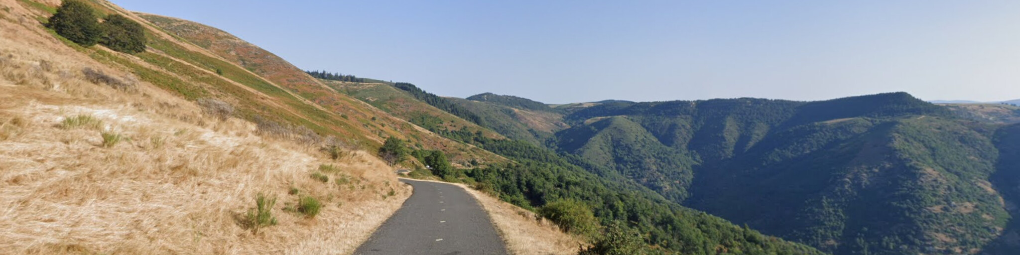
We start in Florac and take the D907/D996 to the tiny village of Vebron. Here, be sure to take the small road on the right, which will take you up to the plateau in a few loops. Be aware that some sections here are unpaved.
You now arrive at the Causses (meaning limestone plateau), and the Méjean is the summit of four of these plateaus: Sauveterre, Méjean, Noir, and Larzac. These are separated by deep river gorges. The extremely harsh climate has forced most people to flee, and the area has become the domain of animals.
Why would you take this impossible little road when you could also take the D-road through the Tarnon and Fraissinnet valleys? Because this road takes you to the Chaos de Nimes-le-Vieux (RP4). This is a rocky outcrop that, from a distance, resembles the ruins of a city—a beautiful spot. You'll have to walk a bit to get there, though. You can park your motorcycle in Veygalier or I'Hom.
Then you drive back down the plateau and back to the Col du Perjuret, from where the original route from Cabrillac takes you via the D18 to Mont Aigoual. This 1,567-meter-high peak serves as a weather station. On a clear day, you have a beautiful view, from the Alps to the Mediterranean Sea and the Pyrenees. There's also an exhibition by the French Meteorological Institute and a botanical forest called "I'Hort de Dieu" (the Garden of God).
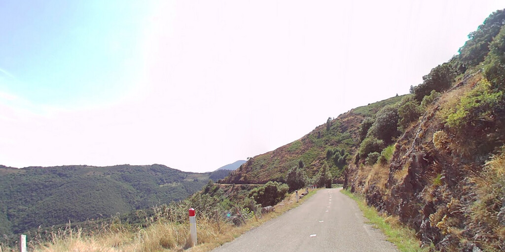
We turn left at Cabrillac and ride via the Col Salidès, where you have a beautiful view at over 1000 meters altitude, towards Saint-André-de-Valborgne. We continue via the beautiful, winding Col de l'Espinas and Col du Pas passes to Valleraugue. Here we cross the Hérault River, which we continue following on the very winding D986, so we enjoy some wonderful driving. Then we take the Col de la Serreyrède.
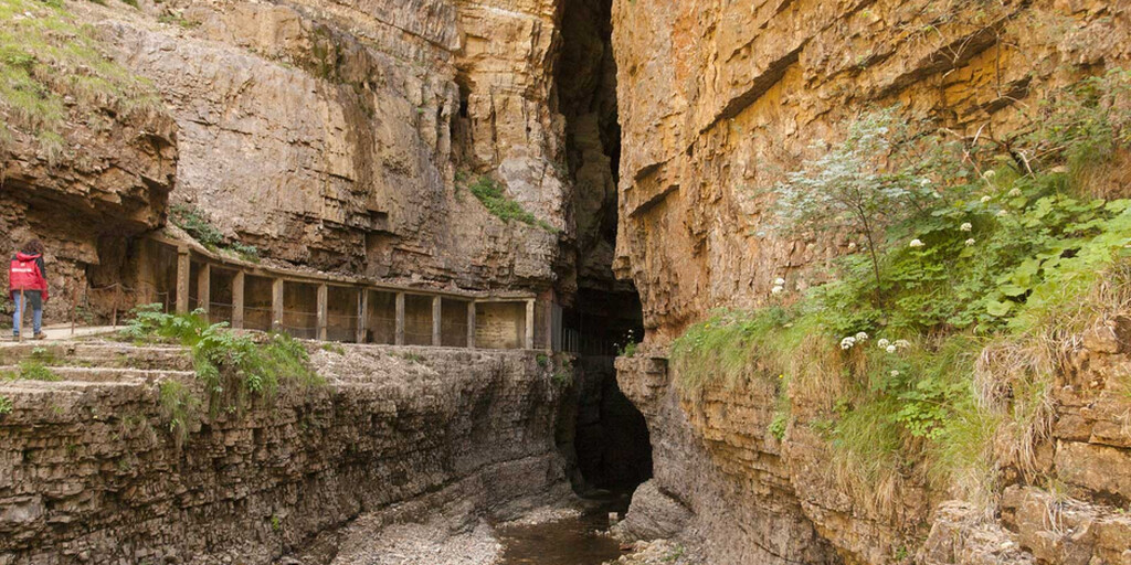
We visit Abîme de Bramabiau, a cave carved out by water that ultimately finds its way out through a waterfall. The river runs throughout the cave, and because almost no water seeps through the ceiling, there are almost no stalagmites or tuffs. This gives the cave a very different appearance than you're used to.
We then continue to Meyrueis, where we rejoin the original route and stop for lunch. No fewer than three rivers converge in Meyrueis: the Brèze, the Bétuzon, and the Jonte. Meyrueis is also the gateway to the Jonte Gorges, and we continue our journey through them (D996). These gorges aren't nearly as well-known as those of the Tarn, but they certainly have nothing to be ashamed of. As a natural cleft between the Causse Méjean and the Causse Noir, it guarantees a fantastic drive. Plus, it'll teach you a lesson about erosion! With a bit of luck, you'll have the best chance of spotting one of the giant vultures that have been released here. These animals have an impressive wingspan, which can reach up to 2 meters!
After over 20 kilometers of pure motorcycling enjoyment, the finish line, Le Rozier, comes into view. You could choose to continue and end the day, but if you're still in the mood for a bit of excitement and to see more of the Causse Méjean, here's what you should do: 5 km before Le Rozier lies tiny Le Truel. There you can turn right and ride almost vertically uphill to St. Pierre-des-Tripiers, after which you descend almost bobsledding-like to Les Vignes, where you take the D907 along the Tarn to the finish line, Le Rozier.
You can also make a round trip by turning right at the T-junction just after Le Bruel and taking the D16 to Florac.
 Links
Links  Usage
Usage Want to download this route?
You can download the route for free without MyRoute-app account. To do so, open the route and click 'save as'. Want to edit this route?
No problem, start by opening the route. Follow the tutorial and create your personal MyRoute-app account. After registration, your trial starts automatically.  Disclaimer
Use of this GPS route is at your own expense and risk. The route has been carefully composed and checked by a MyRoute-app accredited RouteXpert for use on TomTom, Garmin and MyRoute-app Navigation.
Changes may nevertheless have occurred due to changed circumstances, road diversions or seasonal closures. We therefore recommend checking each route before use.
Preferably use the route track in your navigation system. More information about the use of MyRoute-app can be found on the website under 'Community' or 'Academy'.

Occitanie
About this region
Occitanie (French pronunciation: [ɔksitani] (listen); Occitan: Occitània [utsiˈtanjɔ]; Catalan: Occitània [uksiˈtaniə]), Occitany or Occitania (), is the southernmost administrative region of metropolitan France excluding Corsica, created on 1 January 2016 from the former regions of Languedoc-Roussillon and Midi-Pyrénées. The Council of State approved Occitanie as the new name of the region on 28 September 2016, coming into effect on 30 September 2016.The modern administrative region is named after the larger cultural and historical region of Occitania, which corresponds with the southern third of France. The region Occitanie as it is today covers a territory similar to that ruled by the Counts of Toulouse in the 12th and 13th centuries. The banner of arms of the Counts of Toulouse, known colloquially as the Occitan cross, is used by the modern region and is also a popular cultural symbol. In 2015, Occitanie had a population of 5,839,867.
Read more on Wikipedia
View region
 Statistics
  83
83Amount of RX reviews (Occitanie)
 32362
32362Amount of visitors (Occitanie)
 4424
4424Amount of downloads (Occitanie)
 Route Collections in this region
 25 Magnificent trails in France
This MRA route collection contains 25 beautiful motorcycle routes in different parts of France, such as the Ardennes, the Alsace, Vercors, the Drôme, the Ardèche, Cote d'Azure, Gorges du Verdon, the Ariège, the Dordogne and Brittany.
The routes have been carefully created by Bert Loorbach, who is an enthusiastic motorcyclist himself. He lived in France for a year and a half, during which time he devoted himself to mapping the unknown and beautiful back roads of France especially for motorcyclists.
The routes are bundled in the Motortourgids France part 1 of Kosmos publishing house and now also available in MyRouteApp.
I have taken over the routes in MRA and sometimes adjusted them slightly to make them even more interesting for the motorcyclist.
View Route Collection
24 Magnificent trails in France
It is clear that France is one of the most beautiful and best touring countries. It offers an incredibly varied landscape with good roads and a pleasant climate. It is not for nothing that you see so many motorcyclists there. My previous collection of 25 routes in France (25 Magnificent routes in France) were based on the route descriptions from the Motortourgids France part 1 made by Bert Loorbach.
This collection of 24 routes comes from Motortourgids France part 2. In this collection, a difference has been made between approach routes and motorcycle tours in a certain area. The approach routes can also be used in combination with the routes from Motortourgids France part 1
The routes are sometimes slightly adjusted based on the tips that Bert Loorbach gives in his description, or because of another place to spend the night, or to reach the minimum length of 2 hours for the MRA Library. For each route, the review contains a more detailed description, including options to stay overnight or places of interest along the way, which are also indicated with a POI and if possible with a short description.
Two or more routes have been created for a number of areas, such as for Burgundy, Auvergne, The Alps, Tarn and Cévennes and Nord-Pas de Calais. These routes can be nicely combined in a multi-day trip.
View Route Collection