Day 18 TCH Sault Ste Marie to Espanola

This route was brought to you by:
RouteXpert René Plücken (MRA Master)
Last edit: 10-11-2025
 Route Summary
 This is section 18 that runs from Sault Ste Marie to Espanola.
The Trans-Canada Highway passes through all of the country's southern provinces. The route can be driven in various ways, as there are several alternative routes that also belong to the Trans-Canada Highway. The total distance is around 8,000 km. We won't be driving solely the Trans-Canada Highway, but will be taking as much of the country's back roads as possible, as highway driving alone is too boring, and Canada boasts many beautiful roads through its stunning landscape.
You'll drive through all the provinces and through very diverse and picturesque landscapes, from the Rockies in the west, the Central Prairies to the eastern Maritimes and the northern forest.
The riding season is generally from April to October with longer seasons on the west coast and southern Ontario.
Make sure you have good all-season clothing or bring rain gear. Depending on the province and the season, the weather can change suddenly and you might be surprised by a rain shower, or even a snow or hail shower, so be prepared.
In Canada, the metric system is used, so speeds are indicated in km/h. Helmets are mandatory throughout Canada (DOT approved).
Throughout Canada, you'll see plenty of wildlife. Similar animals vary from province to province, including deer, buffalo, moose, caribou, wolves, cougars, bears, mountain goats, sheep, lynx, coyotes, foxes, raccoons, badgers, various rodents, and a variety of birds.
Even though it is very tempting to stop for a photo, don't do it, it can be very dangerous.
I rate this route 5***** stars for its beautiful roads, scenery, waterfalls, and several interesting museums. For hikers, there are also several trailheads along the route; these are clearly marked but not included in this review.
 Share this route


Animation

Verdict


Duration
7h 7m

Mode of travel
Car or motorcycle

Distance
256.32 km

Countries


 RouteXpert Review
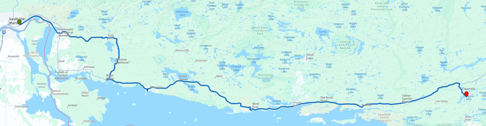
 After a few days along Lake Superior, we're heading further inland today. The drive from Sault Ste. Marie to Espanola is a mix of quiet provincial roads and stretches of Trans-Canada Highway, sometimes four-lane and straight, sometimes narrow and winding through forests and along rivers. A stretch full of little surprises and beautiful panoramas.
We avoid the boring first section of the TCH and choose Highway 17B, which runs parallel to the railway line, until Echo Bay. With a bit of luck, you'll see one of those iconic Canadian freight trains thundering past—a magnificent sight. Then we follow Highway 638, a two-lane road that winds through a green landscape, past forests and meadows.
Our stops along the way:
• Loon Dollar Monument (Echo Bay)
An impressive monument honoring Robert R. Carmichael, the artist behind the design of the Canadian "Loonie" coin. A fun photo stop and a taste of Canadian culture.
• Thessalon River Bridge
A narrow steel bridge with a metal deck—be careful in the rain! On the other side, we stopped for a photo of the bridge and the dam in the river. A spot that perfectly captures the charm of Northern Ontario.
• Bruce Mines Museum
Housed in a former church dating back to 1894, this museum tells the story of the region's mining history. Small but authentic, it's a must-see for anyone interested in local history.
• Sinton Tavern (Thessalon)
A pleasant spot for a quick refreshment break before continuing towards Iron Bridge. From here, the TCH meanders along the Mississagi River, offering beautiful views at regular intervals.
• Picnic Stop at Woman Island
A small parking lot with picnic tables and views of the river and island. Perfect for a short break.
• Mississagi Falls
A photogenic rapid in the river, surrounded by rocks with a warm red glow. One of those places where you just want to pause for a moment.
• Blind River
Here we'll visit the Timber Village Museum, a charming museum with art, history, and a gift shop stocked with local products. Afterward, we'll have lunch at one of the restaurants along the TCH, with plenty of choices for a hearty meal.
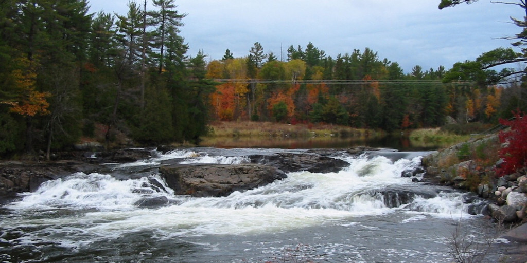
• Kennebec Falls (Serpent River)
Another waterfall, this time in the Serpent River. From the bridge, you can see the water cascading down, but if you take the path down, you'll get an even more stunning view.
After this last stop, it's another 70 kilometers of enjoying forests, rivers, and quiet roads until we arrive in Espanola, where we spend the night at the Lake Apsey Resort.
My rating: ★★★★★, Five stars for a varied section: from historical museums to photogenic waterfalls and quiet country roads. For hikers, there are several clearly marked trailheads along the route, so those with time can explore even more.

 Links
Links  Usage
Usage Want to download this route?
You can download the route for free without MyRoute-app account. To do so, open the route and click 'save as'. Want to edit this route?
No problem, start by opening the route. Follow the tutorial and create your personal MyRoute-app account. After registration, your trial starts automatically.  Disclaimer
Use of this GPS route is at your own expense and risk. The route has been carefully composed and checked by a MyRoute-app accredited RouteXpert for use on TomTom, Garmin and MyRoute-app Navigation.
Changes may nevertheless have occurred due to changed circumstances, road diversions or seasonal closures. We therefore recommend checking each route before use.
Preferably use the route track in your navigation system. More information about the use of MyRoute-app can be found on the website under 'Community' or 'Academy'.
Michigan
About this region
Michigan is a state in the Great Lakes region of the upper Midwestern United States. Its name derives from a gallicized variant of the original Ojibwe word ᒥᓯᑲᒥ (mishigami), meaning 'large water' or 'large lake'. With a population of nearly 10.1 million and a total area of nearly 97,000 sq mi (250,000 km2), Michigan is the 10th-largest state by population, the 11th-largest by area, and the largest east of the Mississippi River. Its capital is Lansing, and its largest city is Detroit. Metro Detroit is among the nation's most populous and largest metropolitan economies.
Michigan is the only state to consist of two peninsulas. The Lower Peninsula is shaped like a mitten. The Upper Peninsula (often called "the U.P.") is separated from the Lower Peninsula by the Straits of Mackinac, a five-mile (8 km) channel that joins Lake Huron to Lake Michigan. The Mackinac Bridge connects the peninsulas. Michigan has the longest freshwater coastline of any political subdivision in the world, being bordered by four of the five Great Lakes, plus Lake St. Clair. It also has 64,980 inland lakes and ponds.The area was first occupied by a succession of Native American tribes over thousands of years. Inhabited by natives, Métis, and French explorers in the 17th century, it was claimed as part of the New France colony. After France's defeat in the French and Indian War in 1762, the region came under British rule. Britain ceded the territory to the newly independent United States after Britain's defeat in the American Revolutionary War. The area was part of the larger Northwest Territory until 1800, when western Michigan became part of the Indiana Territory. Michigan Territory was formed in 1805, but some of the northern border with Canada was not agreed upon until after the War of 1812. Michigan was admitted into the Union in 1837 as the 26th state, a free one. It soon became an important center of industry and trade in the Great Lakes region and a popular émigré destination in the late 19th and early 20th centuries; immigration from many European countries to Michigan was also the busiest at that time, especially for those who emigrated from Finland, Macedonia and the Netherlands.Although Michigan developed a diverse economy, it is widely known as the center of the U.S. automotive industry, which developed as a major economic force in the early 20th century. It is home to the country's three major automobile companies (whose headquarters are all in Metro Detroit). While sparsely populated, the Upper Peninsula is important for tourism due to its abundance of natural resources, while the Lower Peninsula is a center of manufacturing, forestry, agriculture, services, and high-tech industry.
Read more on Wikipedia
Michigan is the only state to consist of two peninsulas. The Lower Peninsula is shaped like a mitten. The Upper Peninsula (often called "the U.P.") is separated from the Lower Peninsula by the Straits of Mackinac, a five-mile (8 km) channel that joins Lake Huron to Lake Michigan. The Mackinac Bridge connects the peninsulas. Michigan has the longest freshwater coastline of any political subdivision in the world, being bordered by four of the five Great Lakes, plus Lake St. Clair. It also has 64,980 inland lakes and ponds.The area was first occupied by a succession of Native American tribes over thousands of years. Inhabited by natives, Métis, and French explorers in the 17th century, it was claimed as part of the New France colony. After France's defeat in the French and Indian War in 1762, the region came under British rule. Britain ceded the territory to the newly independent United States after Britain's defeat in the American Revolutionary War. The area was part of the larger Northwest Territory until 1800, when western Michigan became part of the Indiana Territory. Michigan Territory was formed in 1805, but some of the northern border with Canada was not agreed upon until after the War of 1812. Michigan was admitted into the Union in 1837 as the 26th state, a free one. It soon became an important center of industry and trade in the Great Lakes region and a popular émigré destination in the late 19th and early 20th centuries; immigration from many European countries to Michigan was also the busiest at that time, especially for those who emigrated from Finland, Macedonia and the Netherlands.Although Michigan developed a diverse economy, it is widely known as the center of the U.S. automotive industry, which developed as a major economic force in the early 20th century. It is home to the country's three major automobile companies (whose headquarters are all in Metro Detroit). While sparsely populated, the Upper Peninsula is important for tourism due to its abundance of natural resources, while the Lower Peninsula is a center of manufacturing, forestry, agriculture, services, and high-tech industry.
View region
 Statistics
  9
9Amount of RX reviews (Michigan)
 16352
16352Amount of visitors (Michigan)
 167
167Amount of downloads (Michigan)
 Route Collections in this region
 The ultimate Great Lakes Tour
This is a tour from Chicago to Staten Island, New York visiting the 5 Great Lakes of North America.
Starting from EagleRider Motorcycle rental at Illinois Harley-Davidson in Chicago and ending at EagleRider Motorcycle rental in Staten Island.
The Ultimate Great Lakes tour is a route through the United States and Canada to scenic destinations along Lakes Michigan, Superior, Huron, Erie and Ontario.
What are the Great Lakes? The Great Lakes are a series of five interconnected freshwater lakes located on the border of the United States and Canada. They are the largest group of freshwater lakes in the world by area and have sea-like characteristics such as rolling waves, strong currents, miles of sandy and rocky beaches, and distant horizons. This tour of 8 routes includes places to stop for coffee, lunch and overnight hotels. It also visits well known historic and scenic sites along the way mostly avoiding major highways. I have suggested 2 nights at Lake Superior and 2 nights at Niagara Falls, making this a 10 day tour, but of course, that is up to you. The scenery and landscapes are breathtaking and each day is different to the next. Please enjoy.
View Route Collection
Trans Canada Highway
The Trans-Canada Highway (TCH) or Trans-Canadian Highway is a system of highways that cover all 10 provinces of Canada.
The Federal and Provincial Highways System that now forms the TCH were authorized by the Trans-Canada Highway Act of 1948 and opened in 1962. It was completed in 1971. The total length of the TCH is 7821 km.
Contrary to the American Interstate Highway System, the TCH does not consist of an unambiguous network of motorways, but forms a network of restricted access highways and other main routes that are more akin to the Dutch provincial roads. The route is indicated by a green shield with a white maple leaf.
The numbering of the roads that are part of the TCH is the domain of the provinces. Only the western provinces have aligned their numbering and the TCH has the designation Highway 1 there.
The main route of the TCH starts in Victoria in British Columbia and runs via Calgary and Regina to Winnipeg. From Winnipeg the route leads to Kenora in Ontario, after which several branches pass through Ontario to Ottawa.
Further east, the route passes through the province of Quebec via Montreal and Quebec, among others, to Moncton, New Brunswick. Then the TCH continues east through Nova Scotia, where a branch (via the Confederation Bridge) leads to Prince Edward Island. Another section runs down to the sea in the port city of Sydney, where a ferry service leaves for Channel-Port aux Basques on the island of Newfoundland. From there the route continues for more than 900 km to the provincial capital of St. John's, in the extreme southeast of the island.
We not only drive the TCH, but will take the rural roads as much as possible, because only Highway driving is too boring and Canada has many beautiful roads through its beautiful landscape. You drive through all provinces and through very varied and scenic landscapes, from the Rockies in the West, the Central Prairies to the Eastern Maritimes and the Northern Forest.
The riding season is generally April through October with longer seasons on the west coast and southern Ontario. Provide good all season clothing or bring rain gear, depending on the province and the season the weather can change and you may be surprised by a rain or even a snow or hail shower, so be prepared.
In Canada the metric system is used, so speeds are indicated in Km / h. A helmet requirement (DOT approved) applies throughout Canada.
You will see many wildlife throughout Canada. This varies from province to province, such as deer, buffalos, moose, caribou, wolves, pumas, bears, mountain goats, sheep, lynx, coyotes, foxes, raccoons, badgers, various rodents and all kinds of birds. Even if it is very tempting to stop for a photo, don't do it, it can be very dangerous.
The routes described in this review sometimes deviate from the Trans Canada Highway, bringing the total length to 9,300 kilometers. The routes are made so that you drive through the beautiful parts of Canada with truly beautiful panoramas and beautiful sights to visit, this differs from museums, parks to historical points. The routes are not too long so there is time to stop for photos and sights along the way. You can also choose to arrange and combine the stages differently or to add other routes to shorten or extend your journey. The routes are marked with a rating in stars, some routes are less challenging or interesting but are necessary to drive to the next point, which is why they often have a lower rating.
In the route description you will find more details about the routes and the points of interest along the way. These points and also hotels, restaurants, petrol stations etc. are indicated with a POI and sometimes also with a Route point. In the description you will also find links to interesting sites and to the routes that connect to that day.
The described routes are;
Day 01 TCH Victory to Nanaimo
Day 02 TCH Nanaimo to Hope
Day 03 TCH Hope to Kamloops
Day 04 TCH Kamloops to Revelstoke
Day 05 TCH Revelstoke to Lake Louise
Day 06 TCH Lake Louise to Calgary
Day 07 TCH Calgary to Medicine Hat
Day 08 TCH Medicine Hat to Moose Jaw
Day 09 TCH Moose Jaw to Regina
Day 10 TCH Regina to Brandon
Day 11 TCH Brandon to Winnipeg
Day 12 TCH Winnipeg to Kenora
Day 13 TCH Kenora to Ignace
Day 14 TCH Ignace to Thunder Bay
Day 15 TCH Thunder Bay to Marathon
Day 16 Thunder Bay to Wawa
Day 17 TCH Wawa to Sault Ste Marie
Day 18 TCH Sault Ste Marie to Espanola
Day 19 TCH Espanola to Mattawa
Day 20 TCH Mattawa to Ottawa
Day 21 TCH Ottawa to Montreal
Day 22 TCH Montreal to Quebec
Day 23 TCH Quebec to Riviere du Loup
Day 24 TCH Riviere du Loup to Grand Falls
Day 25 TCH Grand Falls to Fredericton
Day 26 TCH Fredericton to Moncton
Day 27 TCH Moncton to Charlottetown
Day 28 TCH Charlottetown to Truro
Day 29 TCH Truro to North Sydney
Day 30 TCH North Sydney to Corner Brook
Day 31 TCH Corner Brook to Grand Falls
Day 32 TCH Grand Falls to Clarenville
Day 33 TCH Clarenville to St John.
Have fun reading the reviews and planning your next road trip.
If you have driven this trip, I am very curious about your feedback!
View Route Collection