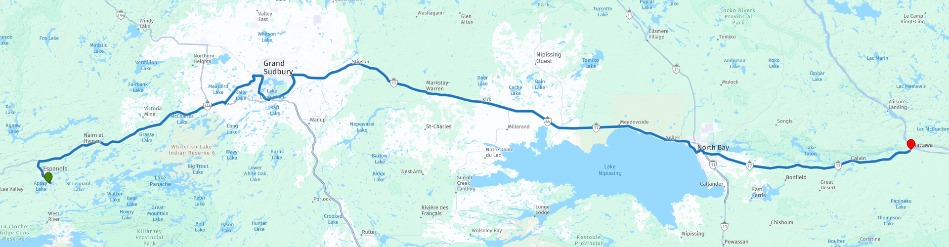
Day 19 TCH Espanola to Mattawa

This route was brought to you by:
RouteXpert René Plücken (MRA Master)
Last edit: 11-11-2025
 Route Summary
 This is section 19 which runs from Espanola to Mattawa.
The Trans-Canada Highway passes through all of the country's southern provinces. The route can be driven in various ways, as there are several alternative routes that also belong to the Trans-Canada Highway. The total distance is around 8,000 km. We won't be driving solely the Trans-Canada Highway, but will be taking as much of the country's back roads as possible, as highway driving alone is too boring, and Canada boasts many beautiful roads through its stunning landscape.
You'll drive through all the provinces and through very diverse and picturesque landscapes, from the Rockies in the west, the Central Prairies to the eastern Maritimes and the northern forest.
The riding season is generally from April to October with longer seasons on the west coast and southern Ontario.
Make sure you have good all-season clothing or bring rain gear. Depending on the province and the season, the weather can change suddenly and you might be surprised by a rain shower, or even a snow or hail shower, so be prepared.
In Canada, the metric system is used, so speeds are indicated in km/h. Helmets are mandatory throughout Canada (DOT approved).
Throughout Canada, you'll see plenty of wildlife. Similar animals vary from province to province, including deer, buffalo, moose, caribou, wolves, cougars, bears, mountain goats, sheep, lynx, coyotes, foxes, raccoons, badgers, various rodents, and a variety of birds.
Even though it is very tempting to stop for a photo, don't do it, it can be very dangerous.
I rate this ride with 4**** stars, these roads are good but not spectacular, you do have beautiful panoramas and nature along the way and there are a few museums you can visit
 Share this route


Animation

Verdict


Duration
6h 53m

Mode of travel
Car or motorcycle

Distance
280.17 km

Countries

 RouteXpert Review
 Today we're riding a long 280-kilometer stretch, largely on the Trans-Canada Highway. No provincial detours this time, but a route that takes us through the heart of Southern Ontario, past rivers, railway lines, and two interesting cities: Sudbury and North Bay.
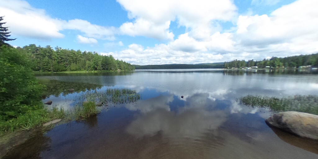
The first part is straight and wide, but we make it fun by planning a few stops along the way.
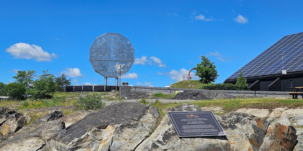
Sudbury, City of Nickel and Science
Our first long stop is Sudbury, the largest city in Northern Ontario, with over 164,000 inhabitants. Sudbury sits on the rim of the Sudbury Basin, the second-largest impact crater on Earth. Its mining history is still visible in the 380-meter-high Inco Superstack, an impressive silhouette against the sky. You can visit several museums here;
• Dynamic Earth Science Museum
An interactive museum that brings Sudbury's mining history to life. It also houses the famous Big Nickel, a giant coin that symbolizes the city.
• Science North Museum
Northern Ontario's crowd-pleaser. With a planetarium, IMAX, theatre, live animals, and interactive exhibits, this is a place where science becomes fun.
After Sudbury, we'll drive past the Lake Laurentian Conservation Area and follow the railway line and the North Veuve River. With a bit of luck, you'll see an impressive Canadian Pacific Railway freight train rumble by.
Halfway through, we'll have lunch at Kate's Kountry Kitchen, a truck stop and bakery where home-cooked meals and pies await. Don't forget a jar of jam or garlic spread!
We continue our journey along Lake Nipissing to North Bay, where we stop at the North Bay Museum, housed in a historic Canadian Pacific Railway station. The museum tells the story of North Bay through interactive exhibits and artifacts, a wonderful blend of culture and history.
The last 60 kilometers to Mattawa are straightforward, but if you're traveling with a group and still have energy, you can make an extra stop at Pyramid Paintball Center for a dose of action.
My rating: ★★★★, Four stars for a leg that focuses primarily on museums and culture, with beautiful panoramas and a touch of railway nostalgia along the way. No spectacular scenery today, but interesting stops and a comfortable ride.
 Links
Links  Usage
Usage Want to download this route?
You can download the route for free without MyRoute-app account. To do so, open the route and click 'save as'. Want to edit this route?
No problem, start by opening the route. Follow the tutorial and create your personal MyRoute-app account. After registration, your trial starts automatically.  Disclaimer
Use of this GPS route is at your own expense and risk. The route has been carefully composed and checked by a MyRoute-app accredited RouteXpert for use on TomTom, Garmin and MyRoute-app Navigation.
Changes may nevertheless have occurred due to changed circumstances, road diversions or seasonal closures. We therefore recommend checking each route before use.
Preferably use the route track in your navigation system. More information about the use of MyRoute-app can be found on the website under 'Community' or 'Academy'.

Ontario
About this region
Ontario ( (listen) on-TAIR-ee-oh; French: [ɔ̃taʁjo]) is one of the thirteen provinces and territories of Canada. Located in Central Canada, it is Canada's most populous province, with 38.3 percent of the country's population, and is the second-largest province by total area (after Quebec). Ontario is Canada's fourth-largest jurisdiction in total area when the territories of the Northwest Territories and Nunavut are included. It is home to the nation's capital city, Ottawa, and the nation's most populous city, Toronto, which is also Ontario's provincial capital.
Ontario is bordered by the province of Manitoba to the west, Hudson Bay and James Bay to the north, and Quebec to the east and northeast, and to the south by the U.S. states of (from west to east) Minnesota, Michigan, Ohio, Pennsylvania, and New York. Almost all of Ontario's 2,700 km (1,678 mi) border with the United States follows inland waterways: from the westerly Lake of the Woods, eastward along the major rivers and lakes of the Great Lakes/Saint Lawrence River drainage system. These include Rainy River, Pigeon River, Lake Superior, St. Marys River, Lake Huron, St. Clair River, Lake St. Clair, Detroit River, Lake Erie, Niagara River, Lake Ontario and the St. Lawrence River from Kingston, to the Quebec boundary just east of Cornwall. There is only about 1 km (0.6 mi) of land border, made up of portages including Height of Land Portage on the Minnesota border.Ontario is sometimes conceptually divided into two regions, Northern Ontario and Southern Ontario. The great majority of Ontario's population and arable land is in the south. In contrast, the larger, northern part of Ontario is sparsely populated with cold winters and heavy forestation.
Read more on Wikipedia
Ontario is bordered by the province of Manitoba to the west, Hudson Bay and James Bay to the north, and Quebec to the east and northeast, and to the south by the U.S. states of (from west to east) Minnesota, Michigan, Ohio, Pennsylvania, and New York. Almost all of Ontario's 2,700 km (1,678 mi) border with the United States follows inland waterways: from the westerly Lake of the Woods, eastward along the major rivers and lakes of the Great Lakes/Saint Lawrence River drainage system. These include Rainy River, Pigeon River, Lake Superior, St. Marys River, Lake Huron, St. Clair River, Lake St. Clair, Detroit River, Lake Erie, Niagara River, Lake Ontario and the St. Lawrence River from Kingston, to the Quebec boundary just east of Cornwall. There is only about 1 km (0.6 mi) of land border, made up of portages including Height of Land Portage on the Minnesota border.Ontario is sometimes conceptually divided into two regions, Northern Ontario and Southern Ontario. The great majority of Ontario's population and arable land is in the south. In contrast, the larger, northern part of Ontario is sparsely populated with cold winters and heavy forestation.
View region
 Statistics
  18
18Amount of RX reviews (Ontario)
 15710
15710Amount of visitors (Ontario)
 558
558Amount of downloads (Ontario)
 Route Collections in this region
 The ultimate Great Lakes Tour
This is a tour from Chicago to Staten Island, New York visiting the 5 Great Lakes of North America.
Starting from EagleRider Motorcycle rental at Illinois Harley-Davidson in Chicago and ending at EagleRider Motorcycle rental in Staten Island.
The Ultimate Great Lakes tour is a route through the United States and Canada to scenic destinations along Lakes Michigan, Superior, Huron, Erie and Ontario.
What are the Great Lakes? The Great Lakes are a series of five interconnected freshwater lakes located on the border of the United States and Canada. They are the largest group of freshwater lakes in the world by area and have sea-like characteristics such as rolling waves, strong currents, miles of sandy and rocky beaches, and distant horizons. This tour of 8 routes includes places to stop for coffee, lunch and overnight hotels. It also visits well known historic and scenic sites along the way mostly avoiding major highways. I have suggested 2 nights at Lake Superior and 2 nights at Niagara Falls, making this a 10 day tour, but of course, that is up to you. The scenery and landscapes are breathtaking and each day is different to the next. Please enjoy.
View Route Collection
Trans Canada Highway
The Trans-Canada Highway (TCH) or Trans-Canadian Highway is a system of highways that cover all 10 provinces of Canada.
The Federal and Provincial Highways System that now forms the TCH were authorized by the Trans-Canada Highway Act of 1948 and opened in 1962. It was completed in 1971. The total length of the TCH is 7821 km.
Contrary to the American Interstate Highway System, the TCH does not consist of an unambiguous network of motorways, but forms a network of restricted access highways and other main routes that are more akin to the Dutch provincial roads. The route is indicated by a green shield with a white maple leaf.
The numbering of the roads that are part of the TCH is the domain of the provinces. Only the western provinces have aligned their numbering and the TCH has the designation Highway 1 there.
The main route of the TCH starts in Victoria in British Columbia and runs via Calgary and Regina to Winnipeg. From Winnipeg the route leads to Kenora in Ontario, after which several branches pass through Ontario to Ottawa.
Further east, the route passes through the province of Quebec via Montreal and Quebec, among others, to Moncton, New Brunswick. Then the TCH continues east through Nova Scotia, where a branch (via the Confederation Bridge) leads to Prince Edward Island. Another section runs down to the sea in the port city of Sydney, where a ferry service leaves for Channel-Port aux Basques on the island of Newfoundland. From there the route continues for more than 900 km to the provincial capital of St. John's, in the extreme southeast of the island.
We not only drive the TCH, but will take the rural roads as much as possible, because only Highway driving is too boring and Canada has many beautiful roads through its beautiful landscape. You drive through all provinces and through very varied and scenic landscapes, from the Rockies in the West, the Central Prairies to the Eastern Maritimes and the Northern Forest.
The riding season is generally April through October with longer seasons on the west coast and southern Ontario. Provide good all season clothing or bring rain gear, depending on the province and the season the weather can change and you may be surprised by a rain or even a snow or hail shower, so be prepared.
In Canada the metric system is used, so speeds are indicated in Km / h. A helmet requirement (DOT approved) applies throughout Canada.
You will see many wildlife throughout Canada. This varies from province to province, such as deer, buffalos, moose, caribou, wolves, pumas, bears, mountain goats, sheep, lynx, coyotes, foxes, raccoons, badgers, various rodents and all kinds of birds. Even if it is very tempting to stop for a photo, don't do it, it can be very dangerous.
The routes described in this review sometimes deviate from the Trans Canada Highway, bringing the total length to 9,300 kilometers. The routes are made so that you drive through the beautiful parts of Canada with truly beautiful panoramas and beautiful sights to visit, this differs from museums, parks to historical points. The routes are not too long so there is time to stop for photos and sights along the way. You can also choose to arrange and combine the stages differently or to add other routes to shorten or extend your journey. The routes are marked with a rating in stars, some routes are less challenging or interesting but are necessary to drive to the next point, which is why they often have a lower rating.
In the route description you will find more details about the routes and the points of interest along the way. These points and also hotels, restaurants, petrol stations etc. are indicated with a POI and sometimes also with a Route point. In the description you will also find links to interesting sites and to the routes that connect to that day.
The described routes are;
Day 01 TCH Victory to Nanaimo
Day 02 TCH Nanaimo to Hope
Day 03 TCH Hope to Kamloops
Day 04 TCH Kamloops to Revelstoke
Day 05 TCH Revelstoke to Lake Louise
Day 06 TCH Lake Louise to Calgary
Day 07 TCH Calgary to Medicine Hat
Day 08 TCH Medicine Hat to Moose Jaw
Day 09 TCH Moose Jaw to Regina
Day 10 TCH Regina to Brandon
Day 11 TCH Brandon to Winnipeg
Day 12 TCH Winnipeg to Kenora
Day 13 TCH Kenora to Ignace
Day 14 TCH Ignace to Thunder Bay
Day 15 TCH Thunder Bay to Marathon
Day 16 Thunder Bay to Wawa
Day 17 TCH Wawa to Sault Ste Marie
Day 18 TCH Sault Ste Marie to Espanola
Day 19 TCH Espanola to Mattawa
Day 20 TCH Mattawa to Ottawa
Day 21 TCH Ottawa to Montreal
Day 22 TCH Montreal to Quebec
Day 23 TCH Quebec to Riviere du Loup
Day 24 TCH Riviere du Loup to Grand Falls
Day 25 TCH Grand Falls to Fredericton
Day 26 TCH Fredericton to Moncton
Day 27 TCH Moncton to Charlottetown
Day 28 TCH Charlottetown to Truro
Day 29 TCH Truro to North Sydney
Day 30 TCH North Sydney to Corner Brook
Day 31 TCH Corner Brook to Grand Falls
Day 32 TCH Grand Falls to Clarenville
Day 33 TCH Clarenville to St John.
Have fun reading the reviews and planning your next road trip.
If you have driven this trip, I am very curious about your feedback!
View Route Collection