Day 26 TCH Fredericton to Moncton

This route was brought to you by:
RouteXpert René Plücken (MRA Master)
Last edit: 16-11-2025
 Route Summary
 This is section 26 which runs from Fredericton to Moncton.
The Trans-Canada Highway passes through all of the country's southern provinces. The route can be driven in various ways, as there are several alternative routes that also belong to the Trans-Canada Highway. The total distance is around 8,000 km. We won't be driving solely the Trans-Canada Highway, but will be taking as much of the country's back roads as possible, as highway driving alone is too boring, and Canada boasts many beautiful roads through its stunning landscape.
You'll drive through all the provinces and through very diverse and picturesque landscapes, from the Rockies in the west, the Central Prairies to the eastern Maritimes and the northern forest.
The riding season is generally from April to October with longer seasons on the west coast and southern Ontario.
Make sure you have good all-season clothing or bring rain gear. Depending on the province and the season, the weather can change suddenly and you might be surprised by a rain shower, or even a snow or hail shower, so be prepared.
In Canada, the metric system is used, so speeds are indicated in km/h. Helmets are mandatory throughout Canada (DOT approved).
Throughout Canada, you'll see plenty of wildlife. Similar animals vary from province to province, including deer, buffalo, moose, caribou, wolves, cougars, bears, mountain goats, sheep, lynx, coyotes, foxes, raccoons, badgers, various rodents, and a variety of birds.
Even though it is very tempting to stop for a photo, don't do it, it can be very dangerous.
This route doesn't have any special stops, but the roads and the beautiful scenery make this a very nice ride that I rate with 4**** stars.
 Share this route


Animation

Verdict


Duration
5h 28m

Mode of travel
Car or motorcycle

Distance
282.90 km

Countries

 RouteXpert Review
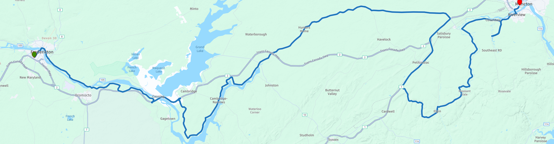
 The fastest route from Fredericton to Moncton is the new Trans Canada Highway (Highway 2), a four-lane highway that has shortened the distance by 30 km since 2003. But for motorcyclists, that's boring. We opt for the old route and winding roads along the Saint John River and through the green heart of New Brunswick. Therefore, today we have a scenic ride of approximately 285 km on the agenda.
We leave Fredericton on the north side and cross the Saint John River. Our first stop is Carleton Park, with views of the river and the Bill Thorpe Walking Bridge. This former railway bridge is now a pedestrian bridge and part of the Trans Canada Trail. Fredericton proudly calls it the "world's longest walking bridge."
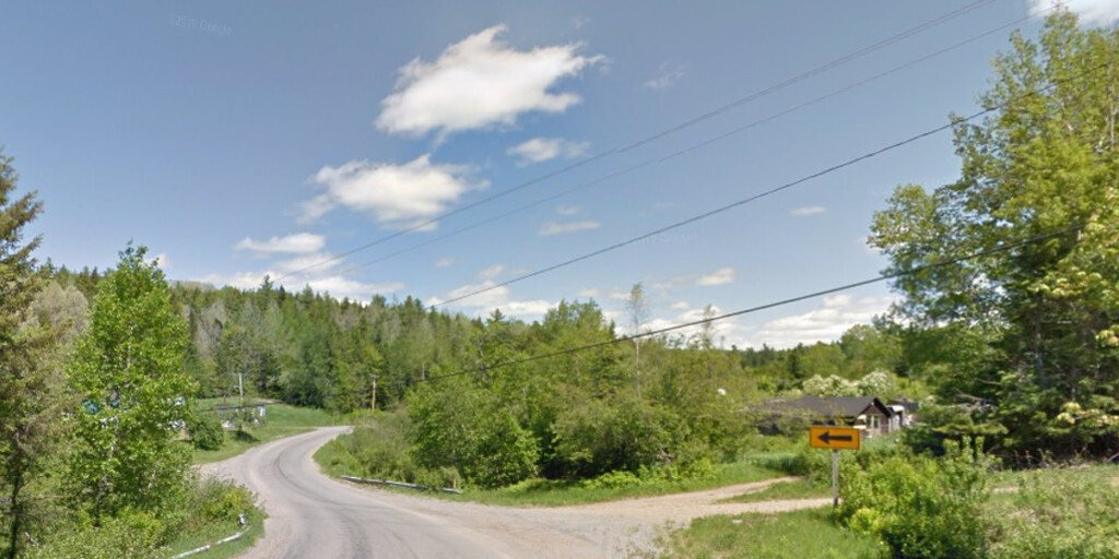
We take NB-105, which follows the course of the Saint John River through a landscape of forests, meadows, and small villages. Typical white Baptist churches and gentle curves make this a delightful route. Occasionally, you see the river peeking through the trees. Note: overtaking is prohibited in many sections.
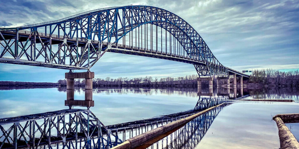
We cross the Saint John River via the Burton Bridge, a 765-meter-long steel arch bridge, opened in 1973. An impressive structure that once replaced a cable ferry.
We drive a short distance on the TCH to NB-715, a winding road through the green landscape. At Coles Island, it merges into NB-112. This is pure bliss: quiet roads, little traffic, and abundant nature.
Our lunch stop is at Salisbury Big Stop, a classic truck stop with home-cooked meals and gas. From there, you can choose:
• Option 1: Turn onto the TCH for the final 25 km to Moncton.
• Option 2: Stay on the old route via NB-895 and NB-910, through the beautiful hilly terrain south of Moncton.
Bilingual Moncton is the end point of this scenic drive and is one of the largest cities in the province of New Brunswick. The city is the heart of Acadia, a region primarily inhabited by Acadians (descendants of the first French colonists). Moncton is rapidly developing in recreational, cultural, and economic areas.
My rating: ★★★★. No major sights, but a charming drive thanks to the old roads, rolling curves, and green New Brunswick landscape. Perfect for avoiding the highway and enjoying the drive.
 Links
Links  Usage
Usage Want to download this route?
You can download the route for free without MyRoute-app account. To do so, open the route and click 'save as'. Want to edit this route?
No problem, start by opening the route. Follow the tutorial and create your personal MyRoute-app account. After registration, your trial starts automatically.  Disclaimer
Use of this GPS route is at your own expense and risk. The route has been carefully composed and checked by a MyRoute-app accredited RouteXpert for use on TomTom, Garmin and MyRoute-app Navigation.
Changes may nevertheless have occurred due to changed circumstances, road diversions or seasonal closures. We therefore recommend checking each route before use.
Preferably use the route track in your navigation system. More information about the use of MyRoute-app can be found on the website under 'Community' or 'Academy'.

New Brunswick
About this region
New Brunswick (French: Nouveau-Brunswick, pronounced [nuvo bʁœnswik], locally [nuvo bʁɔnzwɪk]) is one of the thirteen provinces and territories of Canada. It is one of the three Maritime provinces and one of the four Atlantic provinces. It is the only province with both French and English as its official languages.
New Brunswick is bordered by Quebec to the north, Nova Scotia to the east, the Gulf of Saint Lawrence to the northeast, the Bay of Fundy to the southeast, and the U.S. state of Maine to the west. New Brunswick is about 83% forested and its northern half is occupied by the Appalachians. The province's climate is continental with snowy winters and temperate summers.
New Brunswick has a surface area of 72,908 km2 (28,150 sq mi) and 747,101 inhabitants (2016). Atypically for Canada, only about half of the population lives in urban areas. New Brunswick's largest cities are Moncton and Saint John, while its capital is Fredericton.
In 1969, New Brunswick passed the Official Languages Act which began recognizing French as an official language, along with English. New Brunswickers have the right to receive provincial government services in the official language of their choice. About 2⁄3 of the population are anglophone and 1⁄3 are francophone. New Brunswick is home to most of the cultural region of Acadia and most Acadians. New Brunswick's variety of French is called Acadian French and 7 regional accents can be found.New Brunswick was first inhabited by First Nations like the Miꞌkmaq and Maliseet. In 1604, Acadia, the first New France colony, was founded with the creation of Port-Royal. For 150 years afterwards, Acadia changed hands a few times due to numerous conflicts between France and the United Kingdom. From 1755 to 1764, the British deported Acadians en masse, an event known as the Great Upheaval. This, along with the Treaty of Paris, solidified Acadia as British property. In 1784, following the arrival of many loyalists fleeing the American Revolution, the colony of New Brunswick was officially created, separating it from what is now Nova Scotia. In the early 1800s, New Brunswick prospered and the population grew rapidly. In 1867, New Brunswick decided to confederate with Nova Scotia and the Province of Canada (now Quebec and Ontario) to form Canada. After Confederation, shipbuilding and lumbering declined, and protectionism disrupted trade with New England.
From the mid-1900s onwards, New Brunswick was one of the poorest regions of Canada, a fact eventually mitigated by transfer payments. As of 2002, the provincial GDP was derived as follows: services (about half being government services and public administration) 43%; construction, manufacturing, and utilities 24%; real estate rental 12%; wholesale and retail 11%; agriculture, forestry, fishing, hunting, mining, oil and gas extraction 5%; transportation and warehousing 5%. Most companies and news outlets in the province are owned by the Irving corporation. The province's 2019 output was CA$38.236 billion, which is 1.65% of Canada's GDP.Tourism accounts for 9% of the labour force either directly or indirectly. Popular destinations include the Hopewell Rocks, Fundy National Park, Magnetic Hill, Kouchibouguac National Park and Roosevelt Campobello International Park.
Read more on Wikipedia
New Brunswick is bordered by Quebec to the north, Nova Scotia to the east, the Gulf of Saint Lawrence to the northeast, the Bay of Fundy to the southeast, and the U.S. state of Maine to the west. New Brunswick is about 83% forested and its northern half is occupied by the Appalachians. The province's climate is continental with snowy winters and temperate summers.
New Brunswick has a surface area of 72,908 km2 (28,150 sq mi) and 747,101 inhabitants (2016). Atypically for Canada, only about half of the population lives in urban areas. New Brunswick's largest cities are Moncton and Saint John, while its capital is Fredericton.
In 1969, New Brunswick passed the Official Languages Act which began recognizing French as an official language, along with English. New Brunswickers have the right to receive provincial government services in the official language of their choice. About 2⁄3 of the population are anglophone and 1⁄3 are francophone. New Brunswick is home to most of the cultural region of Acadia and most Acadians. New Brunswick's variety of French is called Acadian French and 7 regional accents can be found.New Brunswick was first inhabited by First Nations like the Miꞌkmaq and Maliseet. In 1604, Acadia, the first New France colony, was founded with the creation of Port-Royal. For 150 years afterwards, Acadia changed hands a few times due to numerous conflicts between France and the United Kingdom. From 1755 to 1764, the British deported Acadians en masse, an event known as the Great Upheaval. This, along with the Treaty of Paris, solidified Acadia as British property. In 1784, following the arrival of many loyalists fleeing the American Revolution, the colony of New Brunswick was officially created, separating it from what is now Nova Scotia. In the early 1800s, New Brunswick prospered and the population grew rapidly. In 1867, New Brunswick decided to confederate with Nova Scotia and the Province of Canada (now Quebec and Ontario) to form Canada. After Confederation, shipbuilding and lumbering declined, and protectionism disrupted trade with New England.
From the mid-1900s onwards, New Brunswick was one of the poorest regions of Canada, a fact eventually mitigated by transfer payments. As of 2002, the provincial GDP was derived as follows: services (about half being government services and public administration) 43%; construction, manufacturing, and utilities 24%; real estate rental 12%; wholesale and retail 11%; agriculture, forestry, fishing, hunting, mining, oil and gas extraction 5%; transportation and warehousing 5%. Most companies and news outlets in the province are owned by the Irving corporation. The province's 2019 output was CA$38.236 billion, which is 1.65% of Canada's GDP.Tourism accounts for 9% of the labour force either directly or indirectly. Popular destinations include the Hopewell Rocks, Fundy National Park, Magnetic Hill, Kouchibouguac National Park and Roosevelt Campobello International Park.
View region
 Statistics
  5
5Amount of RX reviews (New Brunswick)
 14738
14738Amount of visitors (New Brunswick)
 237
237Amount of downloads (New Brunswick)
 Route Collections in this region
 Trans Canada Highway
The Trans-Canada Highway (TCH) or Trans-Canadian Highway is a system of highways that cover all 10 provinces of Canada.
The Federal and Provincial Highways System that now forms the TCH were authorized by the Trans-Canada Highway Act of 1948 and opened in 1962. It was completed in 1971. The total length of the TCH is 7821 km.
Contrary to the American Interstate Highway System, the TCH does not consist of an unambiguous network of motorways, but forms a network of restricted access highways and other main routes that are more akin to the Dutch provincial roads. The route is indicated by a green shield with a white maple leaf.
The numbering of the roads that are part of the TCH is the domain of the provinces. Only the western provinces have aligned their numbering and the TCH has the designation Highway 1 there.
The main route of the TCH starts in Victoria in British Columbia and runs via Calgary and Regina to Winnipeg. From Winnipeg the route leads to Kenora in Ontario, after which several branches pass through Ontario to Ottawa.
Further east, the route passes through the province of Quebec via Montreal and Quebec, among others, to Moncton, New Brunswick. Then the TCH continues east through Nova Scotia, where a branch (via the Confederation Bridge) leads to Prince Edward Island. Another section runs down to the sea in the port city of Sydney, where a ferry service leaves for Channel-Port aux Basques on the island of Newfoundland. From there the route continues for more than 900 km to the provincial capital of St. John's, in the extreme southeast of the island.
We not only drive the TCH, but will take the rural roads as much as possible, because only Highway driving is too boring and Canada has many beautiful roads through its beautiful landscape. You drive through all provinces and through very varied and scenic landscapes, from the Rockies in the West, the Central Prairies to the Eastern Maritimes and the Northern Forest.
The riding season is generally April through October with longer seasons on the west coast and southern Ontario. Provide good all season clothing or bring rain gear, depending on the province and the season the weather can change and you may be surprised by a rain or even a snow or hail shower, so be prepared.
In Canada the metric system is used, so speeds are indicated in Km / h. A helmet requirement (DOT approved) applies throughout Canada.
You will see many wildlife throughout Canada. This varies from province to province, such as deer, buffalos, moose, caribou, wolves, pumas, bears, mountain goats, sheep, lynx, coyotes, foxes, raccoons, badgers, various rodents and all kinds of birds. Even if it is very tempting to stop for a photo, don't do it, it can be very dangerous.
The routes described in this review sometimes deviate from the Trans Canada Highway, bringing the total length to 9,300 kilometers. The routes are made so that you drive through the beautiful parts of Canada with truly beautiful panoramas and beautiful sights to visit, this differs from museums, parks to historical points. The routes are not too long so there is time to stop for photos and sights along the way. You can also choose to arrange and combine the stages differently or to add other routes to shorten or extend your journey. The routes are marked with a rating in stars, some routes are less challenging or interesting but are necessary to drive to the next point, which is why they often have a lower rating.
In the route description you will find more details about the routes and the points of interest along the way. These points and also hotels, restaurants, petrol stations etc. are indicated with a POI and sometimes also with a Route point. In the description you will also find links to interesting sites and to the routes that connect to that day.
The described routes are;
Day 01 TCH Victory to Nanaimo
Day 02 TCH Nanaimo to Hope
Day 03 TCH Hope to Kamloops
Day 04 TCH Kamloops to Revelstoke
Day 05 TCH Revelstoke to Lake Louise
Day 06 TCH Lake Louise to Calgary
Day 07 TCH Calgary to Medicine Hat
Day 08 TCH Medicine Hat to Moose Jaw
Day 09 TCH Moose Jaw to Regina
Day 10 TCH Regina to Brandon
Day 11 TCH Brandon to Winnipeg
Day 12 TCH Winnipeg to Kenora
Day 13 TCH Kenora to Ignace
Day 14 TCH Ignace to Thunder Bay
Day 15 TCH Thunder Bay to Marathon
Day 16 Thunder Bay to Wawa
Day 17 TCH Wawa to Sault Ste Marie
Day 18 TCH Sault Ste Marie to Espanola
Day 19 TCH Espanola to Mattawa
Day 20 TCH Mattawa to Ottawa
Day 21 TCH Ottawa to Montreal
Day 22 TCH Montreal to Quebec
Day 23 TCH Quebec to Riviere du Loup
Day 24 TCH Riviere du Loup to Grand Falls
Day 25 TCH Grand Falls to Fredericton
Day 26 TCH Fredericton to Moncton
Day 27 TCH Moncton to Charlottetown
Day 28 TCH Charlottetown to Truro
Day 29 TCH Truro to North Sydney
Day 30 TCH North Sydney to Corner Brook
Day 31 TCH Corner Brook to Grand Falls
Day 32 TCH Grand Falls to Clarenville
Day 33 TCH Clarenville to St John.
Have fun reading the reviews and planning your next road trip.
If you have driven this trip, I am very curious about your feedback!
View Route Collection