Fort Collins Walden

This route was brought to you by:
RouteXpert René Plücken (MRA Master)
Last edit: 16-12-2025
 Route Summary
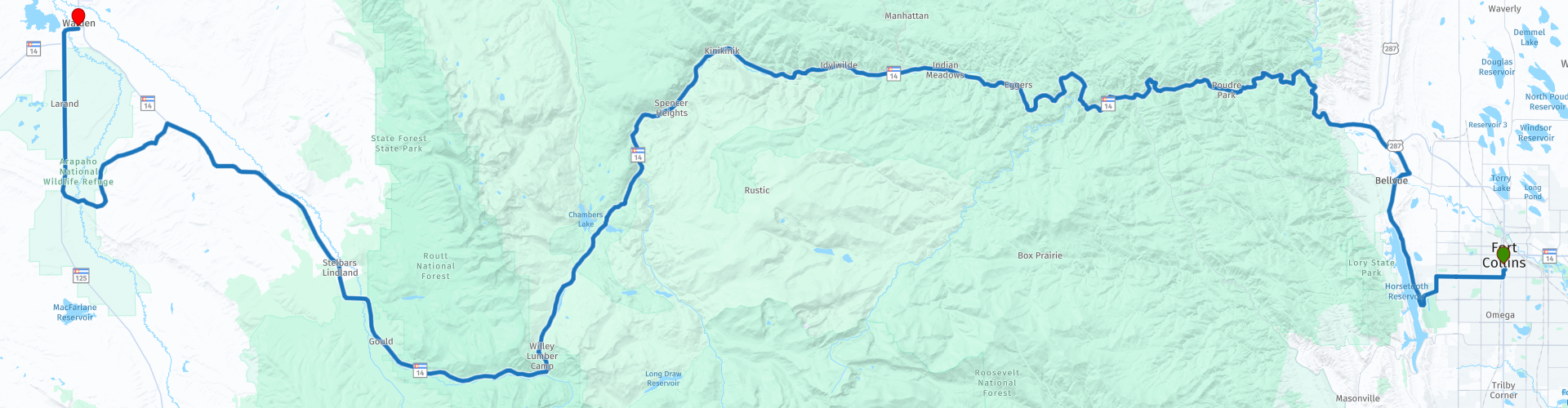
 This review describes the Cache La Poudre Scenic Byway through this beautiful nature park.
Along the way you can enjoy the beautiful nature with lots of cattle and also wildlife.
The route runs from Fort Collins through the Rocky Mountains to the town of Walden.
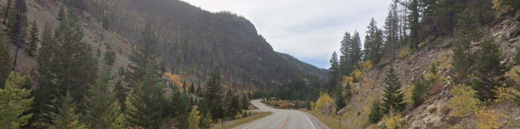
This route, with its beautiful roads through the gorges along the river interspersed with stunning greenery, deserves a 4-star rating. There aren't many attractions along the route itself, but there are several places to stop for a picnic, fishing, rafting, canoeing, or kayaking.
 Share this route


Animation

Verdict


Duration
6h 48m

Mode of travel
Car or motorcycle

Distance
185.12 km

Countries

 RouteXpert Review
 The North Park area was once home to thousands of bison that roamed the plains. Today, you'll mainly see deer, antelope, elk, beavers, and coyotes. The Cache la Poudre is now intensively managed for water management in the region. The Scenic Cache la Poudre Byway begins in Fort Collins and takes you through the Roosevelt National Forest, along the Poudre River, through Poudre Canyon to Cameron Pass, and then down to North Park.
Fishing enthusiasts are well advised to bring their gear. The clear river is easily accessible, and along the banks there are ample opportunities for trout fishing in the eddies and reservoirs, often just a short distance from the side roads.
There are also several places where you can rent a raft, canoe, or kayak to explore the river, such as the Gateway Natural Area. This is a popular spot to enjoy peace and quiet, perfect for a picnic. The city's old water filtration plant is also located here, where the North Fork of the Poudre River meets the main branch.
Another option for lunch is the Mishawaka Amphitheater, a single-stage outdoor concert venue located about 25 miles northwest of Fort Collins along Colorado State Highway 14. The complex sits directly on the banks of the Poudre River. The restaurant, with its beautiful outdoor seating, is open year-round, and the amphitheater is accessible from May through September.
We'll visit Arrowhead Lodge, originally built as a summer mountain resort. Construction began in 1933, and the lodge opened in 1935. In 1984, Arrowhead Lodge was transferred from private to public ownership through a land exchange and became the property of the US Forest Service. Today, the lodge serves as a visitor center for travelers and recreationists in the Cache la Poudre River Corridor. The staff is available to answer questions and sell forest maps and federal recreation passes. The lodge is also known as a viewing point for bighorn sheep, which can often be seen on the slopes behind the main buildings.
We drive over the impressive Cameron Pass, a mountain pass at 3,132 meters in north-central Colorado, located in the Rocky Mountains. The pass connects the south side of the Medicine Bow Mountains with the north side of the Never Summer Mountains. It lies on the border of Jackson County and Larimer County, approximately three miles north of Rocky Mountain National Park. Cameron Pass is the most direct and optimal route between Fort Collins and Walden in North Park, via State Highway 14.
As you drive the Cache la Poudre Byway, you can admire unique geological formations created by earthquakes and tectonic movements millions of years ago, such as the striking peaks of Nokhu Crags (Eagles Nest), which reach a height of 3,807 meters.
We'll also visit the Moose Visitor Center, operated by Colorado State Forest State Park and located near Gould's former logging camp. The center tells the story of the moose in North Park and the former logging camps, and also provides information about the park and its wildlife.
As we approach Walden, the Medicine Bow Mountain Range in Wyoming is visible in the distance from the Cache la Poudre Byway. Just past Walden, it's definitely worth visiting the Arapahoe National Wildlife Refuge. This nature reserve is a popular birdwatching spot. It was established to create breeding and habitat for migratory birds. Here you can observe Wilson's phalarope, black-winged avocets, willets, sandpipers, yellowlegs, dowitchers, sage grouse, golden eagles, and hawks, among others. After this final stop, we continue to the hotel in Walden.
Outdoor enthusiasts might consider planning a longer stay in this region to visit the Rawah Wilderness Area. This 120-acre (309.16 km²) area features U-shaped, glacier-carved valleys and peaks. Meltwater has created 26 lakes here, teeming with rainbow and brook trout. More than 75 miles (120 kilometers) of trails provide access to activities such as hiking, horseback riding, and cycling. In the fall, many hunters visit the area for deer and elk hunting. You can also enjoy numerous other activities, such as backpacking, climbing, kayaking, canoeing, rafting, horseback riding, birdwatching, and stargazing.
Even in winter, there's plenty of recreation to be had in the high country. Many Forest Service roads and trails are transformed into paradises for snowmobiling and cross-country skiing.


 Links
Links  Usage
Usage Want to download this route?
You can download the route for free without MyRoute-app account. To do so, open the route and click 'save as'. Want to edit this route?
No problem, start by opening the route. Follow the tutorial and create your personal MyRoute-app account. After registration, your trial starts automatically.  Disclaimer
Use of this GPS route is at your own expense and risk. The route has been carefully composed and checked by a MyRoute-app accredited RouteXpert for use on TomTom, Garmin and MyRoute-app Navigation.
Changes may nevertheless have occurred due to changed circumstances, road diversions or seasonal closures. We therefore recommend checking each route before use.
Preferably use the route track in your navigation system. More information about the use of MyRoute-app can be found on the website under 'Community' or 'Academy'.
a.jpg/800px-Maroon_Bells_(11553)a.jpg)
Colorado
About this region
Colorado is a state in the Mountain West subregion of the Western United States. It encompasses most of the Southern Rocky Mountains as well as the northeastern portion of the Colorado Plateau and the western edge of the Great Plains. Colorado is the eighth most extensive and 21st most populous U.S. state. The 2020 United States Census enumerated the population of Colorado at 5,773,714, an increase of 14.80% since the 2010 United States Census.
The region has been inhabited by Native Americans for more than 13,000 years, with the Lindenmeier Site containing artifacts dating from approximately 9200 BC to 1000 BC; the eastern edge of the Rocky Mountains was a major migration route for early peoples who spread throughout the Americas. "Colorado" is the Spanish adjective meaning "ruddy," the color of red sandstone. The Territory of Colorado was organized on February 28, 1861, and on August 1, 1876, U.S. President Ulysses S. Grant signed Proclamation 230 admitting Colorado to the Union as the 38th state. Colorado is nicknamed the "Centennial State" because it became a state one century after the signing of the United States Declaration of Independence.
Colorado is bordered by Wyoming to the north, Nebraska to the northeast, Kansas to the east, Oklahoma to the southeast, New Mexico to the south, Utah to the west, and touches Arizona to the southwest at the Four Corners. Colorado is noted for its vivid landscape of mountains, forests, high plains, mesas, canyons, plateaus, rivers, and desert lands. Colorado is one of the Mountain States and is a part of the western and southwestern United States.
Denver is the capital and most populous city in Colorado. Residents of the state are known as Coloradans, although the antiquated "Coloradoan" is occasionally used. Colorado is a comparatively wealthy state, ranking eighth in household income in 2016, and 11th in per capita income in 2010. It also ranks highly in the nation's standard of living index. Major parts of the economy include government and defense, mining, agriculture, tourism, and increasingly other kinds of manufacturing. With increasing temperatures and decreasing water availability, Colorado's agriculture, forestry and tourism economies are expected to be heavily affected by climate change.
Read more on Wikipedia
The region has been inhabited by Native Americans for more than 13,000 years, with the Lindenmeier Site containing artifacts dating from approximately 9200 BC to 1000 BC; the eastern edge of the Rocky Mountains was a major migration route for early peoples who spread throughout the Americas. "Colorado" is the Spanish adjective meaning "ruddy," the color of red sandstone. The Territory of Colorado was organized on February 28, 1861, and on August 1, 1876, U.S. President Ulysses S. Grant signed Proclamation 230 admitting Colorado to the Union as the 38th state. Colorado is nicknamed the "Centennial State" because it became a state one century after the signing of the United States Declaration of Independence.
Colorado is bordered by Wyoming to the north, Nebraska to the northeast, Kansas to the east, Oklahoma to the southeast, New Mexico to the south, Utah to the west, and touches Arizona to the southwest at the Four Corners. Colorado is noted for its vivid landscape of mountains, forests, high plains, mesas, canyons, plateaus, rivers, and desert lands. Colorado is one of the Mountain States and is a part of the western and southwestern United States.
Denver is the capital and most populous city in Colorado. Residents of the state are known as Coloradans, although the antiquated "Coloradoan" is occasionally used. Colorado is a comparatively wealthy state, ranking eighth in household income in 2016, and 11th in per capita income in 2010. It also ranks highly in the nation's standard of living index. Major parts of the economy include government and defense, mining, agriculture, tourism, and increasingly other kinds of manufacturing. With increasing temperatures and decreasing water availability, Colorado's agriculture, forestry and tourism economies are expected to be heavily affected by climate change.
View region
 Statistics
  20
20Amount of RX reviews (Colorado)
 19395
19395Amount of visitors (Colorado)
 347
347Amount of downloads (Colorado)
 Route Collections in this region
 Coast to Coast Across the USA
14 Days across the USA
Start the trip at Daytona Pier on the Atlantic Coast.
Through 14 days you will visit New Orleans, Memphis, Tulsa, Colorado Springs, Las Vegas and Los Angeles. See the sights of Monument and Death Valley, the Hoover Dam. Ride across 12 US States for 4267 miles of adventure before ending the trip on Santa Monica Pier, Los Angeles on the Pacific Coast
View Route Collection
The 10 most downloaded routes in the USA from RouteXpert Hans van de Ven
Hello and welcome to this collection of the Top 10 MyRoute app downloaded routes in USA.
There will be a great new event to be announced soon, where all these routes can be driven.
Download them all now and place them in a new "Top 10" folder, so that you always have them at hand.
If you are going to drive one of these routes in the meantime, track them with the MRA Mobile App or with MRA Navigation. Take some photos (moments) along the way as these will come in handy.
Create a travelogue of your Top 10 driven routes and add the recorded track to it.
There will also be some great prizes on offer, so keep an eye on the MRA-RouteXperts page and your mail.
The 10 routes are:
1. D13 Estes Park Denver
2. D03 Chadron Custer
3. D01 Pigeon Forge round trip through the Smokey Mountains
4. D08 Kalispell Sandpoint
5. D10 Colville Wenatchee
6. D09 Sandpoint Colville
7. D04 Custer Wall
8. D11 Wenatchee Seattle
9. D08 Cody Yellowstone NP
10.R13 San Francisco Monterey
View Route Collection