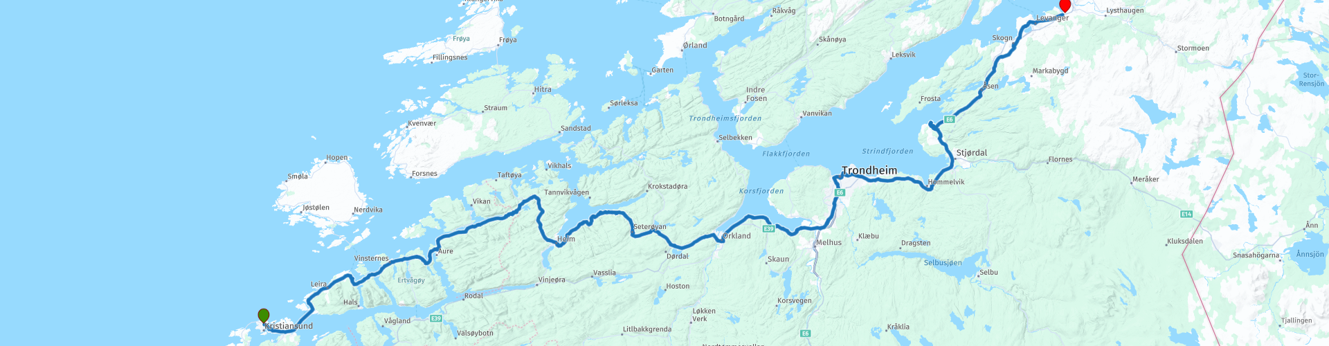
Day 03 North Cape Tour Kristiansund Trondheim Verdalsora

This route was brought to you by:
RouteXpert René Plücken (MRA Master)
Last edit: 18-12-2025
 Route Summary
 You drive longer distances in Norway without encountering a gas station or restaurant, keep this in mind before you drive. Make sure your tank is full and bring food and drinks. Bring a few bottles of water or Camel bag and fill it up when you stop to refuel. A number of breaks have been planned along the way for refueling, eating and drinking.
You have the choice to spend the night at campsites or in hotels. Hotel prices in Norway are not particularly high and breakfast is usually included. Camping is free almost everywhere, except on private property or where camping is prohibited, indicated by prohibition signs. If you don't want to camp, there are often cabins for rent on the campsites. For a trip through Norway it is always advisable to bring a tent and other camping gear.
I rate this route with 5 **** stars because of beautiful roads with many bridges, great panoramas, not to mention the visits to Trondheim and Vudduvalen.
 Share this route


Animation

Verdict


Duration
11h 7m

Mode of travel
Car or motorcycle

Distance
297.21 km

Countries

 RouteXpert Review
 After the crossing, we continue our journey on the Fylkesvei 680 (provincial road), which partly runs along the coast but also through wooded areas. We pass several lakes and cross several beautiful bridges connecting smaller islands.
We cross the Sålåsundet River via the Soleimsund Bridge. This toll-free box girder bridge is located in the municipality of Aure in Møre og Romsdal and connects Gullstein with Tustna. The bridge opened on July 1, 1978, and is approximately 340 meters long.
Next, we cross the Imarsundet River via the Imarsund Bridge, a steel box-girder bridge connecting the islands of Stabblandet and Jørnøya. The bridge was opened on January 15, 2007, by the Minister of Transport and Communications, creating a ferry-free connection from Tømmervåg to the municipal center of Aure and onward to Kyrksæterøra and Trondheim. The Imarsund Bridge is 550 meters long and has five spans, the longest of which is 120 meters. Together with the Litjsund Bridge, it replaces the former Aukan – Vinsternes ferry line, which operated only once an hour and had a crossing time of 15 minutes.
Then we cross the Litlsund via the Litjsund Bridge. This is a concrete box-section bridge with a total length of 300 meters and a main span of 160 meters. The bridge is part of the Fv680 and spans the Litlsund, a strait between the islands of Ertvågsøya and Jørnøya. The bridge is toll-free.
Next, we drive over the Mjosund Bridge (Norwegian: Mjosundbrua), a cantilever bridge that spans the Mjosundet Strait between the islands of Rottøya and Ertvågsøya, also in the municipality of Aure. Together with the Aursund Bridge, this bridge connects the mainland to Ertvågsøya. The Mjosund Bridge is 346 meters long and opened in 1995. On the other side, there's a small parking lot where you can stop for photos.
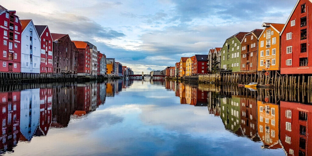
We then continue to the famous city of Trondheim, an absolute must-visit. Known for its colorful wooden houses and many excellent restaurants, it's no wonder it's considered the birthplace of Scandinavian cuisine. Here, we'll take a longer break for lunch and to stretch our legs. Take a stroll through the Bakklandet district, with its narrow, cobbled streets and characteristic wooden houses. You can also choose to rent a bike and explore the city on the locals' favorite mode of transport. If you'd like, you can even add an extra day here; Trondheim offers plenty of hotel options.
After our visit to Trondheim, we continue our journey towards our final destination, Verdalsøra, but first we visit Steinvikholm Castle, located on a small island accessible via a footbridge.
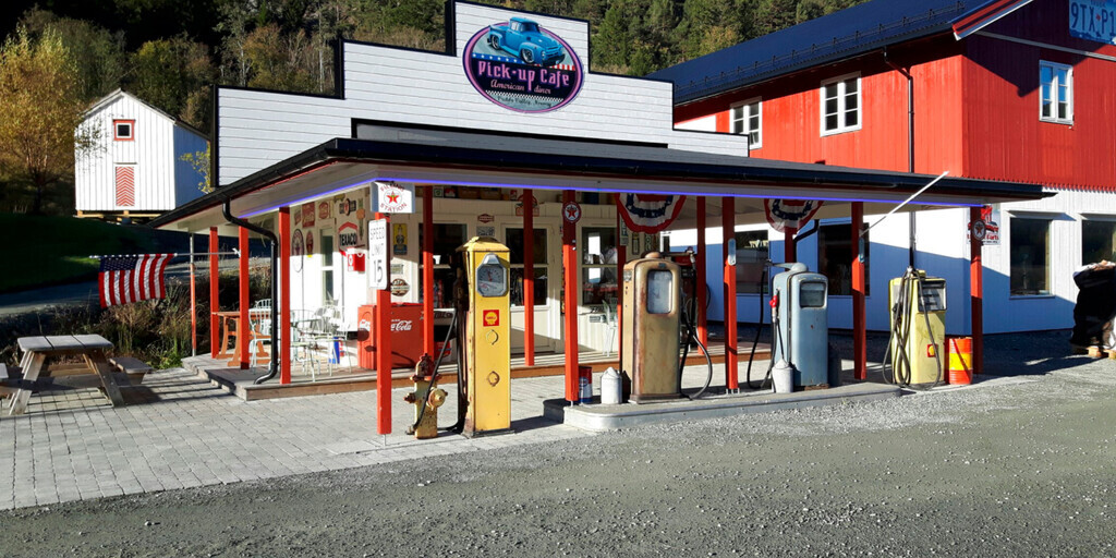
Next up is Vuddudalen (Vuddu Valley), an absolute must for Americana lovers. The American-style buildings are visible from afar. The location offers a unique and atmospheric experience, taking visitors through various decades of the 20th century. There's a museum, an American diner (Pick Up Café), and a souvenir shop. Enjoy a delicious burger and milkshake, and buy candles and gifts.
After this final stop, we'll drive via the Fv111 to Verdalsøra, the end point for the day. A faster alternative route is via the E6. In Verdalsøra, we'll spend the night at a campsite or in one of the hotels.
 Links
Links  Usage
Usage Want to download this route?
You can download the route for free without MyRoute-app account. To do so, open the route and click 'save as'. Want to edit this route?
No problem, start by opening the route. Follow the tutorial and create your personal MyRoute-app account. After registration, your trial starts automatically.  Disclaimer
Use of this GPS route is at your own expense and risk. The route has been carefully composed and checked by a MyRoute-app accredited RouteXpert for use on TomTom, Garmin and MyRoute-app Navigation.
Changes may nevertheless have occurred due to changed circumstances, road diversions or seasonal closures. We therefore recommend checking each route before use.
Preferably use the route track in your navigation system. More information about the use of MyRoute-app can be found on the website under 'Community' or 'Academy'.

Trondelag
About this region
Trøndelag (Urban East Norwegian: [ˈtrœ̂ndəˌlɑːɡ]) (Southern Sami: Trööndelage) is a county in the central part of Norway. It was created in 1687, then named Trondhjem County (Norwegian: Trondhjems Amt); in 1804 the county was split into Nord-Trøndelag and Sør-Trøndelag by the King of Denmark-Norway, and the counties were reunited in 2018 after a vote of the two counties in 2016.The largest city in Trøndelag is the city of Trondheim. The administrative centre is Steinkjer, while Trondheim functions as the office of the county mayor. Both cities serve the office of the county governor; however, Steinkjer houses the main functions.Trøndelag county and the neighbouring Møre og Romsdal county together form what is known as Central Norway. A person from Trøndelag is called a trønder. The dialect spoken in the area, trøndersk, is characterized by dropping out most vowel endings; see apocope.
Trøndelag is one of the most fertile regions of Norway, with large agricultural output. The majority of the production ends up in the Norwegian cooperative system for meat and milk, but farm produce is a steadily growing business.
Read more on Wikipedia
Trøndelag is one of the most fertile regions of Norway, with large agricultural output. The majority of the production ends up in the Norwegian cooperative system for meat and milk, but farm produce is a steadily growing business.
View region
 Statistics
  9
9Amount of RX reviews (Trondelag)
 16106
16106Amount of visitors (Trondelag)
 582
582Amount of downloads (Trondelag)
 Route Collections in this region
 In 12 Days from Oslo to the North Cape
This is a route collection of a motorcycle tour from Oslo to the North Cape, based on a journey by Thomas Falck Østli. A total of twelve routes have been described, but the tour can be extended to more days, more information about this in the reviews.
The routes run through the beautiful landscapes of Norway, including the Lofoten, with many lakes, fjords, rivers, beautiful bridges, beautiful green forests and rugged mountains. During the trip there are also many ferry crossings, keep this in mind in your planning.
You drive longer distances in Norway without encountering a gas station or a restaurant, keep this in mind before you drive. Make sure your tank is full and bring food and drinks. Bring a few bottles of water or Camel bag and fill it up when you stop to refuel. Along the way, breaks are planned for refueling, eating and drinking.
The total trip of almost 3700 kilometers is broken down as follows;
• Day 1 is a 434 kilometer drive from Oslo to Geiranger
• Day 2 is a 238 kilometer drive from Geiranger to Kristiansund
• Day 3 is a 298 kilometer drive from Kristiansund via Trondheim to Verdal
• Day 4 is a 333 kilometer drive from Verdal to Brønnøysund
• Day 5 is a 267 kilometer drive from Brønnøysund to Furøy
• Day 6 is a 296 kilometer drive from Furøy Lofoten to Reine
• Day 7 is a 218 kilometer drive from Reine to Ørsvågvær
• Day 8 is a 274 kilometer drive from Ørsvågvær to Straumsjøen
• Day 9 is a 327 kilometer drive from Straumsjøen to Senjahopen
• Day 10 is a 321 kilometer drive from Senjahopen to Tromsø
• Day 11 is a 420 kilometer drive from Tromsø to Alta
• Day 12 is a 239 km drive from Alta via the North Cape to Skarsvåg
You have the choice to stay overnight at campsites or in hotels. Hotel prices in Norway are not particularly high and breakfast is usually included.
Camping is free almost everywhere, except on private property or where camping is prohibited, indicated by prohibition signs.
If you don't want to camp, there are often cabins for rent on the campsites. For a trip through Norway it is always advisable to bring a tent and other camping gear.
Information about hotels and campsites is included in the directions
Have fun reading, planning and driving this scenic journey to the northernmost tip of Europe.
View Route Collection
6500 kilometers through Scandinavia with the highlights of the Lofoten and the North Cape
The Arctic Challenge Tour, on which this 26-part tour is partly based, is not a speed race. It's a tour. It comes down to agility, good navigation and anticipation. The participants are obliged to adhere to the speed limit of the country concerned. The participants must find the ideal route with the shortest possible distance by complying 100% with the locally applicable traffic rules. Of course, also take maximum speeds into account. The organization checks for violations of the speed limit. In case of gross or repeated exceeding of the maximum speed, disqualification for the relevant stage and for the final classification will follow. Control of the route and speeds is done by means of a track and trace system. This equipment is installed in every vehicle. You can then follow each team accurately in the Back Office. Those staying at home, interested parties and participants can also see the performances of the teams, because you can be followed live via the Internet. The Back Office takes action when a team gets into trouble. (source: website The Arctic Challenge)
That's quite a luxury, having a back office behind you that keeps an eye on you. Most of us will not have that and are on our own or the fellow traveler(s). The only agreement you have with the participants is that you also have to abide by the rules. Fortunately, you don't have to complete this tour in 9 days, like the participants, but you can take it a little longer.
The highlight of the Arctic Challenge in 2020 was the Lofoten, an island group northwest of Norway. The Lofoten archipelago is located in the middle of the wild Norwegian Sea, well above the Arctic Circle. This special region offers a beautiful landscape with imposing mountains, deep fjords and long, wild sandy beaches where the sound of the seabird colonies can always be heard.
The archipelago is best known for its rich fishing tradition. The Lofoten makes a prosperous impression despite their isolated location. The entire economy revolves above all around fishing. The image of the Lofoten is mainly dominated by wooden racks with cod, which hangs to dry. Lofoten fishing has been a household name for centuries. In the middle of winter, the ships set out to catch the fish in just a few months. The rich fishing grounds are due to the North Atlantic Warm Gulf Stream around the islands, in which the fish have their spawning grounds. Oil drilling is not permitted around Lofoten and the cod spawning grounds there.
The next destination for the participants was Sirkka, also known as Levi, a winter sports resort in Finnish Lapland. They stayed there for a few days to go ice-karting and to enjoy the snow by going on a snowmobile or skiing trip. This tour also takes you to Sirkka, but instead of staying there for a few days, you have the option to continue to the North Cape, the second highlight of this trip.
Imagine a place in the far north, where the Atlantic Ocean meets the icy waters of the Arctic Ocean. This place is the North Cape in Western Finnmark in Northern Norway. From here, only the archipelago of Spitsbergen lies between you and the North Pole and the sun shines for 2.5 months at a time; from mid-May to the end of July. Many visitors admire the midnight sun or the sunset over the Barents Sea from the North Cape plateau.
With each route you will find a review with a description of the route, where you pass and what to see along the way. It is also briefly described how the participants in the Arctic Challenge in 2020 had to drive it anyway, from which point to which point. Along the way, markings (route points) have been included that indicate the end points of the stages that the participants had to complete. As mentioned, they covered the distance in 9 days, stages of more than 1000 kilometers were no exception.
Each route ends at a hotel. It is of course not an obligation to use these hotels, you can always find another place to stay in the area, that decision is up to you. My experience, however, is that they are all simple but good hotels for a very reasonable price. They are known and can be booked at booking.com.
The routes of these collections:
R01 - Puttgarden to Angelholm, 280km
R02 - Angelholm to Alingsas, 281km
R03 - Alingsas to Mysen, 261km
R04 - Mysen to Rena, 312km
R05 - Rena to Orkanger, 306km
R06 - Orkanger to Grong, 292km
R07 - Grong to Mo i Rana, 290km
R08 - Mo i Rana to Bodo, 231km
R09 - Roundtour Bodo to Lofoten part 1, 314km
R10 - Roundtour Bodo to Lofoten part 2, 250km
R11 - Roundtour Bodo to Lofoten part 3, 291km
R12 - Bodo to Arjeplog, 295km
R13 - Arjeplog to Jokkmokk, 244km
R14 - Jokkmokk to Pajala, 239km
R15 - Roundtour Sirkka to North Cape part 1, 257km
R16 - Roundtour Sirkka to North Cape part 2, 300km
R17 - Roundtour Sirkka to North Cape part 3, 244km
R18 - Roundtour Sirkka to North Cape part 4, 275km
R19 - Roundtour Sirkka to North Cape part 5, 332km
R20 - Sirkka to Kemi, 299km
R21 - Kemi to Ylivieska, 251km
R22 - Ylivieska to Jalasjarvi, 236km
R23 - Jalasjarvi to Turku, 279km
R24 - Stockholm to Askersund, 271km
R25 - Askersund to Varnamo, 224
R26 - Varnamo to Trelleborg, 259km
Have fun driving these routes!
View Route Collection