
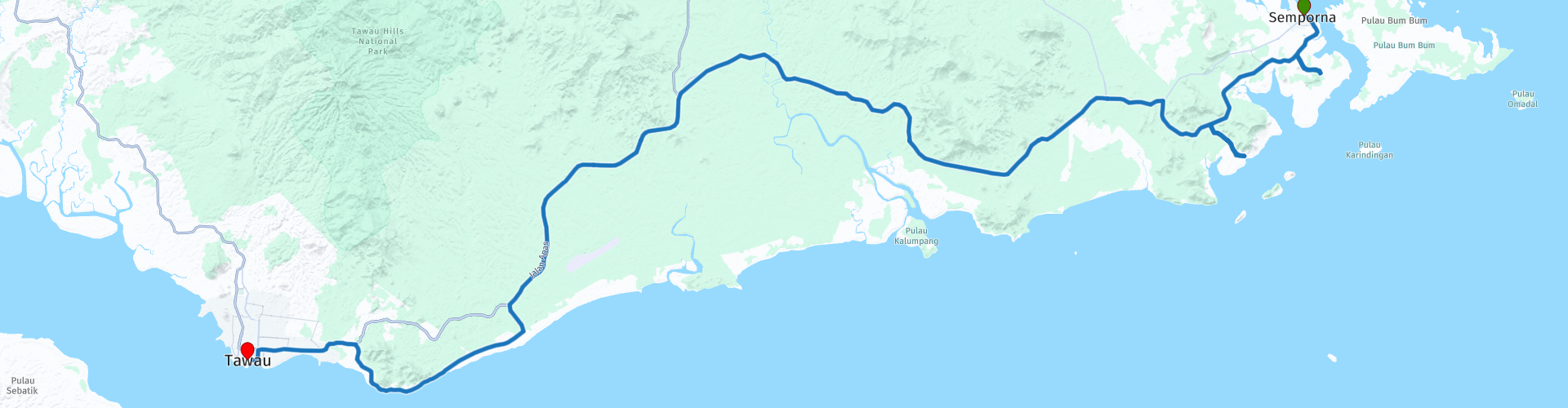
Day 6 Sabah Road Trip Semporna Tawau

This route was brought to you by:
RouteXpert René Plücken (MRA Master)
Last edit: 29-05-2026
 Route Summary
 This route was created with his permission.
Seen as one of the most beautiful provinces in Malaysia, Sabah is known for its scenic landscape with spectacular mountains, beautiful beaches, surreal sunsets, rich culture, friendliest people, winding roads, tall waterfalls, national parks and much more!
The roads in Malaysia are generally in good condition, but beware; there are also parts where the asphalt is poor and there can be potholes in the road surface. This can be dangerous, so caution is advised. During the rainy season (September-December) the roads can be slippery. Traffic in Malaysia drives on the left side of the road.
You can rent a motorcycle in Malaysia, but these are usually lighter models and often scooters. You can spend the night in hotels, B & Bs or campsites, which can easily be booked via the website in the review or via booking.com.
I rate this route with 4 **** stars because of the good roads, but also a part of the highway, the beautiful nature, sights and activities that you can undertake.
 Share this route


Animation

Verdict


Duration
7h 21m

Mode of travel
Car or motorcycle

Distance
133.39 km

Countries

 RouteXpert Review
 The first stop is scheduled after just 15 minutes of driving at the Bukit Tengkorak Archaeological Heritage Site, also known as Skull Hill in Semporna. Please note that TomTom does not know the way.
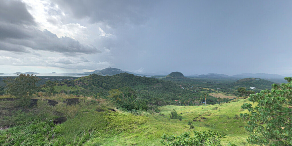
Skull Hill (Malay: Bukit Tengkorak) is an archaeological site approximately 10 kilometers south of the city of Semporna. This is a great spot for a short walk to the top of the hill. The walk takes about 15 minutes. The view from the top is beautiful. If you enjoy photography, this place is highly recommended.
The hill is composed of volcanic rock, and the part of the volcano's rim has a diameter of 2 kilometers (1.2 miles). It is surrounded by numerous hills and mountains, most of which are extinct volcanoes ranging in age from the Pliocene (5.33 to 2.58 million years ago) to the Quaternary (2.58 million years ago to the present).
Between 1994 and 1995, joint archaeological research was conducted on the hill by the Centre for Archaeological Research of Malaysia and the Sabah Museum team. During the excavations, a wide range of archaeological material was recovered, including large quantities of pottery shards, flint, stone tools made of agate and obsidian, a polished stone axe, a stone mallet made of tree bark cloth, and several artifacts of shells and bones. An abundance of food remains was also discovered, primarily marine molluscs, fish bones, and some bones of land animals.
The slopes of the hills are strewn with numerous pottery shards featuring various patterns. An ethno-archaeological study shows that pottery making is still practiced to this day by the Bajau community in Semporna. This pottery site has ties between local communities and traders from across the Andaman Sea. The hill bears witness to prehistoric maritime trade and one of the world's longest human movements, dating back 3,000 years.
After driving for about 1 hour and 30 minutes through the beautiful green nature of Sabah, we arrive at a true gem: Tanjung Parapat, also known as the Water Village. Please note: TomTom does not recognize this road.
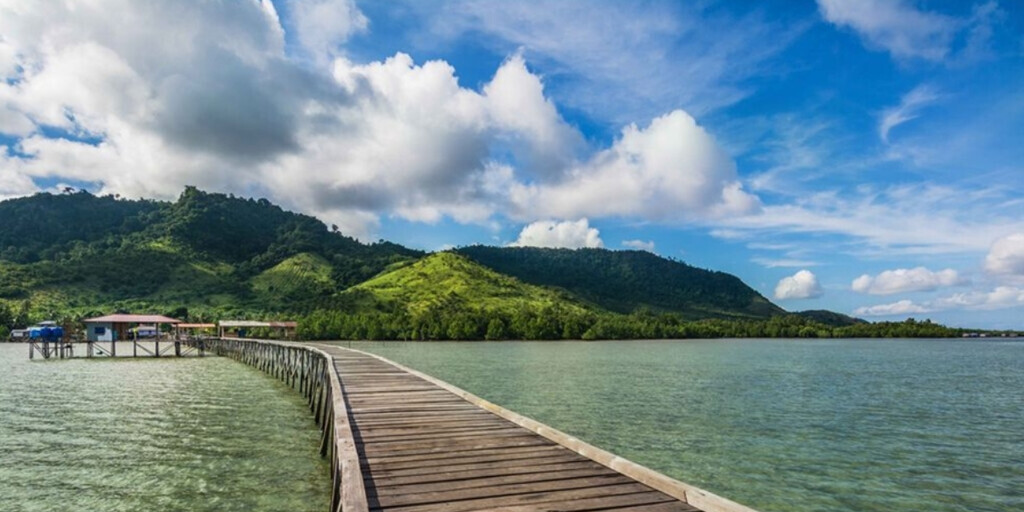
Tanjung Parapat is actually a small Muslim village situated on a coastal strip with very shallow sea; the inhabitants are all Bajau people. The seabed near the land at Tanjung Parapat is sandy and flat, and you will not find any reefs or corals there, only sand and stones. The fishermen from this village built a long wooden jetty so that they can moor their boats in deeper water; the jetty extends about a hundred meters from the land.
Most people come here on weekends with friends and family members to enjoy the beautiful view. There are no cafes or restaurants, hotels, or other accommodations nearby, so few tourists come here. Most people who come here are locals. The view is so enchanting and so refreshing, especially early in the morning and in the evening during sunset.
We drive back to the main route and stop briefly at the Kedai Runcit Rosmah grocery store for something to drink and eat. After driving for 10 minutes, we turn onto the SA51. This two-lane road through the beautiful green countryside, with many palm trees, is easy to drive on from Sabah, but there isn't much of interest to stop for along the route, so drive and enjoy the beautiful scenery.
After driving about 50 kilometers, we stop for lunch at Restaurant Checkpoint, at a small roundabout where the SA51 merges into Highway 13. After lunch, we take the four-lane Highway 13; unfortunately, there is no other option. After about 20 kilometers, we take the exit and continue driving along the beautiful winding Jalan Apas Wakuba and Jalan Kampung Batu Payung along the coast. TomTom and HERE have some trouble following the latter road, but the road is open to motorized traffic in both directions.
Two more short stops are planned in Tawau: the first at the Sea View Café for a drink while enjoying the beautiful view, and the second to photograph the Guan Yin Temple.
After this last stop, it is another 40-minute drive to the center of Tawau, where you can spend the night in one of the many hotels.
Tawau is the third largest city in Sabah after Kota Kinabalu and Sandakan. Located in the southeastern region of Sabah, across the border from Kalimantan, Indonesia, and a 30-minute boat ride from the Philippines, Tawau is known for its seafood and cocoa plantations. There are attractions in Tawau that make it a good place to stop for 1 or 2 nights before or after a trip to nearby attractions such as the Semporna Islands, the Maliau Basin, and the Danum Valley.
 Links
Links  Usage
Usage Want to download this route?
You can download the route for free without MyRoute-app account. To do so, open the route and click 'save as'. Want to edit this route?
No problem, start by opening the route. Follow the tutorial and create your personal MyRoute-app account. After registration, your trial starts automatically.  Disclaimer
Use of this GPS route is at your own expense and risk. The route has been carefully composed and checked by a MyRoute-app accredited RouteXpert for use on TomTom, Garmin and MyRoute-app Navigation.
Changes may nevertheless have occurred due to changed circumstances, road diversions or seasonal closures. We therefore recommend checking each route before use.
Preferably use the route track in your navigation system. More information about the use of MyRoute-app can be found on the website under 'Community' or 'Academy'.
Changes may nevertheless have occurred due to changed circumstances, road diversions or seasonal closures. We therefore recommend checking each route before use.
Preferably use the route track in your navigation system. More information about the use of MyRoute-app can be found on the website under 'Community' or 'Academy'.
 Nearby routes
Sabah
About this region
Sabah (Malay pronunciation: [saˈbah]) is a state of Malaysia located on the northern portion of Borneo, in the region of East Malaysia. Sabah has land borders with the Malaysian state of Sarawak to the southwest and Indonesia's Kalimantan region to the south. The Federal Territory of Labuan is an island just off the Sabah coast. Sabah shares maritime borders with Vietnam to the west and the Philippines to the north and east. Kota Kinabalu is the state capital city, the economic centre of the state, and the seat of the Sabah state government. Other major towns in Sabah include Sandakan and Tawau. The 2015 census recorded a population of 3,543,500 in the state, and in 2019 it was estimated to have grown to over 3.9 million. Sabah has an equatorial climate with tropical rainforests and abundant animal and plant species. The state has long mountain ranges on the west side which forms part of the Crocker Range National Park. Kinabatangan River, the second longest river in Malaysia runs through Sabah, and Mount Kinabalu is the highest point of Sabah as well as of Malaysia.
The earliest human settlement in Sabah can be traced back to 20,000–30,000 years ago along the Darvel Bay area at the Madai-Baturong caves. The state has had a trading relationship with China starting from the 14th century AD. Sabah came under the influence of the Bruneian Empire in the 14th and 15th centuries, while the eastern part of the territory was given to the Sultanate of Sulu because the Sultanate had helped the Bruneian empire in a battle and as such it was given to them as a gift between the 17th and 18th centuries. The state was subsequently acquired by the British-based North Borneo Chartered Company in the 19th century. During World War II, Sabah was occupied by the Japanese for three years. It became a British Crown Colony in 1946. On 31 August 1963, Sabah was granted Independent and self-government by the British. Following this, Sabah became one of the founding members of the Federation of Malaysia (established on 16 September 1963) alongside Sarawak, Singapore (expelled in 1965), and the Federation of Malaya (Peninsular Malaysia or West Malaysia). The federation was opposed by neighbouring Indonesia, which led to the Indonesia–Malaysia confrontation over three years along with the threats of annexation by the Philippines along with the Sultanate of Sulu, threats which continue to the present day.Sabah exhibits notable diversity in ethnicity, culture and language. The head of state is the Governor, also known as the Yang di-Pertua Negeri, while the head of government is the Chief Minister. The government system is closely modelled on the Westminster parliamentary system and has one of the earliest state legislature systems in Malaysia. Sabah is divided into five administrative divisions and 27 districts. Malay is the official language of the state; and Islam is the state religion, but other religions may be practised in peace and harmony in any part of the state. Sabah is known for its traditional musical instrument, the sompoton. Sabah has abundant natural resources, and its economy is strongly export-oriented. Its primary exports include oil, gas, timber and palm oil. The other major industries are agriculture and ecotourism.
Read more on Wikipedia
The earliest human settlement in Sabah can be traced back to 20,000–30,000 years ago along the Darvel Bay area at the Madai-Baturong caves. The state has had a trading relationship with China starting from the 14th century AD. Sabah came under the influence of the Bruneian Empire in the 14th and 15th centuries, while the eastern part of the territory was given to the Sultanate of Sulu because the Sultanate had helped the Bruneian empire in a battle and as such it was given to them as a gift between the 17th and 18th centuries. The state was subsequently acquired by the British-based North Borneo Chartered Company in the 19th century. During World War II, Sabah was occupied by the Japanese for three years. It became a British Crown Colony in 1946. On 31 August 1963, Sabah was granted Independent and self-government by the British. Following this, Sabah became one of the founding members of the Federation of Malaysia (established on 16 September 1963) alongside Sarawak, Singapore (expelled in 1965), and the Federation of Malaya (Peninsular Malaysia or West Malaysia). The federation was opposed by neighbouring Indonesia, which led to the Indonesia–Malaysia confrontation over three years along with the threats of annexation by the Philippines along with the Sultanate of Sulu, threats which continue to the present day.Sabah exhibits notable diversity in ethnicity, culture and language. The head of state is the Governor, also known as the Yang di-Pertua Negeri, while the head of government is the Chief Minister. The government system is closely modelled on the Westminster parliamentary system and has one of the earliest state legislature systems in Malaysia. Sabah is divided into five administrative divisions and 27 districts. Malay is the official language of the state; and Islam is the state religion, but other religions may be practised in peace and harmony in any part of the state. Sabah is known for its traditional musical instrument, the sompoton. Sabah has abundant natural resources, and its economy is strongly export-oriented. Its primary exports include oil, gas, timber and palm oil. The other major industries are agriculture and ecotourism.
View region
 Statistics
  11
11Amount of RX reviews (Sabah)
 11232
11232Amount of visitors (Sabah)
 304
304Amount of downloads (Sabah)
 Route Collections in this region
 The best Sabah Road Trip Borneo Malaysia
Based on the routes of “Rider Chris” from Kuala Lumpur Malaysia, this 11-day Motorcycle Tour in Sabah Borneo is a passionate motorcyclist and loves to share his travel adventures with the community through his website and social media. The link to his website can be found in the first route.
This route collection was created with his permission.
Seen as one of the most beautiful provinces in Malaysia, Sabah is known for its scenic landscape with spectacular mountains, beautiful beaches, surreal sunsets, rich culture, friendliest people, winding roads, tall waterfalls, national parks and much more!
The roads in Malaysia are generally in good condition, but beware; there are also parts where the asphalt is poor and there can be potholes in the road surface. This can be dangerous, so caution is advised. During the rainy season (September-December) the roads can be slippery. Traffic in Malaysia drives on the left side of the road.
You can rent a motorcycle in Malaysia, but these are usually lighter models and often scooters. You can spend the night in hotels, B & Bs or campsites, which can easily be booked via the website in the review or via booking.com.
This route collection was created with his permission.
Seen as one of the most beautiful provinces in Malaysia, Sabah is known for its scenic landscape with spectacular mountains, beautiful beaches, surreal sunsets, rich culture, friendliest people, winding roads, tall waterfalls, national parks and much more!
The roads in Malaysia are generally in good condition, but beware; there are also parts where the asphalt is poor and there can be potholes in the road surface. This can be dangerous, so caution is advised. During the rainy season (September-December) the roads can be slippery. Traffic in Malaysia drives on the left side of the road.
You can rent a motorcycle in Malaysia, but these are usually lighter models and often scooters. You can spend the night in hotels, B & Bs or campsites, which can easily be booked via the website in the review or via booking.com.
View Route Collection