Cathar Castles from Carcasonne

This route was brought to you by:
RouteXpert Jan Koelstra - Senior Rx
Last edit: 17-03-2025
 Route Summary
 It is the northern route belonging to a collection of three tours through Cathar country.
Given the strategic positions of the fortresses, you can expect many hairpin bends. Once parked at the castles, you often have to climb quite a bit to see them. Take your time for this ride, which takes you through the hills of the Montagne Noire.
The route certainly deserves 5 stars because you will never tire of looking at the road, the rugged terrain, the castles or what is left of them and the mountains.
Special feature
inspiration tip: The comic strip "The Last Cathar" by Eric Lambert, Arnaud Delalande and Bruno Pradelle, publisher Glénat. (last link in Review)
 Share this route


Animation

Verdict


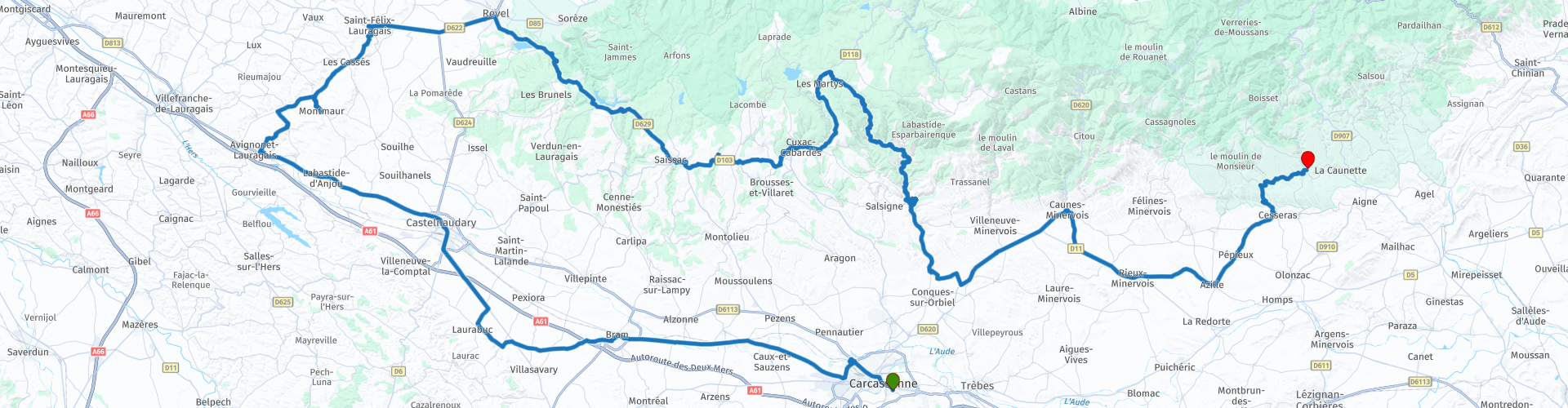
Duration
8h 21m

Mode of travel
Car or motorcycle

Distance
204.46 km

Countries

 RouteXpert Review
 Given the strategic positions of the fortresses, you can expect many hairpin bends. Once you reach the castles, you often have to climb quite a bit. For a visit, bring good walking shoes and time for this route, which takes you through the hills of the Montagne Noire. The department of Aude publishes a brochure: 'ltinéraires en Pays d'Aude: sur les traces des Cathares'. Here you will find more Cathar sites listed.
Carcassonne is the starting point of the tour, just before the ramparts.
The city actually consists of two cores: the 'cité', the fairytale and fortified model town from the Middle Ages and the Ville Basse, which was set up as a bastide. First there was the cité, with a single wall, built around the count's castle of the Trencavels. This Carcassonne enjoyed a prosperity that ended abruptly with the Albigensian Crusade. Under the leadership of Simon de Montfort, the crusaders gathered in 1209 at the foot of the Cathar stronghold and waited until the water of the cité ran out. Raymond-Roger Trencavel finally surrendered. A few decades later, his son felt he had to reclaim the lost city. With the help of the inhabitants of the cité, he tried to make the city his own. The attempt failed and Louis IX banished the disloyal inhabitants for a period of seven years. After that, the Carcassonners did return, but they were no longer allowed to settle in the safe, now double-walled cité. This is how the Ville Basse came into being, laid out as a bastide with a market square, straight streets and its own wall (now boulevards). Thanks to the fortifications of the cité, Carcassonne proved to be impregnable. Anyone who broke through the first ring of walls was bombarded from the second ring. You will only find such a large number of battlements, pepper pot turrets, massive gates and walls here. The 19th-century restorations have greatly improved the appearance. In fact, the cité could serve as a sublime location for a film about city life in the Middle Ages.
On the outskirts of town you will have the opportunity to refuel and enjoy the capricious route to Saissac. But first you will pass the remarkable Bram.
Bram
From the 11th century onwards, a place with the short name Bram emerged, whose circular plan around the place of worship would extend in successive rings to form the largest circular village in Europe. In 1210, at the beginning of the Albigensian Crusade, the fortified village of Bram was besieged by Simon de Montfort. After a three-day siege, about 100 inhabitants were taken prisoner. For good measure, the Cathars were blinded in the eyes, their noses and lips cut off. Only one of them was spared an eye to lead an ominous procession to the Chateau de Lastours further away and announce the arrival of the crusaders.
Avignonet-Lauragais
From far and wide, the visit to the village begins with a view of the bell tower of the church Notre Dame des Miracles in Avignonet. As you walk through the streets, you will notice that the buildings are made of white stone (limestone sandstone to be precise). Unlike the other villages in the south of Toulouse, all built in pink brick. From far and wide, the visit to the village begins with a view of the bell tower of the church Notre Dame des Miracles in Avignonet. As you walk through the streets, you will notice that the buildings are made of white stone (limestone sandstone to be precise). Unlike the other villages in the south of Toulouse, all built in pink brick.
In the 13th century, Avignonet-Lauragais was the scene of a massacre of inquisitors appointed by the Catholic Church to hunt down Cathars. It must be said that the inquisitors were feared by the population, who were on the side of the Cathars. When they arrived, a heavy silence fell over the village, because everyone knew that only two testimonies were needed to end up at the end of a rope or in the fire. It was the responsibility of the inquisitors to make even the most recalcitrant renounce their Cathar faith, without hesitation resorting to blackmail and torture to obtain confessions.
Thanks to the complicity of the inhabitants, Cathar knights led by Faydit discreetly reached the castle where the inquisitors were housed. They ran down a staircase, smashed the doors and finally entered the room where the inquisitors were sleeping. A dozen axes fell on them, it was a massacre!
As you can imagine, the reprisals were very hard on the villagers who were complicit in this massacre. The church was closed for forty years. During the reopening, several miracles were told: the bells rang day and night and one morning a golden statue of the Virgin was discovered on the porch. The current church was renovated in the 14th and 15th centuries and has been called "Our Lady of Miracles" ever since. A painting of this event hangs in the church. Many of the murderers sought refuge in Italy. This is probably why the pepper pot tower is also called "Lombarde Gate". A scent of Italy floats in Avignonette.
Saint-Felix-Lauragais
This beautiful fortified town of the Pays de Cocagne, surrounded by fields of wheat and sunflowers, offers a visit to its charming square with covered market under which old timber-framed houses rise. The town of Saint-Félix-Lauragais, which was the seat of the first council of the Cathars in 1167, invites you to discover its collegiate abbey from the 14th century, its castle and its view of the Black Mountain and the Pyrenees.
Saissac
Saissac is considered one of the most picturesque places in the Montagne Noire. Forests and meadows surround the old lordship of the Counts of Carcassonne. Those interested in daily life on the 'Black Mountain' can visit one of the two towers. Above the town, a sound and light show is performed in the castle in the summer. The complex began as a Cathar stronghold and was considerably expanded in the course of the 16th century. Only the keep and the eastern towers actually date from the Cathar period.
Last tours
The lords of Cabaret built no less than four castles on the same rock base: Cabaret, Tour Régine, Fleur d'Espine and Quertinheux. Simon de Montfort failed twice on the four fortified residential towers. He only got them into his possession after the lords surrendered. This is where lunch is planned.
Caunes-Minervois
is a small wine village in the central northern part of the Aude department. The village is built at the foot of the Montagne Noir and is located in the middle of the Minervois wine region. The most famous sight is the abbey.
The history of Caunes-Minervois goes back to the second half of the 8th century, when a Benedictine abbey was built. This abbey was founded by Abbot Anian, on a site where the remains of a Roman estate stood. Shortly after the abbey was founded, it came under the protection of Charlemagne, who donated a large part of his war booty to build the abbey. Not much of the original abbey from the 8th century has been preserved. Only under the abbey church, some remains of a masonry wall can now be seen. Of the parts that were built in the 11th, 14th and 17th centuries, there is still plenty to see in the renovated abbey. One of the most beautiful parts is the old cloister. You are invited to visit the abbey and/or take a break on a terrace. You can also save the next opportunity for a drink for the end point.
In the immediate vicinity of Caunes-Minervois you will find some of the most important marble mines in France. In these mines the famous red marble is extracted, which you will find in many places in the region. In Caunes-Minervois you can see beautiful sculptures and carvings in this typical Languedoc marble all over the village. The colour of this marble varies from light pink to blood red. Marble from Caunes-Minervois has been used in several famous places in the world. Think of the Mezquita in Cordoba, the Grand Trianon in the palace garden of Versailles and the Saint Peter's Basilica in Rome.
Minerva
The gorges of the Cesse and Brian separate the tiny 'rock city' from the limestone plateaus. In the 11th century, Minerve was founded on this unique spot. Although the fortifications were dismantled in the 17th century on the orders of Louis XIII, the streetscape still has a medieval appearance. Minerve became a refuge for Cathars who hastily retreated after the fall of 'their' Béziers. Very typical are the 'ponts naturels': the river Cesse has carved two natural bridges out of the rock, a small one and a large one of 200 m. After a visit to this fortress, it is nice to relax in one of the local catering establishments.


 Links
Links  Usage
Usage Want to download this route?
You can download the route for free without MyRoute-app account. To do so, open the route and click 'save as'. Want to edit this route?
No problem, start by opening the route. Follow the tutorial and create your personal MyRoute-app account. After registration, your trial starts automatically.  Disclaimer
Use of this GPS route is at your own expense and risk. The route has been carefully composed and checked by a MyRoute-app accredited RouteXpert for use on TomTom, Garmin and MyRoute-app Navigation.
Changes may nevertheless have occurred due to changed circumstances, road diversions or seasonal closures. We therefore recommend checking each route before use.
Preferably use the route track in your navigation system. More information about the use of MyRoute-app can be found on the website under 'Community' or 'Academy'.

Occitanie
About this region
Occitanie (French pronunciation: [ɔksitani] (listen); Occitan: Occitània [utsiˈtanjɔ]; Catalan: Occitània [uksiˈtaniə]), Occitany or Occitania (), is the southernmost administrative region of metropolitan France excluding Corsica, created on 1 January 2016 from the former regions of Languedoc-Roussillon and Midi-Pyrénées. The Council of State approved Occitanie as the new name of the region on 28 September 2016, coming into effect on 30 September 2016.The modern administrative region is named after the larger cultural and historical region of Occitania, which corresponds with the southern third of France. The region Occitanie as it is today covers a territory similar to that ruled by the Counts of Toulouse in the 12th and 13th centuries. The banner of arms of the Counts of Toulouse, known colloquially as the Occitan cross, is used by the modern region and is also a popular cultural symbol. In 2015, Occitanie had a population of 5,839,867.
Read more on Wikipedia
View region
 Statistics
  83
83Amount of RX reviews (Occitanie)
 32278
32278Amount of visitors (Occitanie)
 4416
4416Amount of downloads (Occitanie)
 Route Collections in this region
 25 Magnificent trails in France
This MRA route collection contains 25 beautiful motorcycle routes in different parts of France, such as the Ardennes, the Alsace, Vercors, the Drôme, the Ardèche, Cote d'Azure, Gorges du Verdon, the Ariège, the Dordogne and Brittany.
The routes have been carefully created by Bert Loorbach, who is an enthusiastic motorcyclist himself. He lived in France for a year and a half, during which time he devoted himself to mapping the unknown and beautiful back roads of France especially for motorcyclists.
The routes are bundled in the Motortourgids France part 1 of Kosmos publishing house and now also available in MyRouteApp.
I have taken over the routes in MRA and sometimes adjusted them slightly to make them even more interesting for the motorcyclist.
View Route Collection
24 Magnificent trails in France
It is clear that France is one of the most beautiful and best touring countries. It offers an incredibly varied landscape with good roads and a pleasant climate. It is not for nothing that you see so many motorcyclists there. My previous collection of 25 routes in France (25 Magnificent routes in France) were based on the route descriptions from the Motortourgids France part 1 made by Bert Loorbach.
This collection of 24 routes comes from Motortourgids France part 2. In this collection, a difference has been made between approach routes and motorcycle tours in a certain area. The approach routes can also be used in combination with the routes from Motortourgids France part 1
The routes are sometimes slightly adjusted based on the tips that Bert Loorbach gives in his description, or because of another place to spend the night, or to reach the minimum length of 2 hours for the MRA Library. For each route, the review contains a more detailed description, including options to stay overnight or places of interest along the way, which are also indicated with a POI and if possible with a short description.
Two or more routes have been created for a number of areas, such as for Burgundy, Auvergne, The Alps, Tarn and Cévennes and Nord-Pas de Calais. These routes can be nicely combined in a multi-day trip.
View Route Collection