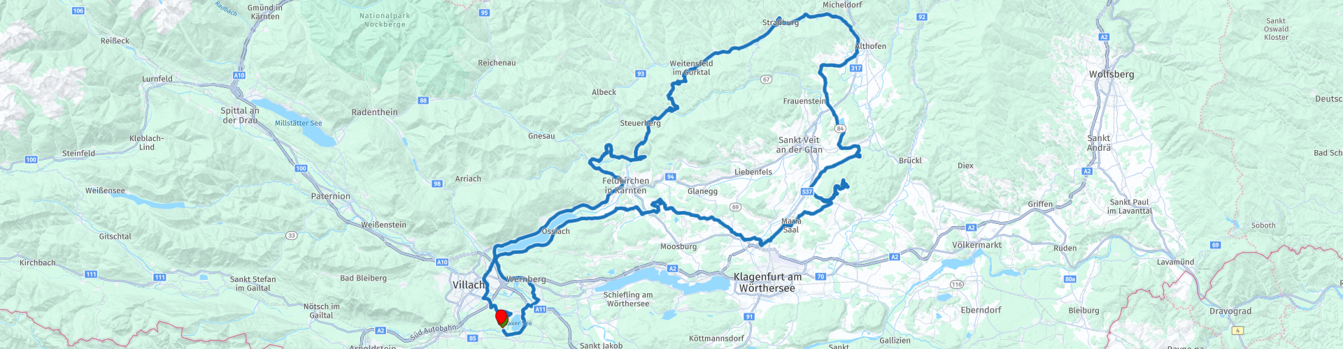
Roundtrip Faak am See via Magdalensberg

This route was brought to you by:
RouteXpert Albert van den Elsen
Last edit: 29-12-2023
 Route Summary
 On this tour you drive through the mountain area 'Biospharenpark Nockenalm', where you can experience nature in all its facets. You pass dense forests, vast alpine pastures, steep rock walls and clear lakes.
The highlight of this tour is the Magdalensberg, the top of a mountain where you are rewarded with a breathtaking view of the surrounding landscape. The view is so impressive that you will never forget it.
My memories of this route a few years ago are still so vivid that I would like to share them with you. Some sights have been added here and there to make the route even more interesting.
From the beginning to the end you drive on roads that are accessible to everyone.
In addition, this tour is very suitable for less experienced riders, because there are not many sharp hairpin bends.
It is inevitable that this ride will be awarded 5 stars.
Start - End point: Start - end: Pension Ferienhaus Tannenheim, Faak am See
Note!
Please note that if you have to deviate from the route and use the highway, a vignette may be required.
 Share this route


Animation

Verdict


Duration
7h 33m

Mode of travel
Car or motorcycle

Distance
210.98 km

Countries

 RouteXpert Review
 The start of this impressive tour is at your accommodation address.
The route takes you past lakes, forests and hills and you see the world pass by in all its beauty.
The visits to various cultural heritages, such as castles and castles, offer a rich addition to your experience.
The first part of the route takes you past the 220 hectare Faaker See, whose water has a turquoise color. This color is caused by the presence of limestone in the soil.
The area around the lake is also known for the motorcycle event called 'European Bike Week', which is organized by Harley Davidson every year in the first week of September. With its 200,000 visitors, this event is the third largest Harley event in the world after Sturgis (USA) and Daytona (USA) and is very popular among Harley enthusiasts and is also a major source of income for the local catering industry.
After Lake Faaker See you follow the sloping road, between the Tauernwald and Lake Ossiach, through the many typical Austrian villages whose architectural styles are characteristic.
The Ossiacher See is 10 kilometers long and 3 kilometers wide and has an area of 1078 hectares. This makes it the third largest lake in Carinthia, measured by length and width.
The lake is surrounded by five villages including Annenheim, Sattendorf and Bodensdorf and with its crystal clear waters it is a popular destination for water sports enthusiasts.
Every year this lake is visited by many tourists looking for peace and nature, it is an important part of the local economy, and it contributes to the many jobs in the tourism sector.
After a coffee stop at the small Maltschacher See near Maltschach, you drive through an overwhelming area past the Freudenberg, Zmulnberg and Tentschacher and turn at Klagenfurt towards Ottmanach.
A beautiful route takes you along the winding mountain roads of the Krücke and the Zechnerkogel, after which the next stop, on top of the Magdalensberg, which rises 1059 meters above sea level, comes into view.
The climb to the mountain top, both up and down, is an enchanting experience in itself. Especially in the last part you can already enjoy fragments of the breathtaking view that you will see from above.
On the mountain you will find the St. Magdalene Church and the hotel 'das Gipfelhaus'.
This environment is an oasis of peace and quiet, where noise, exhaust fumes and crowds have no place.
The hotel has been run by the Gruber family since 1926 and has built up an excellent reputation as a restaurant and accommodation for activities, wellness, parties and functions.
A little history about the location should of course not be missed.
The hill has been inhabited since prehistoric times and was an important trading and military settlement in Roman times. The church on this mountain is an important attraction with a rich history dating back to the 14th century and plays a major role in the local community. Church services, weddings and other religious ceremonies are held regularly, in which both locals and visitors can participate.
You will also find a Celtic bronze statue depicting a bull. The statue is approximately 1.5 meters high and weighs 800 kilos. It was found in 1972 during excavations on the Magdalensberg.
In addition to a great lunch, take the time to enjoy this area, just walk around and take pictures of the views this location offers you.
After the lunch stop, follow the road along the Zechnerkogel and Rainkogel before arriving at the parking lot at the impressive high-altitude castle Schloss Hochosterwitz. This castle, which towers on a 172 meter high limestone rock above the village of Sankt Georgen am Längsee, was expanded in the 12th century to become an important center of power in the region and was repeatedly besieged during the 14th and 15th centuries. But thanks to its strong defenses it managed to hold out.
With 14 gates connected by stairs, the castle is well fortified. The castle also houses a museum with a collection of weapons, armor and medieval objects.
Entrance to the castle is not free. You can climb up on foot, but that takes a lot of time. Another option is to take the elevator, but you have to pay for it.
Still, it is definitely worth visiting this location.
After this visit you drive along a winding road through the Wolschartwald and along the Längsee, after which after some time you will see the 'Schloss Pöckstein' castle appearing along the road at Pöckstein-Zwissenwässern, located in the Siebenbrunwald.
This castle distinguishes itself from other castles by its striking appearance. While simplicity often prevails in other castles, this example stands out because of its beautiful appearance.
Schloss Pöckstein dates back to the 18th century and is today used as an events venue. This was once the residence of the Gurker bishops who played an important role in the history of Carinthia.
Next to this castle there is also a chapel and a beautiful garden where open-air theater performances are held regularly. Visit the castle, take a walk through the garden and enjoy the surroundings before continuing your journey.
The winding roads between the forests give you an enchanting impression of the surroundings. Once at the town of Straßburg you will visit the next castle, called 'Schloss Straßburg'. This 12th century castle also belonged to the Gurker Bishops.
Today it houses several museums and collections of objects from different cultures.
Once you have completed this visit, you continue through the Lower Heidenwälder forest to the town of Weitensfeld im Gurtal.
After this, the route winds between the mountains to your last coffee stop. After this short break, you will then visit the nearby Schloss Lang, built in the 12th century.
This medieval castle offers beautiful views over the Gailtal valley and is also a popular tourist attraction. The castle was built by the 'der Lang' family and later became the property of the der Khevenhüller family in the 19th century, who restored the castle to its current form. This is another photo opportunity.
'Schloss Biberstein', whose origins date back to the 14th century, is your next cultural experience.
The castle is now a private home and therefore no longer publicly accessible. Don't let that discourage you, though; feel free to walk around to admire this beautiful historic piece of architecture and enjoy the view over the village of Himmelberg and the surrounding landscape.
The end of the tour slowly comes into view after you drive towards the Ossiachersee near Feldkirchen.
Via several small villages, all of which are located on the north side of the lake, you drive at the other end of the Ossiacher See into the larger town of Villach where you have a fuel stop. After a few kilometers you finally arrive at the start and end point of this tour: Pension Feriënhaus Tannenheim.
Your stay at this accommodation guarantees a homely feeling.
The owners are friendly, the rooms are clean and affordable and they serve a good breakfast in the morning.
Due to the lack of a restaurant, you will have to find another place to eat something. Fortunately, there is no shortage of that because the first restaurant is a 3-minute walk away.
To end the day, put your motorcycle aside and take the opportunity to relive this tour in your mind while enjoying a cool refreshment. You can only conclude that this trip was a gigantic experience. Touring winding roads, visiting various castles and lunch at the highlight 'the Magdalensberg' will be a place in your memory that you will not soon forget and that you are guaranteed to talk about often.


 Links
Links  Usage
Usage Want to download this route?
You can download the route for free without MyRoute-app account. To do so, open the route and click 'save as'. Want to edit this route?
No problem, start by opening the route. Follow the tutorial and create your personal MyRoute-app account. After registration, your trial starts automatically.  Disclaimer
Use of this GPS route is at your own expense and risk. The route has been carefully composed and checked by a MyRoute-app accredited RouteXpert for use on TomTom, Garmin and MyRoute-app Navigation.
Changes may nevertheless have occurred due to changed circumstances, road diversions or seasonal closures. We therefore recommend checking each route before use.
Preferably use the route track in your navigation system. More information about the use of MyRoute-app can be found on the website under 'Community' or 'Academy'.

Carinthia
About this region
Carinthia (German: Kärnten [ˈkɛʁntn̩] (listen); Slovene: Koroška [kɔˈɾóːʃka] (listen)) is the southernmost Austrian state or Land. Situated within the Eastern Alps, it is noted for its mountains and lakes. The main language is German. Its regional dialects belong to the Southern Bavarian group. Carinthian Slovene dialects, forms of a South Slavic language that predominated in the southeastern part of the region up to the first half of the 20th century, are now spoken by a small minority in the area.
Carinthia's main industries are tourism, electronics, engineering, forestry, and agriculture. The multinational corporations Philips, Infineon Technologies and Siemens have large operations there.
Read more on Wikipedia
Carinthia's main industries are tourism, electronics, engineering, forestry, and agriculture. The multinational corporations Philips, Infineon Technologies and Siemens have large operations there.
View region
 Statistics
  35
35Amount of RX reviews (Carinthia)
 35289
35289Amount of visitors (Carinthia)
 4801
4801Amount of downloads (Carinthia)
 Route Collections in this region
 The 24 Most Beautiful Alpine Routes
The Alps, The Alps are a mountain range in Europe, stretching from the French Mediterranean coast in the southwest to the Pannonian Plain in the east. The area of the mountain range is more than 200,000 km².
In other words Passes and Mountain Roads!
Driving through the mountains is great! Especially over the mountain passes with hairpin bends and narrow winding roads. Every bend a different view where you can enjoy. There are many beautiful mountain passes in the Alps.
A selection that has also been incorporated into these routes:
The Stlevio Pass:
The Stelvio Pass, also known as Passo dello Stelvio, is mainly known for the stage in the Giro d'Italia. Due to the length and the difference in height, this pass is seen as one of the toughest tests in cycling. The Stelvio Pass reaches a maximum height of 2758 meters and is therefore one of the highest in the Alps. The pass connects the towns of Bormio and Prato Allo Stelvio. In winter the pass is closed due to heavy snowfall.
The Reschenpass:
The Reschenpass, also known as Passo di Resia, connects the Austrian state of Tyrol with the Italian province of South Tyrol. The pass reaches a maximum height of 1,504 meters and has been one of the most important north-south connections in the Alps in recent centuries. The pass was used long before Roman times. Along the way you will pass several highlights and historical relics. One of the highlights is the Reschensee. This lake was created after the construction of the dam and has completely submerged the village of Graun. The only thing that reminds of that is the clock tower in the middle of the lake.
Col du Galibier:
The French mountain pass Col du Galibier connects the towns of Saint-Michel-de-Maurienne and Briançon via the Col du Lautaret in the south and the Col du Télégraphe in the north. The mountain pass is part of the Tour de France and very much feared, due to the fact that it can only be reached via the other two mountain passes. The pass reaches a maximum height of 2646 meters. From there you can take a walk to the viewpoint at 2704 meters. You can admire the peaks of the Grand Galibier, Mont Blanc and La Meije here.
The Grossglockner High Alpine Road:
With a height of 3798 meters the Grossglockner is the highest mountain in Austria. To fully enjoy this impressive mountain, you can drive over the Grossglockner High Alpine Road and the accompanying pass. The route starts from Bruck am Grossglockner and ends in Heiligenblut. Of course you can drive in two directions. The pass reaches a maximum height of 2504 meters and is closed in winter due to heavy snowfall. Along the way you pass several stops with fun activities, information points, mountain huts and viewpoints. A visit to the Kaiser-Franz-Josefs-Höhe and Pasterzen Glacier is highly recommended.
The Col d'Izoard:
Just like the Col du Galibier, the Col d'Izoard is also part of a stage of the Tour de France. The mountain pass connects Briançon with the valley of the river Guil. The pass is partly located in the Regional Natural Park du Queyras and reaches a maximum height of 2360 meters. What is special about the Col d'Izoard is the barren and rocky landscape. Sometimes it feels like driving a car over the moon! Along the way you can stop at several points to enjoy the beautiful view.
The Bernina Pass:
The Bernina Express is one of the most famous rail trains in Switzerland and the Alps. The route is beautiful and partly included on the UNESCO World Heritage List. Parallel to the railway lies the Bernina pass, which connects the Veltlin valley with the Egandin valley. This beautiful Alpine road has a total length of 56 kilometers and reaches a maximum height of 2328 meters. Along the way you can enjoy views of the Morteratsch Glacier.
The Sella Pass:
The Sella Pass, also known as Passo di Sella, takes you over one of the most impressive mountain ranges in the Dolomites: the Sella massif. The pass connects Valle di Fassa with Val Gardena and reaches a maximum height of 2236 meters. At this height is also the border of the Italian provinces of Trentino and Bolzano. Along the way you can enjoy the view of this spectacular mountain world. Admire, for example, the three peaks of the Sasso Lungo massif, the Sella massif or the peaks of the Marmolada. You can also drive the Sella pass in combination with the Gardena pass, Pordoi pass and Campolongo pass.
The Grimsel Pass:
The Grimsel Pass connects Goms in Wallis with the Halis Valley in the Bernese Oberland. The pass reaches a maximum elevation of 2165 meters and is closed in winter due to snowfall. Over the centuries, the mountain pass has played an important role in trade between Switzerland and Italy. Now it is mainly the reservoirs that have an important function. These are used to generate electricity. The landscape you drive through is rugged, rocky and impressive. On top of the pass is a hotel and a restaurant with a special marmot park. The Dodensee (Totensee) is also located here. This lake owes its name to the many soldiers who died in the time of Napoleon.
The Gotthard Pass:
The Gotthard Pass, also known as Passo del San Gottardo and Saint Gotthard, connects the Swiss towns of Airolo and Andermatt. The mountain pass and associated tunnel are especially known among holidaymakers driving from Switzerland to Italy. But where the majority opt for the tunnel, it is precisely the pass that really completes the holiday. The Gotthard Pass has a length of about 26 kilometers and reaches a maximum height of 2106 meters. The route is beautiful and takes you along old villages and beautiful views.
The Silvretta High Alpine Road and Silvretta Pass:
The Paznaun Valley in Tyrol and the Montafon in Vorarlberg are connected by the Silvretta High Alpine Road. The route has a length of 22.3 kilometers and leads from Galtür to Partenen in 34 hairpin bends, via the 2032 meter high Bielerhöhe. The Silvrettasee is also located at this point, where you can enjoy a lovely walk. The pass is closed in winter due to snowfall.
The Simplon Pass:
Just like the Gotthard Pass, many holidaymakers also travel over the Simplon Pass every year. This mountain pass connects the Rhone Valley in the canton of Valais with the Valle d'Ossola in Piemonte. The pass is open all year round and reaches a maximum height of 2005 meters. Along the way you pass a number of buildings, including the well-known Simplon Hospiz from 1825. The hospiz is managed by the monks of St. Bernard. From the highest point on the pass, all kinds of hiking routes are possible and you will also come across a hotel where you can spend the night.
The Gerlos Pass:
The Gerlos Pass connects the Salzach Valley in the Salzburgerland with the Zillertal Valley in Tyrol. The pass is part of the Gerlos Alpenstraße and runs right through the Hohe Tauern National Park. Along the way you can enjoy beautiful views of the surroundings. The pass has a length of 12 kilometers and reaches a maximum height of 1531 meters. A ride over the Gerlos Pass can be ideally combined with a visit to the Krimmler Wasserfälle.
The Great St. Bernard Pass:
The Great St. Bernard Pass, better known as Col du Grand Saint Bernard, connects the Italian province of Valle d'Aosta with the Swiss canton of Valais. The pass is one of the highest in Switzerland and reaches a maximum height of 2469 meters. Like a number of other mountain passes in this list, the Great St. Bernard Pass has also been used as a connecting road for centuries. The pass is named after the St. Bernard dogs that used to help stranded travelers along with the monks. The pass is closed in winter.
The Timmelsjoch High Alpine Road:
The Timmelsjoch High Alpine Road connects the towns of Sölden in the Ötztal and Meran in South Tyrol. Tolls must be paid on the Hochgurgl - Moos route. Via a mountain road with about 60 hairpin bends you drive through a beautiful mountain world. With the Timmelsjoch Experience you can learn more about the history, the road and the environment via various stations. You can also visit the Top Mountain Crosspoint museum.
Col de l'Iseran:
With a maximum pass height of 2770 meters, the Col l'Iséran is one of the highest mountain passes in the Alps. The pass connects Bourg-Saint-Maurice with Bonneval-sur-Arc. Via a road full of hairpin bends you pass, among other things, Val-d'Isère and a side valley of the Maurienne that lies entirely in the National Park de la Vanoise. You can spot animals such as marmots and chamois and there is also a restaurant with a chapel on top of the pass.
The Gavia Pass:
The Gavia Pass (Italian Passo di Gavia) is a mountain pass in the Italian Alps, in the Lombardy region.
It is one of the highest pass roads in Europe. The road leads through the unspoilt Stelvio National Park. The road was built in the First World War to supply Italian soldiers who fought in the Italian-Austrian border area. The pass height is one of the most beautiful in the Alps. Here is the large Lago Bianco with, to the north, the mountain San Matteo (3684 meters). Lago Nero is slightly lower on the south side of the pass. Here the mountain group of the Adamello determines the view. There are many well-marked walks in the area. During the winter the pass is closed due to the heavy snowfall. The pass is often closed until May and June due to the large amount of snow.
Promoter has made a selection of the 24 Most Beautiful Alpine routes that they have set out in recent years.
The routes go through:
France
Austria
Switzerland
Italy
The most beautiful roads, the most beautiful views, the most beautiful viewpoints. The highest mountains, the fastest descents, hairpin bend after hairpin bend, you name it you can't get enough of it.
If you go on holiday in this region, take advantage of it, ALL routes in this collection have been checked and made equal for TomTom, Garmin and MyRoute-app Navigation by a MyRoute-app RouteXpert.
Have fun with this collection and while driving one of these routes. Enjoy all the beauty that the Alps and the Dolomites have to offer. Click on “View route” to read the review of the chosen route.
I would like to hear your findings about the route(s).
View Route Collection
The 12 most beautiful car and motorcycle routes in Carinthia
“Motorradland Kärnten” where you feel so wonderfully welcome as a motorcyclist!
Own website for motorcyclists, own curated routes, hotels, campsites and guest houses with attention for motorcyclists, a wonderful area where motorcyclists are very popular.
Kärnten or Carinthia, at the crossroads of the Germanic, Slavic and Roman worlds. Three cultures within a few kilometres, southern flair, culinary delights, cross-border tours. Breakfast in Italy, lunch in Slovenia, dinner in Austria - all in one day. Experience the diversity in the borderless Alps-Adriatic region, the area for motorcyclists.
Extensive day trips on winding mountain paths, romantic panoramic routes and beautiful lakes, here the 12 TOP routes Kärnten / Carinthia. Enjoy!
View Route Collection