TTT 2003 07 De Meinweg

This route was brought to you by:
RouteXpert Hans van de Ven (Mr.MRA)
Last edit: 02-04-2022
 Route Summary
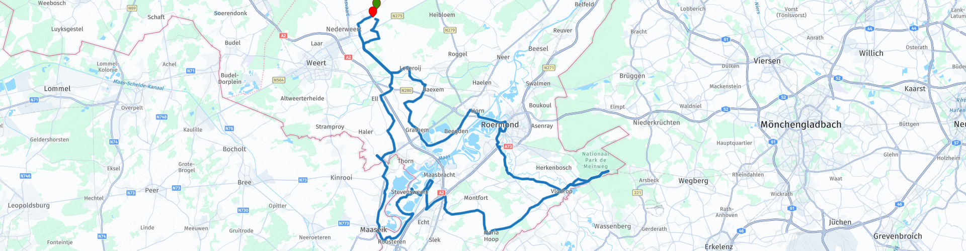
 The 173 ANWB Promoter TankTasTochten (TTT) were scanned by Henry ten Dam and signed by Leon Stolk in Mapsource and later placed as a Track in a .gpx file. These have been made available with the approval of ANWB Promotor via the website of MrGPS so that everyone can enjoy it. The 1st TTT is from 1992, so the route may be slightly different from the original.
I checked all route points and placed them neatly on the road. Also, if necessary, I have put the start point and end point of the route a bit further apart to avoid navigating directly to the end point and I have added the POI files from the start and end point just like a possible stopping point.
Finally, I created the route for TomTom, Garmin and MyRoute-app Navigation users.
With thanks to Henry, Leon, MrGPS and Promoter.
 Share this route


Animation

Verdict


Duration
3h 26m

Mode of travel
Car or motorcycle

Distance
133.47 km

Countries


 RouteXpert Review
 * Ospel is a village in the middle of the province of Limburg and is a church village within the municipality Nederweert. Ospel lies between the place Nederweert and Meijel, near the National Park De Groote Peel.
At Neeritter you cross the border with Belgium to pass it again at Maaseik, via Roosteren you drive to the fortified town of Stevensweert **.
** Together with Ohé and Laak, Stevensweert forms the "Island in the Meuse", an island formed by two (former) arms of the river Maas. The main stream of the river, to which Stevensweert is located, forms here the natural marking of the border with Belgium and is therefore also called Grensmaas.
Fortress city and fortifications
The original village was converted into a fortified town by the Spaniards during the Eighty Years' War. An earthen embankment with seven bastions and five ravelines was built around Stevensweert. Stevensweert has so far retained its rectangular circumference and geometric street pattern. The original rampart no longer exists. In 2007 a start was made on the reconstruction of a small part of the fortifications on the basis of historical map material of a bastion, raveline and accompanying canal north side of Stevensweert. These are now on display.
After Stevensweert it goes towards National Park Meinweg ***, where there is also a stop at Hotel St. Ludwig.
*** National Park De Meinweg is a national park with a size of approximately 18 km² in the Dutch province of Limburg east of Roermond, municipality Roerdalen. The area is surrounded by Germany on three sides and is part of the German-Dutch Grenspark Maas-Swalm-Nette (Source: Wikipedia).
After the break up to Roermond and the Maasplassen **** and back to the end of this TTT in Ospel.
**** The Maasplassen are artificial lakes on the Meuse in the Limburg Maasland. They are located in both Belgian and Dutch Limburg. Their joint area is about 30 km². The Maasplassen are gravel holes, they were created by the extraction of gravel that occurs due to deposition by the Meuse (Source: Wikipedia).
Along the entire route there are plenty of opportunities to pause at a café or restaurant.
Because I have driven large parts of this route myself, this route gets 4 stars.
Route details:
rp 33 - Lunch opportunity at Hotel St. Ludwig.


 Links
Links  Usage
Usage Want to download this route?
You can download the route for free without MyRoute-app account. To do so, open the route and click 'save as'. Want to edit this route?
No problem, start by opening the route. Follow the tutorial and create your personal MyRoute-app account. After registration, your trial starts automatically.  Disclaimer
Use of this GPS route is at your own expense and risk. The route has been carefully composed and checked by a MyRoute-app accredited RouteXpert for use on TomTom, Garmin and MyRoute-app Navigation.
Changes may nevertheless have occurred due to changed circumstances, road diversions or seasonal closures. We therefore recommend checking each route before use.
Preferably use the route track in your navigation system. More information about the use of MyRoute-app can be found on the website under 'Community' or 'Academy'.