Maastricht Bosfagne Ouren Gemund Maastricht

This route was brought to you by:
RouteXpert Hans van de Ven (Mr.MRA)
Last edit: 25-03-2021
 Route Summary
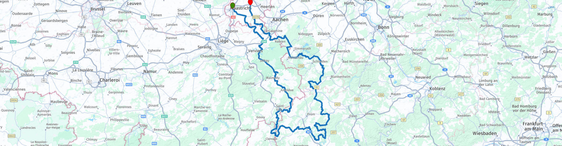
 Motorbike paradise Eifel is just a stone's throw from the Netherlands. You can enjoy curves, rolling landscapes, beautiful villages and romantic castles. You start in Maastricht, and drive south through towns like Slenaken, Heyenrath, Vaals and Moresnet.
 Share this route


Animation

Verdict


Duration
8h 29m

Mode of travel
Car or motorcycle

Distance
435.90 km

Countries


 RouteXpert Review
 The route starts at the McDonalds in Maastricht. We drive to the south where we quickly enter Belgium, via Sippenaeken we drive towards the "High Fens" * where we at Boulangerie Philippe Hennes a delicious sandwich and cup of coffee. Then on to the head of Luxembourg to stretch the legs at Hotel Rittersprung. Then the Eifel in and back to the Netherlands.
* The High Fens (German: Hohes Venn; French: Hautes Fagnes) are part of the High Fens-Eifel Nature Park. The High Fens are located on a plateau, largely in the Ardennes and for a smaller part in the Eifel. It is located in Wallonia in eastern Belgium, there in the province of Liège, and in a piece of adjacent Germany. The whole covers about 4500 ha. As the name implies, a large part of the region consists of deposits of high peat. Some of this is still active, which means that peat formation still occurs. The High Fens have been provided with the European diploma for nature management since 1966. (source: Wikipedia).
The Eifel is the eastern part of the middle plateau Eifel-Ardennes. It lies north of the Moselle and west of the Rhine. The largest part is in Germany, a small part is located in Belgium, in the East Cantons. The German part of Eifel lies in the states of North Rhine-Westphalia and Rhineland-Palatinate. The highest point is the Hohe Acht with 747 meters. In the Tertiary, there was strong volcanic activity in the Eifel. The name Vulkane-Eifel also refers to this in the southeastern part. The craters created by explosions of volcanic gases have filled themselves with groundwater and are called Maare. The last eruptions took place 10,000 years ago. Research shows that this area is still geologically active: the entire Eifel region rises 1 to 2 millimeters per year. In the past, inactive phases of 10,000 to 20,000 years have also occurred, suggesting that future eruptions are still possible. (Source: Wikipedia).
Dutch South Limburg is a region in the south of the Dutch province of Limburg. The area covers an area of 660 km² and has approximately 600,000 inhabitants. South Limburg is characterized by a varied relief and beautiful nature areas in the midst of highly urbanized areas. The most important cities are Maastricht, Heerlen, Sittard and Kerkrade. The area also forms the Safety Region South Limburg (a joint venture between municipalities, fire brigade and medical assistance) (Source: Wikipedia).
Because I have driven this route myself, this route gets 5 stars.
Route details:
The route is created for TomTom, Garmin and MyRoute-app Navigation users.
Take something to eat and drink along the way, then you can always stop to stretch the legs and what to eat and / or drink or to take some pictures.
rp 9 - Boulangerie Philippe Hennes (Coffee and a sandwich)
rp 16 - Hotel-Restaurant Rittersprung
rp 17 - Europa Monument
rp 26 - Photomoment
rp 34 - Gemünder Brauhaus (Schnitzels)
rp 40 - Haus Zahlepohl (Coffee)
rp 48 - Square view Climbing (Ice)


 Links
Links  Usage
Usage Want to download this route?
You can download the route for free without MyRoute-app account. To do so, open the route and click 'save as'. Want to edit this route?
No problem, start by opening the route. Follow the tutorial and create your personal MyRoute-app account. After registration, your trial starts automatically.  Disclaimer
Use of this GPS route is at your own expense and risk. The route has been carefully composed and checked by a MyRoute-app accredited RouteXpert for use on TomTom, Garmin and MyRoute-app Navigation.
Changes may nevertheless have occurred due to changed circumstances, road diversions or seasonal closures. We therefore recommend checking each route before use.
Preferably use the route track in your navigation system. More information about the use of MyRoute-app can be found on the website under 'Community' or 'Academy'.