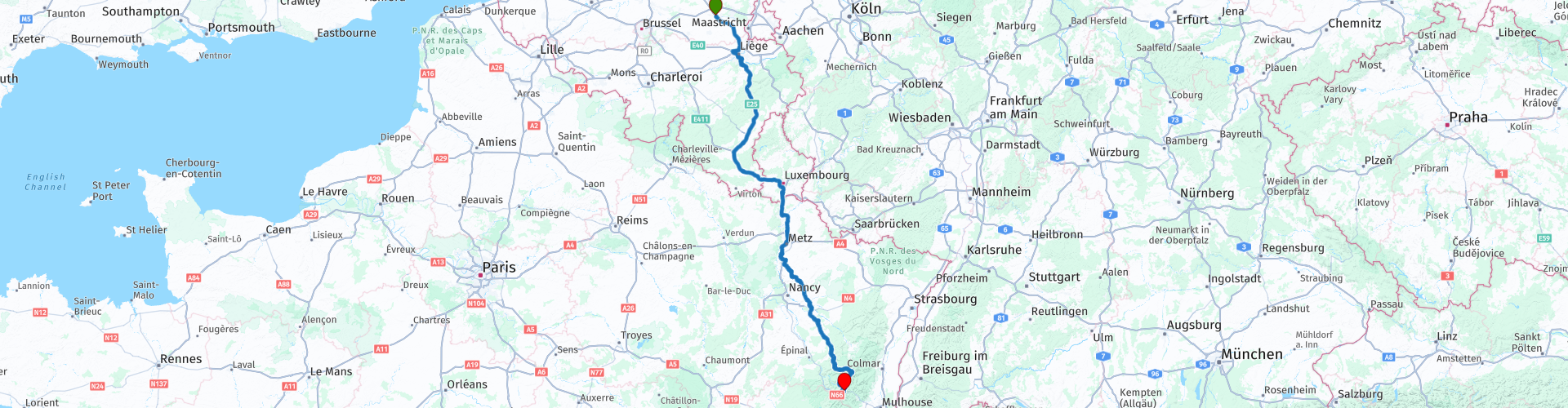
From Hasselt to Col de Bussang via the nature parcs of Ardennes and Lorraine

This route was brought to you by:
RouteXpert Guy Heyns - Adv. RouteXpert
Last edit: 10-12-2024
 Route Summary
 Bussang is located on the southern side of the Vosges and is ideally located to visit all corners of the Vosges. The various rides from the 'Ultimate Collections of the Vosges Mountains' start from Bussang and from the hotel.
There are sufficient places to rest, drink and eat on this approach route to make the 488 kilometer ride bearable for everyone.
Take advantage of the rest and break points and don't forget to stock up on a cheaper stock (gasoline) in Luxembourg!
The route is largely on the highway, so a 5 star rating cannot be given, but it is and remains a fast route over good ground, there are sufficient and decent rest and break points available and, as you approach the goal, the the region is becoming more beautiful and beautiful ....
In addition, the route takes you fairly quickly to where you want to be.
Taking all these things into account, a 4 star rating can still be given, which indicates that it is a very good transit route that can easily be used by anyone as an approach route to the Vosges.
 Share this route


Animation

Verdict


Duration
9h 2m

Mode of travel
Car or motorcycle

Distance
488.75 km

Countries


 RouteXpert Review
 The ridge that remained formed the border between France and Germany from 1871 to 1918. 1918, you read that right. The end of the First World War. Afterwards, boundaries were literally shifted, but you can already imagine that the terrain of the Vosges during WW I was a particularly turbulent area…
This is the approach route that takes you from Hasselt in Belgium to the front door of the Motorhotel du Col de Bussang. It's a typical transit route, so you won't find many tourist stops or points of interest here. Lots of stops. Make use of it so that the route remains palatable for the delicate souls who also want to taste the delicacies of the French Vosges.
The route starts in Hasselt on the immense parking lot of the Carrefour. It is ideally located as a starting point: just next to the highway, it is possible to have breakfast or picnic shopping and the place is large enough to park safely and take the time to greet each other.
The first stretch takes you past Liège. Liege can be very confusing and busy for those who are not used to it. That is why a 'regrouping point' has been set up just after the Liège interchange, should the group have broken up. There is also a refueling facility there, but remember, refueling in Luxembourg is and remains cheaper…
At route point 4 you cross the border with Luxembourg. A little later you 'round' the city of Luxembourg, after which you will soon encounter the 'Aire de Berchem', the last major gas station on the motorway just before the French-Luxembourg border.
We recommend driving past here and taking the next exit after the Aire de Berchem in the direction of rp 5. There you can refuel much cheaper and it is less time to queue.
The route then returns you to the motorway, crosses the Luxembourg-French border (rp6) and descends further south towards Thionville and Metz.
In Metz you cross the Moselle (rp7). A river that you will hear much more about in the 'Vosges Mountains The ultimate collection' route collection. You even visit the (very small) source of this river.
Just past Metz and before the first péage we leave the highway. At rp 8 we take an extended and well-deserved break in 'Auberge De Vezon'. Nice covered terrace and excellent parking; nice in sight.
Now it's only 190 kilometers on normal roads, a nice light drive because we include two more stops, but you are of course free to add more.
You descend further south to have a (coffee) break again at Lunéville. This way it remains easily digestible and the finish is only 120 kilometers away.
At the height of the famous lake of the Vosges (Lac de Gérardmer) we stop for a while to tackle the last kilometers refreshed. From the rest stop at the banks of the Gérardmer it is only an hour to the final destination, Hotel du Col de Bussang.
This hotel was completely renovated in 2022 and is mainly aimed at fellow motorcyclists. Sufficient storage space is provided and the atmosphere is completely motor-oriented, thanks to the owners/operators. Excellent rooms and meals and there is no shortage of like-minded souls. In other words, the atmosphere is always guaranteed…
The route is and remains an approach route in which a section is taken over the highway. As a result, a five-star rating is obviously not feasible, but the road condition in France makes up for it, as do the ever-improving vistas and increasing twists and turns as you approach the Vosges.


 Links
Links  Usage
Usage Want to download this route?
You can download the route for free without MyRoute-app account. To do so, open the route and click 'save as'. Want to edit this route?
No problem, start by opening the route. Follow the tutorial and create your personal MyRoute-app account. After registration, your trial starts automatically.  Disclaimer
Use of this GPS route is at your own expense and risk. The route has been carefully composed and checked by a MyRoute-app accredited RouteXpert for use on TomTom, Garmin and MyRoute-app Navigation.
Changes may nevertheless have occurred due to changed circumstances, road diversions or seasonal closures. We therefore recommend checking each route before use.
Preferably use the route track in your navigation system. More information about the use of MyRoute-app can be found on the website under 'Community' or 'Academy'.

Liège Province
About this region
Liège (French: [ljɛʒ]; Walloon: Lîdje [liːtʃ]; Dutch: Luik [lœyk] (About this soundlisten); German: Lüttich [ˈlʏtɪç] (About this soundlisten)) is the easternmost province of Wallonia and Belgium.
It borders (clockwise from the north) the Dutch province of Limburg, the German states of North Rhine-Westphalia and Rhineland-Palatinate, Diekirch in Luxembourg, the Belgian Walloon (French-speaking) provinces of Luxembourg, Namur and Walloon Brabant and the Belgian Flemish (Dutch-speaking) provinces of Flemish Brabant and Limburg.
Part of the eastern-most area of the province, bordering Germany, is the German-speaking region of Eupen-Malmedy, which became part of Belgium in the aftermath of World War I.
The capital and the largest city of the province is the city of the same name, Liège. The province has an area of 3,857 km2 (1,489 sq mi), and a population of 1,106,992 as of January 2019.[4]
Read more on Wikipedia
It borders (clockwise from the north) the Dutch province of Limburg, the German states of North Rhine-Westphalia and Rhineland-Palatinate, Diekirch in Luxembourg, the Belgian Walloon (French-speaking) provinces of Luxembourg, Namur and Walloon Brabant and the Belgian Flemish (Dutch-speaking) provinces of Flemish Brabant and Limburg.
Part of the eastern-most area of the province, bordering Germany, is the German-speaking region of Eupen-Malmedy, which became part of Belgium in the aftermath of World War I.
The capital and the largest city of the province is the city of the same name, Liège. The province has an area of 3,857 km2 (1,489 sq mi), and a population of 1,106,992 as of January 2019.[4]
View region
 Statistics
  74
74Amount of RX reviews (Liège Province)
 37856
37856Amount of visitors (Liège Province)
 17953
17953Amount of downloads (Liège Province)
 Route Collections in this region
 The 10 most beautiful car and motorcycle routes in Limburg
Limburg, who thinks of Limburg, thinks of flan, coal mines, marl and the hill country. The coal mines have been closed for almost 40 years, the last load of coal was brought up from the Oranje-Nassau coal mine in Heerlen on 31 December and, as they say, South Limburg was transformed from Black to Green and unfortunately there is still little left. view of this period.
But not only pie, marl and coal in Limburg, but also a very beautiful province to tour by car or motorcycle and enjoy all the beauty that the province of Limburg has to offer. For this, the MyRoute app RouteXpert has put together a Top 10 of Car and Motorcycle routes for you.
All routes in this collection have been checked and made equal for TomTom, Garmin and MyRoute-app Navigation by a MyRoute-app RouteXpert.
If you think, I have a very nice route that should certainly not be missing from this collection, send it to:
email: routeexpert@myrouteapp.com
Subject: New Route for the Top 10 collection Province of Limburg composed by Hans van de Ven.
The route will then be reviewed and then added to the Top 10.
To make the Top 10 also the Top 10, 1 route will have to disappear from the Top 10, you can indicate this when submitting the new route.
Have fun with this collection and while driving one of these routes. Enjoy all the beauty that the Netherlands and in particular the province of Limburg has to offer. Click on “View route” to read the review of the chosen route.
I would like to hear your findings about the route(s).
View Route Collection
Top 5 Car and Motorcycle Routes in the Eifel
The Eifel is the eastern part of the medium plateau Eifel-Ardennes. It is located north of the Moselle and west of the Rhine. The largest part is in Germany, a small part is in Belgium, in the East Cantons. The German part of Eifel is located in the federal states of North Rhine-Westphalia and Rhineland-Palatinate. The highest point is the Hohe Acht with 747 meters.
Several chains can be distinguished in the Eifel:
The northernmost part is called the Nordeifel, which in Belgium connects to the High Fens;
To the east of this is the Ahrgebirge, this part is located north of the Ahr in the Ahrweiler district;
South of the Ahr is the Hohe Eifel (or Hocheifel), of which the Hohe Acht (747 m) is the highest point, and also the highest point in the entire Eifel region;
To the west, near the Belgian border, the hills are known as Schneifel, part of the wider Snow Eifel area with peaks reaching up to 698 metres;
South and east of the Hohe Eifel is the Volcano-Eifel, a volcanic area with many crater lakes (Maare).
The southern part of the Eifel is less high. The area is bisected by streams and rivers running southwards. These streams flow into the Moselle. The largest of these rivers is the Kyll; the hills around this river are known as the Kyllwald;
In the south, the Eifel ends in the Voreifel.
In the north of the Eifel there are some large reservoirs. The largest of these is the reservoir in the Roer that was created by the construction of the Roerdal dam.
The Nürburgring is also located in the Eifel, a well-known car circuit for Formula 1 races, among other things. Since 2004, part of the north of the Eifel has become the Eifel National Park. This National Park falls entirely within the German-Belgian nature park High Fens-Eifel. Another part of the Eifel falls within the South Eifel Nature Park.
Well-known throughout the Netherlands and Belgium by car and motorcyclists, so reason enough for the MyRoute app RouteXpert to compile a Top 5 of Car and Motorbike routes for you.
All routes in this collection have been checked and made equal for TomTom, Garmin and MyRoute-app Navigation by a MyRoute-app RouteXpert.
If you think, I have a very nice route that should certainly not be missing from this collection, send it to:
email: routeexpert@myrouteapp.com
Subject: New Route for the Top 5 collection Eifel composed by Hans van de Ven.
The route will then be reviewed and then added to the Top 5. To make the Top 5 also the Top 5, 1 route will have to disappear from the Top 5, you can indicate this when submitting the new route.
Have fun with this collection and while driving one of these routes. Enjoy all the beauty that the Eifel has to offer. Click on “View route” to read the review of the chosen route.
I would like to hear your findings about the route(s).
View Route Collection