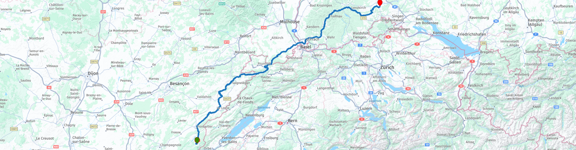
R06 - Metabief to Fuerstenberg

This route was brought to you by:
RouteXpert Arno van Lochem - Senior RX
Last edit: 21-11-2020
 Route Summary
 You will encounter plenty of water, and especially rivers, in this route. About half of the route is on roads built along a river. And roads along rivers in this area are almost equal to bends, many bends and are therefore a pleasure to drive.
Once in Germany, you follow beautiful roads through the Black Forest past Feldberg, among others, before arriving at Fürstenberg, today's final destination.
The route is for the more advanced motorcyclist given the occasional tight hairpin bends. Good engine management is desired!
 Share this route


Animation

Verdict


Duration
5h 16m

Mode of travel
Car or motorcycle

Distance
305.37 km

Countries


 RouteXpert Review
 The start of the route is at Hotel Etoile de Neige in Métabief. After leaving the village, you quickly drive north on the N57. About ten kilometers further you will pass La Cluse-et-Mijoux. Just after this town you will notice that there is a small river on the left side of the road, called Le Doubs (pronunciation Do). This small river, with a length of 430 kilometers, originates in the Jura at an altitude of 937 meters and flows into the Saône, at an altitude of 137 meters.
The name of this river comes from the Latin 'dubius', which means doubter. The source and the mouth are only 100 kilometers apart, yet the river has a length of 430 kilometers. As a result, the river meanders or meanders through the landscape. That someone ever thought of building a road along this river! We come across bend after bend here, the sparse rights sections are badly needed to get the orientation back in order.
Following this Doubs will take you to Morteau. The route leaves this river here. High time to recover from this nice piece of steering! You can do this by visiting 'Le Musée de l'Horlogerie de Morteau', roughly translated as the Morteau Watch Museum.
Morteau has long been an essential city in the watchmaking industry of Franche-Comté. The museum was founded in 1985 under the direction of Constant Vaufrey. Mr Vaufrey, former watchmaker and deputy mayor, wanted to preserve the heritage of Franche-Comté watchmaking and introduce tourists to the history of Morteau.
The museum, spread over two floors and seven exhibition halls, has a very large collection: tools, machines, construction clocks, Comtoise clocks, cartels, pocket watches from all periods and astronomical clocks (from 1855 and 2004) invite the visitor on a journey through the time.
The collections are constantly supplemented with the purchase (gifts, purchases, loans) of new pieces. In 2015, a 1730 Comtoise clock was installed, as well as a 1950s Jaeger-Lecoultre alarm clock.
For information about opening hours and address details, see the link below.
After Monteau, meander further through the French Jura towards today's first stop point, but just before you get there you cross the next river which will follow the route for a while, the Dessoubre. With a length of 33 kilometers, this is a river much shorter than the Doubs, but the meandering is no less.
After 15 kilometers there is a viewing platform, Le Belvedère du baron, which offers you a beautiful view of the area you just drove through. From above you get a very good idea of how the Dessoubre meanders through the landscape and how the road passes it. Well worth a visit, if only for the photo.
After the platform you still meander on the D39 along the Dessoubre until you cross this river at Saint-Hippolyte and reach the D437. Along this road, the Doubs flows again, which we passed earlier. The Doubs still meandering, so the meandering along this river continues unabated. The water is crossed a number of times, so that one time you have the water to your right and the other time to the left.
At the village of Brémoncourt you cross the water again, shortly afterwards you enter Switzerland. The river does not take much notice of French or Swiss territory, it meanders happily, and so does the route. The only thing that has changed is the road sign. That is now the 249, where of course the strict Swiss regulations apply to speeds.
After you drive about ten kilometers in Switzerland you will pass Saint-Ursanne. Saint-Ursanne is an old town in the Swiss canton of Jura, which has retained much of its medieval character. The city contains many historic buildings, including a number of churches, a monastery, many medieval houses and an 18th century bridge, the Doubsbrücken. This bridge is clearly visible from the road that the route crosses.
The town also has three ancient gates. The old center with the sights can only be reached via one of these gates.
Just after Saint-Ursanne, the Doubs is left and you continue the route through Switzerland. Without realizing it, you drive back into France and follow the D432 towards Ferrette, where a stop is planned for lunch.
After lunch, the route takes you north past Basel. When you cross the Rhine you enter Germany. Just after the border, at the town of Schlipf, you will see a small river on the right, the Wiese.
The Wiese is a tributary of the Rhine. It has its source near the Feldberg in the Black Forest at an altitude of about 1200 meters. On its 55-kilometer journey to the mouth of the Rhine near Basel, Switzerland, it flows through the cities of Todtnau, Zell im Wiesental and Lörrach, among others.
This Wiese is also followed for a long time. In some places you lose sight of her for a moment, but further on she is again part of your view.
The Wiese is in view up to Feldberg, a few kilometers before this highest pass in the Black Forest you will pass Todtnau. Close to Todtnau is the mountain called Hasenhorn with a height of 1156 meters. A toboggan run, the Hasenhorn Rödelbahn, has been built against the slopes of this mountain. According to the website, this is the most spectacular toboggan run in Germany. That must of course be tested! Fortunately, you don't have to walk up, because there is a chair lift to take you up.
After Todtnau you cross the Feldberg Pass, with a height of 1231 meters the 'roof of the Black Forest'. On top of this pass you can enjoy a snack on the terrace of hotel Kokoschinski. The terrace of this hotel offers a great view, reason to enjoy a cup of coffee or something else. The non-alcoholic Weizen is also doing very well!
After the Feldberg Pass, the route runs a short distance on the B500, also known as the Schwarzwald-Hochstrasse. After a few kilometers you leave this and continue on the B315, which is also a fantastic beautiful road. The B roads in the Black Forest are characterized by the almost perfect quality of the asphalt.
After a number of villages you will come across the last gas station on this route in Bonndorf. Perhaps not unwise to fill the tank here.
From Bonndorf it is another 25 kilometers to Gasthof zum Rössle in Fürstenberg. A not too big hotel where the Weizenbier of the same name is served, namely Fürstenberg. Tasty beer!
You can choose to eat in the restaurant of Gasthof zum Rössle, but it is recommended to go to the restaurant Wirtschaft zum Bären, where a selection of homemade cakes, snacks or seasonal dishes is waiting for you. Tip: The Eintopf is very tasty and well stocked. The spoon remains upright in it!
The way there is simple: Walk from the hotel towards the church (Kirchstraße), go right in front of the church and follow this road for 1500 meters. Nice walk so just before dinner.
Have fun driving this route!


 Links
Links  Usage
Usage Want to download this route?
You can download the route for free without MyRoute-app account. To do so, open the route and click 'save as'. Want to edit this route?
No problem, start by opening the route. Follow the tutorial and create your personal MyRoute-app account. After registration, your trial starts automatically.  Disclaimer
Use of this GPS route is at your own expense and risk. The route has been carefully composed and checked by a MyRoute-app accredited RouteXpert for use on TomTom, Garmin and MyRoute-app Navigation.
Changes may nevertheless have occurred due to changed circumstances, road diversions or seasonal closures. We therefore recommend checking each route before use.
Preferably use the route track in your navigation system. More information about the use of MyRoute-app can be found on the website under 'Community' or 'Academy'.