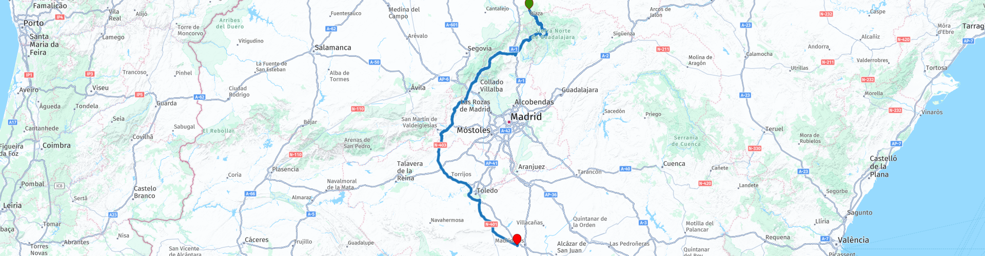
02 Riaza to Consuegra to see the windmills of La Mancha

This route was brought to you by:
RouteXpert Nick Carthew - (MRA Master)
Last edit: 17-04-2025
 Route Summary
 This route will take you on mountain roads, across dams and bridges, through a ski resort, a short section of motorway avoiding Toledo and onto the windmills of La Mancha, made famous in the books by Miguel de Cervantes and his character Don Quixote.
The landscape, scenery and the windmills make this a 5***** star route.
 Share this route


Animation

Verdict


Duration
8h 49m

Mode of travel
Car or motorcycle

Distance
364.51 km

Countries

 RouteXpert Review
 Hard earth, black rock, high mountains and deep ravines. This is the area of the Black Towns or towns with black architecture owing to the local slate used for building. An isolated landscape where amazing corners await for those who are not afraid of narrow roads. There, the road known as the China Wall of Guadalajara zigzags along guarding the Jaramillo River. The road got its name from the stone battlements lining one side of the concrete road giving the entire road the look of a defensive perimeter. The wide unevenness with which each segment of this road twists, resemble the sections of the Great Wall of China. A winding road surrounded by huge stone slabs that seem to be arranged on purpose to make the passage impassable. Always silent, this place seems undeterred, watching for the vultures that fly over it in search of something to eat. The panoramic views are spectacular. Hairpin bends and huge drop offs take you unashamedly to a bridge that looks older than the structure itself. It dates from the last quarter of the last century. Its surroundings offer a place to stop for a photo or to test your vertigo by looking at the river course from the safety of its barrier. Roads like the China Wall are what motorcycle adventures are all about.
14 km on from the end of the China Wall is a small viewpoint just before the village of La Hiruela. From here you can see a group of traditional beehives. The hives, typical of the region, are made with a hollow trunk of oak (or cork), which sit on granite slabs, and are usually closed at the top by means of a board made of cork or nailed wood to then be covered with a slate slab or a piece of clay pot.
Sitting in a privileged position in the Sierra del Rincón, the mountain village of Prádena del Rincón is next and a great place to stop for a coffee. The mountain is a unique place and was declared a Biosphere Reserve by UNESCO in June 2005. If you take a walk around the village, stop for a moment at the Church of Santo Domingo de Silos, one of the oldest in the area (dating from the thirteenth and fifteenth centuries). Or the horseshoeing colt, ancient and genuine, this gives you an idea of the importance that cattle and cowboys had in this municipality.
Just a short ride from the village is the Puentes Viejas reservoir, the third of a chain of five reservoirs of the Lozoya river that supplies Madrid with clean water. The route travels over the Presa de Puentes Viejas (Old Bridges Dam), so called because of the two that once spanned the Lozoya river. The access to the dam is controlled by traffic lights and there is a small area on each side to walk across for photos.
The route also passes the first of the reservoirs. Since its construction in 1967, the Pinilla reservoir, located in the upper course of the Lozoya river has been the top reservoir of the five that control the basin of this river. It was conceived as a quick and affordable solution to the pressing need to increase water supply capacity to the region until the El Atazar and Pedrezuela dams could be completed.
Now you'll head into the Guadarrama mountain range for lunch at Puerto de Navacerrada ski resort, a good place for lunch or coffee and to stretch your legs. The ski resort was one of the first in Spain and opened in the 40s. The chair lifts are open all year round for those that like to hike as well as ski.
After lunch, the route slowly makes it's way down out of the mountains and starts to use some faster roads. These are generally not busy and are fun to use with plenty of corners and the countryside is always a pleasure to be in. It's also noticeable that the landscape is beginning to change to that of a more drier and parched one.
Crossing the River Alberche on the modern concrete bridge gives you good views of the old stone bridge alongside and the San Juan dam a few hundred metres upstream. The reservoir was built in 1955 to supply water to the city of Toledo some 60km away as the crow flies.
The route turns off of the faster road a short distance after the river to use a short, 5km section of smaller road (a little bumpy but worth it) that travels through a beautiful pine forest that scents the air with the aroma of pine forest as you ride along.
A coffee and fuel stop is next and then the route uses 47km of motorways to avoid the busy roads around Toledo. I'm not normally a fan of using motorways, but these travel through the vast plains of central Spain and offer good long distance views as well as the various crops including olive groves. 30 minutes after leaving the motorway and you'll catch sight of the Windmills of La Mancha at Consuegra. Taking advantage of the only hill for miles around the ancient windmills and 12th century Castle of La Muela dominate the skyline.
These windmills became famous in the 17th century, when Don Quixote was first published and introduced the scene of Don Quixote fighting with the windmills. (They must be giants)
The windmills were transmitted from fathers to sons for generations, and eventually stopped being used at the beginning of the 1980s. Each of the restored windmills has a name, these are: Sin nombre, Clavileño, Chispas, Espartero, Rucio, Cardeño, Caballero del verde gabán, Alcancia, Ruinas, Sancho, Mambrino and Bolero.
The windmills usually consisted of two rooms or levels. Millers had to carry sacks of grains that could weigh 60 or 70 kilos to the top floor, they rotated the sails of the windmill into the wind as the top part of the windmill or dome was movable.
There were originally 13 windmills in Consuegra, but only 12 have been reconstructed. These windmills are all located on a small mountain range south of the town, known as Cerro Calderico that also hosts Castle of La Muela.
Four of us rode this tour in May 2019 and chose to stay in an apartment with a garage and a roof terrace that overlooks the windmills. The apartment was called Apartamentos Oncemolinos and was booked through Booking dot com, I have added the link below. It was very comfortable and we chose to cook in the very well appointed kitchen.
There are other choices available nearby as well as restaurants.
Enjoy.


 Links
Links  Usage
Usage Want to download this route?
You can download the route for free without MyRoute-app account. To do so, open the route and click 'save as'. Want to edit this route?
No problem, start by opening the route. Follow the tutorial and create your personal MyRoute-app account. After registration, your trial starts automatically.  Disclaimer
Use of this GPS route is at your own expense and risk. The route has been carefully composed and checked by a MyRoute-app accredited RouteXpert for use on TomTom, Garmin and MyRoute-app Navigation.
Changes may nevertheless have occurred due to changed circumstances, road diversions or seasonal closures. We therefore recommend checking each route before use.
Preferably use the route track in your navigation system. More information about the use of MyRoute-app can be found on the website under 'Community' or 'Academy'.

Castile and León
About this region
Castile and León (UK: , US: ; Spanish: Castilla y León [kasˈtiʎa i leˈon] (listen); Leonese: Castiella y Llión [kasˈtjeʎa i ʎiˈoŋ]; Galician: Castela e León [kasˈtɛlɐ ɪ leˈoŋ]) is an autonomous community in north-western Spain.
It was created in 1983. Formed by the provinces of Ávila, Burgos, León, Palencia, Salamanca, Segovia, Soria, Valladolid and Zamora, it is the largest autonomous community in Spain in terms of area, covering 94,222 km2. It is however sparsely populated, with a population density below 30/km2. While a capital has not been explicitly declared, the seats of the executive and legislative powers are set in Valladolid by law and for all purposes that city (also the most populated municipality) serves as de facto regional capital.
Castile and León is a landlocked region, bordered by Portugal as well as by the Spanish autonomous communities of Galicia, Asturias, Cantabria, the Basque Country, La Rioja, Aragon, Castilla–La Mancha, the Community of Madrid and Extremadura. Chiefly comprising the northern half of the Inner Plateau, it is surrounded by mountain barriers (the Picos de Europa to the North, the Sistema Central to the South and the Sistema Ibérico to the East) and it is drained by the Douro River, flowing west toward the Atlantic Ocean.
The region contains eight World Heritage Sites. UNESCO recognizes the Cortes of León of 1188 as the cradle of worldwide parliamentarism.
Read more on Wikipedia
It was created in 1983. Formed by the provinces of Ávila, Burgos, León, Palencia, Salamanca, Segovia, Soria, Valladolid and Zamora, it is the largest autonomous community in Spain in terms of area, covering 94,222 km2. It is however sparsely populated, with a population density below 30/km2. While a capital has not been explicitly declared, the seats of the executive and legislative powers are set in Valladolid by law and for all purposes that city (also the most populated municipality) serves as de facto regional capital.
Castile and León is a landlocked region, bordered by Portugal as well as by the Spanish autonomous communities of Galicia, Asturias, Cantabria, the Basque Country, La Rioja, Aragon, Castilla–La Mancha, the Community of Madrid and Extremadura. Chiefly comprising the northern half of the Inner Plateau, it is surrounded by mountain barriers (the Picos de Europa to the North, the Sistema Central to the South and the Sistema Ibérico to the East) and it is drained by the Douro River, flowing west toward the Atlantic Ocean.
The region contains eight World Heritage Sites. UNESCO recognizes the Cortes of León of 1188 as the cradle of worldwide parliamentarism.
View region
 Statistics
  38
38Amount of RX reviews (Castile and León)
 13530
13530Amount of visitors (Castile and León)
 3427
3427Amount of downloads (Castile and León)
 Route Collections in this region
 Three tours in and around Picos de Europa Northern Spain
The Picos de Europa is a mountainous area in northern Spain, next to the Basque Country. In the middle is the village of Posada de Valdeon, which cannot be reached by motorbike from the north: you have to drive around the Picos via Potes or Sames. We stayed overnight in Posada de Valdeon in Hostal Casa Abascal. A great hotel with breakfast option. You can eat in a restaurant in the village with usually a choice of two menus.
There are all kinds of nature reserves around the Picos. These three routes take you through some of them. There are gorges to see, viewpoints, reservoirs and you can walk more than fine. If you like walking, bring your walking shoes.
But we come to ride and it's going great. Excellent roads with the occasional piece of unpaved so that you do not have to detour far for another attraction. You can eat delicious food and the people are very nice and hospitable. And because the route to Lourdes goes above the Picos, there are also pilgrimage sites and very beautiful churches and monasteries. The most beautiful thing in this area is the nature: breathtakingly beautiful with wild animals, rugged mountains and wild rivers.
All in all, you can spend at least 4 days here if you take a day of rest or go for a walk.
View Route Collection
Ten Day Roadtrip from Spain to Portugal
This route collection describes a 10-day Road trip in the north of Spain and Portugal, a true paradise for motorcycling.
You drive over beautiful mountain ridges and through beautiful valleys. Along the way you drive through beautiful villages and countless nature reserves, great passes with countless curves, tunnels cut out of the mountains and azure blue reservoirs. The roads are fair to good, sometimes unpaved.
What you get to see along the way;
Spanish Pyrenees
Parc Naturel del Cadi-Moixero
Serra del Cadí
Serra de Moixeró
Pedraforca
Serra del Monsec
Collada de Clarà
Parque Nacional de Ordesa y Monte Perdido
Collados del Asón Natural Park.
Parque natural Saja-Besaya
Parque natural de Fuentes Carrionas y Fuente Cobre
Parque natural de la Montana de Riano y Mampodre
Picos de Europa
El Parque regional Montaña de Riaño y Mampodre
El Parque natural de Redes
The Sierra de la Culebra
Parque natural Montesinho
Along the routes there are more than enough nice places to stop for a short or longer period, these are described in the review and with a waypoint and POI included in the routes.
Have fun reading and planning your next motorcycle vacation.
If you have ridden these routes I would like to hear your feedback.
View Route Collection