Hasta la Vista from Espalion

This route was brought to you by:
RouteXpert Jan Koelstra (jan cabrio)
Last edit: 18-04-2025
 Route Summary
 Routes under this umbrella have in common that they all come closer to the Spanish sun, where along the way you will be reunited with (almost) forgotten impressions and memories.
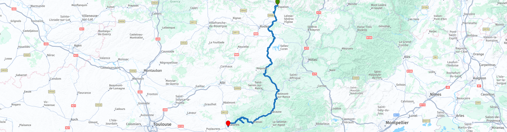
This time the trip goes from Espalion to Castres
The route runs straight south where the Midi-Pyrénées region begins. The natural landscapes in this region are extremely varied.
By the gradual transition to more hours of sunshine, milder winters, less stress, more affordable living. But also honoring the desire for the Mediterranean kitchen, the outdoors, the friendliness and hospitality of the people. Afterwards you have the "deja" feeling back and that is certainly worth 5 stars.
 Share this route


Animation

Verdict


Duration
7h 15m

Mode of travel
Car or motorcycle

Distance
213.13 km

Countries

 RouteXpert Review
 Espalion is a lively village, situated between the two bridges over the Lot. You can see the former tanneries in their characteristic houses, called "calquières", with wooden balconies and stones on which the hides used to be cleaned. The Old Bridge of pink sandstone from the 11th century gives some extra charm to the location. But the surprise comes mainly from the presence of a Musée du Scalphandre. This museum, which seems a bit strange in this wild area of the Lot, shows rare diving suits. This was due to a patented invention for autonomous diving. It was tested in the Lot.
The town of Espalion is dominated by the castle of Calmont d'Olt, which you pass by looking for a petrol station.
Today, the impressive castle is open to visitors. In addition to the guided tours, there are also all kinds of demonstrations, such as an archery demonstration. A visit to the castle Calmont d'Olt is great fun for both young and old. Don't forget to enjoy the beautiful view of the surrounding area during your visit!
Just before the exit to Bozouls you will see a possibility to refuel. Use it, because the refueling possibilities in the following route are very limited.
The village of Bozouls, perched on a cliff edge above a mountain stream, is located in a natural area that can at least be called impressive. A mighty horseshoe-shaped ravine with a diameter of almost 400 metres and a depth of 100 metres can be admired from the terrace on the town square. A dizzying viewpoint!
On the way south you will pass through the foothills of the Causses. There are hardly any large towns to be found here, due to the inhospitable nature of the landscape.
The castle of Montrozier and the old village dominate the valley of the Aveyron. Here you will find the Provincial Archaeological Museum. The whole forms a nice whole. The castle (early 17th century) is privately owned, but can be viewed from the outside. The bridge over the river Aveyron dates from the 15th century.
The elongated Lac de Villefranche-de-Panat is part of a clever power station. The water that falls on the granite plateau of Lévézou and flows unhindered into the Viaur and the Tarn is collected and used by the nearby power stations. The water from the rivers is pumped into the Lac de Paraloup reservoir a little further away, from where it flows through a 10.8 km long steel tunnel to the Alrance power station and the lake. From this lake, tunnels have been dug to the Lac de Saint-Amans, where the water plunges vertically 461 metres down to the Le Pouget power station on the Tarn. All in all, a real spectacle, but unfortunately largely underground.
It is slowly becoming time for coffee. A nice place for this is Brousse-le-Château. It is located at the place where the river Alrance meets the Tarn. The village owes its existence to this strategic location because this is one of the few places where you could cross the rivers. In the second half of the Middle Ages, tolls were levied.
As the name of the village suggests, it has a castle. What is a French village without such an ancient military building! The castle of Brousse-le-Château dates from the beginning of the eleventh century and is still largely intact and is now a museum. In the village itself there is a Gothic bridge over the Alrance, the Vieux Pont. This was built in 1366. In addition to the castle, Brousse-le-Château also has an interesting church. This dates from the fifteenth century and is very robustly built.
Coffee is available at local catering establishments.
In this region of the Causses lies the Parc Naturel Régional du Haut Languedoc, One of the striking features of this Parc are the large flocks of sheep that roam here. The Lacaune sheep is a breed of sheep originating from Lacaune, in the south of France. The sheep are mainly kept for their milk and play an important role in the production of Roquefort cheese. It goes through a green landscape with meadows. What you also see a lot here are so-called Statue-menhirs, stones that were erected in prehistoric times and are still scattered across the landscape today.
Lacaune is a small town at an altitude of about 600 metres. Among other things, you will find a thermal bath, This ancient spa town, actually called Lacaune-les-Bains, is home to many treasures, remarkable sights and traditional know-how that are definitely worth a visit. The Peyro Levado (the largest menhir in Europe), the fountain of Pisseurs, the Calmels Tower and of course the authentic local charcuterie. Lacaune is a feast for the eyes and the taste buds and an essential stop on your journey south. A good choice for lunch here.
After lunch, it is time to enjoy the course. Because nature can continue to take its course and there is little population here, the roads still offer a lot of challenging driving comfort. The narrow and winding roads are pleasant to drive with good asphalt.
Brassac has two beautiful bridges over the Agout and a small castle from the 17th century. In fact, Brassac itself would go unnoticed by visitors if it were not for one important monument in the town: the old bridge over the Agout river. The stone bridge dates from the 12th century and consists of two large and two smaller arches. The bridge itself is paved with cobblestones and has passing places in the walls. The bridge is only accessible to pedestrians. A leaflet, available at the tourist office in the town hall, guides you through the narrow streets on both banks of the Agout. At each stop, you can admire the past and present of this medieval village with the help of various panels.
The village of Ferrières on the north-eastern border of the Sidobre consists of a number of scattered hamlets along the small valley of the Fierralgues. A huge castle dominates the valley of the Agout here. The impressive main building from the 11th and 13th centuries is flanked by three towers. This castle played an important role in the development of Protestantism, because Protestants were given protection here in the 16th century. Later in the 18th century it also served as a state prison and then as a stronghold of the revolutionaries. It is therefore not surprising that it houses the Musée du Protestantisme de la Haut-Languedoc. The Maison du Luzhier, which is also located in this castle, contains a workshop where all kinds of string instruments are made.
Just before Castres, you will pass through the granite massif of Le Sidobre. In the village of Lacrouzette at the Maison du Sidobre, you can go with a guide to explore the area, but you can also go on your own. Millions of years have been needed for the water to seep through and cause erosion, carving out a rocky landscape with Dantesque shapes. Shaking stones, rivers of stones, piles of rocks, stones formed by the rain, greet you at every corner of the path. At Lacrouzette, the Peiro Clavado, the 'nailed stone' forms an enormous monolith on a tiny pedestal. The Chaos de la Resse is undoubtedly the most impressive cairn you will remember. It is a granite scree that has filled in the bed of an ancient river, petrifying its wild course. In the middle of the massif, the intense blue Lac du Merle releases a quantity of brown, humped rocks. An animal sculptor could not have better depicted the outline and head of a goose at the Roc de l'Oise.
Then it is just a short distance to Castres, a place founded by the Romans and later a free trade centre, from which the city profited greatly. The church of Saint-Benoît, once the cathedral of Castres and today the main church of Castres, only dates from the 17th and 18th centuries. The town hall is located in the former episcopal palace, designed in the 17th century by Jules Hardouin-Mansart (the architect of Versailles) and with gardens designed by André Le Nôtre (the designer of the gardens of Versailles). The Romanesque tower next to it (Tour Saint-Benoît) is the only remnant of the former Benedictine abbey. The city has several old private mansions from the 16th and 17th centuries, including the Hôtel de Nayrac, from the Renaissance. Castres also has the famous Goya Museum, founded in 1840, with the largest collection of Spanish paintings in France. In 1954, a Jaurès Museum was also opened in the house where resistance hero and peace activist Jean Jaurès was born in 1859.
The historical centre of this place is particularly nice to visit. The combination of the old, narrow streets and many shops and terraces ensures that you can safely end your day here with a drink.


 Links
Links  Usage
Usage Want to download this route?
You can download the route for free without MyRoute-app account. To do so, open the route and click 'save as'. Want to edit this route?
No problem, start by opening the route. Follow the tutorial and create your personal MyRoute-app account. After registration, your trial starts automatically.  Disclaimer
Use of this GPS route is at your own expense and risk. The route has been carefully composed and checked by a MyRoute-app accredited RouteXpert for use on TomTom, Garmin and MyRoute-app Navigation.
Changes may nevertheless have occurred due to changed circumstances, road diversions or seasonal closures. We therefore recommend checking each route before use.
Preferably use the route track in your navigation system. More information about the use of MyRoute-app can be found on the website under 'Community' or 'Academy'.

Occitanie
About this region
Occitanie (French pronunciation: [ɔksitani] (listen); Occitan: Occitània [utsiˈtanjɔ]; Catalan: Occitània [uksiˈtaniə]), Occitany or Occitania (), is the southernmost administrative region of metropolitan France excluding Corsica, created on 1 January 2016 from the former regions of Languedoc-Roussillon and Midi-Pyrénées. The Council of State approved Occitanie as the new name of the region on 28 September 2016, coming into effect on 30 September 2016.The modern administrative region is named after the larger cultural and historical region of Occitania, which corresponds with the southern third of France. The region Occitanie as it is today covers a territory similar to that ruled by the Counts of Toulouse in the 12th and 13th centuries. The banner of arms of the Counts of Toulouse, known colloquially as the Occitan cross, is used by the modern region and is also a popular cultural symbol. In 2015, Occitanie had a population of 5,839,867.
Read more on Wikipedia
View region
 Statistics
  82
82Amount of RX reviews (Occitanie)
 29021
29021Amount of visitors (Occitanie)
 4080
4080Amount of downloads (Occitanie)
 Route Collections in this region
 25 Magnificent trails in France
This MRA route collection contains 25 beautiful motorcycle routes in different parts of France, such as the Ardennes, the Alsace, Vercors, the Drôme, the Ardèche, Cote d'Azure, Gorges du Verdon, the Ariège, the Dordogne and Brittany.
The routes have been carefully created by Bert Loorbach, who is an enthusiastic motorcyclist himself. He lived in France for a year and a half, during which time he devoted himself to mapping the unknown and beautiful back roads of France especially for motorcyclists.
The routes are bundled in the Motortourgids France part 1 of Kosmos publishing house and now also available in MyRouteApp.
I have taken over the routes in MRA and sometimes adjusted them slightly to make them even more interesting for the motorcyclist.
View Route Collection
24 Magnificent trails in France
It is clear that France is one of the most beautiful and best touring countries. It offers an incredibly varied landscape with good roads and a pleasant climate. It is not for nothing that you see so many motorcyclists there. My previous collection of 25 routes in France (25 Magnificent routes in France) were based on the route descriptions from the Motortourgids France part 1 made by Bert Loorbach.
This collection of 24 routes comes from Motortourgids France part 2. In this collection, a difference has been made between approach routes and motorcycle tours in a certain area. The approach routes can also be used in combination with the routes from Motortourgids France part 1
The routes are sometimes slightly adjusted based on the tips that Bert Loorbach gives in his description, or because of another place to spend the night, or to reach the minimum length of 2 hours for the MRA Library. For each route, the review contains a more detailed description, including options to stay overnight or places of interest along the way, which are also indicated with a POI and if possible with a short description.
Two or more routes have been created for a number of areas, such as for Burgundy, Auvergne, The Alps, Tarn and Cévennes and Nord-Pas de Calais. These routes can be nicely combined in a multi-day trip.
View Route Collection