04 From Carezza al Lago to Lago di Sauris via the Dolomites

This route was brought to you by:
RouteXpert Leonor Orban - Sr. RouteXpert
Last edit: 11-04-2021
 Route Summary
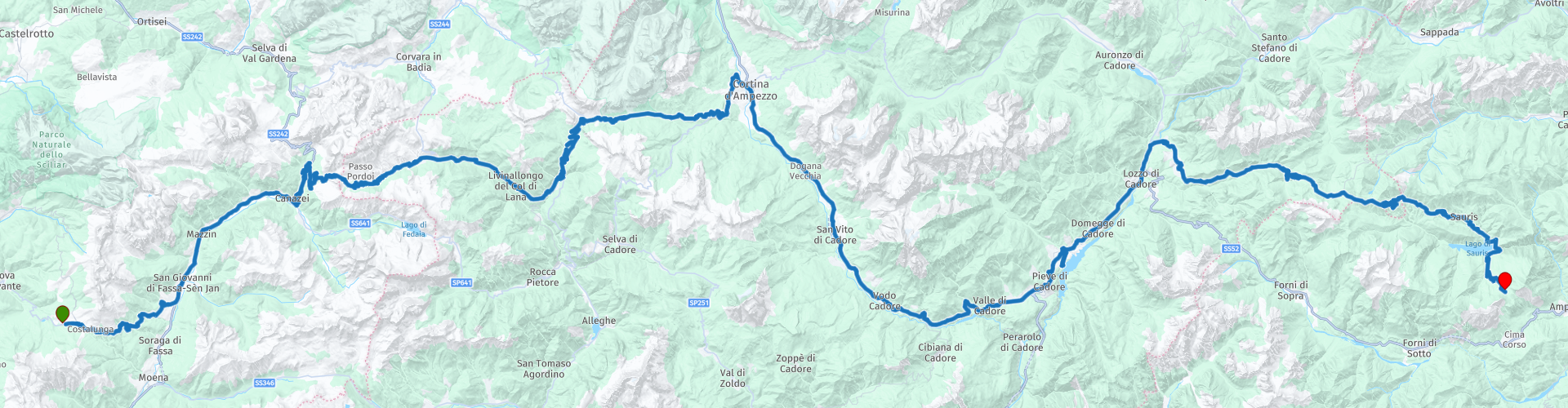
 Today you drive from Carezzo to Lago di Sauris. It is a wonderful ride through one of the most beautiful areas in Northern Italy. It seems a short route with 170 km, but it will definitely be a full-day program with (sometimes narrow) mountain passes and hairpin bends. There is no straight road to be seen today.
The high mountain passes are interspersed with a number of beautiful mountain lakes along the route, where you can take a break and recover from all the bends.
You end the route at Rifugio Alpino Tita Piaz. An attractive mountain hotel, located along the Passo del Pura. In the evening, the view is breathtaking, when the sun sets behind the mountains and it gets really dark.
 Share this route


Animation

Verdict


Duration
4h 14m

Mode of travel
Car or motorcycle

Distance
170.59 km

Countries

 RouteXpert Review
 Hopefully you slept well last night, because the day starts immediately with a wonderfully winding road that demands your full attention: the Karerpass. As soon as you drive out of the village towards the East you can immediately start work. The road winds towards the valley of San Giovanni, where you can refuel if necessary (RP 3).
After a short 45 minute drive, you arrive in the area of the Sella Ronda. Today you only drive the southern part of this famous round: the Passo Pordoi (RP 5). Keep a close eye on which day you want to drive over this mountain pass. In recent years, the Sella Ronda has been closed to motorized traffic on Wednesdays. Before leaving at Hotel Alpenrose, first ask what the status is and whether you can use the pass. If the pass is closed, you can follow the SP641 from RP 4 to Lago / Passo di Fedaia, Col di Rocca and finally Cernadoi. From here you can continue the route.
If the pass is open, it is an absolute must to get off the bike a little earlier than usual. At the highest point of the Passo Pordoi (RP 5) you can park and take the funivia to Sasso Pordoi at 2,950 meters. On top of this mountain top is a Rifugio. It is not without reason that the terrace of this break point is called “the terrace of the Dolomites”: you can enjoy a spectacular view of the Sella Ronda and the surrounding mountains in the Dolomites.
As soon as you pick up the route again, the road winds further to the Northeast. The Passo Pordoi gives you a number of hairpin bends to play and to further sharpen your driving technique. You will catch your breath as you drive through the valley, but from Cernadoi the route shows you again how beautiful driving is in the Dolomites. The area you are in now used to be a busy route for through traffic. Castello Andraz (RP 6) symbolizes this. The castle already existed in the Middle Ages and, together with a number of other castles, controlled and controlled the flow of traffic between Agordina and Val Pusteria. Nowadays your journey is much smoother and the castle can be visited without consequences: at most a small contribution for access to the castle. Keep in mind that in principle you can drive up to the castle and park there (briefly), but the last part of the road is unpaved.
It is time again to conquer some beautiful mountain passes. First you come across the Passo Falzarego. This mountain pass offers stunning views of surrounding mountains such as the Marmolada and Cinque Torri along the way. Don't forget to stop every now and then and take a picture (for example RP 9)! Of course you can take a break on this route. The Locanda Del Cantoniere (RP 8) is a great coffee stop. It is less touristy and less crowded here than at the break points at the highest point of the pass (RP 7).
The Passo Falzarego eventually leads you to Cortina d'Ampezzo, the largest town in the Dolomites and a popular ski resort.
About 50 minutes drive, from Cortina d'Ampezzo, the route leads you to Chalet Lagole at Lago di Cadore (Lake Cadore). Pay attention to this as TomTom and Garmin do not give equal instructions. After you enter the village of Calalzo di Cadore, the route asks you to turn right. Look carefully at the road in front of you and any signs that indicate Lago di Cadore / Chalet Lagole. It is best to follow these signs. Especially if you drive with a TomTom: it indicates a route that will eventually get you stuck. Tip for TomTom: keep left after RP 13 and make sure that all train tracks remain to your right. Eventually you will arrive at the lake and you can enjoy a walk, a swim or a break at Chalet Lagole. It's definitely worth the search!
Eventually you will get to the last part of the route. It is true that you are not a kilometer-eater as a route today, but the roads also make it challenging to cover a great distance. This certainly applies to the last part. At RP 17 (Agip) you can refuel for a while, after which a number of spicy and challenging mountain passes follow. The Sella Ciampigotto, Sella Razzo and Sella Rioda are a quiet alternative to the heavy traffic on the SS52 between Lorenzago di Cadore and Ampezzo. This is because the SS52 is a lot easier to ride than the 3 previously mentioned Sella's. You can enjoy the (hairpin) bends in peace and on the way you can also stop at Lago di Sauris for some photos. The dam at this reservoir was built in World War II by captured New Zealand soldiers. The reservoir behind the dam was finally filled in 1948, after the inhabitants and the church of the village of La Maina moved to higher-lying villages in the area. The remains of the village have been visible twice more in recent decades, after the reservoir was emptied to carry out maintenance work on the dam.
After this photo stop, you will enter a number of narrow tunnels along the reservoir. If all goes well, lighting has been installed in the tunnel in recent years, so that you have (slightly) more visibility. Keep in mind that the road surface in the tunnels can be slippery due to condensation!
Before you arrive at your end point today (Rifugio Alpino Tita Piaz) you drive a part of the Passo del Pura to finish off hopefully a beautiful day. If you really haven't had enough and / or if you arrived early at the end point, you can still drive around in the Sauris region. Val Lumiei is worth it and for the endurists among us: this area is known for a number of beautiful unpaved and accessible mountain passes. For the various options you can visit the website of Alpenrouten. This gives an overview of the various passes (including difficulty, quality road surface, etc.)
Please note that today's route has a number of mountain passes, which may be experienced by some as technically challenging. The three Sella's at the end of the route, including the Passo de l Pura, can be particularly tough. If you have any doubts about your own skills, consider deviating from the route at Lozzo di Cadore and following the SS52 to Ampezzo. There are plenty of accommodation options in this area. From here you can also easily pick up the next day trip and continue the route of the holiday.
This route gets 5 stars from me. It is a beautiful Domolite ride, with not the least of passes. The Karer Pass, Passo Pordoi, Passo Falzarego all pass by (to name a few). From start to finish, enjoy one hairpin after the other. You meander through beautiful valleys, over high peaks. And along the way you can enjoy beautiful break places, such as Chalet Lagole. The views are enchanting and the roads meander endlessly.
Have Fun (with a capital P)!
Note:
Between RP 13 and RP 14 the routes on TomTom and Garmin are not the same. Follow the Garmin instructions on this part. If you only use TomTom navigation: keep left at the y-junction after RP13 and follow the directions for Lago di Cadore. After RP 14 the routes are the same again.


 Links
Links  Usage
Usage Want to download this route?
You can download the route for free without MyRoute-app account. To do so, open the route and click 'save as'. Want to edit this route?
No problem, start by opening the route. Follow the tutorial and create your personal MyRoute-app account. After registration, your trial starts automatically.  Disclaimer
Use of this GPS route is at your own expense and risk. The route has been carefully composed and checked by a MyRoute-app accredited RouteXpert for use on TomTom, Garmin and MyRoute-app Navigation.
Changes may nevertheless have occurred due to changed circumstances, road diversions or seasonal closures. We therefore recommend checking each route before use.
Preferably use the route track in your navigation system. More information about the use of MyRoute-app can be found on the website under 'Community' or 'Academy'.