Roundtrip from Spina along the Parc of the mills

This route was brought to you by:
RouteXpert Catherine De Groote RouteXpert
Last edit: 30-10-2022
 Route Summary
 No motorized traffic is allowed in the historic towns. It is best to park your motorcycle on the edge parking. We received the following tip from the police: if you do not park your motorcycle within the blue-lined parking spaces, you can park for free. At no parking lot was it a problem to place the motorcycle outside the blue markings.
The local roads are in bad condition. Different speed limits apply to this. This varies from 30 km/h to 70 km/h.
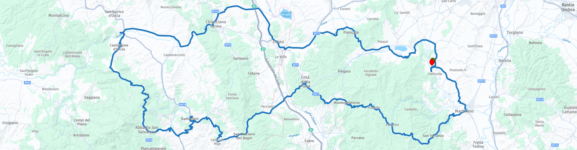
This ride runs partly through Tuscany to, among others, the Parco dei Mulini. But first you can visit the beautiful archaeological museum in Chianciano Terme. You pass the fortresses of Tentennano and Radicofani, which can be seen from afar due to their high location. A last stop is Citta della Pieve which is definitely worth a visit. The winding roads run through the hilly landscape that offers beautiful views. Unfortunately, the secondary roads are not in the best condition. Still, this ride deserves 5 stars.
 Share this route


Animation

Verdict


Duration
11h 41m

Mode of travel
Car or motorcycle

Distance
222.51 km

Countries

 RouteXpert Review
 The first gas station on this ride is in Piegaro after 13 km.
Housed in a former 19th-century granary in the heart of the historic center, the Museo Civico Archeologico delle Acque di Chianciano Terme boasts the world's most important collection of Etruscan canopies or ash vessels in human form.
The exhibition opens with some reconstructions of burials and grave goods, including pottery in bucchero and bronze, figured ceramics and amphorae, dating between the sixth and fifth centuries BC, the period of maximum development of the city.
The collection of canopic jars from the excavations in the vast necropolis of Tolle is very rich. There are also numerous alabaster urns as evidence of the subsequent Hellenistic period. The monumental terracotta pediment that adorned a sacred building in the Astrone Valley, not far from the source of the Fucoli, and dedicated to a beneficent deity, also belongs to the same period. The last part of the museum documents the exploitation of Chianciano's rich resources in Roman times, when luxurious villas and large thermal buildings were built for therapeutic purposes, in which it is said that the poet Horace was also treated.
You drive a bit along the nature reserve Pietraporciana towards Val d'Orcia. The landscape here is open and provides beautiful views.
The Spedaletto Castle was built in the 12th century and was a reception place for 'Rome' travelers and pilgrims. Since 1236, the complex was managed by the Hospital of Santa Maria della Scala in Siena and was called 'Spedale del ponte dell'Orcia'. This position made the 'castle' strategically even more important. It possessed a wealth obtained through various endowments.
The castle has a square plan with towers at each corner, with beautiful stone consoles and battlements all along the perimeter and a beautiful fortified entrance door with a mighty keep for defense. In the first courtyard, immediately to the left of the door, we find the Gothic church of the hospital with a beautiful facade enriched by a rose window. The second entrance door, embellished with stone coats of arms, leads to a second courtyard, the heart of the fortress. The complex is in excellent condition due to recent restoration work. The outside of the castle is free to visit.
A little further you turn to Bagno Vignoni to the Parco dei Mulini. There is a spacious parking lot at the entrance of the village.
Bagno Vignoni is very unique: nowhere else in Italy can you find the main square with a pool filled with hot springs. The Renaissance square, 49 meters long and 29 meters wide, was built directly above the original hot springs. The Etruscans and Romans loved hot springs not only because they were clean, but also because of their medicinal properties. Since the 9th century, the sources are mentioned in ancient travel accounts of abbots and others who made their pilgrimage to Rome (and many to Jerusalem). The hot springs in Bagno Vignoni have always kept water flowing even during the hot summer months, which is why several water mills have been built along the Orcia River over the centuries. These old mills, together with a complex system of water channels and gorges, today make up the Parco dei Mulini, or Park of the Mills, created in the 1990s.
You can follow the springs behind the square and over the cliff past the remains of the old mills and go down as mentioned to the 'Park of the Mills' where you can enjoy the free swimming pools with natural hot water!
Just outside the town you can see the fortress of Tentennano rising on a rocky outcrop. Dating back to the year 850, it was one of the most strategic control points of the Via Francigena for centuries. During the restoration in 1250, the exterior was preserved but little remains of the interior of the fortress.
The road winds further south. Here too you can enjoy beautiful views.
Perched on top of an 896-meter-high basalt spur, Radicofani's castle (or fortress) dominates the town below and the Val d'Orcia. Radicofani and its fortress are part of an artistic, landscape and historical context that runs from the Via Francigena, through the Val d'Orcia Park and the rolling hills of the province of Siena. The tour will lead you to the discovery of the underground tunnels leading to the five bastions, fully lit and open to visitors, and to the keep (old fortress) with its tower, which houses the historical museum, spread over three floors. The archaeological finds of the museum come from a late Bronze Age settlement (12th-10th century BC) located near Radicofani. Continuing the climb, we reach the terrace of the battlements, almost 1000 meters above sea level. This is the highest point in the entire Val d'Orcia, offering a 360° view of the surrounding landscape.
San Casciano dei Bagni is a special village in the southern part of Tuscany. San Casciano dei Bagni is known as a spa town. Tourists from all over the world come to the village to indulge in the healing water. There are more than forty different natural hot springs in the region. They are rich in sulfur and some say they have a healing effect. There are a few spas near the village where you can give yourself a complete pampering day. If you prefer not to spend money but still enjoy the sulphur-rich water, you can visit one of the old Roman baths. The baths have a constant temperature of 42 degrees Celsius.
You can take a break in Bar Sport in Ponticelli for a nice coffee or soft drink, an ice cream or pastry.
At a height of more than five hundred meters above the Valdichiana in Umbria, a beautiful brick town rises that exerts an irresistible attraction for anyone who loves picturesque alleys, surprising vistas and colorful frescoes. If you look at the map of Città della Pieve, you see that the city resembles an eagle, which seems to lunge menacingly to the south. Città della Pieve is divided into three neighbourhoods, called terzieri, which more or less correspond to three different social classes.
The eagle's head corresponds to the Castello district where the knights lived, while the belly is formed by the Borgo Dentro district, where the wealthy bourgeoisie reside. Together, the wing and tail cover the territory of the Casalino district, home to the petty bourgeoisie and craftsmen. In each district, the buildings are mainly constructed of red brick. This type of stone is typical for Città della Pieve, because the stones are excavated and baked here. It creates a warm atmosphere in the narrow streets. It's almost a maze, with a new surprise on every corner: waving wax, a small statue of Mary, a vintage Vespa, a staircase with pots full of colorful flowers… Città della Pieve is known for the production of saffron. In the Middle Ages, this was one of the most important export products. It was used not only in the kitchens of the wealthy families, but also in the workshops of painters, as a natural dye, and for coloring silk and other fabrics.
The Palazzo della Corgna does not immediately look like a gem from the outside, but once you step over the threshold, you will discover beautiful frescoes by Pomarancio and Salvio Savini, doors painted in detail and authentic floors. The wedding hall, where many Dutch bridal couples have already said yes, seems to come straight out of a fairy tale. The perfect setting for an Italian wedding. The Palazzo della Corgna is the main noble house of Città della Pieve. It is currently owned by the municipality. Both the building structure and the decoration have been restored.
The sanctuary of the Madonna di Fatima is the pride of Città della Pieve. This is the first Italian shrine dedicated to Our Lady of Fatima. The complex of the former church of San Francesco is located just outside Porta Perugina, at the beginning of the ancient Via Pievaiola. It is, in fact, the only original part remaining after its destruction in 1766. Even the monastery was extensively renovated in those years and afterwards, between 1845 and 1860. The Church of San Francesco was transformed into the Italian sanctuary of the Madonna di Fatima after World War II.
The co-cathedral of Saints Gervasio and Protasio has a very ancient history. The primitive construction dates from the 4th-5th century, was replaced by a Romanesque building in the 8th century, which in turn was renovated in the 13th century in the Gothic style. Only a few traces of these old interventions remain in the present church, which dates from the 16th-17th century. The side chapels and the bell tower next to the building belong to this period. From the outside this church looks somewhat austere, but inside you will be surprised by a majestic ship. Works by artist Pietro Perugino can be admired in this church. The cathedral has a Latin cross plan and there are no fewer than six chapels. On the altar you can also see a work by Perugino depicting the Mary and the patron saints of Città della Pieve. The construction of the crypt under the main altar dates back to the Gothic period and is built on the remains of earlier civil buildings from the Etruscan-Roman era.
In Marsciano you can fill up the engine. This is the last gas station before you reach the holiday home, after a well-filled but beautiful trip through Umbria and Tuscany.


 Links
Links  Usage
Usage Want to download this route?
You can download the route for free without MyRoute-app account. To do so, open the route and click 'save as'. Want to edit this route?
No problem, start by opening the route. Follow the tutorial and create your personal MyRoute-app account. After registration, your trial starts automatically.  Disclaimer
Use of this GPS route is at your own expense and risk. The route has been carefully composed and checked by a MyRoute-app accredited RouteXpert for use on TomTom, Garmin and MyRoute-app Navigation.
Changes may nevertheless have occurred due to changed circumstances, road diversions or seasonal closures. We therefore recommend checking each route before use.
Preferably use the route track in your navigation system. More information about the use of MyRoute-app can be found on the website under 'Community' or 'Academy'.

Umbria
About this region
Umbria ( UM-bree-ə, Italian: [ˈumbrja]) is a region of central Italy. It includes Lake Trasimeno and Marmore Falls, and is crossed by the River Tiber. It is the only landlocked region on the Apennine Peninsula. The regional capital is Perugia.
The region is characterized by hills, mountains, valleys and historical towns such as the university centre of Perugia, Assisi, a World Heritage Site associated with St. Francis of Assisi, Terni, Norcia, Città di Castello, Gubbio, Spoleto, Orvieto, Todi, Castiglione del Lago, Narni, Amelia, Spello and other small cities.
Read more on Wikipedia
The region is characterized by hills, mountains, valleys and historical towns such as the university centre of Perugia, Assisi, a World Heritage Site associated with St. Francis of Assisi, Terni, Norcia, Città di Castello, Gubbio, Spoleto, Orvieto, Todi, Castiglione del Lago, Narni, Amelia, Spello and other small cities.
View region
 Statistics
  9
9Amount of RX reviews (Umbria)
 12211
12211Amount of visitors (Umbria)
 251
251Amount of downloads (Umbria)
 Route Collections in this region
 8 tours in the Umbria holiday region
Umbria is a region with green, gently rolling hills, mainly covered with vineyards and olive groves, but there are also many fields of wheat, sugar beet, tobacco and sunflowers. This region is also called the green heart of Italy, has a mild Mediterranean climate so that the summers are dry and sunny. Umbria is characterized by ancient walled hill towns with steep streets that bear witness to a rich cultural history. Be pleasantly surprised by this region, where culture and nature are in perfect balance.
Highlights of Umbria are undoubtedly Assisi, Spoleto, Orvieto, Perugia, Gubbio, Todi, Cortona, Umbertide. There are also numerous fortresses in the region such as Montefiascone, Tentennano, Radicofani, Rocca del Leone and Gualdo Cattaneo, which can be seen from afar due to their high location. Civita di Bagnoregio is one of the most beautiful villages in Italy and the parks of Monte Subasi and Monte Cucco offer fantastic views of the beautiful surroundings. Very nice to drive along is Lake Trasimeno, the fourth largest lake in Italy.
Highlights of Umbria are undoubtedly Assisi, Spoleto, Orvieto, Perugia, Gubbio, Todi, Cortona, Umbertide. There are also numerous fortresses in the region such as Montefiascone, Tentennano, Radicofani, Rocca del Leone and Gualdo Cattaneo, which can be seen from afar due to their high location. Civita di Bagnoregio is one of the most beautiful villages in Italy and the parks of Monte Subasi and Monte Cucco offer fantastic views of the beautiful surroundings. Very nice to drive along is Lake Trasimeno, the fourth largest lake in Italy.
View Route Collection