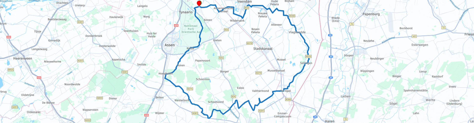
TTT 2020 04 Rondje Drenthe vanuit Zuidlaren

This route was brought to you by:
RouteXpert Hans van de Ven (Mr.MRA)
Last edit: 16-08-2021
 Route Summary
 These TTT are tours through the Netherlands with an occasional trip to Belgium, Germany or even Luxembourg, which are held 6 to 7 times a year. The 1st around March and the last around October. These TTT have a starting point, a pause point and an end point. It is nice to discover what you have not seen in your own country and what nice roads you did not know.
This TTT may differ slightly from the original.
I have checked all route points and placed them neatly on the road where necessary. Also, if necessary, I set the starting point and end point of the route a little further apart to avoid navigating directly to the end point and added the POI files of the start and end point as well as possible pause point (s).
Finally, I made the route the same for TomTom, Garmin and MRA Navigation users.
Thanks to Promotor.
Pay attention! Due to the stricter measures due to the Corona crisis, you may need to reserve a plate on the terrace, so bring some food and drinks with you on the way.
 Share this route


Animation

Verdict


Duration
3h 24m

Mode of travel
Car or motorcycle

Distance
153.09 km

Countries

 RouteXpert Review
 Drenthe flat, bare straight roads a ride, through the peat colonies, Let yourself be surprised! Well, straight roads and barren distances mean you can sit on top of it now and then… up the Hondsrug and nothing barren - oak forests and dolmens and villages that you thought no longer existed. And no, I don't mean Orvelte, that's more of a museum. By the way, those peat colonial settlements with their canal in the middle and alongside neat houses like Annerveenschekanaal and Veendam and the Pekelas also grab my throat. The simplicity of those places, their clear set-up, the security they offer, in the middle of the empty land - call it shabby.
At one point I would advise you to deviate from the route and that is near Grolloo. A little motorcyclist knows that there is the museum of the best Dutch pop music has ever produced and that is the blues band Cuby & the Blizzards. The uncompromising Things I Remember, Crying Tears on which he plays the back of his tongue, that beautiful tune from Somebody Will Know Someday… Cuby will grab you by the throat!
You start this tour in Zuidlaren, accessible via the A28 and then on the N34, renamed Hunebed Highway in 2018 because the whole world naturally wants to discover the Hondsrug Unesco Global Geopark. Zuidlaren stands for wealth under the oaks, with a large Brink and spacious buildings in the green - it is clear that the largest horse market in Europe does not harm the village. Immediately outside the village you enter the Nieuwe Dijk, a kind of launch into space because in front of you are fifty straight kilometers through a completely tightened agricultural area - it is really important that you do not turn yourself over.
In order not to be home before noon, it is best to take the gas off and, for example, take a look at Annerveenschekanaal. Not much, but wait, those people do live in freestanding painters' houses, with front and back gardens, on a canal in the shade of tall trees, in the middle of the vast land - it has something familiar, something safe. More such places will follow later - Wildervank and Veendam and the Pekelas and they are among the most beautiful that the bogging of the Bourtanger Swamp has yielded.
The funny thing is that life in the peat colonies, because that's where you are now, has long been synonymous with a life in extreme poverty. But that's only part of the story. In the nineteenth century, workers in the peat made a decent living, at least better than ordinary farm workers. Only when the coal came up and especially after the First World War did things go wrong and that idea dates from that time.
After even more flat and barren and empty land, Oude Pekela has something new to offer - the Westerwolde region, slightly higher sandy soils where the peat moor has fewer opportunities and people can settle more easily. Everything suddenly looks different, smaller, more intimate, with winding roads along hamlets such as Wedde and Ter Wupping and Oud Veele - never heard of, but witness the old Romanesque churches they have been around for a long time. Then it goes over the Lammerweg and the Leemdobben in the direction of Sellingen - nice steering here, from left to right and from right to left, through well-followed bends and with trees on one side only. And meanwhile wail on the board radio Cuby: 'I beg you baby, please, don't leave me' and 'Have you ever been mistreated, then you know what I'm talking about'.
Behind Ter Apel there is another piece of unadulterated peat colonial pastime, popping six kilometers over the Valtherdijk. And from the Exloërweg, against the Hondsrug, you can enjoy the view - even if the lateral moraine is no higher than twenty meters, it is still enough for a beautiful view of the plain below. But after that the peat colonies are over and you dive into the forests near Odoorn, the Hondsrug Unesco Global Geopark, so to speak.
Because I have not (yet) driven this route, this route gets 3 stars.


 Links
Links  Usage
Usage Want to download this route?
You can download the route for free without MyRoute-app account. To do so, open the route and click 'save as'. Want to edit this route?
No problem, start by opening the route. Follow the tutorial and create your personal MyRoute-app account. After registration, your trial starts automatically.  Disclaimer
Use of this GPS route is at your own expense and risk. The route has been carefully composed and checked by a MyRoute-app accredited RouteXpert for use on TomTom, Garmin and MyRoute-app Navigation.
Changes may nevertheless have occurred due to changed circumstances, road diversions or seasonal closures. We therefore recommend checking each route before use.
Preferably use the route track in your navigation system. More information about the use of MyRoute-app can be found on the website under 'Community' or 'Academy'.