08 Mokau to Wanganui via Mt Taranaki volcano

This route was brought to you by:
RouteXpert Nick Carthew - (MRA Master)
Last edit: 03-02-2021
 Route Summary
 The thrill of riding up a volcano and the beautiful landscapes is why I have awarded 4**** stars for this route.
 Share this route


Animation

Verdict


Duration
5h 47m

Mode of travel
Car or motorcycle

Distance
266.61 km

Countries

 RouteXpert Review
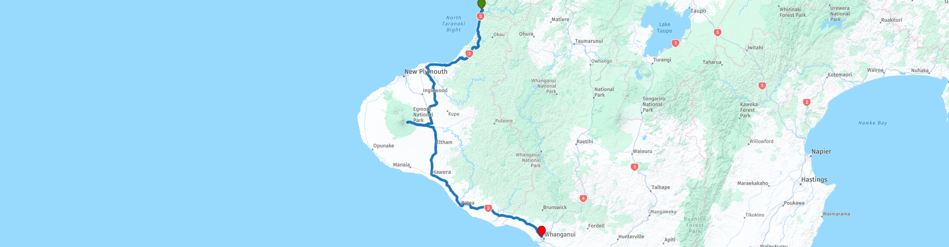
 Leaving from Mokau, the route uses the State Highway 3 to follow the coast of the North Taranaki Bight offering coastal views along the way. The peak of Mount Taranaki often appears in your view as you travel south.
At RP 6 you get a glimpse of the rock formations on the beach known as Elephant Rock and the Three Sisters. You can see two (formerly three) 25 metre rock formations known as the Three Sisters. Another spectacular formation called Elephant Rock once stood alongside the sisters, before losing its trunk to erosion in 2016. Interestingly, there were four sisters at the turn of the century, but the sea is claiming them one at a time.
The SH3 takes you inland briefly to navigate around the east of Mt Messenger. You'll pass through your first New Zealand tunnel, carved through the rock in 1916. It's only short but the road's elevated position among the treetops make it a pleasing experience riding through. When it was first opened it had a sharp gothic arch and was single track adding to the experience, sadly the elegant arch was lost around 1990, when the tunnel was enlarged to provide two-lane access. Mt Messenger is named after Colonel William Messenger, the commander of the garrison at nearby Pukearuhe redoubt during the 1870s and 1880s. The road descending from the tunnel has some nice bends as it makes its way back to the coast.
Just after RP 10 that marks the Waitara River, the route leaves SH3 to avoid the major city of New Plymouth. It is named after the English city of Plymouth, Devon from where the first English settlers to New Zealand migrated. If you prefer, you can remain on the SH3 to visit New Plymouth and then take the SH3 out of the city to Inglewood and pick up the route again at RP 14. I have suggested a coffee stop at RP 15 in Midhurst at the Midhurst Tavern. From here you'll start the climb up the slopes of Mt Taranaki. It is worth remembering that the climb to the viewpoint up Mt Taranaki at 1157 m may be cooler, so add an extra layer of warm clothing.
There are some breathtaking views of the often snow capped peak as you get closer and closer and a good place for a photo can be found near RP 16. Dense woodland marks the boundary of the Egmont National Park that surrounds New Zealand's most perfectly formed volcano. For those interested in botany, Egmont National Park makes it possible to observe the progression of plant species from surf to summit. The lowland forest is scattered with rimu and rata trees, which gradually make way for kamahi, totara and kaikawaka. The 'Goblin Forest', on the mountain's middle slopes, takes its name from the gnarled shape of the trees and the thick swathes of trailing moss. Above the forest you'll find sub-alpine scrub and alpine herbs.
In 1881, a cartographer put his compass point on the mountain's paper peak, drew a circle with a 9.6 km radius and bingo, Egmont National Park was born. Now, 134 years later, intensely farmed and brilliantly green dairy pasture butts up to the mostly circular park boundary and, on the other side of the fence, magnificent old-growth forest looms. The circle of green is so clear, it is visible from space as you can see from the picture below.
Often described as ‘New Zealand’s most climbed mountain’, Mt Taranaki or Mt Egmont as it is sometimes known, provides non-mountaineers with an achievable summit challenge. From the Stratford Plateau car park at RP 18, it would take at least 8 hours to reach and then return from the summit, so perhaps just enjoy the views from the carpark at 1157 m. From December to April, fit and well-equipped trampers can enjoy spectacular scenery from the summit of Mt Taranaki. From May to November, the mountain is covered in snow and ice - mountaineering experience and equipment is required.
Taranaki is the original name given by the indigenous Māori people, while the name Mt Egmont was given by British explorer James Cook. In 1770, Captain James Cook sailed past the mountain and named it Egmont. This was to honour John Perceval, the Second Earl of Egmont, First Lord of the Admiralty, and a key supporter of Cook’s voyage. Cook didn’t land in the region so the local people weren’t informed about the name change. Poor old Perceval died before he ever found out!
As you come back down off of the volcano, I have suggested a fuel stop in Stratford, there are cafes and restaurant should you wish to stop here for lunch or there are fast food restaurants 25 mins away at RP 22 in Hawera. You can also choose to turn right in Stratford to visit Dawson Falls. Dawson Falls is a scenic 30 minute drive from Stratford up the side of the volcano again. Dawson Falls itself is an 18 metre high waterfall named after Thomas Dawson, the first European to discover the falls in 1885. There is also a visitors centre and cafe there.
From Stratford the SH3 takes you through open farmland to Hawera and as previously mentioned there are McDonalds, KFC etc for a lunch break. The end of this route at Wanganui is 1 hours ride from here.
Wanganui is a place steeped in history, art and culture. Big enough to draw crowds and small enough to be intimate. Architecture from many eras is a major feature of Wanganui. Victorian and Edwardian treasures co-exist with fine examples of mid-twentieth century modern architecture. Marae, homesteads, memorials and civic buildings provide a strong sense of place and identity and the concentration of significant heritage buildings found here is rare in New Zealand.
There are many choices for accommodation from camping to classy hotels. I have suggested a few below in the links. This route ends at BKs Magnolia Motor Lodge, a mid priced motel with off street parking.
Enjoy.


 Links
Links  Usage
Usage Want to download this route?
You can download the route for free without MyRoute-app account. To do so, open the route and click 'save as'. Want to edit this route?
No problem, start by opening the route. Follow the tutorial and create your personal MyRoute-app account. After registration, your trial starts automatically.  Disclaimer
Use of this GPS route is at your own expense and risk. The route has been carefully composed and checked by a MyRoute-app accredited RouteXpert for use on TomTom, Garmin and MyRoute-app Navigation.
Changes may nevertheless have occurred due to changed circumstances, road diversions or seasonal closures. We therefore recommend checking each route before use.
Preferably use the route track in your navigation system. More information about the use of MyRoute-app can be found on the website under 'Community' or 'Academy'.