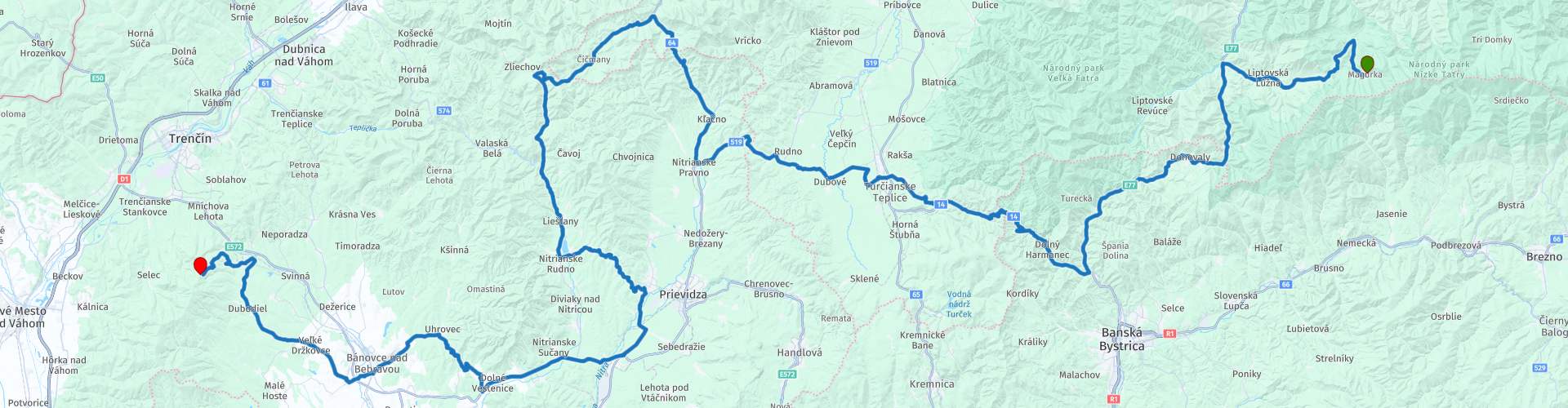
08 From Magurka to Trencianske Jastrabia via Velka Fatra and Bojnice

This route was brought to you by:
RouteXpert Leonor Orban - Sr. RouteXpert
Last edit: 31-12-2021
 Route Summary
 It's an easy ride to drive. A large part of the route is on well-paved main roads. If you want a little more excitement and adventure, you will find two marked spots along the way where you can deviate from the original route to take a dirt road over a mountain pass or through a forest.
Of course you will also find a number of special cultural sights along the route, such as the most famous (ghost) castle in Slovakia (Hrad Bojnice), the village of Čičmany and an impressive war memorial (Pamatnik SNP).
The route gets a score of 4 points. Nature is beautiful, the range of cultural attractions is diverse and there are plenty of stops along the way where you can taste delicious local dishes!
 Share this route


Animation

Verdict


Duration
7h 51m

Mode of travel
Car or motorcycle

Distance
223.98 km

Countries

 RouteXpert Review
 The morning starts quietly… Literally and figuratively. Magurka chata is located in the middle of the Low Tatras, in a small hamlet. Take the time to absorb the silence outside in the morning. And because the route is not too long, you can take plenty of time before your departure. While enjoying a cup of coffee, discuss whether you would like to ride some unpaved trails today… And then the ride can begin.
First of all you drive the small road back towards the main road. This time, turn left to continue westward over the Prievalec pass. You slowly ascend to a modest altitude of 1,100 meters before entering the town of Liptovská Osada. Here you can refuel. If you like to drive unpaved, there is a nice alternative to consider. The next part of the route (until just before Uľanka) is a through road. Fine to drive if you want to start the day calmly, but perhaps too boring if you are looking for a little adventure. Do you want the latter? Then, from Liptovská Osada, follow the signs to the village of Vyšná Revúca and follow the POIs, which will lead you on road 2223. This route takes you over the unpaved Veľký Šturec mountain pass. Through a number of hairpin bends you are led over the mountain ridge. Eventually you will find a connection to the paved road at the bottom of the mountain, which is part of the route.
The unpaved pass, and the next part of the route, goes through the Veľká Fatra National Park. This protected nature reserve is part of the Carpathians and is known for the diversity of wild animals. How nice would it be to encounter a bear or lynx on one of your last days of travel through Slovakia!
Even before you leave the forested mountains of the Veľká Fatra, you can take a break at restaurant Čierna Ovca. You will arrive here after about 1.5 hours of driving. Maybe a little early for lunch time, but if you're hungry, consider eating here. The restaurant serves delicious local specialities.
Make sure you don't get an after-lunch dip after this stop: right after the restaurant, the first 10 kilometers demand all your attention. The curves of the Malý Šturec seem endless. You haven't passed one yet or you have to concentrate on the next bend! With a big grin from ear to ear you drive into the valley of Turčianske Teplice.
In a short time you have left the bustle of this town behind you and you can, if you want, look for a second unpaved de-tour. A compact gravel road dives into a small forest area, around which the original route goes. The path leads wonderfully through the tall trees, before finally returning to the route over a sandy path between the fields.
The next part of the route takes you via a winding main road to Nitrianske Pravno. Even after this town, the road is wonderfully sloping. The view alternates between open views of the rolling hills and dense forests.
You will find yourself slowly but steadily rising again. The route climbs towards the peaks of the Strážov Mountains. The mountains are part of a protected nature reserve, which covers an area of approximately 250 km2. And of that, about 75% is again covered by forests. Along the way you will also notice that you will have few views thanks to the densely wooded area.
Fortunately, the sight breaks open again after a while, just before the village of Čičmany. Take the time to walk and look around this village. The village is known for its beautiful wooden houses with white decorations on the woodwork. In the past, the women in the village would paint white patterns on the wood to protect it from UV rays. These patterns create a special image in the village. The two most beautiful wooden houses (Radenov Dom and Gregorov Dom) have been turned into museums, so you can discover more about the local folklore and history of this region.
Actually, today is simply another easy route. The next part slides gently down the mountain, towards the South. The roads are generally of good quality and the view is slowly opening up again now that you leave the forest area of the Strážov Mountains behind you. Along the way you can stop for a quick photo of the Nitrianske Rudno reservoir and not too long after that you enter the town of Bojnice.
Time to take another short break and walk if you feel like it. The town of Bojnice is best known for the Bojnice castle of the same name. The castle's history dates back to the 12th century and has had influential residents, including Matthias Corvinus (1443 - 1490). He is considered one of the most glorious rulers of Hungary. Another equally famous resident was the “Black Lady”. Together with her husband, the lord of the manor, they were a happy and successful couple. The lord was a military leader, she was known for her virtue and compassion. After some relatives stayed over, they soon became jealous of the happy couple.
So they told the lord that while he was in a war, his wife was having fun with other knights. He was furious and devised a simple test of her virtue. The Black Lady had to jump with their newborn son from the highest tower of the castle into the moat. If she were to live, surely she must be innocent.
The Black Lady jumped with her son without hesitation, because she knew she was innocent. Before they touched the water, they suddenly floated up and away, proving their innocence. The jealous relatives dissolved in a cloud of smoke. Her husband, ashamed of his mistake, left for a monastery. Lonely and alone, the Black Lady languished in sorrow in the castle. Since then, visitors to the castle regularly hear howls and screams in the castle's corridors and towers. It is so haunted that you can get a guided tour at night and an annual ghost festival is held, in honor of the many sightings of ghosts. The shivers run down your spine!
Another place that can give you the shivers is further up the route: Pamätník SNP – Jankov Vŕšok. On top of the hill you will find an impressive memorial to a military brigade who fell on this hill after the bunkers were stormed by German Nazi troops. The original Partisan bunkers, weapons and other objects from that time can be viewed there. It will also become clear why a group of soldiers was stationed here: the view of the surrounding area is beautiful.
From here it is only 40 kilometers to the end of the route. On the way you can refuel in Bánovce nad Bebravou, after which you will be guided via the main road to Trenčianske Jastrabie. Up to this town the asphalt is fine. The last stretch to the hotel gets a bit worse. Keep in mind that you drive up a narrow mountain path. The road is asphalted, but here and there there are some deep holes in the asphalt. The trip uphill towards Inovecká chata is definitely worth it! The road sign with the text “stress and arrogance prohibited” says it all. ????


 Links
Links  Usage
Usage Want to download this route?
You can download the route for free without MyRoute-app account. To do so, open the route and click 'save as'. Want to edit this route?
No problem, start by opening the route. Follow the tutorial and create your personal MyRoute-app account. After registration, your trial starts automatically.  Disclaimer
Use of this GPS route is at your own expense and risk. The route has been carefully composed and checked by a MyRoute-app accredited RouteXpert for use on TomTom, Garmin and MyRoute-app Navigation.
Changes may nevertheless have occurred due to changed circumstances, road diversions or seasonal closures. We therefore recommend checking each route before use.
Preferably use the route track in your navigation system. More information about the use of MyRoute-app can be found on the website under 'Community' or 'Academy'.