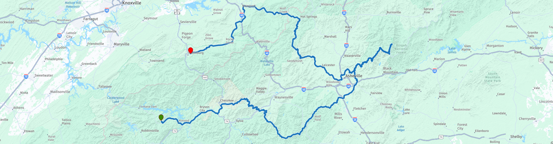
Day 5 Stecoah the Blue Ridge Parkway Gatlinburg

This route was brought to you by:
RouteXpert René Plücken (MRA Master)
Last edit: 12-02-2021
 Route Summary
 America is pre-eminently a country to explore on a motorcycle. There are many travel organizations that offer organized tours, but the charm is also to map out routes and drive on your own.
Good motorbike rental companies can be found throughout the country and the bikes are often of the latest model and well maintained.
We drive on the beautiful roads in the states of Nashville and North Carolina and this area is characterized by the beautiful idyllic landscape with provincial two-lane roads that wind through the landscape with many curves, you can visit beautiful towns, villages and places of interest.
Be careful though, because the roads are sometimes of very poor quality and hardly or not lit up in the dark.
For each route there is a more detailed description in the review.
The route is suitable for TomTom, Garmin, Harley-Davidson BoomBox 2 (2019 model) and MyRoute-app Navigation.
 Share this route


Animation

Verdict


Duration
7h 52m

Mode of travel
Car or motorcycle

Distance
456.36 km

Countries

 RouteXpert Review
 At RP5 we leave the highway and here also starts the beautiful Cherokee Indian Reservation, where Cherokee Indians have lived for centuries, the 56,000 hectare reserve is still linked to ancient customs, culture, history and traditions. For the enthusiasts there are also museums etc. to visit, plan an extra day for that because the area is large and there is much to see and do.
At RP6 we stop to take a photo of the Soco Falls waterfalls, a beautiful double waterfall near the Blue Ridge Parkway between Cherokee and Maggie Valley. A five-minute walk from the parking lot leads to a viewing platform. To the left of the viewing platform a steep path descends to the top of the smaller fall and further down to the creek under the waterfalls. This path is not maintained and is very slippery. It is not recommended to follow this path further. Do not enter the creek above the falls. Tragically, several people were killed at the waterfalls of North Carolina.
RP7 starts The Blue Ridge Parkway, a National Parkway and All-American Road in the United States, known for its picturesque beauty. The Blue Ridge Parkway is the longest linear park in America, is 759 km long and runs through 29 counties of Virginia and North Carolina. It connects Shenandoah National Park with Great Smoky Mountains National Park. It runs along the back of the Blue Ridge Mountains, an important mountain range that is part of the Appalachian Mountains.
The entire Blue Ridge Parkway is a beautiful route that you can drive in 3 to 4 days, I also wrote a review of which I placed the link at the bottom of this review.
We will only drive part of it, but there are points where we can stop to enjoy the beautiful panoramas, these points are marked with a route point;
RP8 Richland Balsam Overlook, also the highest point on the Blue Ridge Parkway at an altitude of 1845m (6053ft).
RP9 Herrin Knob Overlook at 1679m (5510ft). Although misspelled, Herrin Knob was named after James Herren who owned land and operated a sawmill here.
RP10 Pounding Mill Overlook at 1433m (4700ft). More than a century ago, mountain people would have built a hammer-type mill to grind corn. These mills were powered by water and built along streams such as Pounding Mill Branch.
RP11 Pisgah Inn Overlook, here we stop a little longer to have lunch in the restaurant with a great view and good dishes.
After lunch we drive further and at RP12 we leave the Blue Ridge Highway to refuel.
At RP14, here you have two options;
1) Continue straight on the Blue Ridge Highway to the summit of Mount Mitchell (RP15), the highest point (2037m - 6684ft) east of Mississippi. This point is easily reached via a beautiful winding road from the Parkway. This is about 85 km up and down and takes about 2 hours, so if you want to save time you can go for option 2.
2) Turn left and continue to Hot Springs (RP18).
Hot Springs with its 567 inhabitants is perhaps best known for its hot mineral springs, but you can certainly find many other things to do! This village in Madison County is just 40 minutes north of Asheville at the intersection of the Appalachian Trail (right through the center) and the French Broad River. Hot Springs is surrounded by the Pisgah National Forest and is a retreat for those looking for outdoor adventure, healing and relaxation, or a quiet romantic getaway. So a nice village to stop for a while.
We continue the journey through the Pisgah National Forest to our final destination Gatlinburg, a bustling city with a lot of history and where there is a lot to do.
Despite a small piece of highway, this route is certainly worth 5 *****. The roads on the Blue Ridge Parkway are a dream for every motorcyclist and the panoramas along the way are breathtaking.
For those who have more time, a longer visit to the Cherokee Indian Reservation is recommended.


 Links
Links  Usage
Usage Want to download this route?
You can download the route for free without MyRoute-app account. To do so, open the route and click 'save as'. Want to edit this route?
No problem, start by opening the route. Follow the tutorial and create your personal MyRoute-app account. After registration, your trial starts automatically.  Disclaimer
Use of this GPS route is at your own expense and risk. The route has been carefully composed and checked by a MyRoute-app accredited RouteXpert for use on TomTom, Garmin and MyRoute-app Navigation.
Changes may nevertheless have occurred due to changed circumstances, road diversions or seasonal closures. We therefore recommend checking each route before use.
Preferably use the route track in your navigation system. More information about the use of MyRoute-app can be found on the website under 'Community' or 'Academy'.