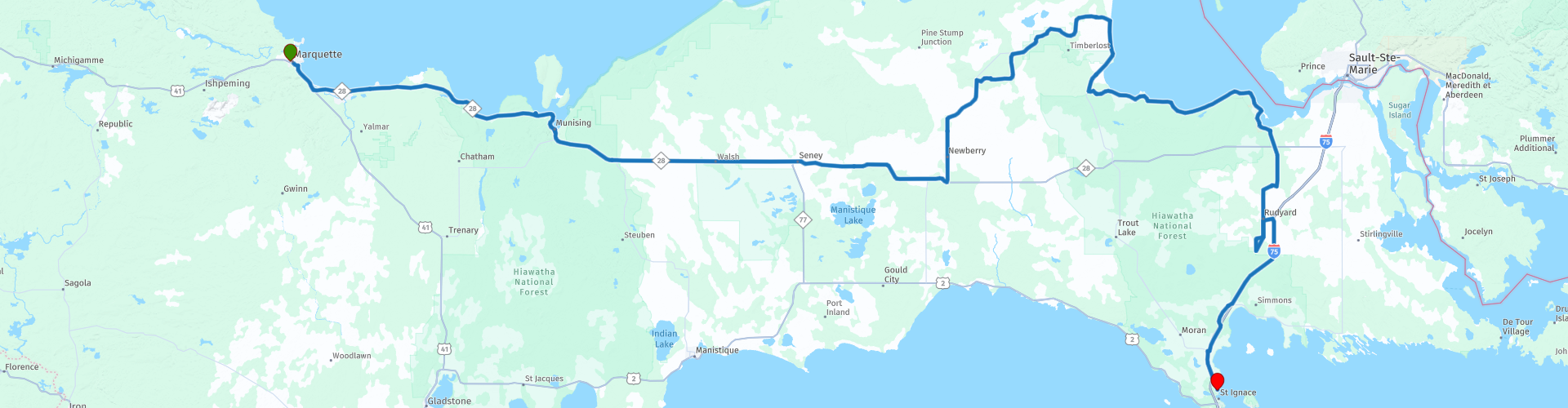
Marquette to St Ignace

This route was brought to you by:
RouteXpert Nick Carthew - (MRA Master)
Last edit: 29-10-2021
 Route Summary
 This route travels along the southerly shore of Lake Superior then through the Hiawatha National Forest. The scenery for the day is lakes and forest with a lunch stop in Paradise!
This route is unhurried, laid back and scenic so it gets 4**** stars from me.
 Share this route


Animation

Verdict


Duration
8h 55m

Mode of travel
Car or motorcycle

Distance
368.96 km

Countries

 RouteXpert Review
 This route starts by following the southern shore of Lake Superior, or Gitche Gumee for those that have read 'The Song of Hiawatha' poem written in 1855 by Henry Wadsworth Longfellow.
By the shores of Gitche Gumee,
By the shining Big-Sea-Water,
Stood the wigwam of Nokomis,
Daughter of the Moon, Nokomis.
Gitche Gumee is also an opening line to one of my favourite songs: Wreck Of The Edmund Fitzgerald - by Gordon Lightfoot
The legend lives on from the Chippewa on down
of the big lake they called Gitche Gumee.
The lake, it is said, never gives up her dead
When the skies of November turn gloomy.
There are many photo opportunities along the shore of Gitche Gumee so make sure your camera is fully charged. Taking into account the photo stops, you'll be in the small town of Christmas in 1 hour.
Situated just 4-1/2 miles from Munising on M-28, this town is in all reality the town of the Christmas season. During the winter, it's a scenic Christmas wonderland. In the summer, the agate beaches of Lake Superior, the roadside santas, stores and signs all welcome you to Christmas, Michigan, a "must" on your Upper Michigan travels.
On the outskirts of town, and before stopping for a coffee you can visit Bay Furnace Park in Christmas, (a National Forest Campground and Picnic Area) that was originally the town of Onota where a huge stone blast fumace was built in 1869 to make iron. Ships carrying iron ore docked at the long pier and the iron was smelted in the forge and melted into "pigs". The "Pig Iron" was then shipped to the lower Great Lakes. In 1877 the town, also known as "Bay Furnace", was destroyed by fire leaving only the iron smelting kiln.
There are more viewpoints worthy of a photo as you leave Christmas and don't miss the Munising Front Range Lighthouse at Munising RP 13.
Leaving Munising takes you away from Gitche Gumee and into the Hiawatha National Forest.
Located in Michigan's wild and scenic Upper Peninsula, the Hiawatha National Forest's dramatic shorelines lie nestled up to Lakes Superior, Huron and Michigan -- three of the five great lakes. There are more than 2000 miles (3200 km) of forest roads and trails designated open for motorised use, this route only uses surfaced roads. The road through the forest is long and arrow straight, kick back, relax and enjoy the trees, and trees, and treeeeees. 90 minutes later and you'll arrive at a crossroad where you'll turn left for Paradise! There are fast food restaurants for coffee and gas stations for fuel here.
Heading in a north east direction through more forested lands, you'll arrive at Tahquamenon Upper Falls. It really is worth stopping here for yet more photos. The Tahquamenon Lower Falls are a few miles further on and then you'll arrive back on the shore of Lake Gitche Gumee in Paradise! What a name.
Founded in 1925, Paradise is surrounded by state and national forests and its main business is tourism. It is considered one of the gateways to the Tahquamenon Falls. You can take the coast road up to Whitefish Point to visit the lighthouse and Great Lakes Shipwreck Museum, the have the bell from the SS Edmund Fitzgerald. It'll take about an hour round trip to visit Whitefish Point. I have suggested Paradise as a lunch stop, there are a selection of eateries allowing you to tell your friends that you dined out in Paradise just after Christmas!
You travel around the coast again with more photo stops until you reach RP 30 Point Iroquois Lighthouse.
From birch bark canoes to giant ore freighters, this unique point of land has influenced travel for centuries. Lake Superior, the deepest and coldest of the Great Lakes, was especially hazardous in this area because of dangerous weather conditions and the high volume of traffic on the water from ships leaving and approaching the Sault Ste. Marie locks. Even with the aid of the light and fog horn at Point Iroquois, ships occasionally foundered in the passage. Sixteen crewmen lost their lives in the freezing lake when the Steamer Myron went down in 1919 during one of the infamous "Storms of November". Finding the bodies as they washed ashore, lightkeeper Elmer Byrnes took them to an undertaker in the nearby town of Brimley. The undertaker would pay $10 apiece for "floaters".
Climb the spiral staircase to the top of the 65-foot light tower. Observe the beauty of Canada just 3 miles away across the lake, and the ocean-going freighters as they come and go through the Soo Locks.
There's a coffee house a couple of miles down the road and then a couple more miles and you'll be heading south and it's time to say goodbye Gitche Gumee.
The road south is through a mixture of forested and agricultural land, and again it has an unhurried feel making it a relaxing ride. In just 1 hour, you'll be arriving at your hotel for the night in Saint Ignace on the shore of your third Great Lake - Lake Huron.


 Links
Links  Usage
Usage Want to download this route?
You can download the route for free without MyRoute-app account. To do so, open the route and click 'save as'. Want to edit this route?
No problem, start by opening the route. Follow the tutorial and create your personal MyRoute-app account. After registration, your trial starts automatically.  Disclaimer
Use of this GPS route is at your own expense and risk. The route has been carefully composed and checked by a MyRoute-app accredited RouteXpert for use on TomTom, Garmin and MyRoute-app Navigation.
Changes may nevertheless have occurred due to changed circumstances, road diversions or seasonal closures. We therefore recommend checking each route before use.
Preferably use the route track in your navigation system. More information about the use of MyRoute-app can be found on the website under 'Community' or 'Academy'.