Unesco Biosphaerenpark Kaernter Nockberge Rundtour

This route was brought to you by:
RouteXpert Chantal HV - RouteXpert
Last edit: 12-04-2020
 Route Summary
 driven on 24/08/2011
checked everything and checked for Garmin and TT on 20/03/2019
The motorbike heaven of Carinthia ... Probably one of the most beautiful mountain roads in Austria ...
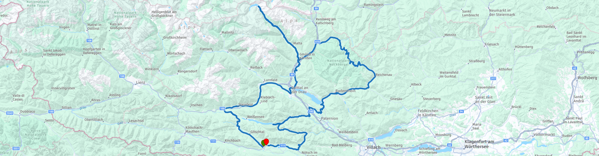
Hermagor / Drautal - Spittal - Seeboden - Treffling - Gmünd - Kremsbrücke - Innerkrems - Nockalmstraße - Ebene Reichenau - Bad Kleinkirchheim - Döbriach - Ferndorf - Olsach - Zlan - Stockenboi - Weissensee Ostufer - Ground - Crosses - St. Stefan - Hermagor
 Share this route


Animation

Verdict


Duration
5h 46m

Mode of travel
Car or motorcycle

Distance
286.92 km

Countries

 RouteXpert Review
 The tour falls under the category "easy" (Austria uses "easy, medium and hard"). Wide winding roads and on the narrower streets to Maltatal there are no problems for beginners, since there is one-way traffic. Sufficient stops on the way with a nice view or to eat or drink. 5 * route.
The fascination Biosphärenpark Nockberge has still thrilled every biker. Start in Hermagor direction Weissensee, over the Kreuzbergpass (1077 m) to Greifenburg, and on the B 100 to Spittal / Drau. Worth seeing is the castle Porcia with the informative museum of local history (after RP 9 3rd street right). In Spittal there are also good tank options.
Continue to Millstätter See and Gmünd. A detour leads through the Malta Valley and the Maltatal High Alpine Road (toll road) to the imposing Kölnbreinsperre, Austria's largest concrete dam at 2000 m RP 13. Lunch at the Berghotel Malta, where we also visit the museum.
On our return we also visit the Porsche Museum of Helmut Pfeifhofer RP 15. Do not expect anything gigantic modern here, no, it is the private collection in a very large garden shed. In good weather, there is a terrace in the garden where you can get coffee and ice cream. I had to add a few extra route points to get the same route for the TT and the Garmin.
From Gmünd it goes on to the most beautiful mountain roads in Austria: the Nockalmstraße (toll road), 35 km pure biker enjoyment. Good rest stops in quaint taverns and huts, where real Carinthian fare comes on the table, for example bell hut RP 22. The route continues to Bad Kleinkirchheim, Radenthein, Döbriach, over the splendor (fantastic view over the Millstättersee) to Ferndorf in the direction of Stockenboi to the Weissensee east bank. Pure nature. After a little rest on RP 28, continue in the direction of the ground and cross, over the Windische Höhe back to Hermagor.
** The Nockalmstraße leads through the middle of the park and was created under the greatest possible protection of nature.
It was completed in 1981 and is about 35 km long. The starting points of the road are in the east the municipality level Reichenau and in the west the municipality Krems in Carinthia. In 52 curves, the road winds through the Nockberge, the highest elevation of the Nockalmstraße is the Eisentalhöhe (2042 m above sea level). Since the opening, the Nockalmstraße is a popular destination by car, motorcycle, bike or on foot. Along the way you will find many stops, resting places, theme trails and children's playgrounds next to the impressive natural landscape.
** Toll: On the initiative of motorcycle country Carinthia, a combined ticket was launched on the panoramic road ticket Carinthia, which gives the motorcyclist a price advantage in the 5 panoramic roads. Grossglockner High Alpine Road, Nockalm Road, Villacher Alpenstraße, Goldeck Panoramastrasse and Malta Hochalmstraße are integrated into this ticket. A ticket consists of four sections, each street corresponds to one section (exception: Großglockner High Alpine Road, two sections). This inexpensive advantage card is available as overnight guest exclusively at all motor hotels. (2019: 37.50 euros).


 Links
Links  Usage
Usage Want to download this route?
You can download the route for free without MyRoute-app account. To do so, open the route and click 'save as'. Want to edit this route?
No problem, start by opening the route. Follow the tutorial and create your personal MyRoute-app account. After registration, your trial starts automatically.  Disclaimer
Use of this GPS route is at your own expense and risk. The route has been carefully composed and checked by a MyRoute-app accredited RouteXpert for use on TomTom, Garmin and MyRoute-app Navigation.
Changes may nevertheless have occurred due to changed circumstances, road diversions or seasonal closures. We therefore recommend checking each route before use.
Preferably use the route track in your navigation system. More information about the use of MyRoute-app can be found on the website under 'Community' or 'Academy'.