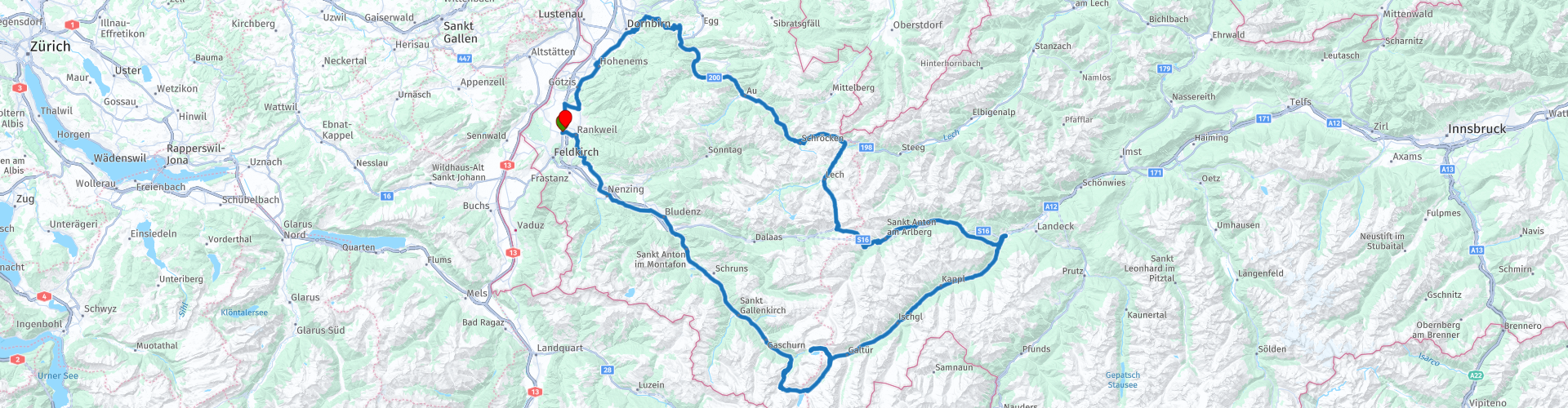
Vorarlberg roundtrip 3 Rankweil to Bielerhoehe to the Arlberg and Boedele

This route was brought to you by:
RouteXpert Edgar Hofer
Last edit: 15-04-2023
 Route Summary
 This is the 3rd route in my Vorarlberg circular tours collection.
After the first two round tours it's time for a 5 passes tour. The tour takes you through the Montafon, the southernmost part of Vorarlberg, to the Silvretta High Alpine Road. After a short detour to Tyrol, back to Vorarlberg to drive back to the Rhine Valley via Lech and the Bregenzerwald.
Start and finish: Rankweil (gastronomy workshop)
Course: Rankweil - Montafon - Bielerhöhe - Arlbergpass - Flexenpass - Hochtannbergpass - Bödele - Rankweil
The route is identical for TomTom, Garmin and MyRoute app.
If you drive this tour, please note the following information:
● Mountain experience necessary (partly narrow, narrow roads)
● Bielerhöhe and the ride from Lech to Warth, depending on the snow conditions
Open late May early June.
● For a longer stay in Vorarlberg I recommend a motorway vignette
buy. Motorcycle 10 days 5.80, 2 months 14.50 (as of 2023)
I definitely give this tour 5 stars. It offers everything that a great motorcycle tour needs. Five passes, picture-book landscapes and very good roads.
 Share this route


Animation

Verdict


Duration
7h 46m

Mode of travel
Car or motorcycle

Distance
251.22 km

Countries

 RouteXpert Review
 The first kilometers lead back through the Walgau (Tour 1) to Bludenz. Anyone in possession of a motorway vignette can skip the drive through Bludenz (points 7 and 8) and drive directly on the expressway to point 9.
You are now at the entrance to the Montafon, the southernmost valley in Vorarlberg. After approx. 30 km, past the well-known ski areas of the Montafon, you will reach Partenen. Shortly after Partenen you have to make a short stop and pay the toll at the toll station (EUR 14.50 as of 2023). But you won't regret a cent of it.
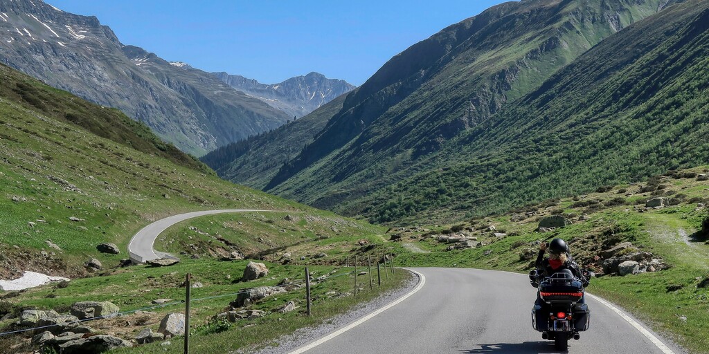
Now, it's time for rock'n'roll. Even in summer, early in the morning, it can still be very cool in the back of the Montafon. But in a few minutes their hearts will warm up again. What follows now is an Eldorado for motorcyclists. Long curves and tight curves alternate on a perfectly constructed road, like the rhythm of a good song. The Silvretta High Alpine Road is one of the most beautiful alpine roads in Europe. But beware, don't let yourself be distracted by the fascinating mountain world, always full concentration on the road. Instead, stop for a moment and admire the mountain world, the Silvretta, in peace.
A little hint: Jet helmet drivers should take a look in the rear-view mirror shortly before the pass summit, because one or the other fly could have gotten lost between the teeth from the many grins ????.
At the restaurant on the Bielerhöhe, it's time for the first coffee break. After a short sightseeing tour of the dam, you can enjoy coffee on the terrace with an unforgettable view.
After the break, they continue through the Paznauntal. The road leads through breathtaking scenery, past famous ski resorts to Landeck.
To explore the third reservoir and see the Silvretta mountains from a different perspective, I can heartily recommend the short detour to the Kops reservoir.
Galtür is right at the beginning of the Paznauntal. In February 1999, Galtür was the scene of one of the largest avalanche accidents in the Alps. An avalanche about 400 meters wide thundered on Galtür on February 23, 1999 at around 4 p.m. It destroyed numerous houses and buried more than 50 people.
The Alpinarium was built in Galtür to commemorate this event. The museum is an exhibition, information and documentation center all in one.
A few kilometers after Galtür you reach Ischgl, the largest community in the Panznaun Valley. Ischgl has developed from a small mountain farming village into one of the largest tourist communities in all of Austria.
At the exit of the Paznauntal you will see the Trisanna Bridge and Wiesberg Castle on the right bridge pillar. The Trisanna Bridge is an engineering structure of the Arlberg Railway and is considered a masterpiece of the 19th century. The bridge was built in 1883 and officially opened by Emperor Franz Josef just one year later. The building has a length of 230m and a height of 87m.
Wiesberg Castle was built by the Bishopric of Chur in the 13th century. Since it is now privately owned, it can only be viewed from the outside.
The tour continues through the Stanzertal in the direction of Arlberg. Shortly before the ascent to the Arlberg Pass you reach St. Anton. St. Anton am Arlberg is one of the largest ski areas in the world and is considered the cradle of alpine skiing.
Shortly afterwards you will reach the 2nd pass of today's tour, the Arlberg Pass. A short photo stop with a souvenir photo is mandatory. There are also plenty of options for a second coffee break.
After a short descent and an adventurous ride through the Flexengalerie, you will already reach the 3rd pass of the day. On this route, the villages of Zürs, Lech, Warth and the Hochtannbergpass up to Schröcken are traversed in the opposite direction, in contrast to my 2nd tour.
After the magnificent descent from Schröcken, it's time for lunch. The range of good restaurants in Schoppernau is very large. But if you love a cozy guest garden under chestnut trees and prefer regional dishes, Gasthof Adler is the place for you.
The tour continues through the Bregenzerwald to Schwarzenberg. There the ascent to the last pass of the day begins. The Bödele with its lottery pass. The Bödele is the smallest ski area on today's tour. Due to the proximity of the Rhine Valley, it is very popular with families.
After the Losenpass you leave the Bregenzerwald and drive back into the Rhine Valley. On the drive to Dornbirn, you will again have wonderful views of the Rhine Valley and the Swiss mountains opposite.
From Dornbirn you drive back to the starting point in Rankweil. If you would like to enjoy a coffee with cake or a sensational ice cream, I can warmly recommend the Schlosscafé in Hohenems.

 Links
Links  Usage
Usage Want to download this route?
You can download the route for free without MyRoute-app account. To do so, open the route and click 'save as'. Want to edit this route?
No problem, start by opening the route. Follow the tutorial and create your personal MyRoute-app account. After registration, your trial starts automatically.  Disclaimer
Use of this GPS route is at your own expense and risk. The route has been carefully composed and checked by a MyRoute-app accredited RouteXpert for use on TomTom, Garmin and MyRoute-app Navigation.
Changes may nevertheless have occurred due to changed circumstances, road diversions or seasonal closures. We therefore recommend checking each route before use.
Preferably use the route track in your navigation system. More information about the use of MyRoute-app can be found on the website under 'Community' or 'Academy'.

Tyrol
About this region
Tyrol (; German: Tirol [tiˈʁoːl] (listen); Italian: Tirolo) is a state (Land) in western Austria. It comprises the Austrian part of the historical Princely County of Tyrol. It is a constituent part of the present-day Euroregion Tyrol–South Tyrol–Trentino (together with South Tyrol and Trentino in Italy). The capital of Tyrol is Innsbruck.
Read more on Wikipedia
View region
 Statistics
  38
38Amount of RX reviews (Tyrol)
 53864
53864Amount of visitors (Tyrol)
 6250
6250Amount of downloads (Tyrol)
 Route Collections in this region
 The 24 Most Beautiful Alpine Routes
The Alps, The Alps are a mountain range in Europe, stretching from the French Mediterranean coast in the southwest to the Pannonian Plain in the east. The area of the mountain range is more than 200,000 km².
In other words Passes and Mountain Roads!
Driving through the mountains is great! Especially over the mountain passes with hairpin bends and narrow winding roads. Every bend a different view where you can enjoy. There are many beautiful mountain passes in the Alps.
A selection that has also been incorporated into these routes:
The Stlevio Pass:
The Stelvio Pass, also known as Passo dello Stelvio, is mainly known for the stage in the Giro d'Italia. Due to the length and the difference in height, this pass is seen as one of the toughest tests in cycling. The Stelvio Pass reaches a maximum height of 2758 meters and is therefore one of the highest in the Alps. The pass connects the towns of Bormio and Prato Allo Stelvio. In winter the pass is closed due to heavy snowfall.
The Reschenpass:
The Reschenpass, also known as Passo di Resia, connects the Austrian state of Tyrol with the Italian province of South Tyrol. The pass reaches a maximum height of 1,504 meters and has been one of the most important north-south connections in the Alps in recent centuries. The pass was used long before Roman times. Along the way you will pass several highlights and historical relics. One of the highlights is the Reschensee. This lake was created after the construction of the dam and has completely submerged the village of Graun. The only thing that reminds of that is the clock tower in the middle of the lake.
Col du Galibier:
The French mountain pass Col du Galibier connects the towns of Saint-Michel-de-Maurienne and Briançon via the Col du Lautaret in the south and the Col du Télégraphe in the north. The mountain pass is part of the Tour de France and very much feared, due to the fact that it can only be reached via the other two mountain passes. The pass reaches a maximum height of 2646 meters. From there you can take a walk to the viewpoint at 2704 meters. You can admire the peaks of the Grand Galibier, Mont Blanc and La Meije here.
The Grossglockner High Alpine Road:
With a height of 3798 meters the Grossglockner is the highest mountain in Austria. To fully enjoy this impressive mountain, you can drive over the Grossglockner High Alpine Road and the accompanying pass. The route starts from Bruck am Grossglockner and ends in Heiligenblut. Of course you can drive in two directions. The pass reaches a maximum height of 2504 meters and is closed in winter due to heavy snowfall. Along the way you pass several stops with fun activities, information points, mountain huts and viewpoints. A visit to the Kaiser-Franz-Josefs-Höhe and Pasterzen Glacier is highly recommended.
The Col d'Izoard:
Just like the Col du Galibier, the Col d'Izoard is also part of a stage of the Tour de France. The mountain pass connects Briançon with the valley of the river Guil. The pass is partly located in the Regional Natural Park du Queyras and reaches a maximum height of 2360 meters. What is special about the Col d'Izoard is the barren and rocky landscape. Sometimes it feels like driving a car over the moon! Along the way you can stop at several points to enjoy the beautiful view.
The Bernina Pass:
The Bernina Express is one of the most famous rail trains in Switzerland and the Alps. The route is beautiful and partly included on the UNESCO World Heritage List. Parallel to the railway lies the Bernina pass, which connects the Veltlin valley with the Egandin valley. This beautiful Alpine road has a total length of 56 kilometers and reaches a maximum height of 2328 meters. Along the way you can enjoy views of the Morteratsch Glacier.
The Sella Pass:
The Sella Pass, also known as Passo di Sella, takes you over one of the most impressive mountain ranges in the Dolomites: the Sella massif. The pass connects Valle di Fassa with Val Gardena and reaches a maximum height of 2236 meters. At this height is also the border of the Italian provinces of Trentino and Bolzano. Along the way you can enjoy the view of this spectacular mountain world. Admire, for example, the three peaks of the Sasso Lungo massif, the Sella massif or the peaks of the Marmolada. You can also drive the Sella pass in combination with the Gardena pass, Pordoi pass and Campolongo pass.
The Grimsel Pass:
The Grimsel Pass connects Goms in Wallis with the Halis Valley in the Bernese Oberland. The pass reaches a maximum elevation of 2165 meters and is closed in winter due to snowfall. Over the centuries, the mountain pass has played an important role in trade between Switzerland and Italy. Now it is mainly the reservoirs that have an important function. These are used to generate electricity. The landscape you drive through is rugged, rocky and impressive. On top of the pass is a hotel and a restaurant with a special marmot park. The Dodensee (Totensee) is also located here. This lake owes its name to the many soldiers who died in the time of Napoleon.
The Gotthard Pass:
The Gotthard Pass, also known as Passo del San Gottardo and Saint Gotthard, connects the Swiss towns of Airolo and Andermatt. The mountain pass and associated tunnel are especially known among holidaymakers driving from Switzerland to Italy. But where the majority opt for the tunnel, it is precisely the pass that really completes the holiday. The Gotthard Pass has a length of about 26 kilometers and reaches a maximum height of 2106 meters. The route is beautiful and takes you along old villages and beautiful views.
The Silvretta High Alpine Road and Silvretta Pass:
The Paznaun Valley in Tyrol and the Montafon in Vorarlberg are connected by the Silvretta High Alpine Road. The route has a length of 22.3 kilometers and leads from Galtür to Partenen in 34 hairpin bends, via the 2032 meter high Bielerhöhe. The Silvrettasee is also located at this point, where you can enjoy a lovely walk. The pass is closed in winter due to snowfall.
The Simplon Pass:
Just like the Gotthard Pass, many holidaymakers also travel over the Simplon Pass every year. This mountain pass connects the Rhone Valley in the canton of Valais with the Valle d'Ossola in Piemonte. The pass is open all year round and reaches a maximum height of 2005 meters. Along the way you pass a number of buildings, including the well-known Simplon Hospiz from 1825. The hospiz is managed by the monks of St. Bernard. From the highest point on the pass, all kinds of hiking routes are possible and you will also come across a hotel where you can spend the night.
The Gerlos Pass:
The Gerlos Pass connects the Salzach Valley in the Salzburgerland with the Zillertal Valley in Tyrol. The pass is part of the Gerlos Alpenstraße and runs right through the Hohe Tauern National Park. Along the way you can enjoy beautiful views of the surroundings. The pass has a length of 12 kilometers and reaches a maximum height of 1531 meters. A ride over the Gerlos Pass can be ideally combined with a visit to the Krimmler Wasserfälle.
The Great St. Bernard Pass:
The Great St. Bernard Pass, better known as Col du Grand Saint Bernard, connects the Italian province of Valle d'Aosta with the Swiss canton of Valais. The pass is one of the highest in Switzerland and reaches a maximum height of 2469 meters. Like a number of other mountain passes in this list, the Great St. Bernard Pass has also been used as a connecting road for centuries. The pass is named after the St. Bernard dogs that used to help stranded travelers along with the monks. The pass is closed in winter.
The Timmelsjoch High Alpine Road:
The Timmelsjoch High Alpine Road connects the towns of Sölden in the Ötztal and Meran in South Tyrol. Tolls must be paid on the Hochgurgl - Moos route. Via a mountain road with about 60 hairpin bends you drive through a beautiful mountain world. With the Timmelsjoch Experience you can learn more about the history, the road and the environment via various stations. You can also visit the Top Mountain Crosspoint museum.
Col de l'Iseran:
With a maximum pass height of 2770 meters, the Col l'Iséran is one of the highest mountain passes in the Alps. The pass connects Bourg-Saint-Maurice with Bonneval-sur-Arc. Via a road full of hairpin bends you pass, among other things, Val-d'Isère and a side valley of the Maurienne that lies entirely in the National Park de la Vanoise. You can spot animals such as marmots and chamois and there is also a restaurant with a chapel on top of the pass.
The Gavia Pass:
The Gavia Pass (Italian Passo di Gavia) is a mountain pass in the Italian Alps, in the Lombardy region.
It is one of the highest pass roads in Europe. The road leads through the unspoilt Stelvio National Park. The road was built in the First World War to supply Italian soldiers who fought in the Italian-Austrian border area. The pass height is one of the most beautiful in the Alps. Here is the large Lago Bianco with, to the north, the mountain San Matteo (3684 meters). Lago Nero is slightly lower on the south side of the pass. Here the mountain group of the Adamello determines the view. There are many well-marked walks in the area. During the winter the pass is closed due to the heavy snowfall. The pass is often closed until May and June due to the large amount of snow.
Promoter has made a selection of the 24 Most Beautiful Alpine routes that they have set out in recent years.
The routes go through:
France
Austria
Switzerland
Italy
The most beautiful roads, the most beautiful views, the most beautiful viewpoints. The highest mountains, the fastest descents, hairpin bend after hairpin bend, you name it you can't get enough of it.
If you go on holiday in this region, take advantage of it, ALL routes in this collection have been checked and made equal for TomTom, Garmin and MyRoute-app Navigation by a MyRoute-app RouteXpert.
Have fun with this collection and while driving one of these routes. Enjoy all the beauty that the Alps and the Dolomites have to offer. Click on “View route” to read the review of the chosen route.
I would like to hear your findings about the route(s).
View Route Collection
The 12 most beautiful car and motorcycle routes in Carinthia
“Motorradland Kärnten” where you feel so wonderfully welcome as a motorcyclist!
Own website for motorcyclists, own curated routes, hotels, campsites and guest houses with attention for motorcyclists, a wonderful area where motorcyclists are very popular.
Kärnten or Carinthia, at the crossroads of the Germanic, Slavic and Roman worlds. Three cultures within a few kilometres, southern flair, culinary delights, cross-border tours. Breakfast in Italy, lunch in Slovenia, dinner in Austria - all in one day. Experience the diversity in the borderless Alps-Adriatic region, the area for motorcyclists.
Extensive day trips on winding mountain paths, romantic panoramic routes and beautiful lakes, here the 12 TOP routes Kärnten / Carinthia. Enjoy!
View Route Collection